2
#$
"
%
&$
%
'$
%
(
)$
%
*
"
+$ (
!
,
-
",
.
-.
" /
/ "!
0
, 1 2
.
2
-
-
.
-.
"
. " . " 3 4 - 5
6
"
"
. ! 07 , 1 . ( " ,-%
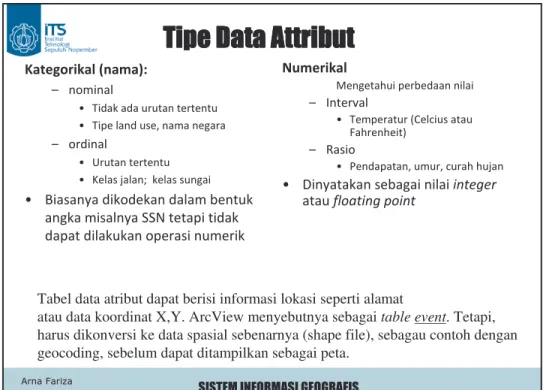
Tabel data atribut dapat berisi informasi lokasi seperti alamat
atau data koordinat X,Y. ArcView menyebutnya sebagai
table event
. Tetapi,
harus dikonversi ke data spasial sebenarnya (shape file), sebagau contoh dengan
geocoding, sebelum dapat ditampilkan sebagai peta.
!
.
,"
"
!
8
9
:
8"
8
.
8
!
0
, 8"1
8"
8
;
Parcel TableParcel # Address Block $ Value
8 501 N Hi 1 105,450 9 590 N Hi 2 89,780 36 1001 W. Main 4 101,500 75 1175 W. 1st 12 98,000 entity Atribut Key field
"
Parcel Table
Parcel # Address Block $ Value
8 501 N Hi 1 105,450
9 590 N Hi 2 89,780
36 1001 W. Main 4 101,500 75 1175 W. 1st 12 98,000
Geography Table
Block District Tract City
1 A 101 Dallas
2 B 101 Dallas
4 B 105 Dallas
12 E 202 Garland
Tujuan: menghasilkan peta atau nilai dengan informasi bagian (district) Permasalahan: tidak ada kode district yang tersedia di tabel Parcel
Solusi: join Tabel Parcel, yang berisi nilai dengan Tabel Geography yang berisi lokasi koding, menggunakan Block sebagai key field
Dua table berhubungan, atau
join
, menggunakan identifier record yang umum
(variabel kolom), tampil pada kedua tabel tersebut, yang disebut
secondary key
(atau foreign key)
, yang mungkin sama atu tidak sama dengan key field.
Secondary key atau foreign key
<$
%
&$
%
'$
%
(
)$
%
*
"
"
"
"
"
#
$ % &"
'
(
$ &"
&"
&"
) *"
+
. =" 8 -0 1 . . 7" " 7 " 0= % > 1 , % ! 3 ? . 6 8 ," " ! -. =" 8 "" @ " " . " " % ; . 7" " ! " % % ? ( 3 A % =? 3 ? % . 6 8 " " " 10
%
,
"
y-axis berupa unit (mi, feet, in, km, m, cm, mm, etc.) atau ukuran lain (seperti Latitude atauNorthing)
x-axis berupa unit (mi, feet, in, km, m, cm, mm, etc.) atau ukuran lain (seperti Longitude atauEasting)
0 1 2 3 4 5 6 7 8 9 0 R T 1 R T 2 H R 3 R 4 R R 5 R 6 R T T H 7 R T T 8 R 9 R
Dunia Nyata
Representasi Vektor
Representasi Raster
Konsep
Vektor dan
Raster
line
polygon
point
<$
%
#$
"
%
'$
%
(
)$
%
*
"
+$ (
13
8
"
"
.
8
.
.
!
8
8
.
,"
"
. (
;
. 6 B /6 /6 =
!
. 2 "
"
"
.
"
"
"
.
"
/ ,/ "
"
.
<$
%
#$
"
%
&$
%
"
)$
%
*
"
+$ (
"
="
-
0 ,
15
-
8
"
0
1
"!
/
C
D
. = 0 " C D1 . % 0 ? % 6 1
corn
wheat
fruit cl ov erfruit
oats 0 1 2 3 4 5 6 7 8 9 0 1 2 3 4 5 6 7 8 9 1 1 1 1 1 4 4 5 5 5 1 1 1 1 1 4 4 5 5 5 1 1 1 1 1 4 4 5 5 5 1 1 1 1 1 4 4 5 5 5 1 1 1 1 1 4 4 5 5 5 2 2 2 2 2 2 2 3 3 3 2 2 2 2 2 2 2 3 3 3 2 2 2 2 2 2 2 3 3 3 2 2 4 4 2 2 2 3 3 3 2 2 4 4 2 2 2 3 3 32
"-"
. 3 "-" 2 . / " E ,. 6 F #)+ 0G #))1
-
"
. " 0 8 ," " 1 . . / 9 " , : , 0 8 - 10, $
H
" 1
,
#
,"
#
"
#
. 4" . , 8 . ' ," , " "" 0 2 1 -. F ," , " "" 0 " 1 -" <$'< 0 #1
$
. 6 / " " . % < !0&
1
% &
0+
1
.-'
0
1
. " ," " 0 ! 119
( "
"
0<GI<G
<@<
<G@<G
1
%
8
"
0
1
?
"
"
,
%
"
0
-1
-20"
%
0
1
%
,
"
.
+
/"
"
+/"
"
!
Matriks Penuh--162 byte
111111122222222223
111111122222222233
111111122222222333
111111222222223333
111113333333333333
111113333333333333
111113333333333333
111333333333333333
111333333333333333
1,7,2,17,3,18
1,7,2,16,3,18
1,7,2,15,3,18
1,6,2,14,3,18
1,5,3,18
1,5,3,18
1,5,3,18
1,3,3,18
1,3,3,18
Run Length (baris)--44 bytes
Saat ini, paket GIS menggunakan kompresi komersial. Pkzipadalah rutin umum yang banyak dipakai. MrSid(dari Lizard Technology) danECW (dari ER Mapper) digunakan untuk citra. Semua menggunakan konsep yang sama. Dalam beberapa kasus, data masih disimpan dalam bentuk run-length compression, terutama untuk aplikasi remote sensing.
Merupakan kompresi “lossless”, kebalikan “lossy,”
karena data asli dapat direproduksi 22
!
"
"
,
,
,
%
8 " "
8
" "
0
1
. 0
23 A B C D A B C D A B C D A B C D
. 0
1!
0
"
!
? , 8 . - -. J - ' . -" . " -- " " " " . " !Layer Width Cell Count 1 1 1 2 2 4 3 4 16 4 8 64 5 16 256 6 32 1024
Simpan kuadran ini sebagai single 1 Simpan kuadran ini sebagai single zero
I 1,0,1,1 II 1 III 0,0,0,1 IV 0 1 1 1 1 1 1 1 1 2 2 1 2 3 4 4 4 4 5 4 4 4 3 4 2 3 4 2.5 3.5 3.25
&
#
&
#
&
#
&
#
" ("
% " " . ! , - 5 , , 0 1 " . " " K 6 ; 06 B 1 . 8 . ! . 6 " . 6 - 8" . 8" 6 ! @ 06 1 . " " -. 6 - 8" " 8 . -6 ! = 06 =1 .File 1: Veg A,B,B,B File 2: Soil I,II,III,IV
File 3: El. 120,140,150,160
A,I,120, B,II,140 B,III,150 B,IV,160
A,B,I,II,120,140 B,B,III,IV,150,160
Mulai dari pojok kiri bawah. Pojok kiri atas sebagai alternatif.
A B B B III IV I II 150 160 120 140 Elevation Soil Veg
%
6 B 6
6 =
"
?
%
A"
%
8
!
ID
Row
Col
Var1
Var2
Var3
1
1
1
b
III
150
2
2
1
a
I
120
3
1
2
b
IV
160
"
%
8"
# (
8"
(
"
"
,
)*+# ,
0
" !
? ( % 1
8"
,
!
"
. 8 C2 " D 8" "Image Image File World File
TIFF image.tif image.tfw Bitmap image.bmp image.bpw BIL image.bil image.blw JPEG image.jpg image.jpw
“geotiff” adalah file yang terdiri dari citra dan informasi “world” dalam satu file meskipun tidak sering digunakan
<$
%
#$
"
%
&$
%
'$
%
(
.
+$ (
"
"
"
"
%
%
%
%
"
"
"
"
"
% &"
#
("
" 0 " 1 G . 4"" @ . " " . " " " = 0 ,1 < . % 0 1 "" @ . A " " # . "" @ , . 4"" @ . . 1 2 7 8.
x=7 Point: 7,2 y=2 Line: 7,2 8,1 Polygon: 7,2 8,1 7,1 7,2 1 2 7 8 1 2 7 8 1 1 2 7 8%
" #
2+" 3"
2+" 3"
2+" 3"
2+" 3"
"
"
"
"
/ %
* 0
"
"
""
"
"
.
8
%
8
.
""
/
4 ! "!.
9 "
: 0
,
1
.
8"
" " "
"
"
K. %
"
L
+G
. %
"
"
/? (
M
"
Topologi --pengetahuan tentang posisi spasial relatif --memanajemen data geometri yang dikenali Topografi --bentuk permukaan lahan, khususnya elevasi
2+" 3"
" #
& '
' '
' #
& #
& '
6 ' '
6 ) '
6 ) #
6 ' #
6 ' '
7 & #
7 ' #
7 ' G
E
A
B
C
D
1 2 3 4 5 0 1 2 3 4 5C 3 0
C 3 2
D 4 2
D 5 2
D 5 0
D 4 0
D 4 2
E 1 5
E 5 5
E 5 4
E 3 4
E 3 0
E 1 0
E 1 5
File Data
%
" #
3"
43"
"
3"
43"
"
3"
43"
"
3"
43"
"
*
* 0
"
"
8
!"
"
,
5 8
""
$
.
,
""
/
"
. ?
"
" 0
% 1
-
K
.
8"
" " "
.
"
7 = > (
=
"
"
7"
?
,
M
!
2
NG
3"
3"
" #
< & '
# ' '
& ' #
' & #
) ) '
+ ) #
N ) G
F ' G
O & G
<G < G
<< < )
<# ) )
E
A B
C D
1 2 3 4 5 0 1 2 3 4 5A 1, 2, 3, 4, 1
B 2, 5, 6, 3, 2
C 4, 3, 8, 9, 4
D 3, 6, 7, 8, 3
E 11, 12, 5, 1, 9,
10, 11
File Point
1
2
3
4
5
6
7
8
9
10
11
12
File Polygon
%
" #
" ""
" ""
" ""
" ""
" 5 &53"
" 5 &53"
" 5 &53"
" 5 &53"
"
"
"
"
& " " " " " 8 0 " 1 " " " (7 " . $ . , 0 1 , -" -" -" " " , . " " 0 1 , " " " = 8 ( " " " . " " 0 1 " " -" " 0- ,1 Left Right from to35
line no. coordinates 3 x1, y1, z1 x2, y2, z2 x3, y3, z3 : : : 72 x21, y21, z21 x22, y22, z22 : : : : : : x21, y21, z21 16 x52, y52, z52 : : : : : : : : : 3 16 72 x1,y1,z1 x2,y2,z2 x3,y3,z3 x21,y21,z21 x22,y22,z22 x52,y52,z52
%
" .
+
36"
" "
"
,
""
→
?
→
,","
-%
8
-
%
" -
+
37 = 4 8 " " 8 <# <' ( 4 <' &' 4 , <' <N <N <F <' '' ( 8 '' <N <# '' ( &' <# 4 <F &' - <F '' A > =L? > > % " " " 4 <# , <' , 8 , <N , 8 ( <F -8 - &' '' 8 -a b c d e f 12 13 14 15 16 17 18 34 35 42 43 44 4546 47 48 K M P R S g h i j
%
"
&- "
38"
" " "
→
,","
-;
→
8
%
"
,
8
P
"
8 0
"
"
1
0
-
1
,
%
9
:
%
"
&- "
Node Table
Node ID Easting Northing 1 126.5 578.1 2 218.6 581.9 3 224.2 470.4 4 129.1 471.9
Node Feature Attribute Table Node ID Control Crosswalk ADA?
1 light yes yes
2 stop no no
3 yield no no
4 none yes no
Arc Table
Arc ID From N To N L Poly R Poly I 4 1 A34 II 1 2 A34 III 2 3 A35 A34 IV 3 4 A34
Polygon Feature AttributeTable
Polygon ID Owner Address A34 J. Smith 500 Birch A35 R. White 200 Main
Polygon Table
Polygon ID Arc List A34 I, II, III, IV A35 III, VI, VII, XI
Arc Feature Attribute Table
Arc ID Length Condition Lanes Name I 106 good 4 II 92 poor 4 Birch III 111 fair 2 IV 95 fair 2 Cherry Birch Cherry
I
II
III IV 1 4 3Node/Arc/ Polygon dan Data Atribut
Dibutuhkan DBMS
Data Spatial
Data Atribut
A35 Smith EstateA34 2
3"
"
% &"
#
Coordinates Table Point ID x y 1 1 3 2 2 1 3 4 1 4 1 2 5 3 21
2
3
4
5
X
Y
•Fitur dalam theme (coverage)
mempunyai identifier uniq --point ID,
polygon ID, arc ID, dll
•Identifikasi dihubungkan ke:
–Tabel koordinat (untuk ‘where’) –Tabel atribut (untuk what)
Attributes Table
Point ID model year
1 a 90
2 b 90
3 b 80
4 a 70
#
6"
(&
Titik elevasi (node) dipilih berdasarkan kompleksitas relif dan lokasi 3D (x,y,z) tertentu.
Node # X Y Z 1 0 999 1456 2 525 1437 1437 3 631 886 1423 etc Point
Polygon Node #s Topology A 1,2,4 B,D B 2,3,4 A,E,C C 3,4,5 B,F,G D 1,4,6 A,H etc
Titik elevasi dihubungkan untuk membentuk kumpulan polygon triangular; kemudian direpresentasikan dalam struktur vektor Polygon
Polygons Var 1 Var 2
A 1473 15
B 1490 100
C 1533 150
D 1486 270
etc.
Atribut Info. Database
Data atribut dihubungkan via relational DBMS (seperti kemiringan, aspek, jenis tanah dll.)
Keuntungan dibanding raster: •Point lebih sedikit
•Menangkap diskontinuitas (cth. bukit) •Kemiringan dan aspek dengan mudah dicatat Kerugian: Hubungan ke polygon lain untuk overlay membutuhkan perhitungan khusus (beberapa polygon)
A
B
C
D
6 1 2 3 4 5 E F G H"
%
"
8"
!
"
"
# !
$%&'%
6
8
8
0<#
1
8"
"
"
, E
, 8"
;
8" ,
12 3
8"
!
"
"
# ( )
$%&&*
0
&1 8
8
0
@
"
$
$
@ $
81
%
!
"
8
8"
"
,?
F$G
#GGG
6
8
$
0
,,
1
"
C
@
" D
8
8"
Shapefile adalah format paling sederhana dan sangat
umum digunakan
<$
%
#$
"
%
&$
%
'$
%
(
)$
%
*
"
4
*
Merepresentasikan
Permukaan
Tongariro National Park North Island
$ $ 6#
3
!
0 1
"
"
@
"
-
"
"
&
,
. 6
(
4
!
0
1
. 6
*
"
)
!
&
. 6
*
"
?
-"
!
!
x y z$ "
"
!
0 1
,
!
@
%
"
. % $ $ " " . 2 $ "Keuntungan
• Model konsep sederhana
• Data mudah dibentuk
• Mudah berelasi dengan data
raster lain
• Kumpulan titik irregular
dapat diubah ke titik
regular dengan interpolasi
Kerugian
• Tidak memenuhi
keragaman permukaan
• Fitur linier tidak dapat
direpresentasikan secara
linier
47
$ "
"
!
Elevation in Nepal
6"
. %
8
,
8
0
1
.
8
. 3
,
0
1 !"
.
Kumpulan tetangga, segitiga
non-overlap dihitung dari titik
irregular dengan koordinat
horisontal x, y dan elevasi
vertikal z
/" " "
!7
" . ? H , . H . " -" H . = H , = " " 8" 3 4" " "8 2 + ? " "8 2 ,$ ,? @ " bukitlembah puncak bukit
Garis kontur, atau isoline, dari elevasi konstan pada interval tertentu