Geology of the Ruwai Iron and Zn-Pb-Ag Skarn
Deposits Lamandau District, Central Kalimantan
Geologi Cebakan Besi dan Skarn Zn-Pb-Ag Ruwai,
di Distrik Lamandau, Kalimantan Tengah
Lucas Donny Setijadji, Fenny Tamba, and Arifudin Idrus
Department of Geological Engineering, Gadjah Mada University,
Jln. Grafika 2 Bulaksumur Yogyakarta 55281
ABSTRACT
The Ruwai Fe and Zn-Pb-Ag skarn mineralization can be used as a model of mineralization style as-sociated with the Cretaceous-Early Tertiary Schwaner Mountain granitoids, southwestern Kalimantan. Skarn mineralization is a product of contact metasomatism between a subbatholitic quartz diorite and sedimentary-volcanic units. At the vicinity to the magma source, mineralogically the skarn is dominated by extensive prograde garnet and magnetite-hematite assemblage. Towards the distal zone, Zn-Pb-Ag ores are present associatedly with central garnet-dominated skarn along the fractures and bedding contacts that change rapidly into pyroxene-dominated skarn and hornfels or marble. Overprinted by retrograde event, this deposit produces fault-controlled chlorite-epidote skarn and clay-rich alteration at the upper part of the ore. The best site for mineralization is a junction between two major faults and a fold that connects the magmatic source and favorable lithology, i.e. contact zone of siltstone and limestone. Stream sediment, VLF, and ground magnetic surveys are proven as effective tools to locate the mineralization, while soil survey showed mixed results. Differentiation of gossan types
and identification of near-surface phenomena along the ore-bearing faults are important geological
observations leading to the discovery of main ore bodies at depth.
Keywords: Ruwai iron, Zn-Pb-Ag skarn deposit, Lamandau District
SARI
Mineralisasi Fe dan skarn Zn-Pb-Ag Ruwai dapat digunakan sebagai sebuah model tipe mineralisasi yang berasosiasi dengan granitoid Kapur-Tersier Awal di Pegunungan Schwaner, Kalimantan bagian tenggara. Mineralisasi skarn merupakan produk metasomatisme kontak antara diorit kuarsa subbatolit dengan satuan-satuan sedimen-vulkanik. Di sekitar sumber magma, secara mineralogis skarn didominasi oleh garnet prograde yang ekstensif dan kumpulan magnetit-hematit. Ke arah zona distal, bijih Zn-Pb-Ag hadir bersamaan dengan skarn yang didominasi oleh garnet di sepanjang kontak retakan dan alas yang berubah dengan cepat menjadi skarn yang didominasi oleh piroksen dan hornfel atau marmer. Karena ditimpas oleh peristiwa retrograde, deposit ini menghasilkan skarn klorit-epidot yang dikontrol oleh sesar dan alterasi kaya akan lempung pada bagian atas bijihnya. Tempat terbaik untuk mineralisasi adalah pada pertemuan antara dua sesar utama dan sebuah lipatan yang menghubungkan sumber magma dengan litologi yang baik, yaitu zona kontak batulanau dan batugamping. Sedimen sungai, VLF, dan survei magnet tanah terbukti merupakan alat yang efektif untuk melokalisasi mineralisasi, sedangkan survei tanah menunjukkan hasil campuran. Diferensiasi
tipe gosan dan identifikasi fenomena dekat permukaan di sepanjang sesar pembawa bijih adalah
observasi geologi yang penting yang mengarah pada penemuan tubuh bijih utama di kedalaman.
INTRODUCTION
The Ruwai Fe-base metal mineralization, located in the Lamandau District, Central Kalimantan, is a product of intrusion of Cretaceous-Early Tertiary granitoids into Cretaceous to Triassic sedimentary-volcanic units. Despite its small size (submillion tons of Zn-Pb-Ag ore), its presence is important for there are very few technical reports available on metallic mineralizations in this district which is part of the Cretaceous Sunda Shelf or Scwanner Mountains Arc. Additionally, recent rising interests on iron ores have contributed to the increasing prospect of this mineralization style. There-fore, different styles of skarn mineralization located within the Ruwai mining area can be used as a model of metallic mineralization styles within a granitoid belt.
This paper focuses on the historical per-spective of the discovery of deposit, key elements on geology, geologic structures, alteration and mineralogy of deposits, and key geochemical and geophysical features leading to its discovery.
EXPLORATION HISTORY
The earliest investigation data on the area dates back in 1918 when a Dutch explo-ration team led by Frijling identified the occurrences of contact metasomatism and associated mineralization between intrusive rocks and sedimentray units. Later, Van Be -mellen (1949) also reported the occurrence of iron bodies at Gojo Hill.
A systematic exploration programme was initiated in year 1987 by Renison Goldfields Consolidated Ltd., with targets for gold and base metal mineralization. Renison identi-fied gold anomaly within stream sediment -80 mesh, but until the end of their explo-ration programmes in 1991 they did not
discover its source. Nevertheless, at Ruwai area, Renison managed to start an initial drilling programme in years 1990 - 1991 consisting of sixteen drill holes totalling 1554 m. However, the results were not satisfactory. Following a change in owner-ship of the property in 1992, the explora-tion programmes were continued by PT Tebolai Seng Perdana which reinterpreted geological data and designed an explora-tion programme for Zn-Pb-Ag skarn target. An intensive drilling programme was done within two periods: 1993 - 1994 and 1995 -1996. A total of ninety nine drill holes to-talling 7129.55 m were completed during 1990 - 1996 scattered within an area of 2,000 x 500 m. From this, sixty eight holes (4342.35 m) related directly to the Ruwai Zn-Pb-Ag deposit. A feasibility study was commenced only for the Ruwai deposit in year 1996, from which intensive drillings at a 25-m interval had been completed within an area of 250 x 200 m. A geological reserve of 325,000 tonnes@13.57% Zn, 5.44% Pb, and 375 g/t Ag was obtained at calculation using a cut off grade 1% Zn. At 1996 situ-ation, this figure brought to a conclusion of an economically marginal deposit.
In year 1997 exploration area at Ruwai was joined into the Contract of Work (COW) area of PT Scorpion Schwaner Mineral, in which re-evaluation of geochemical and field data were conducted PT. Scorpion Schwaner Mineral (SSM, 1999). David Cooke and Kitto of University of Tasmania made evaluation of the COW project in 1997 whose report suggested the potential for ex-tensions of Ruwai Zn-Pb-Ag skarn (Cooke and Kitto, 1997). However, finally all exploration programmes were terminated in late 1990s and the COW area was returned to the government of Indonesia.
(KP) from the government of Lamandau District, Central Kalimantan. Exploration data produced by previous COW holders are used to start a mining operation of the Ruwai deposit since year 2008. Besides the base metals, iron was also a commodity of interest. However, as results of global decreasing commodity price since mid 2008, evaluation of iron ore for its devel-opment is currently stopped. During period 2008 - 2010, several mining development programmes have been executed, such as developing a GIS database, reinterpreta-tion of geochemical and geophysical data, geological mapping, geophysical surveys (ground magnetic, AMT, and IP), and finally drilling campaigns. On the drilling, two campaigns have been completed, i.e. first in
year 2008 with fourteen drill holes totalling 2,522.83 m and second in 2009 - 2010 with fifty holes totalling 2,527.86 m.
REGIONAL GEOLOGY
Tectonic Setting
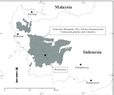
KP area is located within the Schwaner Mountains that extends from the western to central parts of Kalimantan (Figure 1). This physiographic unit is underlain by Paleozoic – Mesozoic shelf sedimentary units intruded by granitic rocks of Creta-ceous age forming the Sunda Shelf Arc (Carlile and Mitchel, 1994) or Schwaner Arc (Cooke and Kitto, 1997). It corresponds to the Cretaceous continental arc magmatism that produced 200 km wide and at least 500 km long E-W trending belt of I - type granitoids, mainly consisting of batholiths of tonalite and granodiorite with minor mafic rocks and granite (William et al., 1988, in
Cooke and Kitto, 1997). According to exist-ing radiometric data, two major periods of
Figure 1. Location of Ruwai deposit within the Schwaner Mountains of SW Kalimantan.
Pontianak
Kuching
Malaysia
Indonesia
Schwaner Mountains: Pre- Tertiary basement and Cretaceous granites and volcanics
Ruwai area Palangkaraya
Banjarmasin
0 200 400 km
111 Eo
111 Eo
114 Eo
114 Eo
3 So
0o
0o
Cretaceous magmatism are identified: the Early Cretaceous calc-alkaline tonalites and granodiorites typical of subduction-related products and the Middle-Late Cretaceous alkaline granites of post-subduction stage. Minor Late Cretaceous to Early Tertiary basic to intermediate volcanism occurred after the granite emplacement.
Although the mid-Tertiary Central Kaliman-tan Arc is also present in the western and central Kalimantan (e.g. Carlile and Mitch-ell, 1994), such volcanics are not present in the vicinity of the KP area.
Stratigraphy
The studied area is located in the Tumbang-manjul Quadrangle within the 1:250,000 geological maps of Kalimantan (Margono et al., 1995). Geological units mapped within this map sheet are very limited, probably due to the dense coverage of a tropical forest. According to this map sheet, lithology is dominated by complexes of Sepauk Tonalite (104 - 123 Ma), Sukadana Granite (86.3 - 103 Ma), and Kerabai Volcanic Rock (Late Cretaceous).
Geological mapping and data compilation during the COW era exposed more variable lithological units. In general, the lithology is classified into several units as follows. The oldest rocks of probably Permo- Carbon in age consist of slate, phyllite, and schist (Pi-noh Metamorphics). Younger rocks of Late Triassic-Middle Cretaceous comprise two main units; first the sedimentary rocks com -posed of limestone, sandstone, and siltstone (Ketapang Complex) and andesitic, dacitic to rhyolitic volcanics (Kuayan or Matan Volca-nics). These units are then intruded by series of intrusions within the Schwaner Arc vary-ing from granitic to basaltic compositions. At the district scale surrounding the Ruwai deposit, intrusive rocks are classified into three groups, i.e. Late Cretaceous monzonite, granodiorite, and granite (Sukadana
Gran-ite SuGran-ite); Late Cretaceous-Early Tertiary diorite and quartz diorite, and finally Early Tertiary andesite plug, flow, and dolerite (Bunga Volcanics, which can be correlated to the Kerabai Volcanics).
Geologic Structures
Tebolai exploration team using satellite imagery can identify geologic structures which are dominated by lineaments trend-ing NNW-SSE, NW-SE, and at smaller amounts WSW-ENE. NW-SE lineaments are represented as fault lines along the river valleys and hill ridges. The WSW-ENE lineaments are only identified surrounding the Ruwai deposit, characterized by strike-slip movements as a result of regional E-W compressive force.
Mineralization
Surrounding the Sukadana batholites, many mineralization occurrences are identified. Styles of mineralization consist of Zn-Pb ore, hematite–magnetite ore, alluvial gold within terrace gravels, and probably primary gold. Zn- Pb mineralizations are present at Riam Kusik, Ruwai, and Labau. Hematite-magnetite mineralizations are identified at Mount Karim and Mount Gojo (at vicinity to Ruwai Zn-Pb), Bt. Petai, and Bt. Sejam -bun. Iron and base metal mineralizations are related with intrusions of Sukadana Granite into older volcanic and sedimentray rocks. Alluvial gold works are found at Temaja and Batang Kawah Rivers near the Labau pros -pect, and in Mentobi River at Gerunggang prospect. Primary gold is also probably present at Temaja.
GEOLOGY OF RUWAI MINING AREA
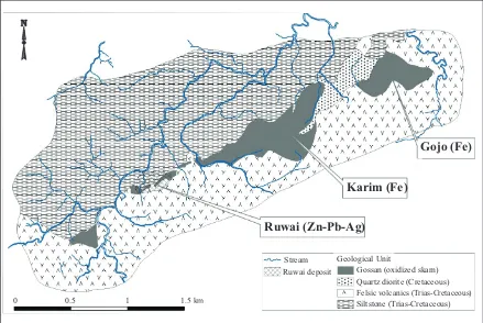
mineralization zones (Figure 2) that covers an area of 2,000 x 500 m. Key geologi-cal features within the mining area are as follows. There is a strong evidence that ore deposits, at the surface represented by gossan, are alligned along an ENE-SSW trend (approximately N70oE). This main trend also divides into two main lithologi-cal units, i.e. sedimentary unit at the NW and volcanics at SE sides. Therefore, this trend represents main geologic structure that controls the mineralization. The only sub-batholith size intrusive rock present is acid intrusive (quartz diorite) located at the NE part, and is spatially located near the widely distributed gossan of magnetite-hematite skarn mineralization at Gojo and Karim. On the other hand, Zn-Pb-Ag skarn mineralization at Ruwai is located away of any major intrusion, despite many small dykes are present cutting the ore.
Lithology
Volcanic rocks
Volcanic rocks form the southern block of the main ENE-SSW structural trend. The majority of volcanics have been altered, but based on relict textures and surviving quartz, it is concluded that volcanic rocks are dominated by acidic volcanics of ex-plosive origins, some of which are welded tuffs. While mapping, quartz is effectively used to differentiate volcanics from sedi-mentary rocks.
Sedimentary rocks
Sedimentary rocks consist mainly of silt-stone at the upper part and limesilt-stone at the lower part. Only siltstone is exposed at the surface, forming the northern block of the mining area separated by the main ENE-SSW structural trend. In some parts,
Figure 2. Simplified geological units and surface extension of gossan (oxidized skarn) in the Ruwai mining district, based on 1990s Tebolai’s map.
0 0.5 1 1.5 km
Stream Geological Unit
Gossan (oxidized skarn) Ruwai deposit
Quartz diorite (Cretaceous) Felsic volcanics (Trias-Cretaceous) Siltstone (Trias-Cretaceous)
Gojo (Fe)
Karim (Fe)
siltstone is found intercalated within sand-stone and volcanics.
Intrusive rocks
The largest intrusive body is quartz diorite outcropping at the valley between Mount Gojo and Mount Karim. The quartz diorite is fresh, medium-grained, phaneric with compositions of plagioclase, quartz, hor-blende, and magnetite (i.e., I-type series). This quartz diorite body seems to be an upper tip of a much larger batholith-size body that was emplaced following the main ENE-SSW structure. In fact, much larger intrusion is found to SE of the mining area. Other intrusive rocks of younger ages are dominated by narrow dikes and sills of (from older to younger) microdioritic, dol-eritic, andesitic, and basaltic compositions. These narrow intrusive rocks (except basalt) are common within the Ruwai deposit area. The widths of dikes and thickness of sills range from less than 1m up to 5 m. The trends are dominated by NNW- SSE and, at a smaller number, NE-SW. Dolerites, andes-ites, and basalts were definitely emplaced after the mineralization, in which their presence tends to destroy the ores, while microdiorite is still not clear either it was co-mineralization event or postdated min-eralization. Microdiorites are mostly found altered into chlorite-epidote assemblage.
Geologic Structures
The most distinctive structure is the ENE-SSW one that separates two lithological unit blocks and becomes the place of min-eralization. This main geologic structure has the main trend of N70oE. There was an argument about the nature of this structure, either it is a thrust fault (Tebolai’s explora-tion team) or a normal fault (Cooke and Kitto, 1997). Our observation data prefer to the thrusting movement, in which the thrust plane dips approximately 40o to SSE. It means that the volcanic unit at the
southern block was thrust onto the sedimen-tary northern block. Thrusting events also produce anticlinal fold especially within the footwall block that is composed of siltstone and limestone. Thrust fault plane becomes the main channel way for the migrating quartz dioritic magma. In this case, quartz diorite and some of the micro-diorite were found emplaced along the main thrust fault plane. Additionally, one microdiorite sill is also found emplaced within the folded strata following the contact zone between limestone and siltstone. Several stages of faulting events are observed by many gouge clay bands; they occurred both pre- and postmineralization event.
Another important geologic structure is a strike-slip fault zone with NNE-SSW trend N10 - 25oE and steep dip (70 - 90o E) which is located directly west of Ruwai deposit. It was initially defined by a VLF-EM survey and now is confirmed during mapping on the open pit. The difference is that it was initially interpreted by Tebolai’s exploration team as a postmineralization event but now it is known as the main feeder zone for mineralization. Nevertheless, postmineralization movements are in fact also observed.
Based on existing data, it is likely that mineralization occurred within a com-pressive regime. Extensional faults during mineralization event were probably minor but important in localizing magmatic fluids especially within crest zone of anticlinal fold on limestone-siltstone contact. Exten-sional faults are also present as steep dipping normal faults crossing the thrust, and are then filled by intermediate-basaltic dykes and mainly are postmineralization events.
Alteration and Mineralization
on their metallic associations, skarn deposits are classified into two types, i.e. iron skarn and Zn- Pb-Ag skarn. They show a typical zonal mineralization centred on an intrusion, in which proximal zone is dominated by iron ore while distal zone is by Zn-Pb-Ag (e.g.
Einaudi et al., 1981; Meinert, 1993; Taylor, 1996).
Iron skarn
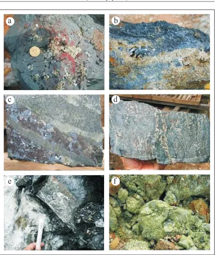
Iron skarn deposits are present at Mount Gojo and Mount Karim, in which a di-Figure 3. Different types of skarn and ores at Ruwai. a. Magnetite skarn with Cu sulfides. b. Bands of Zn-Pb sulfides within garnet skarn zone. c. Bands of Zn-Pb sulfides within pyroxene skarn zone. d. Sulfide zoning from Zn-Pb rich (left) into pyrite-rich (right) within pyroxene skarn. e. Bottom of mineralization, in which pyroxene-sulfides skarn (right side, darker) changes into marblelized limestone (left, whitish). f. Light green epidote-chlorite (retrograde) skarn at the uppermost part of mineralization.
a
c
e
b
d
rect genetic association with subbatholithic intrusion of quartz diorite is evident.
Observation on the outcrops suggest that iron skarn bodies are found as folded strat-abound layers of almost purely magnetite (Figure 3a) with the thickness ranges from 1 to 8 m at the contact zone between quartz di-orite, which was emplaced within the thrust fault plane, and volcanic rocks that form the hanging wall. Directly at the contact zone, iron skarn also contains variable amounts of garnet and Cu-Zn-Pb sulfides, some of which are associated with coarse quartz veins (Figure 3b). At depths, based on drill hole data, iron ores are also present within the footwall block of the thrust fault. Coring data show that iron ores are characterized by a mineral assemblage of garnet, magnetite, and hematite, and in some parts contain coarse quartz veins associated with sphaler-ite. Based on its mineral assemblages, iron skarn is classified into prograde skarn. Due to multiple deformation events, most of the iron ore bodies are found strongly brecci-ated. The broken nature of ores at the surface has made lots of confusions during the initial mapping programme to either map them as insitu or transported materials.
Typical grades of iron ores are variable. The massive magnetite bands contain the highest Fe contents, typically >50% Fe with maxi-mum value is about 65% Fe, with vari-ous contents of Cu, Zn, and Pb (negligible to several %). When oxidized, the limonitic soil among the iron ore fragments contains 30 - 45% Fe.
Zn-Pb-Ag Skarn
The presence of Zn-Pb-Ag skarn is well represented by the Ruwai deposit (Figure 3). Ore bodies are mainly found as stratabound massive sulfides at the contact between siltstone (upper part) and limestone (lower part). The absence of any large intrusive rocks at the vicinity of this deposit and
spatial separation from the iron skarn sug-gests that this mineralization was formed at the distal zone away from the magmatic source (quartz diorite). The major NNE-SSW strike-slip fault at the west margin of Ruwai deposit is considered as the main feeder zone for the upflowing magmatic fluids outside the main body of the quartz diorite intrusion. Evidence that supports this conclusion includes the presence of garnet and magnetite within skarn alteration-mineralization found along this fault zone. Away from the main batholith body and from the main feeder zone, magmatic fluids migrated laterally following a contact zone between siltstone and limestone to form stratabound ores. Here, a narrow garnet zone (thickness few cm up to 2 m) is found along the fractures or bedding planes in which magmatic fluids were once flowing. From this garnet zone, alteration migrated downward and upward. Towards the down-side (limestone), alteration zones change from garnet to pyroxene to finally marble within 2 to > 5 m zone (Figure 3c and d). All alteration zones represent a prograde skarn stage. On the other hand, towards the surface, skarn alteration zones change into two directions. First, away from any frac-tures, alteration changes from the proximal garnet zone to outer pyroxene to hornfels and finally indurated siltstone (i.e. prograde alteration). On the other hand, near the fracture zones, such prograde alteration is overlapped by retrograde alteration that consists of the inner chlorite-epidote skarn and outer clay alteration before grades out-ward into indurated siltstone.
the garnet zone, massive sulfides with spec -tacular grades of up to 40% Zn, 25% Pb, 3% Cu, and 2,000 g/t Ag are found at different thicknesses. This is the main zone of min-eralization. The thickest zone is about 15 m, located along the crest of anticline, in which the folded and strongly fractured limestone is accumulated and it becomes the most favourable site for mineralization. From the massive sulfides zone, mineralization changes downwards into separated layers of sulfides among pyroxene and carbonates at typical grades of 10 - 20% of Zn and Pb combination, and finally changes into marblelized limestone (Figure 3e). Going upwards, the massive sulfide zone changes into a massive pyrite zone before it changes into a hornfelsic zone (Figure 3f). When overlapped by a retrograde alteration, mas-sive sulfide zone grades into wider but lower grade epidote-chlorite-sulfides skarn. The outermost part of epidote-chlorite- sulfides skarn typically has a grade of about 10% Zn and Pb combined, before it changes into clay-pyrite zone.
DISCUSSION
Exploration Challenges
To fully appreciate the significance of the discovery of Ruwai Fe-Zn-Pb-Ag mineral-ization, the following are the original natures of deposit before its discovery. The deposit is located within a dense rain forest with thick soil and limited rock exposures. Road access was very limited in 1990s. Mineral-ization style is, by its nature, complex and irregular. Alteration halo is limited up to several tens of metres above the mineraliza-tion so that relatively deep ores will lack of surface manifestation. When oxidized, alteration halo is difficult to differentiate from the existing regional metamorphism in the surrounding area, i.e. mica schist grade
metamorphism is a common feature. Multi-tectonic events after the mineralization stage such as intrusion and deformation events complicate the matters. Drilling programme is challenged by its poor recovery and many geotechnical problems.
Key Exploration Guides
The followings are several of the key explo-ration guides that have led to the discovery of the Ruwai deposit and probably will serve the next discoveries of similar deposits. Data are especially applicable at a mining district scale.
Lithology
The key lithological features are as follows. I-type batholitic intrusion is present at a dis-trict scale. Limestone is present as a mem-ber of the older rocks, being intruded by younger intrusive rocks, located at relatively shallow depths and is cut by major faults.
Geologic structures
Major faults are important for the sites of emplacement of magmas and serve as con-necting channel ways between migrating magmatic fluids and favourable lithology (limestone). Anticlinal structure is important site for effective mineralization due to its high concentration of favourable lithology and strong deformation that increases poros-ity. Best mineralization at Ruwai is found at intersections of two major faults and a fold.
Stream sediment survey
Gossan
Mapping the distribution and mineral-ogy- geochemistry of gossan are important tools to differentiate either gossaneous rocks derived from Zn-Pb-Ag skarn or Fe-dominated skarn. The gossan from the first case usually has more colourful appearance, spongy, contains some silica boxwork texture, and by geochemistry contains > 1% of Zn and Pb and > 20 g/t Ag. On the other hand, gossan from iron skarn origin has more uniform red colour and contains lower levels of Zn, Pb, and Ag.
Soil geochemistry
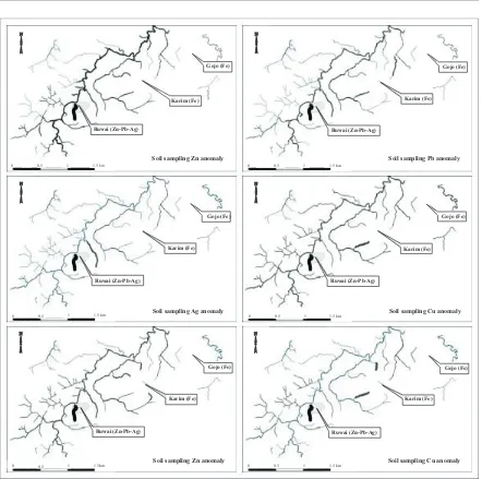
Soil geochemistry results suggest that it is rather difficult to differentiate Zn-Pb-Ag skarn from Fe skarn as both show rela-tively similar anomalies. Anomaly areas are typically wider than known mineralization zones. Even for Cu and Ag anomalies, they tend to have stronger anomalies within Fe skarn rather than Zn-Pb- Ag skarn (Figure 5).
Geophysical surveys
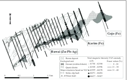
A ground magnetic survey is effective for separating Fe from Zn-Pb-Ag skarn. VLF survey, on the other hand, is effectively
ap-Figure 4. Stream sediment anomalies within the Ruwai area.
Ruwai (Zn-Pb-Ag) Ruwai (Zn-Pb-Ag)
Ruwai (Zn-Pb-Ag) Ruwai (Zn-Pb-Ag) Ruwai (Zn-Pb-Ag) Ruwai (Zn-Pb-Ag)
Karim (Fe) Karim (Fe)
Karim (Fe) Karim (Fe)
Karim (Fe) Karim (Fe)
Gojo (Fe) Gojo (Fe)
Gojo (Fe) Gojo (Fe)
Gojo (Fe) Gojo (Fe)
0 0
0 0
0 0
0.5 0.5
0.5 0.5
0.5 0.5
1 1
1 1
1 1
1.5 km 1.5 km
1.5 km 1.5 km
1.5 km 1.5 km
Soil sampling Cu anomaly Soil sampling Zn anomaly
plied to identify major geologic structures as feeder zones for mineralization (Figure 6). IP
surveys have been conducted twice in mid 1990s (shallow targets) and year 2008 (deep
Figure 5. Soil sample anomalies within the Ruwai area.
Figure 6. Geophysical anomalies based on VLF and ground magnetic surveys.
Ruwai (Zn-Pb-Ag) Ruwai (Zn-Pb-Ag) Ruwai (Zn-Pb-Ag)
Ruwai (Zn-Pb-Ag)
Karim (Fe) Karim (Fe) Karim (Fe)
Karim (Fe)
Gojo (Fe) Gojo (Fe) Gojo (Fe)
Gojo (Fe)
0 0
0 0
0.5 0.5
0.5 0.5
1 1
1 1
1.5 km 1.5 km
1.5 km 1.5 km
Soil sampling Cu anomaly Soil sampling Pb anomaly Soil sampling Zn anomaly
Soil sampling Ag anomaly
0 0.5 1 1.5 km
Gojo (Fe)
Karim (Fe)
Ruwai (Zn-Pb-Ag)
Ruwai deposit Geological unit
Gossan (oxidized skarn) Quartz diorite
Major structures based on VLF Strike-slip fault Thrust fault
Total magnetic Intensity VLF anomaly (nT) Fraser values (%)
41701 - 42584 42585 - 42996 42997 - 44270 44271 - 46656 46657 - 50107
targets). While it is proven effective to indicate iron ore, its effectiveness to dif-ferentiate iron from base metals is yet to be demonstrated.
Alteration
Despite lacking of extensive alteration halos, identification of alteration styles from exposed rocks is important to construct vec-tors to ore. In general, from proximal to dis-tal parts, alteration mineralogy will change following this order: garnet-pyroxene-chlo-rite/epidote-clay. In Ruwai, the shallowest feature of mineralization is present as a fault-controlled argillic zone enveloping a narrower zone of epidote-chlorite and sometimes quartz and/or calcite veinlets. The epidote-chlorite zone with quartz and/ or calcite veinlets at its centre is the main geological evidence for the location of ore-bearing fault at deeper parts.
CONCLUSIONS
At Ruwai, the zoning of skarn mineraliza-tion can be observed centreed from a sub-batholithic intrusion. The proximal zone is dominated by prograde Fe skarn alteration and mineralization, typified by the abun -dance of garnet. Towards the distal parts, alteration consists of both prograde and ret-rograde skarns and mineralization is domi-nated by Zn- Pb-Ag. Best mineralization sites occur when favourable stratigraphic units are emplaced within junctions of sev-eral major faults and folds. Identification of skarn alteration zonation, geologic struc-tures, and near- surface phenomena along the ore-bearing faults are key exploration guides to discover the high grade ore bodies.
ACKNOWLEDGMENTS
The authors thank to the management of PT Kapuas Prima Coal for their permission to present this paper for the Kalimantan metallogeny workshop 2010.
REFERENCES
Carlile, J. C. and Mitchell, A. H. G., 1994. Magmatic arcs and associated gold and copper mineralization in Indonesia. Journal of Geochemical Exploration, 50, p.91-142.
Cooke, D.R. and Kitto, P.A., 1997. Report on the mineral prospectivity of the Tebolai and Schwaner COW’s, southwest Kalimantan, Indonesia. Internal report, 32pp.
Einaudi, M. T., Meinert, L. D., and Newberry, R.J., 1981. Skarn deposits. Economic Geology, 75th Anniversary Volume, p.317-391.
Margono, U., Soejitno, T., and Santosa, T., 1995.
Geological Map of the Tumbangmanjul Quad-rangle, Kalimantan scale 1 : 250.000. Geological Research and Development Centre, Bandung.
Meinert, L. D., 1993. Skarns and skarn deposits.
Geoscience Canada, 19, p.145-162.
PT Scorpion Schwaner Mineral (SSM), 1999. Lapo-ran tentang penciutan pertama wilayah kontrak karya KW POO226 tahap penyelidikan umum, tahun kedua di daerah Ketapang dan Sintang, Kalimantan Barat dan Kotawaringin Barat, Kalimantan Tengah.
Unpublished report.
Taylor, R.G., 1996. Skarn deposits: A practical guide towards rock recognition and structural controls. Notes for training course, Freeport In-donesia.