ITTO PD 73/89 (F,M,I) Phase II
FEASIBILITY STUDY ON REDD+
IN CENTRAL KALIMANTAN INDONESIA
Methodology Design Document
for Reducing Emissions from Deforestation and
Degradation of Undrained Peat Swamp Forests
in Central Kalimantan, Indonesia
IT OT
Bogor, March 2012
ITTO PD 73/89 (F,M,I) Phase II
FEASIBILITY STUDY ON REDD+
IN CENTRAL KALIMANTAN INDONESIA
Sulistyo A. Siran Rumi Naito I Wayan Susi Dharmawan Subarudi Titiek Setyawati
IT OT
Methodology Design Document for Reducing Emissions from Deforestation and Degradation of Undrained Peat Swamp Forests in Central Kalimantan, Indonesia
ISBN: 978-602-7672-14-7
Published by:
Center for Research and Development on Climate Change and Policy Forestry Research and Development Agency (FORDA)
Jalan Gunung Batu No. 5, Bogor 16610 Telp. : 62-251-863 3944 Facs : 62-251-863 4924
Preface
Strengthening effort to mitigate carbon emission have been under taken by many throughout Indonesia, including the Ministry of Forestry no exception. The abatement of greenhouse gas emission program is tailored with the incentive mechanism in reducing emission from deforestation and degradation (REDD+) currently developed by international community. Although such mechanism has gained momentum in global climate change dialogue, nevertheless until the last COP-18 in Dhoha, Qatar, the world community has yet to reach final agreement on the REDD+ implementation.
The opportunity of greenhouse gas abatement through other scheme is now open such as bilateral mechanism which potentially provides a framework to intensify involvement of both public and private sector. Among early initiative are private sector investment and bilateral cooperation program between the governments of Indonesia and developed countries including Japan, Australia, Norway, and Germany.
Currently, Indonesia and Japanese governments develop cooperation to esablish bilateral offset credit mechanism. This mechanism will provide both sides the benefits generated from ativity on GHG emission reduction projet. In order to design credible offset credit mechanism and methodology to be adopted as cooperation framework, both Indonesia and Japan have been jointly undertaking various feasibility studies (FS) on GHG emission reduction projects in Sumatera and Kalimantan.
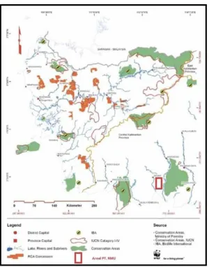
This book called Methodology Design Document (MDD) is one of the finding of FS on REDD+ in Central Kalimantan encompassing an area of 200,000 ha in peat forest ecosystem in Kota Waringin Timur and Katingan, Central Kalimantan. The MDD contains several credible methodologies to be used in measuring and monitoring as well as scrutinizing social and environment safeguard and potential joint offset carbon credit mechanism. More specifically the MDD outlines comprehensive overview of a measurement, reporting and verification (MRV) carbon methodology, social and environment safegard strategies as well as Standard Operation Procedures (SOPs) for field measurements and allometric developmet and verification and developing local allometric equation for tropical peat forest, above and below- ground carbon stock estimation.
Through MDD, both Government of Indonesia and Japan could recognize its credibility, applicability to national standard and adaptability for implementation.
For those who work hard for the MDD completion, it is really appreciated. It is with the hope that this book will provide contribution in the effort of mitigating GHG emission in the country.
Bogor, March 2012
Iman Santoso
Acknowledgement
This Methodology Design Document is the product of a joint feasibility study, commissioned by the Ministry of Economy, Trade and Industry Japan, conducted by Marubeni Corporation, the International Tropical Timber Organization, the Ministry of Forestry Indonesia, Mazars Starling Resources, Terra Global Capital, Hokkaido University and PT. Rimba Makmur Utama.
List of Contents
Preface ... iii
Acknowledgement ... v
List of Contents ... vii
List of Tables ... ix
List of Figures ... xi
Acronyms ... xiii
Introduction ... 1
1. Background ... 1
2. Objectives ... 2
3. Study site ... 2
3.1 Project location ... 2
3.2 Basic physical parameters of the study site ... 4
4. Study Methods ... 5
4.1 Carbon MRV methodology ... 5
4.2 Social safeguards ... 6
4.3 Environmental safeguards ... 7
5. Outputs ... 7
1. Section I: Carbon MRV Methodology ... 9
1.1 Sources ... 9
1.2 Summary Description of the Methodology ... 9
1.3 Definitions ... 13
1.4 Applicability Conditions ... 15
1.5 Project Boundary ... 18
1.6 Procedure for Determining the Baseline Scenario ... 22
1.7 Procedure for Demonstrating Additionality... 22
1.8 Quantification of GHG Emission Reductions and Removals Baseline Emissions ... 24
1.9 Project Emissions ... 54
1.10 Leakage ... 75
1.11 Summary of GHG Emission Reduction and/or Removals ... 79
1.12 Monitoring ... 89
1.13 OtherInformation...112
1.14 Verification Procedure of Allometric Equations ...117
2.1 Stakeholder analysis ...120
2.2 Drivers and agents of deforestation and mitigation measures ...121
2.3 Mitigation measures ...122
2.4 Information, Education and Communication (IEC) Methodology ...124
2.5 Implementation of Free, Prior and Informed Consent (FPIC) processes ...125
2.6 Resource-use and livelihoods patterns ...127
2.7 Benefits distribution ...131
2.8 Monitoring and evaluation of socio-economic impacts ...133
3. Section 3: Environmental Safeguards ...135
3.1 Biodiversity assessment ...136
3.2 Areas with important levels of biodiversity ...136
3.3 Critically endangered species ...138
3.4 Areas that contain habitat for viable populations of endangered, restricted range or protected species ...139
3.5 Specific habitats that are used temporarily by a species or a group of species ...141
3.6 Natural landscapes and dynamics ...143
3.7 Areas that contain two or more contiguous ecosystems...144
3.8 Areas that contain representative populations of most naturally occurring species ...145
3.9 Rare or endangered ecosystems ...147
3.10 Areas or ecosystems important for the provision of water and prevention of floods for downstream communities...149
3.11 Areas important for the prevention of erosion and sedimentation 151 3.12 Identification of threats and potential impacts on biodiversity ...153
3.13 Management strategies to maintain HCVF ...155
References ...159
1. Annex I: Standard Operation Procedure for Field Measurements ...165
2. Annex 2: Standard OperationProcedure for Allometric Development and Verification ...229
3. Annex 3: Local Allometric Equations forTropical Peat Swamp Forests in the Katingan Project Area ...251
4. Annex 4: Aboveground and Belowground Carbon Stock Estimation for the Katingan Project Area ...253
5. Annex 5: Environmental afeguard Strategies for HCV Areas in the Katingan Project area ...259
List of Tables
1. Land systems in the Katingan Project area (Source: Landsystem map,
RePProt) ... 4
2. GHG emissions from sources not related to changes in carbon pools (“emission sources”) to be included in the GHG assessment. ... 19
3. Selected Carbon Pools ... 20
4. Steps to identify conversion strata and examples ... 25
5. Accuracy discounting factors for LULC classification as a function of the smallest attained accuracy across all images used. ... 28
6. Example LULC and forest strata transition table showing all possible transitions. ... 31
7. Contains an example of the subsidence from oxidation and burning as a function of time after conversion and the specific conversion rate. ... 43
8. List of Stakeholders and their role function in the REDD+ Implementation in Central Kalimantan ...120
9. The drivers of deforestation in the Province of Central Kalimantan ...122
10. Potential approaches to handle deforestation and forest degradation ...123
11. Information, Education and Communication strategy and expected outputs. ...124
12. Implementation of FPIC Processes ...126
13. The growth of population in Central Kalimantan ...127
14. Key Sector and number of workers ...127
15. Primary livelihoods at 6 villages surveyed in Kotawaringin Timur and Katingan districts in 2009 and 2012 ...129
16. Biodiversity Richness in Katingan Project area ...140
17. Total ecosystem proxies are deemed to occur within the Katingan Project area ...148
List of Figures
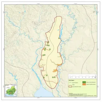
1. The location of the Katingan Project and survey plots ... 3
2. Landuse type in the project Katingan area ...131
3. Katingan Project area between conservation areas ...137
4. Indication of HCV area in Katingan Project Area ...139
5. Indication of HCV area in Katingan Project areas ...141
6. Indication of HCV area of migatory species in Katingan Project Area ...142
7. Indication of HCV area (core and buffer areas) ...144
8. Types of ecosystem in the Katingan Project Areas ...145
9. Primary habitats and sub-habitats inside the Katingan Project area ...147
10. Types of land systems in the Katingan Project area...149
11. Types of ecosystems for watershed provision and protection in the Katingan Project area ...150
12. Hotspots observed from 1993 through 2008 in and around the project area ...152
Acronyms
AFOLU : Agriculture, Forestry, and Other Land Use
ANR : Assisted Natural Regeneration
ARR : Afforestation, Reforestation, and Revegetation
BAU : Business-As-Usual
BOCM : Bilateral Offset Credit Mechanism C : Carbon
CBM : Collaborative Biodiversity Management
CDM : Clean Development Mechanism
Co : Alluvial sediment
CO2 : Carbon dioxide
CP : Conference of the Parties
CR : Critically endangered species
CV : Coefficient of Variation
DBH : Diameter at breast height (1.3 meter)
DF : Deforestation
DG : Forest Degradation
DM : Dry Matter
DNA : Designated National Authority
DNPI : National Council on Climate Change (Dewan Nasional
Peruba-han Iklim)
EF : Emission Factor
ER : Endangered species
ERC : Ecosystem Restoration Concession
FAO : Food and Agriculture Organization
FGD : Focus Group Discussion
FPIC : Free, Prior and Informed Consent
FS : Feasibility Study
GHG : Greenhouse Gas
GIS : Geographic Information System
GPG-LU-LUCF
: Good Practice Guide for Land Use, Land Use Change and Forestry
GPS : Global Positioning System
GWP : Global Warming Potential
Ha : Hectare
HCV : High Conservation Value
HCVF : High Conservation Value Forest
IEC : Information, Education and Communication
IPCC : Intergovernmental Panel on Climate Change
ITTO : International Tropical Timber Organization
IUCN : International Union for Conservation of Nature
LCL : Lower Confidence Limit
LiDAR : Light detection and ranging (an optical remote sensing technology)
LULC : Land Use and Land Cover
LULUCF : Land Use, Land-Use Change and Forestry METI : Ministry of Economy, Trade and Industry Japan MDD : Methodology Design Document
Mg : Mega gram = 1 metric tonne
MMU : Minimum Mapping Unit
MOE : Ministry of Environment Japan MoF : Ministry of Forestry Indonesia
MRV : Measurement, Reporting and Verification MT : Metric Tonne
tCO2e : Metric tonneof Carbon Dioxide equivalent
NDVI : Normalized Difference Vegetation Index
NER : Net Greenhouse Gas Emission Reduction
NGO : Non-Government Organization
NTFP : Non-Timber Forest Products
PD : Project Document
QA/QC : Quality Assurance / Quality Control
REDD+ : Reducing Emissions from Deforestation and Degradation Plus carbon stock enhancement, Carbon Stock Conservation and sustainable forest management
RePProt : Regional Physical Planning Program for Transmigration
SOC : Soil Organic Carbon
SOP : Standard Operation Procedure
TM : Landsat Thematic Mapper
TOd : Dahor formation
UNFCCC : United Nations Framework Convention on Climate Change
VCS : Verified Carbon Standard
Introduction
1. Background
The protection of forests, especially in the tropics and sub-tropics, is an essential part of the international effort to reduce global greenhouse gas (GHG) emissions and stabilize the global climate system. Previous research suggests that approximately 20% of global GHG emissions are attributed to the forestry sector, and a 50% reduction in deforestation is needed by 2030 if the forestry sector is to effectively support collective efforts to halt global temperature rise at below 2 degrees Celsius. Given this background, reducing emissions from deforestation and forest degradation (REDD+)has gained momentum in global climate change dialogues, as it provides a framework to incentivize both public and private sectors to reduce GHG emissions, enhance carbon stocks and promote sustainable forest management in developing countries such as Indonesia.
In 2005, as much as 85% of the total GHG emissions in Indonesia resulted from land use, land-use change and forestry (LULUCF) and peatland, of which emissions from carbon-rich peatlands amounted to 41% (DNPI, 2010). Indonesia has a projected abatement potential of 1,770 million tons of CO2
equivalent (MtCO2e)from the LULUCF sector and peatlands when compared
with its business-as-usual (BAU) emissions of 3,260 MtCO2e in 2030 (DNPI, 2010).The 26-41% GHG emission reduction commitment announced by President Susilo Bambang Yudhoyono in 2009 and these abatement potentials have triggered a number of multi-stakeholder initiatives and REDD+ financing outside the United Nations Framework Convention on Climate Change (UNFCCC) framework. These include private sector investment and bilateral cooperation programs between the Governments of Indonesia and developed countries including Japan, Norway, Australia, Germany, the UK and the USA.
Followed by the pre-feasibility study projects undertaken by the METI in 2010, the METI continued its support by scrutinizing BOCMs which are to be considered under the future bilateral cooperation between the Government of Japan and the government of Indonesia. For the fiscal year 2011, the METI commissioned three REDD+ related projects for Indonesia, of which Marubeni Corporation undertook a comprehensive REDD+ feasibility study in Central Kalimantan (REDD+ FS 2011). This REDD+ FS 2011was jointly implemented from October 2011 to February 2012 by a consortium of institutions – namely, the Ministry of Forestry Indonesia, Mazars Starling Resources, Terra Global Capital and Hokkaido University, in cooperation with Marubeni Corporation and International Tropical Timber Organization.
2. Objectives
In the absence of a globally accredited methodology to measure, monitor and verify GHG emission reductions under the UNFCCC umbrella, there is a need to establish a BOCM, in which both Governments of Japan and Indonesia may recognize its credibility, applicability to national standards and adaptability for implementation.
Thus, this Methodology Design Document (MDD) was created to provide a comprehensive overview of a measurement, reporting and verification (MRV) carbon methodology used for the Katingan Peatland Restoration and Conservation project. The METI will review this methodology along with others as it develops a common methodology under the BOCM to foster the development of REDD+ projects in Indonesia that deliver credible and robust GHG emission reductions while safeguarding community and biodiversity benefits. The social and environmental safeguard review sections in this report describe the approaches employed by the Katingan Project, as opposed to generic methodologies.
3. Study site
3.1 Project location
million ha are protection forests. The province encompasses 3 million ha of peatlands.
The Katingan Project is a REDD+ project managed through an ecosystem restoration concession (ERC) model, one of the land-use permits issued by the Government of Indonesia. PT. Rimba Makmur Utama, a Jakarta based project developer, is the prospective concession holder and aims to restore and conserve 217,755 hectares of peat swamp forest inside the project boundary. The Katingan Project also seeks to promote sustainable forest management and develop alternative livelihoods of the surrounding communities.
3.2 Basic physical parameters of the study site
3.2.1 Soils
Two formations make up the geological characteristic of the Katingan Project area i.e.,: Alluvial sediment (Co) and Dahor formation (TQd). Most of the soils in the area are considered Organosol glei humus. The soil is characterized as peat, which is naturally acidic at pH levels between 3.0 and 5.0, and is composed of the high accumulation of organic matter substances such as partly decomposed leaves and tree stems. The formation of peat soil in the proposed concession area is a result of constant conditions of water logging above mineral soil and a lack of oxygen, in which a large amount of organic residues are decomposed, forming a peat layer.
3.2.2 Land cover
The Katingan Project area is mostly a peatland, a large part of which is still covered with peat swamp forest. It is characterized by flat terrain with a slope angle of 0-8%, at an altitude of 0-30 meters above sea level. According to a study conducted by the Regional Physical Planning Program for Transmigration1 (RePProt), there are three forest ecosystem proxies within the proposed concession area – peat forest, heath forest and fresh water swamp forest. (see Table 1).
Table 1. Land systems in the Katingan Project area (Source: Landsystem map, RePProt)
ECOSYSTEM Land System RePPProT Size (Ha)
Peat Forest Barah, Gambut, Mendawai 207,921
Fresh Water Swamp Forest Kahayan, Sebangau, Klaru 5,220
Heath Forest Pakau, Segintung 4,614
TOTAL 217,755
Three land cover classes exist in the proposed restoration (i.e., non-forested land, disturbed peat swamp forests and primary peat swamp forests). Small part of non-forest land occurs in the southern part, while disturbed peat-swamp forest extends mostly in the periphery of the proposed restoration.
The large part of the primary peat swamp forest stretches from the north to the south in the center of the Katingan Project area.
3.2.3 Rainfall
Average monthly rainfall in the proposed concession is estimated at 240 mm per month with total annual rainfall equal to 2,881 mm per year. Rainfall is relatively evenly distributed throughout the year with all months reportedly receiving more than 200 mm of rain. June through October are generally the driest months, while the wettest months occur in November through May with the average monthly rainfall rises up to 303 mm per month.
3.2.4 Hydrology
The total area of the Katingan Project area is 217,755 ha, which falls between the Mentaya and Katingan Rivers. The flood plains of the two major rivers extend only a short distance from the river banks into forests. Thus, the entire project area receives little nutrient influx from these river floodplains and therefore can be classified as an “ombrogenous” peat swamp. In ombrogenous peat swamps, the only source of nutrient influx is from aerial precipitation (i.e., rain and dust), with small amounts of nutrient influx through microbial nitrogen fixation and faunal migration/animal faeces (Sulistiyanto, 2004).
4. Study Methods
This Methodology Design Document was developed using existing MRV methodologies, reports and literature, as well as field survey results. The below sections describe methods applied to conduct the FS activities and field surveys.
4.1 Carbon MRV methodology
In developing and testing a carbon MRV methodology and monitoring plans, the FS team reviewed and refined existing methodologies, including:
1. Standard operation procedure (SOP) for field measurements2;
2. SOP for allometric equation development and verification3; and
3. Verified Carbon Standard (VCS) methodology for peat swamp forests4.
2] Smith E. M., Gryze S.D., Kusumaatmadja R., Darusman T., and Hardiono M. (2011). 3] Sharma B., Gryze S. D., Smith E. M., Silverman J. (2011).
The carbon MRV methodology was further tested and developed through field surveys, including:
1. Aboveground forest biomass inventory (aboveground carbon stock measurement) inside 9 nested sampling plots covering 3 forest strata – primary forest5, secondary forest after logging (also denoted as logged-over forest) and secondary forest after forest fires (also fire-damaged/ burnt forest);
2. Destructive sampling inside all 9 nested sampling plots to develop a localized allometric equation;
3. Peat survey (belowground carbon stock measurement) at 17 sampling points (9 points inside the nested sampling plots and 8 points along two 1-km line transects);
4. Water level measurement at 17 sampling points using an electric contact meter, and at 2 additional sampling points in logged-over and burnt forest using a HOBO automatic water level recorder6.
Finally, samples and data collected during field surveys were analyzed at a laboratory to estimate aboveground and belowground carbon stocks. Furthermore, to integrate the field survey results into a carbon stock map and stratify forest types, the FS team conducted a remote sensing analysis by using Landsat Thematic Mapper (TM) 5. Survey results and refined SOPs are available in appendices.
4.2 Social safeguards
A social safeguards study was conducted through literature reviews and a field survey in 4 villages in Kotawaringin Timur district located nearby the Katingan Project site.
4.2.1 Data collection
4.2.2 Data analysis
Data collected through the FGDs was analyzed in reference to the literature, relevant Indonesian laws and regulations, and previous reports produced under the pre-feasibility study for the fiscal year 2010.
4.2.3 Logical framework
A logical framework was used to review drivers of deforestation and its impacts on peatland forest and local communities’ livelihoods.
4.3 Environmental safeguards
An environmental safeguards study was conducted through a rapid assessment of high conservation value (HCV) species identified in the Katingan Project site.
4.3.1 Field survey
A field survey was conducted in sampling plots along 9 line transects. The sample plots were established based on the local variation of vegetation types within peat swamp ecosystems, levels of disturbance and faunal concentration of rare, threatened and endangered species. At each sample site, the FS team measured and recorded all trees with a diameter at breast height (DBH) greater than 10 cm, identified local species names, and collected leaf samples for a laboratory analysis.
4.3.2 HCV rapid assessment
Based on the high conservation value forest (HCVF) identification toolkit for Indonesia7,Starling Resources’ earlier faunal8 and floral9 reports, and the evaluation of secondary data, the FS team conducted a rapid HCV assessment for the biodiversity components, HCV 1, 2 and 3, to identify the existence of HCV species and prominent threats to them, as well as to produce indicative maps of the area’s forest land systems and HCV species.
5. Outputs
The Methodology Design Document is comprised of three sections – carbon MRV methodology, social safeguards and environmental safeguards,
each providing methodologies, approaches and/or recommendations. These were designed as an appropriate means to implementing REDD+ projects in Indonesia under a bilateral corporation mechanism, and carefully reviewed and recommended by the FS team. Furthermore, supplementing documents are provided in the annexes, including:
1. A refined SOP for field measurements;
2. A refined SOP for allometric equation development and verification; 3. Allometric equations for tropical peat swamp forests in the Katingan
Project area;
4. Aboveground and belowground carbon stock estimation for the Katingan Project;
5. Environmental safeguard strategies for HCV areas in the Katingan Project area; and
6. Recommendations for next steps after the REDD+ FS 2011.
Section I: Carbon MRV
Methodology
1.1 Sources
This methodology uses different elements from several approved methodologies and tools. More specifically, this methodology is based on elements from the following methodologies (latest version):
1. Approved CDM Methodology - AR ACM0001 Afforestation and reforestation of degraded land
2. Approved CDM Methodology - AR AM0006 Afforestation/Reforestation with Trees Supported by Shrubs on Degraded Land
This methodology also refers to the latest approved versions of the following tools or modules:
1. VT0001 Tool for the Demonstration and Assessment of Additionality in VCS Agriculture, Forestry and Other Land Use (AFOLU) Project Activities. (Available at http://www.v-c-s.org/tool_VT0001.html)
2. AR AM Tool 03 Calculation of the number of sample plots for measurements within A/R CDM project activities. (Available at https://cdm.unfccc.int/ methodologies/ARmethodologies/tools/ar-am-tool-03-v2.pdf
3. Approved VCS Module VMD0014 “Estimation of emissions from fossil fuel combustion (E-FFC)” (Available at http://www.v-c-s.org/methodologies/
VMD0014)
Projects that meet the applicability criteria of this methodology will conform to all relevant applicability criteria associated with each of these individual methodologies and tools.
1.2 Summary Description of the Methodology
conversion methodology. More specifically, this methodology offers more flexibility in estimating the baseline deforestation rates, includes a procedure to apply hierarchical forest transition to model the conversion process, uses geostatistical techniques to interpolate peat depths between sampling points, and allows for some small-scale deforestation and forest to be present in the project area. Furthermore, this methodology is developed to be compatible with the new VCS PRC guidelines and uses an internationally accepted definition of peat i.e., containing minimum of 30% organic matters and depth of at least 30 cm (as defined by the Internal Peat Society). The main methodological aspects of the methodology are:
1. The project area must be a production forest i.e. forest land designated for production purposes.
2. Baseline emissions in the project area are calculated based on either legally approved conversion rates or empirically measured historical deforestation rates observed in a reference region similar to the project area.
3. Emissions from non-peat carbon stock densities are quantified by subtracting carbon densities under the project and baseline scenario. Carbon densities for non-peat components are quantified on permanent sampling plots on forest lands or temporary sampling plots on non-forest
lands. Emissions from peat carbon stock densities are quantified
by measuring or extrapolating the difference in water table and peat subsidence between the project and baseline scenarios. The total net emission reductions are discounted based on the attained precision of biomass, water table, and peat subsidence measurements. If the emissions cannot be measured with sufficient precision, the project is not eligible. 4. Potential emissions from primary leakage are monitored and quantified
using a leakage belt approach. Market-effect leakage must be accounted for within each PD, according to the rules set forward within the VCS guidance.
5. While assisted reforestation is not allowed under the VCS AFOLU guidance for REDD projects, natural reforestation and regeneration must be included in the baseline and project scenarios. This is achieved by applying the empirically observed baseline regeneration and reforestation rates in the reference region to the project and baseline scenarios.
procedure than for the quantification of GHG benefits from areas without assisted natural regeneration.
7. The methodology is not applicable to grouped projects. However, the project may contain multiple non-contiguous areas. The procedure to account for this is described in section 1.8.1 Describe Spatial Boundaries of the Discrete Project Area Parcels.
1.2.1 Summary of Major Methodological Steps for the Baseline GHG Emissions, Project GHG Emissions, and Monitoring
The PD contains the ex-ante annual net GHG emission reductions due to
project activities (NERs) and an estimate of the ex-ante VCUs that are issued after transferring a portion of the NERs to the buffer pool according to the buffer withholding percentage. The actual NERs and VCUs are calculated ex-post based on data collected during monitoring and reported in a monitoring report. The calculation of emission reductions is based on the following principles:
1. This methodology separates emission reductions from avoided deforestation, emission reductions from avoided peat conversion, and carbon uptake through assisted natural regeneration (ANR) because different carbon accounting methods, accuracy thresholds and discounting procedures are applicable on each of these sources:
a. The calculation of non-peat related emission reductions from avoiding deforestation is based on a classification and stratification of the land in discrete classes or forest strata according to the land use and land cover (LULC) or forest type and density. By analyzing transitions from forest classes to non-forest classes, the emissions related to deforestation can be quantified.
b. The calculation of emission reductions from avoided peat
conversion is based on (1) measurements of the water table in the project area, and (2) the expected drainage level under project scenario. c. The accounting for greenhouse gas benefits from assisted natural
regeneration (ANR) activities are calculated completely separated using the most recent version of the approved consolidated CDM methodology AR-ACM0001: “Afforestation and Reforestation of Degraded Land”.
2. Significant methane, nitrous oxide and fuel-CO2 emissions from project and community development activities must be subtracted from the NERs. 3. The project must implement activities to minimize any potential emissions
project area. Only significant emissions need to be retained in the final calculations.
1.2.1.1 GHG Sinks and Emissions under the Baseline Scenario
Under this methodology, the most plausible baseline scenario under the CDM modalities and procedures, paragraph 22 is option (c). The calculation of the emissions from deforestation in the project area under the baseline scenario is based on a combination of (1) forest conversion rates from legally recognized documents, or forest conversion rates from a historical remote sensing analysis, (2) biomass inventories to measure the emissions of the non-peat carbon pools after the project area would have been converted, and (3) measurements of the peat depth in the project area and the depth of the water table after conversion to quantify the emissions from the peat carbon pool.
1.2.1.2 GHG Emissions and Sinks under the Project Scenario in the Project Area
For the ex-ante calculations of the project’s GHG emissions, it is assumed that under the project scenario, (1) no conversion takes place inside the project area, but selective logging is allowed under certain applicability criteria, (2) no change in biomass density occurs, apart from areas where sustainable logging is taking place and areas where assisted natural regeneration is performed, and (3) no changes in water table occur. In case the project area is located in Indonesia and the project area is protected by an ecosystem restoration license, logging is not allowed. The carbon accounting for the areas on which assisted natural regeneration activities take place must follow the latest version of approved CDM methodology AR-ACM0001.
1.2.1.3 GHG Emissions under the Project Scenario outside the Project Area (Leakage)
1.2.1.4 Monitoring Methodology
During the crediting period, all data and parameters that are included in the monitoring tables further in this document must be recorded with the frequency specified. Monitoring has four components: (1) measuring the forest conversion rate within the project area, (2) measuring carbon stock densities per LULC class using field sampling techniques and, (3) measuring the peat depth and the depth of the water table, (4) tracking all GHG emissions from emission sources and (4) monitoring the forest conversion rate outside of the project area by the pre-project deforestation agents.
1.3 Definitions
The definitions below are consistent with or complement the definitions in the VCS AFOLU Requirements. The definitions contained in the Program Definitions document from the VCS shall always have precedence over the definitions introduced in this section.
1.3.1 Definitions Regarding Geographical and Temporal Boundaries
1. The project area is the geographical area where the project participants will implement activities to reduce deforestation. The project area may be contiguous or consist of multiple smaller adjacent and non-adjacent
project areas (referred to as discrete project area parcels) and
conforms to the definition of “forest” set forward by the VCS Program Definitions.
2. The reference region is the region from which historical land-use change trends are obtained. This information is required to the evolution of future land-use change in the absence of project activities (i.e. baseline scenario). Before the start of the project (i.e. during the historical reference period) the reference region includes the project and leakage areas. After the project has started (i.e. during the crediting period) the reference region excludes the project and leakage areas to serve as a reference for determining deforestation and forest degradation rates in the absence of project activities.
1.3.2 Definitions Regarding Classification and Transition of Land Use and Land Cover
1. In this methodology, units of land are allocated to different land use and land cover (LULC) classes. The LULC classification system must be hierarchical in nature. At the highest level, the definitions from the IPCC GPG-LULCF 2003 for cropland, grassland, settlement, wetland and other land must be followed. A definition of “forest” is included in the VCS Program Definitions.
2. A forest LULC class may be further divided into forest strata according to the carbon stock density, native forest type, past and future management, landscape position, biophysical properties, and the degree of past disturbance. The minimum mapping unit set forward in the forest definition must also be applied to forest strata. The process of sub-dividing the broad forest LULC class into more narrow forest strata is defined as forest stratification.
3. A land transition is a change from one LULC class or forest stratum into another within one geographical area. This methodology considers four main categories of transitions.
a. Forest regeneration (RG) is the persistent increase of canopy cover and/or carbon stocks in an existing forest due to natural succession or human intervention, and falls under the IPCC 2003 Good Practice Guidance land category of forest remaining forest.
b. Increased forest cover is the transition of non-forest land into forest land, and encompasses both reforestation and natural succession. 4. Reforestation (RF) is the human-induced increase in forest cover (e.g.,
from cropland to forest, or grassland to forest), and is defined in the VCS Program Definitions.
5. Natural succession is a natural increase in forest cover without any human intervention. Natural succession is included in the baseline and project scenarios. Natural succession and increase in forest cover are likely results of decrease in deforestation rate due to project activities.
1.3.3 Other definitions relevant within the scope of this methodology
1. Peat is organic soil with at least 30% organic matter and a minimum thickness of 30 cm.
peat swamp forest is then defined as land qualifying as forest located on tropical peat swamp.
3. Timber harvesting for local and domestic use. The extraction of timber wood for direct use within the project area and by the households that are living within the project area, without on-sale of the timber 4. Commercial timber harvesting. The extraction of timber wood for
further sale on regional/global timber markets outside of the project area or transferred to non-project participants.
5. Participating community. A local community of individuals and households who are permanently living adjacent to the project area, and who are participating in project activities and directly benefit from project activities through increased livelihoods and improved forest resources. 6. Assisted natural regeneration. Any silvicultural activity that accelerates
regeneration over natural regeneration rates. Examples of such activities include thinning to stimulate tree growth, removal of invasive species, coppicing, and enrichment planting.
7. A production forest is a forest used for production of various
commodities, including timber.
8. A jurisdiction is the legislative territory where power to govern or legislate permits for land and forest concessions is exercised.
1.4 Applicability Conditions
Project proponents must demonstrate that project conditions meet the following list of criteria. Note that in case the project area consists of multiple discrete project parcels, each discrete parcel must meet all applicability criteria of this methodology.
Criteria related to conditions on the land before project implementation: 1. Land in the project area (a) is in the tropical region, (b) qualifies as a
forest for at least 10 years before the project start date, and (c) must be a natural forest but may be in a state of partial degradation caused by one or more of the following (legally sanctioned or illegal) drivers of deforestation/degradation:
a. Conversion of forest patches to settlements
b. Conversion of forest patches by households for small-scale cropping (excludes commercial agriculture)
d. Collection of fuel-wood or green wood for charcoal production e. Commercial timber harvesting
This methodology takes into consideration that peat swamp forests may be under a dual threat by (1) planned conversion by corporate entities, but also (2) small-scale deforestation from e.g., settlements, conversion for subsistence farming, rubber tapping, and small-scale logging. This methodology provides guidance and procedures to manage such small scale deforestation drivers.
2. The project area is (1) legally designated as forest that can be converted to non-forest or production forest with lower biomass than the original forest by all relevant regional and national authorities, and (2) effectively at threat of conversion as demonstrated by either (2a) sufficient and necessary permit(s) to legally convert the project area by an identified agent of deforestation or (2b) the existence of three conversion permits on other areas within the union of a 250-km buffer around the project area and the jurisdiction with decision-making authority on concession permitting.
3. The baseline rate of conversion of the project area can be quantified as following, separately for each of the conversion strata10, (subsequent options may only be used if prior options are not applicable).
a. If the project proponent can produce documentary evidence that demonstrates a legally approved conversion rate by an identified agent of deforestation, this rate must be used in the carbon accounting for the project. The document used must have all necessary legal approvals and permits.
b. If no such documentary evidence exists, or no specific deforestation agent can be identified, the rate of conversion by the most likely deforestation agent can be determined based on the historical conversion rate by this most-likely deforestation agent in an area similar to the project area (“reference region”). The reference region must consist of at least three areas under the same conversion stratum as the project area within the union of a 250-km buffer around the project area and the jurisdiction with decision-making authority on concession permitting.
older than 10 years, (iii) and is from the same country. Section 1.8.2.3 contains further procedures to verify these conditions.
Criteria related to conditions on the land after project implementation:
4. Project proponents shall demonstrate that they have planned conservation activities so that the threat of conversion is reduced. A description of the conservation activities must be presented at every verification.
5. If one or more of the degradation drivers outlined in Applicability Criterion 1 have been active in the past five years in the project area, one or more of the following project activities must be implemented, designed in collaboration with the local communities.
a. Supporting alternative livelihood options targeting the communities active in the forest
b. Forest patrolling activities c. Fire controls
d. Supporting the use of fuel-efficient stoves e. Establishment of sustainable fuel-wood lots f. Agricultural intensification.
6. Development of new drainage or continuation/maintenance of active drainage canals within the project boundary is not eligible.
7. If the area that is hydrologically connected to the project area in which peat is present extends beyond the project area boundary, it is required to establish a buffer zone around the project area with peat. It must be ensured that no draining occurs in this buffer zone. It is allowed that the buffer zone extends beyond the project area boundary if legally binding agreements are put in place with land owners of the land outside the project area to ensure that no draining occurs in the buffer zone. However, if such agreements cannot be established, the buffer zone must be established inside the project boundary. In the event that land owners in the buffer zone violate the agreement and begin drainage activities in the buffer zone, the buffer zone shall be immediately redrawn inside the project boundary and credits shall be calculated using the updated buffer zone from the moment the violation occurs and impacts emissions in the project area. The width of the buffer zone must be established using the procedures in Section 1.8.1.
a. The emissions related to the loss of biomass during harvesting (“harvest emissions”) are duly accounted for and subtracted from the emission reductions.
b. For every verification period, the harvest emissions are smaller than the net emission reductions without harvesting generated during that verification period, so that no “negative credits” are generated.
c. Selective harvesting shall not significantly affect the hydrology of the peat layer and cause peat decomposition. Harvest activities do not require the development or maintenance of drainage canals in the project area
d. In case the project area is located in Indonesia, the project area shall not be protected by an ecosystem restoration license.
9. The magnitude of activity-shifting leakage by communities present within the project area or using the project area is quantified through a rigorous monitoring plan consisting of rural appraisals, remote sensing analysis and biomass inventories in the project area and all leakage belts11. The exact procedures for doing so are included in this methodology.
Other criteria:
10. Subsequent to the removal or disappearance of carbon in the above ground live biomass pool, carbon in the below ground biomass pool is also removed or disappears within the duration of the project. The removal of the belowground biomass can be caused by anthropogenic activities such as digging, extraction of stump, and burning, or by the natural process of decay and decomposition12.
11. The maximum quantity of GHG emission reduction claimed by the implemented project from peat component shall not exceed the net GHG benefits generated by the project 100 years after the start date. This condition must be verified using the procedures in Section 1.11.4.
1.5 Project Boundary
1.5.1 Gases
in carbon pools, henceforward referred to as “emission sources” (Table C1)13. Project proponents may omit certain emission sources, but only if they can prove that their contributions are insignificant. The VCS defines significant sources as those accounting for more than 5% of the total GHG benefits generated.
Table 2. GHG emissions from sources not related to changes in carbon pools (“emission sources”) to be included in the GHG assessment.
Potential
Emis-CO2 No Emissions are related to changes in carbon pools CH4 No Negligible
N2O No N2O emissions from fire are conservatively ex-cluded.
Burning of peat
CO2 Yes Emissions are related to changes in carbon pools
CH4 Yes Major source of emissions under the baseline scenario
N2O No Major source of emissions under the baseline
scenario Peat
oxida-tion from drainage
CO2 Yes Major source of emissions under the baseline scenario
CH4 No Negligible
N2O No Negligible
Pr
CO2 No Not applicable
CH4 Yes Potentially major source
N2O No Not applicable Increased
CO2 No Not applicable CH4 No Not applicable
N2O Yes Potentially major source
Removal
CO2 Yes Potentially major source
CH4 Yes Potentially major sourceif controlled burning is used N2O No N2O emissions from burning are insignificant
1.5.2 Carbon Pools
Table 2 summarizes the carbon pools that must be included in projects following this methodology.
Table 3. Selected Carbon Pools
Carbon Pool Included? Justification/ Explanation of Choice
Above-ground tree biomass
Included Major carbon pool affected by project activities
Above-ground non-tree biomass
Included Change expected to be positive or insignificant under the applicability criteria.
Below-ground biomass Included Major carbon pool affected by project activities Dead wood Included Major carbon pool affected by project activities
Litter Included Potentially significant carbon pool.
Soil organic carbon (including peat)
Included Major carbon pool affected by project activities
Long-lived Wood products
Included Logging may have been present under baseline conditions. Therefore, halting logging may decrease carbon stored in long-lived wood products.
1.5.3 Spatial and Temporal Boundaries
The spatial boundaries of the project area must be unambiguously defined in the PD. The project area may be contiguous or consist of multiple adjacent or non-adjacent parcels, “discrete project area parcels”. Around each discrete project area parcel, a leakage belt shall be defined. Before the start of the project, the reference region must include the project area and leakage area. After the start of the project, the reference region may not contain the project area and leakage belt.
Create a buffer boundary at a nominal distance from the peat area within the project
area
Simulate the impact of a canal located at the buffer boundary on the emissions in the project
area
Are emissions greater than de minimis (cfr.VCS AFOLU Requirements 4.3.3?
Buffer area is area that is hydrologically connected to project
area.
Yes
No
Expand buffer area with nominal value
An example of a sufficient hydrological model is SimGro14, which utilizes the Modflow model in the backend; an example of how SimGro is applied for peat swamp forests in Indonesia is provided in Wösten et al. (2008). Project proponents must duly record all procedures used to delineate the area of hydrological connectivity in the Project Document.
Project duration is fixed and must be a minimum of 20 years and a maximum of 100 years and is renewable at most four times with total project crediting period not exceeding 100 years as specified in the latest version of the VCS Program Documents.
Reporting requirements in the PD
1. Evidence that each of the applicability conditions is met.
2. The project location description as required by the VCS Program Documents.
3. A list of specific sources of greenhouse gases that will be considered in the project based on Table 1.
1.6 Procedure for Determining the Baseline Scenario
The most current version of the VCS “VT0001 Tool for the Demonstration and Assessment of Additionality in VCS Agriculture, Forestry and Other Land Use (AFOLU) Project Activities” must be used to determine the most likely baseline scenario.1.7 Procedure for Demonstrating Additionality
The most current version of the VCS “VT0001 Tool for the Demonstration and Assessment of Additionality in VCS Agriculture, Forestry and Other Land Use (AFOLU) Project Activities” must be used to determine additionality.
PD Reporting requirements
1. Demonstration on how the project is additional using the additionality tools from the VCS.
The most current version of the VCS “VT0001 Tool for the Demonstration and Assessment of Additionality in VCS Agriculture, Forestry and Other Land Use (AFOLU) Project Activities” must be used to determine the most likely baseline scenario. The procedures described in VCS tool VT0001 must be followed to identify and analyze the alternative baselines. The most plausible baseline must be selected from the list of available alternative baselines using the step-wise approach below. The selected baseline shall be planned conversion to a non-forest land use. The areas or strata where the most plausible baseline scenario is not the planned conversion of forest to non-forest land-use shall be excluded from the project area. The following steps must be repeated for each of the strata of the project area to justify the selected baseline scenario:
must be described by providing a detailed account of accessibility to relevant markets for the goods and services derived from project area, and suitability of soils, topography and climate for intended conversion. Exclude any areas that were found to be unsuitable for non-forest land-uses from the project.
2. For all the areas that were found to be suitable for conversion to non-forest land-use, enumerate and describe all the possible agents of planned forest deforestation in the region. An agent of the planned deforestation can be either the land-owner, or the right holder.
a. If a specific agent of deforestation can be identified, it must be demonstrated that this specific agents of planned deforestation is likely to proceed with conversion within the project credit period in absence of AFOLU project. The likelihood of deforestation by the specific agent of deforestation must be demonstrated by providing documentary evidence that demonstrates legally approved conversion by the identified agent of deforestation. The evidence used may be one or more of the following:
• Valid forest conversion license owned by agent of deforestation. • Documentation that a request for approval for forest conversion
has been filed with the tenure holder and relevant government department, if applicable.
• Documentation that provides evidence of landowner investment to establish suitability of project lands to proposed post-deforestation land use.
• Record of planned deforestation activities of agents in the past 10 years in the country.
• Purchase offer of the project area by an entity to convert the land to non-forest land-use
• Bid for conversion announced by the land-owner.
b. If no specific agent of deforestation can be identified, the likelihood of deforestation must be demonstrated through the existence of three conversion permits on other areas within the union of a 250-km buffer around the project area and the jurisdiction with decision-making authority on concession permitting.
4. Provide a description of the planned conversion activities of the most plausible agent of planned deforestation in areas similar to the project area. If the most likely agent can be specifically identified but has never converted areas similar to project area, then project proponents must demonstrate that it is indeed likely that such conversion may take place in absence of the project activity. The propensity of conversion can be demonstrated by providing a verifiable description of conversions taking place within the jurisdictions such as province, state or region within the past 10 years. The descriptions could be augmented with relevant documents, images and maps, if available. Verifiable historic account of such conversion may come from several sources including scientific publications based on primary data using social assessment, government records, remote sensing assessments and management plans.
1.8 Quantification of GHG Emission Reductions and
RemovalsBaseline Emissions
1.8.1 Select Spatial and Temporal Boundaries
This step includes the demarcation the project area and the reference region.
1.8.1.1 Describe Spatial Boundaries of the Discrete Project Area Parcels
Project proponents shall provide digital (vector-based) files of the discrete project area parcels Keyhole Markup Language (KML) file format as required by VCS. A clear description must accompany each file, and the metadata must contain all necessary projection reference data. In addition, the PD must include a table containing the name of each discrete project area parcel, the centroidcoordinate (latitude and longitude using a WGS1984 datum), thetotal landarea in ha, details of tenure/ ownership/zoning and the relevant administrative unit belongs to (county, province, municipality, prefecture, etc.).
1.8.1.2 Stratify Each Unique Project Parcel According to Potential Conversion Scenario
practice.Identify the most relevant conversion scenarios that may be present on the land while taking into account any legal limits and requirements for the conversion.
Table 4. Steps to identify conversion strata and examples
Sub-step Example
1. Identify the different legal zoning categories of the project area.
In Indonesia, forest land can be sanc-tioned in many ways. Production forest land can be sanctioned as HP (“Hutan Produksi”) or HPK (“Hutan Produksi Konversi”) according to In-donesian law.
2. For each of the legal zoning cat-egories, identify the most likely conversions based on (1) previous official applications of concessions, or (2) previous active concessions on the forest land, or (3) com-mon practice in the area 250 km around the project area
HP land is gradually degraded and converted into HPK
HPK land is converted into oil palm plantation
3. Identify potential legal constraints of the conversions
Conversion of palm oil may only be done on areas that are not riparian and that have less than 3 m of peat. Land clearance through burning for plantation establishment is illegal in Indonesia.
4. Demonstrate that the land con-versions identified are truly pos-sible according to biophysical con-straints or legal concon-straints.
Conversion of palm oil cannot be done on sloping terrain or on high-clay soils.
Combine the four sub-steps of Table C3 into discrete “conversion strata” such as:
1. Conversion to oil palm plantations on HPK land
2. Degradation of peat land immediately adjacent to oil palm plantations 3. Logging of merchantable timber (if logging is allowed in the project area)
1.8.1.3 Specify Temporal Boundaries of the Project
Project proponents must fix the following temporal boundaries:
1. The historical reference period with exact start date. The end of the historical reference period must coincide with the project start date. The duration of the historical reference period must be between 6 and 10 years.
2. The project crediting period with exact start date and project end date. The start of the crediting period is equal to the start of project date and is the date when the first project activity for which NERs are claimed is implemented. The duration of the crediting period must be between 20 and 100 years.
3. Project proponents must seek third-party verification at least every five years. The frequency of verification may change during the crediting period (e.g., every two years during the first ten years of the crediting period, and every five years thereafter). The frequency and years of verification must be fixed for the duration the baseline is valid and must be included in the PD or in a monitoring report if the baseline is updated.
Baselines must be updated at year five, ten and every ten years thereafter. Under specific circumstances, the baseline must be updated more frequently. These circumstances are outlined in the monitoring section.
Reporting Requirements in the PD
1. Maps for all project areas with the LULC classes and forest stratification. 2. Shape files of the discrete project area parcels and the reference region1.
All necessary meta-data to correctly display the files must be included. 3. Table of all the discrete project area parcels with their ID, name,
coordi-nate centroid (latitude and longitude using a WGS1984 datum), total land area in ha, details of tenure/ownership, and the relevant administrative unit. 4. Overview map of the whole reference region with the location of the
discrete project area parcels clearly indicated.
1.8.2 Determine Baseline Conversion Rates
applicable. Different conversion strata within one project may use different options to determine the baseline conversion rate.
1.8.2.1 Option (a) - Legally Approved Conversion Rate
If the project proponent can produce documentary evidence that demonstrates a legally approved conversion rate for the project area by an identified agent of deforestation, this rate must be used in the carbon accounting for the project. Examples of such evidence include legally approved management plans, management maps, etc. The documents provided as evidence used must have all necessary legal approvals and permits. However, the permits may not be valid any longer due to the existence of the REDD project.
1.8.2.2 Option (b) – Historical Conversion Analysis in a Reference Region
In case no legally recognized forest conversion rate is available, the rate of deforestation and forest degradation in the project area under the baseline scenario may be calculated from the reference region which is used as a proxy for the baseline calculations within the project area. The reference region consists of at least three areas that have a similar land conversion stratum as the ones identified in the project area, but on which the conversion has already occurred in the reference region that includes a 250-km buffer around the project boundary and the jurisdictional area. The quantification of the conversion rate shall only be based on the land that is legally allowed to be converted using current legal restrictions, even if such restrictions were not into force at the time the historical conversion occurred. Land that has been converted but is not allowed to be convert according to current legal restrictions shall be excluded from the conversion rate calculation.
must be used if they are accurate enough for project-specific classification. All steps involved in pre-processing (e.g., orthorectification, cloud masking, haze removal, radiometric corrections), classification (e.g., (sub-)pixel based or segment-based), and post-processing (e.g., spatial and temporal filtering) must be duly noted in the PD. In addition, an independent accuracy analysis must be included. The accuracy assessment of the LULC classification and forest stratification process must follow the best practices for remote sensing (e.g., Congalton 1991). The LULC classes or forest strata for these reference locations must be identified using field observations, in-situ maps, remote sensing data, and other ground-truthing data. At least 50 reference locations per LULC class or forest stratum must be used. More specifically, the classification accuracy must be assessed by comparing the classes of the points from the validation dataset with the classes of the same locations on the classification products. A confusion matrix or error matrix will be produced together with different statistical measures of overall accuracy, producer’s accuracy, user’s accuracy and kappa statistics for each classified image. Similarly, classification within the classes must be conducted to account for degradation i.e. multiple classless within the strata within a land cover classes for each classified image. Every individual image shall meet the accuracy threshold of 70%. In addition, the smallest accuracy across all images shall be used for discounting purposes as described in Table 5.
Table 5. Accuracy discounting factors for LULC classification as a function of the small-est attained accuracy across all images used.
Discounting factor for emission reductions from avoided deforestation based on the accuracy of LULC classification Smallest
accuracy attained
>85% 1.00
80-85% 0.85
75-80% 0.80
70-75% 0.75
<70% Project is not eligible
as well as the remaining forest cover for each conversion stratum. Obviously, conversion must stop after no more forest is available so that the remaining forest cover remains positive.
1.8.2.3 Option (c) – Conservative Estimate of a Conversion Rate
If option (a) or option (b) are not applicable, a conversion rate obtained from the literature may be used on the condition that it can be demonstrated that (i) it is conservative, (ii) it is not older than 10 years and (iii) it is from the same country or province as the project area. It is up to the project proponent to demonstrate that the selected rate is valid and conservative. The validator will assess the conservativeness of the selected rate on the following basis:
1. Applicable rates must be acquired from literature sources such as peer-reviewed literature, official land use change maps and reports. Project proponents must substantiate why a proposed rate is applicable. At least three different rates from three different and independent sources from within the past 10 years must be presented in the PD so that the auditor can assess the conservative nature of the selected values
2. The most conservative rate (i.e., smallest of the available rates) must be used. The Project Design Documents must state available rates and the justification for the used value as most conservative.
3. The rates used or proposed by project proponents must be cross-checked for conservativeness in scientific publication archives by the validator. Common scientific archives are ISI Web of Knowledge, Google Scholars, Agricola, PubMed or similar archives that index scientific publications.
However, even if all of the conditions above are met, an auditor has the authority to disapprove validation of a project when doubt remains on the conservative nature of the proposed conversion rate.
Reporting Requirements, include in the PD sections 2.3 and 2.4
1. For option (a): list of the documentary evidence used for the legally approved conversion rate (option a).
2. For option (b): description of the maps used for the historical analysis or remote sensing data used, detailed description of the remote sensing procedures, and a report on the accuracy of the remote sensing analysis. 3. For option (c): justification of the used source including rationale on
conservative nature and validity of the source.
4. Table of annual deforested area, as well as the remaining forest cover for each conversion stratum.
1.8.3 Determine Plant Emission Factors for All Included Transitions
For each LULC class or forest stratum that could be subject to a transition as identified in section 1.8.3.1, it is necessary to determine the average carbon
stock density, based on permanent sampling plots on forest LULC
classes (including fully stocked and degraded forest areas) and non-permanent sampling plots on non-forest LULC classes (including
degraded woodlands, oil palm plantations, and agriculture). The
number of plots and their location must be determined in a stratified sampling design. The following steps are to be followed:
1. Identify the LULC classes and forest strata for which carbon stocks are to be quantified.
2. Review existing biomass and biomass increment data for comparison with field measurements.
3. Determine the sample size per LULC class or forest stratum.
4. Measure carbon density stocks of each LULC class or forest stratum. 5. Calculate emission factors for each land transition category.
1.8.3.1 Identify the LULC Classes and Forest Strata for which Carbon Stocks are to be Quantified.
combining all relevant LULC class and forest strata subject to deforestation, forest degradation, and increase forest cover and regeneration. In addition, a temporal component of every transition must be defined, where relevant. For example, for deforestation, it must be defined what the period of Temporarily Unstocked is. Likewise, for forest degradation, the minimal duration that the smaller carbon stock density has occurred for must be fixed.The organic matter stock density of each LULC class or forest stratum that is included in a transition must be quantified.
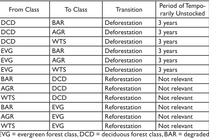
Table 6. Example LULC and forest strata transition table showing all possible transitions.
From Class To Class Transition Period of
Tempo-rarily Unstocked
DCD BAR Deforestation 3 years
DCD AGR Deforestation 3 years
DCD WTS Deforestation 3 years
EVG BAR Deforestation 3 years
EVG AGR Deforestation 3 years
EVG WTS Deforestation 3 years
BAR DCD Reforestation Not relevant
AGR DCD Reforestation Not relevant
WTS DCD Reforestation Not relevant
BAR EVG Reforestation Not relevant
AGR EVG Reforestation Not relevant
WTS EVG Reforestation Not relevant
EVG = evergreen forest class, DCD = deciduous forest class, BAR = degraded woodland, AGR = cropland, WTS = wetland
1.8.3.2 Review Existing Data of Biomass Stock Densities and Biomass Net Annual Increments
For the purpose of sampling design and quality assurance of the measured values, all existing data on biomass stock densities must be reviewed. Sources that must be consulted include (lower-ranking options may only be used if higher-ranking options are not available): (a) peer-reviewed scientific literature conducted within the reference region, (b) peer-reviewed scientific literature from an area similar to the reference region, (c) non peer-reviewed reports or studies from the reference region or similar areas. Sources that contain a measure of the variation of the values (range, standard deviations, standard errors, or coefficients of variation) are specifically useful, since these can be used for preliminary determination of the number of sampling plots required during field sampling. For every data source used, note the following items: 1. Methodology (field inventory, extrapolation from satellite imagery,
ecosystem model, or GIS analysis). 2. Number of measurement plots used.
3. Whether all species are included in the sampling.
4. The minimum DBH of measured trees in the biomass inventory. 5. Region in which the samples were taken.
2. Review existing data on net annual increments of biomass