13
The Biodeversity of Mangrove in Ngantep Coastal, Malang District
Rona Aji Lestyaningrum
1, Mohammad Mahmudi
2, Nuddin Harahab
31 Department of Program Resource Management Environment and Development, Brawijaya University 2 Department of Water Resource Management, Faculty of Fishery and Marine Sciences, Brawijaya University
3Department of Fisheries Socio-Economic, Faculty of Fishery and Marine Sciences,Brawijaya University
Abstract
The purpose of this research are (1) identify and analyze to mangrove vegetation on the NgantepCoastal; (2) Identify associated biota in mangrove vegetation on the CoastalNgantep. The research was conducted in the CoastalNgantep area of Malang District on april 2016. The method of measurement mangrove by using the method the combination and line transect plot with line plot 10 x 10 m2square, in each line there are subplot with 5x5 m2 and 2x2 m2square. The categories
of sample will be discribed were trees, sapling and seedling. The result of this researh found that the composition and the vegetation level of mangrove forest divided into Importance Value Index (IVI) Sonneratia alba (tree) 128.63%, (sapling) 62.19%; Excoecaria agallocha (sapling) 63.72%; Xylocarpus granatum (sapling) 29.45%; Rhizophora mucronata (seedling) 116.21% and Nypa fruticans (seedling) 83.79%. The number of IVI discribe that Sonneratia alba hight influence for the stability of ecosystem in mangrove forest in suite research. There were five families that make up the mangrove vegetation: Lythraceae, Rhizophoraceae, Euphorbiaceae, Meliaceae and Arecaceae.Mangrove vegetationon the Ngantep Coastaldominated by the mangrove species of Sonneratia alba, with the low ecosystem show not yet stable. Fauna in mangrove vegetation NgantepCoastalbecome form between two groups of terrestrial and aquatic.
Keywords: associated biota, biodiversity, composition, mangrove, structure
INTRODUCTION
Mangrove ecosystem can be found in the muddy as in mud tidal, estuaria and the mintakatlitoral. In indonesia mangrove can grow in various a substrate the mud, sand , corals and sometimes of stone.But mangrove can grow fertile in a substrate yan muddy sheltered there from tide and obtain input river[1]. Mangrove forests in java, in 1985 is 170.500 ha, decline in 1997 broad mangrove of 19.077ha (11,19 %)[2]. The highest number of shringkage of its in East Java is 7.700 ha [3]. Those varieties is classified into some family: Rhizophoraceae,Aviciniaceae, andSonneratiaceae. Others types are Xylocarpusgranatum, X.
moluccensis,Lumnitzera sp., Phempisacidula, andExoecariaagallocha[4].
Mangrove ecosystem is the most productive community which is producing biomass from the leaves (±90%), then will be saved in the sediment (±10%), or taken along to the other ecosystem (±30%) [5]. This biomassa feed the detritus organism which is liing in the mangrove ecosystem and the coastalalaround it. Whereas the ecology function of Mangrove are carbon sekuestration, filtering thepollution material, stabilizing the coastal from the erosion, instrusion the sea water,
Address correspondence writer: Rona Aji Lestyaningrum Email : [email protected]
Alamat : Program Pascasarjana, Universitas Brawijaya Jl. MT Haryono 169, Malang 65145
and forming a new land, keeping naturalness habitats, becoming a living destination, hatchery, nursery ground and growing up all varieties of fishes, shrimps, shells, birds, and others animals. It also has a social function as a conservation area, education destination, ecotourism place and cultural identity. [6][7][8].
The decreasing existances of Mangrove in every year because of the growing population of human, forrest logging and fishpond. These are the main threat of mangrove forest preservation in Java[9]. While, the damaged mangrove can be caused by reclamation and over sedimentation, pollution, and mining. Based on the data of 2007, the existance of mangrove forest in East Java Province particularly Malang Districtwas 340 ha which is located in some kecamatan such as Ampelgading, Tirtoyudo, Sumbermanjing Wetan, Gedangan, Bantur dan Donomulyo. The damaged of Mangrove in kecamatan Gedangan was 181,5 Ha [10] . However the newest data of 2015, the area of mangrove forest was narrower 64,7 Ha in a good condition.[11] .
14
about biodiversity in Ngantep coastal. Based on the description above , a research needs to be conducted (1) identifying and analizing mangrgove vegetation in Ngantep Coastal: (2) identifying the association of biota.
METHOD
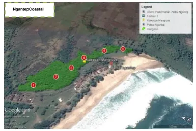
Research is conducted in Ngantep coastal, MalangDistrict(Picture 1) on April 2016. The reason of determine the location because the high number of its mangrove biodiversity, so the qualitu of its management can be increased. The materials used in this research are : mangrove and biota as a object observed. Meanwhile, the research tools are : stationery, digital camera, measuring tape, and raffia.
The research method is analytic descriptive using quantitative approach. Tha datum consist of primary data and secondary data.
a. Primary Data
Primary data of this research are : (1) mangrove vegetation (density, frequencies and vegetation cover) ; (2) the assosiation of Biota b. Secondary Data
The secondary data is obtained from the related government institutions : (1) Department of fisheries and maritime affairs of MalangDistrict; and (2) The government forestry of KPH Malang.
Collectiong Data
The data collection method was done through direct observation in the field, measuring the potential of mangrove forest. Unit sample used in the analysis of activities in the mangrove forest vegetation is transect / path deliberately chosen (purpusive sampling). Line width used was 10 meters in the direction perpendicular to the direction of the mainland coastalline. For mangrove forests growing on the riverbank path direction perpendicular to the line of the river. If both are used it is necessary to arrange in order to track the direction perpendicular to the coastal not to intersect with the path direction perpendicular to the river [12].
intersect with the path direction perpendicular to the river.The transect tract was made perpendicular using shoreline 10 x 10 m2. That
transect is consist of 6 plots , its wide adjusts to plant stratification. Furthermore transect was divided into plots measuring 10x10 m2 (tree), 5x5
m2 (saplings), and 2x2 m2 (seedlings).Every
founded mangrove species was identified, measured the stem on the 1,30 cm as high as the human chest, then each of its species will be identified in detail.
Data Analysis
Vegetation data analysis was performed to determine the values of the parametersmeasured, such as the dominance of the vegetation on the other vegetation throughImportant Value Index (IVI / INP = Indeks Nilai Penting) with formula is : [13]:
Density (K) = Amount of species individu
Total plot area
Relative
Density (KR %) = Density of current species
Density of all species 𝑥 100%
Frequency (F) = The number of kind plots occupied
Number of whole plots
Relative
Frequency (FR %) = Frequency of a kind of species
Frequency of all species 𝑥 100%
Vegetation cover (C) = ∑(πDBH2)
4 /A
DBH =CBHπ Description :
DBH = diameter of tree types-i (cm) π = Konstanta (3,14)
A = Total area of the area sample (for instance total area of tenement sample)
CBH = A circle of tree as tall as the chest
RelativeVegetation cover (FR %) =
Broad the closure of a kind of species
Total area for all species 𝑥 100%
All relative value of the three the calculation dijumlah to get Important Value Index (IVI) : Relative Density of speciesa(KR) + Relative
Frequency of speciesa(FR) + Relative Vegetation
Cover of speciesa(CR). IVI used to determine
domination its kind.To know the diversity of mangrove species used formula diversity Index of Shannon-Wiener [14]:
H′ = − ∑ (niN) log(niN)
S
i=1
Description :
H’ = Diversity Index of Shannon-Wiener ni = Amount of species individu to-i N = Amount of individu total
15 community. Range Shannon-Wiener index values
are classified as follows :
H’<1 = Small population diversity and ecological pressures are very strong
1<H’<3 = Middle diversity
H’>3 = High diversityand occur ecosystems balance
Picture 1. Map of Ngantep Coastal , Malang District Sign of is marking for sample plot
RESULTS AND DISCUSSION
Mangrove forest in NgantepCoastal is a mixture forest between species, mangrove which growing naturally and the rehabilitation species of Department of Marine and Fisheries (DKP). In 2015, DKP planted 14.100 Rhizopora mucronata
seeds in coastalal area of Desa Tumpakrejo. The temporary wide data of four area in MalangDistrict (Table 1) presents in the table below :
Table1. Mangrove forest wide in the south coastal of MalangDistrict
No Sub-district/ village Wide Condition 1.
Source : Dinas Kelautan dan Perikanan, 2015.
Mangrove Vegetation Structure
There are five type of Mangrove which growing in NgantepCoastal, they live spreadly in the six plot (Table 1). Five species belongs to five famili, those are Lythraceae, Rhizophoraceae, Euphorbiaceae,
Meliaceae and Arecaceae. This findings is substanstial in the term of the limited wide of mangrove forest.
Table 2. The composition of Mangrove species in Ngantep Coastal
No Species identified Local name
3 Excoecaria agallocha
L
Source : The Research Findings, 2016
Based on the result findings (Table 2) S. alba
species was found on the tree phase and seedlings. The result of the relative density S. alba
are 100 trees/ha for tree phase, 41 trees/ha for seeds. The amount which spreading in the particular wide presents density score from its species of mangrove. Density score shows adaptation pattern of particular species with its environment. Species with high score of density score have a high pattern adaptation[15].
In Java-bali, Mangrove forest grow only in the northen coastals of Java and liitle island in Bali, even in East Java it is only 7.750 ha or only 500 ha [16]. The more ironically [17], each year mangrove forest in Indonesia is narrower 43%. The species is founded for high number in Ngantep Coastal is species S. alba. We need to know that this species have a special feature, that is the fruit which can be cooked to be food or even beverages. Because the fruits of its species is consist of starch, also it is one of the carbohydrate sources.
16
Table3. Type Composition, Relative Density (KR), Relative Frequency(FR), Relative Vegetation Cover (CR), IVI dan Diversity Index
(H’) mangrove in Ngantep Coastal.
No Composition KR FR CR IVI H’
Tree :
1 Sonneratia alba Sm 100 100 100 300 0
TOTAL 100 100 100 300 0
Saplings :
1 Sonneratia alba Sm 41.44 36.16 42.49 120.09 0.14
2 Excoecaria agallocha L 41.93 40.39 40.71 123.03 0.16
3 Xylocarpus granatum Koenig 16.63 23.45 16.80 56.88 0.06
TOTAL 100 100 100 300 0.36
Seedlings
1 Rhizophora mucronata Lamk 59.54 56.67 - 116.21 0.13
2 Nypa fruticans Wurmb 40.46 43.33 - 83.79 0.16
TOTAL 100 100 - 200 0.29
Source : The Research Findings, 2016
A minimum amount of mangrove species can be caused of the antropogenic which modify the mangrove habitat for other bussiness , such as land clearing for earthen dam and the human settlement [18]. Moreover, the lower amount of its varieties indicate the ecosystem become stress or the decreasing of the environment. It might be caused mangrove live in extreme area, such as the high level of salinity and muddied substrate, so it needs to survive through the tight selection and the high level of adaptation, the human activity also become one of the factor [19] . The high level of exploitation, unsuitable habitat, and interaction between the species which cause the low amount of mongrove in a place. The result of cover varieties and sapling S. alba species is 100% (trees) and 42.49% (sapling). Meanwhile, E. agallocha (40.71%), X. granatum (16.79%). Cover varieties result can be counted in tree phase and sapling from its trees diameter.
Value Index (IVI) of level tree phase is S. alba
species (300%). Meanwhile IVI level is E. agallocha
(123.03%) and IVI of seedling level nilai penting tertinggi is 116.21% from R. mucronata species. The range IVI of mangrove is 0-300. It means that the higher score of IVI (close to 300), the influence of mangrove in a community is better. A mangrove which has high score of IVI can contribute to the other mangrove variety. Such as : (a) mangrove will have the bigger size; (b) the mangrove growth will be better ; (c) the amount of organic which come from high mangrove manure; and (d) illustrate a good condition of mangrove comprises vegetation density, frequencies and vegetation cover.
It is influenced by the adaptation ability S. alba
species . It has a good adaptation ability because it has pneumatophore from substrate and puddle for taking oxygen from the air. Thus, it can live in an extreem environment, such as : living in a low until high salinity [2], living in a mixed mudded and sand land, for some cases it also lives in rocks and coral.
In general, S. alba species is found in every plot. The physically condition like salinity, ebb and flows of the sea and the type of substrate might have differences and similiarity of the vegetation variation its community. The same species in the different plot might grow because the seed from its species flow with the river current from the sea. Its flow also influence the living ability from some mangrove species which bring nutrient and become substrate. R. mucronata and N. fruticans
distribution is also abundant. It can be found in the first until final plot. It can be caused water salinity around mangrove is (toleransi) salinity which espous dissemination of seed and the type of substrate. [20].
Mangrove is a plant variety that grow in the ebb and flow area. As a machanism of its physiology adaptation to the salinity changing, mangrove have particular ability to overcome the overbalance of salinity. However, the change of salinity can make zoning bring structure for plants mangrove if salinity around that of the substrate place mangrove trees had grown up not in accordance with abilities or tolerance where the mangrove can live.In sum up, vegetation structure define into three components [20], as follows :
1. Stratification as a profile diagram which present tree stratum, sapling and seeding is the component of its vegetation.
2. Horizontal dissemination from vegetation variation components which illustrate the site and position from a member to the other member are random, aggregated and reguler. 3. The abbundance of mangrove which arrange
those vegetation.
17 mangrove is slower than the others. In general,
mangrove varieties in Ngantep Coastal is low, tree level (0), sapling level(0.36) and dissemination level (0.29). It indicates the existance and distribution of each individual varieties is limited. The lower index score of its varieties is also influenced anthropogenic factor. Beside that, the wideness of the three coastals are limited. Yet, the existance of that mangrove is quite potential for “nursery or hatching area” especially for the shore larks. tourism. The type of biota is founded in mangrove area of Ngantep Coastal are biota above the trees and water biota. The function of mangrove ecosystem is a habitat of some various biota. Some of them are sticking biota on the tree, immersing themselves and crawl in the base water [23].
Mangrove ecosystem animals group in Ngantep Coastal become a mixed group, those are teresterial animal and aquatic animal. Teresterial group in mangrove ecosystem of Ngantep coastal are Egretta garzetta, Varanus salvato and
Mabouia multifasciata. While the aquatic animal are Gelodok fish (Periopthalmodon schlosseri) and Blanak fish (Mugil chepalus); mollusca group like
Melanoides tuberculate, Cerithidea quadrata, Telecopium telescopium, Cerithidea quoyii. The existance of these fauna can be an alternative development potential of other mangrove tourism destination. For example the birds variation, fishing and photography.
CONCLUSION
There are five species of mangroves which grow in Ngantep Coastal. Those are belonging to fives family: Lythraceae, Rhizophoraceae, Euphorbiaceae, Meliaceae and Arecaceae. The trees are more dominant as a living creature in this forest, especially Sonneratia alba, while the low ecotourism. Mangrove animal ecosystem community in Ngantep Coastal mix from two groups : terestrial animal and aquatic animal.
ACKNOWLEDGMENT
The writer thanks to Mr. Dr. Ir. Mohammad Mahmudi, MS and Dr. Ir. Nuddin Harahab, MP , as a assessor team which assess the writer from the beginning until the final of the research.
REFERENCES
[1]. Setyawan, A. D., K. Winarno, dan P. C.Purnama, 2003. Review: Ekosistem mangrove di Jawa: 1. Kondisi Terkini. Biodiversitas. 4 (2). Hal.133-145. [2]. Septian, W. 2002. Kajian Ekonomi Ekosistem
Hutan Mangrove Mengejutkan. Republika. 28 Januari 2015
[3]. Chong, E. T., R.S. WirakusumadanS.S. Achmadi. 1990.Mangrove Forest Resources in Indonesia. Forest Ecology and Management. 33/34: 45-57.
[4]. Hari, S. 2009. Biodiversitas Mangrove Di Cagar AlamPulau Sempu. Jurnal Sainstek, 8(1), Juni 2009. Universitas Jember.
[5]. Duarte, C.M. and J. Cebrián. 1996. The Fate Of Marine Autotrophic Production. Limnology and Oceanography. 41:1758-1766
[6]. Manassrisuksi, K., M. Weir, and Y.A. Hussin. 2001. Assesment of Mangrove Rehabilitation Programme Using Remote Sensing and GIS: A Case Study of Amphur Khlung, Chantaburi Province, Eastern Thailand. 22nd Asian Conference on Remote Sensisng.Singapore 5-9 November 2001.
[7]. Ng, P.K.L. and N. Sivasothi. 2001. A Guide to Mangroves of Singapore. Vol.1: The Ecosystem and Plant Diversity andVol. 2: Animal Diversity. Singapore: The Singapore ScienceCentre.
[8]. Ong, J.E. 2002. The Hidden Costs of Mangrove Services: Use of Mangroves for Shrimp Aquaculture. International Science Round Table for the Media, Bali Indonesia, 4 June 2002. Jointevent of ICSU, IGBP, IHDP, WCRP, DIVERSITAS and START.
[9]. Hasmonel, M.W. Purwaningdyah, dan R. Nurhayati. 2000. Reklamasi Pantai dalam Hubungannya dengan Pendaftaran Tanah (Studi Kasus di Pantai Utara Jakarta).
Jakarta:Universitas Terbuka.
[10].Dinas Kelautan dan Perikanan. 2007. Inventarisasi Kawasan Mangrove di Kabupaten Malang. Laporan Akhir.
[11].Dinas Kelautan dan Perikanan. 2015. Penyusunan Rencana Zonasi Kawasan Konservasi Wilayah Pesisir Kabupaten Malang. Laporan Pendahuluan
18
[13].Bengen, D.G. 2002. Ekosistem dan Sumberdaya Alam Pesisir. Sinopsis. Pusat Kajian Sumberdaya Pesisir dan Lautan. Fakultas Perikanan dan Kelautan. IPB.Bogor. [14].Kent, Martin dan Paddy Coker. 1992.
Vegetation description and analysis: A practical approach. London:Belhaven Press. [15].Fachrul, M.F.2007. Metode Sampling Bioekologi. (Cetakan pertama). Jakarta: Sinar Grafika Offset.
[16].BAPPENAS. 2003. Indonesian biodiversity Strategy and Action Plan Dokumen Regional. Jakarta: Badan Perencanaan Pembangunan Nasional.
[17].World Bank. 2001. Indonesia: Environment and Natural Resource Management in a Time of Transition. Jakarta: The World Bank. [18].Saru, A., A. Tuwo, W. Samad. 2009. Model
Mitigasi Bencana Akibat Pengaruh Sedimentasi Pantai Kabupaten Biringkassi Pangkep. J. Sains & Teknologi. Agustus 2009. 9(2) : 106 – 114. ISSN 1411 – 4674.
[19].Tapilatu, Y. dan D.Pelasula 2012. Biota Penempel yang Berasosiasi dengan Mangrove di Teluk Ambon bagian Dalam. Jurnal Ilmu dan Teknologi Kelautan Tropis,4(2): 267-279. [20].Kepel, R. Ch., L. J. L. Lumingas, dan Hendrik B.