MAPPING THE WORLD - A NEW APPROACH FOR VOLUNTEERED
GEOGRAPHIC INFORMATION IN THE CLOUD
M. S. Moeller a, b *, S. Furhmann c
a
University of Bamberg, Germany - [email protected] b
Beuth University of Applied Sciences, Berlin, Germany c
Geography and Geoinformation Science, George Mason University, Fairfax, Virginia, USA - [email protected]
Commission VI, 1-3
KEY WORDS: OSM, Volunteered Geographic Information, Ebola, American Red Cross, Humanitarian Openstreetmap Team
ABSTRACT:
The OSM project provides a geodata basis for the entire world under the CC-SA licence agreement. But some parts of the world are mapped more densely compared to other regions. However, many less developed countries show a lack of valid geo-information. Africa for example is a sparsely mapped continent. During a huge Ebola outbreak in 2014 the lack of data became apparent. Help organization like the American Red Cross and the Humanitarian Openstreetmap Team organized mappings campaign to fill the gaps with valid OSM geodata. This paper gives a short introduction into this mapping activity.
* Corresponding author
1. INTRODUCTION
Volunteered Geographic Information (VGI) and Cloud computing are terms with a strong link one to each other. The direct and obvious link between VGI and Cloud Mapping is the OpenStreetMap (OSM) project. OSM has been launched in 2004 by Steve Coast and since then the idea of a map covering the entire world has developed to huge mapping project. Everybody is invited to participate at OSM, and the project depends only on the voluntarily given geo-information of engaged mappers. OSM has become the most popular VGI mapping project with a number of ca. 2.100.000 mappers (in May 2015); the Ushahidi project is an alternative free world map that has become available too.
2. OSM: ADVANTAGE AND CHALLENGES
The big advantage of the OSM project is the fact, that geodata can be used for free under the creative common by share alike license agreement. For centuries almost every map and the geodata used for these maps where protected by strong copyright laws. Violation of these copyrights lead to conviction and compensation of the mapper. Official geodata might be ordered from one of the big providers (official mapping agencies and commercial geodata enterprises). But those data is comparatively expansive.
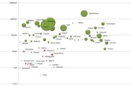
The correctness (geospatial and attributes) of the OSM data is from a high quality level (Hackley 2008). This fact is true especially for densely populated regions in the industrialized, wealthy parts of our planet. However, some regions are strongly underrepresented in the OSM database. Predominantly less developed countries lack a of validated and dense OSM geo-database. We can state that poor countries with bad life conditions (hunger, health, short life expectance) show a huge absent in the OSM database. The relation between country size and OSM data size is shown in fig. 1.
Figure 1. OSM data size for African & European countries. Bubble size equals data size (Moeller & Fuhrmann, 2015).
3. IMPROVING OSM DATA "ON DEMAND"
Many of the poor and less mapped countries are located in Africa and some countries in Africa are affected by huge catastrophes in recent times. The Ebola outbreak in 2014 for example occurred in many countries in Western Africa. Organizing help for the people and fighting against the spreading of the Ebola disease needed a valid map for precise spatial planning efforts. It turned out that OSM data is the most dense geodatabase available for these countries. Official geodata, both from administrative surveying organizations and commercial map providers have not been available in a quality and density needed for fighting against the spread of the disease.
Consequently big help organizations like the American Red Cross in cooperation with the initiative HOT (Humanitarian Openstreetmap Team) started the initiative to map the missing parts of Africa in a comparatively short time period. Therefore
The International Archives of the Photogrammetry, Remote Sensing and Spatial Information Sciences, XL-6/W1, 2015 ISPRS Workshop of Commission VI 1-3, Advances in Web-based Education Services, 18–19 June 2015, Berlin, Germany
This contribution has been peer-reviewed.
many so called "mapathons" (map marathons) have been initiated and held by these organization. Mapathons bring interested, voluntarily working mappers from wealthy, developed parts of the world together at on big mapping event. The American Red Cross for example organized a series of Mapathons in Washington D.C. during fall 2014.
The goal of the events is the detailed digitizing of previously defined mapping regions. These are at the end small tiles, each is about 1 x 1 km² in size. At these Mapathons a short and general introduction into the OSM project and the work with OSM frontends (e.g. Potlatch, JOSM) has been given by HOT at the start. The volunteering mappers were then prepared and started adding identifiable objects from a visual aerial or satellite image directly into the OSM database.
Most important objects to map are buildings, all kind of streets and drivable path, waterways and the obvious landuse (e.g. agricultural usage, trees, forest, open green space, etc.). Some of these objects can be identified easily from the human interpreter. However, the final and correct attribution (e.g. building usage = school), has to been done and verified by mappers in the field with an appropriate local knowledge.
4. CONCLUSIONS AND OUTLOOK
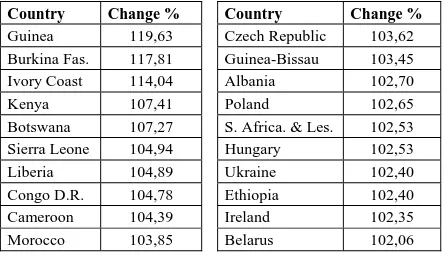
When observing the OSM geodata represented for selected regions in Africa regarding the size, we can observe a huge increase of data volume for the less developed parts of the world in recent times (tab. 1).
Country Change % Country Change %
Guinea 119,63 Czech Republic 103,62 Burkina Fas. 117,81 Guinea-Bissau 103,45
Ivory Coast 114,04 Albania 102,70
Kenya 107,41 Poland 102,65 Botswana 107,27 S. Africa. & Les. 102,53
Sierra Leone 104,94 Hungary 102,53
Liberia 104,89 Ukraine 102,40 Congo D.R. 104,78 Ethiopia 102,40
Cameroon 104,39 Ireland 102,35 Morocco 103,85 Belarus 102,06
Table 1. Change of OSM data size for selected African & European countries, observed between 10 Nov. 2014 - 6 Dec.
2014 (Geofabrik 2015), (Moeller & Fuhrmann , 2015).
This is the result of the strongly increased mapping activity from many volunteered mappers all over the world. The Ebola outbreak could be embanked successfully and some countries (Liberia on May, 9th 2015) claim themselves now free of Ebola (SPIEGEL). However, new challenges appear with new catastrophes somewhere in the world. The Nepal earthquake is the most recent event and again, HOT is very engaged to increase the sparse geo-data basis for the Himalayan region.
ACKNOWLEDGEMENTS
We especially thank the American Red Cross team, Washingtoon D.C. and the HOT members for their engaged work and the support of our research.
REFERENCES
Hackley, M. 2008. How good is Volunteered Geographical Information? A comparative study of OpenStreetMap and Ordnance Survey datasets. http://www.ucl.ac.uk/~ucfamha/ OSM%20data%20analysis%20070808_web.pdf,
(17 May 2015).
Geofabrik 2015. http://download.geofabrik.de/, (17 May 2015).
Humanitarian Openstreetmap Team (HOT), 2015: http://hotosm.org/projects, (17 May 2015).
Moeller, M., Fuhrmann, S. 2015. Cloud Mapping im Krisenmanagement. Kartographische Nachrichten, 1/2015, pp. 7-14.
OpenStreetMap (OSM) 2015: http://www.openstreetmap.org, , (17 May 2015).
SPIEGEL 2015, http://www.spiegel.de/gesundheit/diagnose/
ebola-who-erklaert-epidemie-in-liberia-fuer-beendet-a-1033016.html, (17 May 2015).
Ushahidi 2015: http://www.ushahidi.com/, (17 May 2015).
The International Archives of the Photogrammetry, Remote Sensing and Spatial Information Sciences, XL-6/W1, 2015 ISPRS Workshop of Commission VI 1-3, Advances in Web-based Education Services, 18–19 June 2015, Berlin, Germany
This contribution has been peer-reviewed.