International Journal of Fisheries and Aquatic Research ISSN: 2456-7248
Impact Factor: RJIF 5.44 www.fishjournals.com
Volume 3; Issue 2; April 2018; Page No. 08-12
The density and diversity of mangrove species relation to the sustainability of fisheries resources in
Sidoarjo Regency
M Tajuddin Noor, Ully Wulandari
Fisheries Resources Utilization Studies Program, Faculty of Agriculture, University of Dr. Sutomo Surabaya, Surabaya, Indonesia
Abstract
Sidoarjo is one of the area impacted directly from sedimentation due to overflow of lapindo mud which resulted in the formation of a new island called Pitu Gajahan. The island is mud, so overgrown with mangroves. This research was conducted to find out the density and diversity of mangrove as well as knowing the composition of the different types of catches by fishing on site research. The method used was a survey using a transect quadrants and the interview against the activity of catching fish by local fishermen. The results showed that mangrove diversity index was 0.6154-1.3533 contains the categories of low-medium. The value of the density is 11.5877.8 trees per acre and categories include well-being. The composition of the catch is that the dominant research location is keting (Arius nenga).
Keywords: mangrove, diversity, density, composition type types of catches, Sidoarjo
Introduction
The coastal area in Sidoarjo is one of the coastal areas with a fairly intensive utilization. The activities of fisheries became the dominant activity and is the biggest farming subsector reached more than 40% (BPS Sidoarjo, 2016) [1]. The occurrence of overflow of lapindo mud in sidoarjo at 2006 causing many changes in Sidoarjo coastal. The development of Sidoarjo coastal is one of the phenomena that need to be examined. This phenomenon happens from time to time along the shoreline of Sidoarjo that became the real evidence of the existence of the geomorfik processes like sedimentation process intensive. Studies on the development of the Sidoarjo coast is needs to be done so that the planned construction does not result in a negative impact on the surrounding environment (Widiana et al., 2011) [2]. This is described by Dahuri (2004) [3] that development activities either directly or indirectly will have an impact on coastal waters and beaches so as to reduce the negative impact of too great need for assessment and special management associated with it.
The first step you can take to prevent the occurrence of degradation of areas for fishery both for utilization as well as spawning areas, hence the need for a review to find out the total area of mangrove and diversity as a belt Beach and as the main ecosystems in the sustainability of aquaculture businesses. The purpose of this research is:
1. Get the value of the density of the mangroves on the island of Pitu Gajahan Sidoarjo
2. Get the value of the diversity of mangroves on the island of Pitu Gajahan Sidoarjo
3. Find out the composition of the type of the catch of fishermen on the island of Pitu Gajahan Sidoarjo
4. Predicting the potential expansion of the mangrove areas on the island of Pitu Gajahan Sidoarjo
Materials and methods
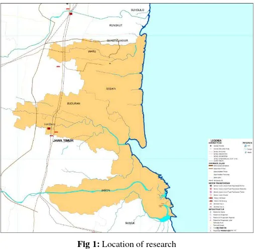
This research was conducted in Pitu Gajahan island at Jabon, Sidoarjo in January 2018 (Figure 1). Research location was chosen because it is one of the locations that have fishery and is assigned as the backup area waters conservation area.
Fig 1: Location of research
speaker set up purposive sampling provide the research. Dahlan (2015) [4] says that the selection of a group of subjects in purposive sampling was based on certain traits that are seen to have relevance of closely with discrete populations that were already known before, in other words the ample unit you call tailored to specific criteria that are applied based on the research objectives. This survey method is a method which is done to get or obtain the facts from the symptoms and find out factually (Nazir, 2003) [5]. Secondary data collection is obtained from the Marine and Fisheries Agency of Sidoarjo Subdistrict Offices and data research results before.
Data Analysis
Mangrove analysis done on the receding waters at the time so as to allow an observer to observe the seedling (for mangroves). Analysis of the density of the mangrove is done by calculating the index of important values (IVI). According to Sofian et al., (2012) [6] in Agustini (2016) [7], for the calculation of the index value of the important mangrove uses the following formula
1. To the extent of the tree using the formula: IVI = RDi + RFi + RCi
2. To the extent and For the stake using the formula: IVI = RDi + RFi
Where
IVI: Index of Important Values Rdi: Relative Density
Rfi: Relative Frequency Rci: The Closing of the Relative
Based on the Shannon diversity index Wienner in Krabs (1998) [8], the value of diversity in the mangrove islands of Pitu Gajahan is as follows:
Where
H' is Shannon Wienner’s diversity index
NI is the number of individuals of the species N is the total number of individuals of all species
Table 1: Parameter assessment of mangrove diversity
Nilai H Kategori
0 ≤ H≤ 1 Low Diversity
1 ≤ H ≤ 3 Medium Diversity
H > 3 High Diversity
The sedimentation area will predictably be analyzed using satellite image data. The analysis is done by looking at changes in the coastline that occurs in the area of research in the last 5 years. Changes in the coastline in any year would be represents the forecasts predictions extents of the island in the future, so that the potential for growth as the region's mangrove and coastal biota spawning will be increasingly high goals. The type of composition was caught are views of the catches by fishermen on site research to conduct a fishing operations at Sidaorjo. The catch is then seen and noted the type of the composition results from the catch, then seen the number of species was caught.
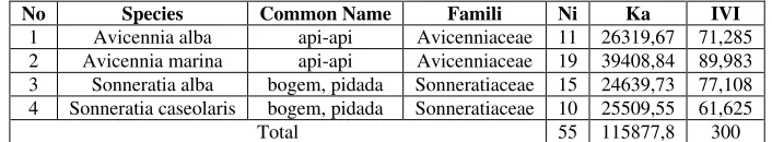
Results Mangrove
In this study, the types of mangroves found is Avicennia alba (api-api), Avicennia marina (api-api), Sonneratia alba (bogem pidada), and Sonneratia caseolaris (bogem pidada). The result analysis of mangrove vegetation located on the island of Pitu Gajahan presented at table 2.
Table 2: The results of the mangroves analysis at Pitu Gajahan Island
No Species Common Name Famili Ni Ka IVI
1 Avicennia alba api-api Avicenniaceae 11 26319,67 71,285 2 Avicennia marina api-api Avicenniaceae 19 39408,84 89,983 3 Sonneratia alba bogem, pidada Sonneratiaceae 15 24639,73 77,108 4 Sonneratia caseolaris bogem, pidada Sonneratiaceae 10 25509,55 61,625
Total 55 115877,8 300
Description
Ni : number of species
Ka : the absolute density (the number of tree species per unit area)
INP : index of important values (ecological depict a species in a community)
Based on the above data it is known that that the value of the density of mangroves on the location of the sampling is taking
115877.8 trees per acre which the density indicates that at these locations included in the density well-being. The density that is the number of individuals in each hectare of land area. The data density of an ecosystem can describe the level of capability or efficiency of a land (Hidayah et al., 2013) [9]. The value of diversity index obtained from the results of the analysis using the formula Shannon Wienner at the station I is as follows:
Table 3: Trees habitus in the station I
Type of Mangrove ni The Index of Diversity (H')
Avicennia alba 11 0,3218
Avicennia marina 19 0,3671
Sonneratia alba 15 0,3543
Sonneratia caseolaris 10 0,3099
Table 4: Stake habitus at the station I
Type of Mangrove Ni The Index Of Diversity (H')
Avicennia sp. 25 0, 2532
Sonneratia sp. 11 0,3622
Total 0, 6154
Table 5: Seedling habitus at the station I
Type of Mangrove Ni The Index of Diversity (H')
Avicennia sp. 8 0,335
Sonneratia sp. 7 0,355
Total 0, 6909
Mangrove diversity index is 0.6154-1.3533 which means that the index of diversity on the Pitu Gajahan are belongs to the low-being diversity. The taking of sampling analysis of mangrove vegetation in Station II done at coordinates 07°34'01.3"S 112°52'37.4”E, which in that location is not
found with mangrove trees, the habitus is just kind of a stake and seedling so that the analysis do only use the index value diversity H'. Following are the results of the calculation of the index of diversity at the point the station II:
Table 6: Stake habitus in Station II
Type of Mangrove Ni The Index of Diversity (H')
Avicennia sp. 16 0,348075
Sonneratia alba 19 0,361511
Sonneratia caseolaris 28 0,360413
Total 1,07
Table 7: Seedling habitus in Station II
Type of Mangrove Ni The Index of Diversity (H')
Avicennia sp. 15 0,1866
Sonneratia sp. 4 0,328
Total 0,1546
Based on the table above, note that the mangrove diversity index at point II is included in the category of low (0.1546)-moderate (1.07).
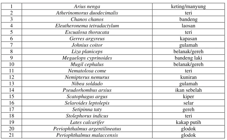
The composition of the type of the catch of fishermen On fishery in Sidoarjo Regency, rely on prawns and milkfish
as the leading commodities were the epitome of Sidoarjo. To capture fisheries in dominance by species keting, snapper, mullet, etc. The following is an inventory of the types of fish found in coastal waters of Sidoarjo:
Table 8: An inventory of the types of marine fish in the waters of Sidoarjo
1 Arius nenga keting/manyung
2 Atherinomorus duodecimalis teri
3 Chanos chanos bandeng
4 Eleutheronema tetradactylum laosan
5 Escualosa thoracata teri
6 Gerres argyreus kapasan
7 Johnius coitor gulamah
8 Liza planiceps belanak/gereh
9 Megaelops cyprinoides bandeng laki
10 Mugil cephalus belanak/gereh
11 Nematolosa come teri
12 Nemipterus nemurus kuniran
13 Nibea soldado gulamah
14 Pseudorhombus arsius ikan sebelah
15 Scatophagus argus kiper
16 Selaroides leptolepis selar
17 Setipinna taty gereh
18 Stolephorus indicus teri
19 Lates calcarifer kakap putih
20 Periophthalmus argentilineatus glodok
22 Carcharhinus leucas Hiu sungai
23 Astrropteryx semipunctatus Ikan gobi
24 Glossogobius biocellatus Gobi estuari
Recorded as many as 24 species of fish identified, is largely a kind of fish that have a high economic value.
Discussion
Sidoarjo is located between the two major rivers namely the Porong River and the river so famous as Surabaya city of Delta. Views of a landscape, in a macro, it consists of farming and coastal areas in the East and permukinan and agricultural areas in Central and Western parts. Administratively, Sidoarjo is politically subdivided into 18 districts, 322 villages and 31 village. As for the coastal area in sidoarjo bejumlah 5 sub-district, sub-district of Waru Subdistrict Sedati, Sidoarjo Buduran Subdistrict, district, Subdistrict and Jabon.
Extensive mangrove forests in Sidoarjo mangrove ecosystem data according to the interpretation of indonesia (LIPI) is estimated at 723.09 Ha. Sidoarjo is one of the central economic and industrial in East Java, this is evidenced by the increasing number of industry and settlement. Some areas of the coast of East Java who had suffered damage to ecosystems due to abrasion of the mangrove coast, among others, in Lamongan, Gresik and Surabaya (Arisandi, 2011) [10]. Meanwhile, Kusumowardhani (2010) [11] reported that in the area of Bangkalan Regency South coast, mangrove ecosystem damage also brought impact abrasion and intrusion of sea water into the wells of the citizens.
The damage of mangrove forest in Sidoarjo Regency more caused by the activities of illegal logging to many utilize and sale mangroves wood from api-api (Avicennia sp).
Hidayah dkk (2013) [9] mention that mangrove forests in Sidoarjo is experiencing a reduction in the total area of 1, 236. 42 (Ha) becomes 1,203.35 (Ha). The districts are experiencing the biggest decline in the vast mangrove forests are Sub Jabon (55.94-Ha). Mangrove land in Sidoarjo has type a coastal plain is a narrow path stretching coast dominated the type Avicennia Rhizopora sp, Sp and Sp Excoecaria (Kusumastuti et al., 2011) [12]. Mutaqin dkk (2009) [13] stating the existence of mangrove forests is very essential in Sidoarjo in East Java because more than 50% of the mangrove forests with good status exists in Sidoarjo.
The coastal area in Sidoarjo is one of the coastal areas with a pretty intensive utilization. The activities of fisheries became the dominant activity and is the biggest farming subsector activities reached more than 40% (BPS Kabupaten Sidoarjo, 2016) [1]. Fisheries activities in Sidoarjo is aquaculture pond with an area of cultivation reaches 15, 531. 4 ha (BPS Sidoarjo, 2016) [1]. Pond aquaculture potential activity is capable of supporting the economy of coastal communities Sidoarjo.
The development of the coastal area and the coast in Sidoarjo Regency is one of the phenomena that need to be examined. This phenomenon happens from time to time along the shoreline of Sidoarjo that became the real evidence of the existence of the geomorfik processes like sedimentation process intensive. Studies on the development of the coast and the beach in Sidoarjo is needs to be done so that the planned construction does not result in a negative impact on
the surrounding environment. This is described by Dahuri dkk. (2004) [3] who said that development activities either directly or indirectly will have an impact on coastal watersand beaches so as to reduce the negative impact of too great need for assessment and management of related special things such. Fisheries activities in the coastal area of sidoarjo are found throughout the country, in the context of macro economy at the level of counties as well as East Java fishingactivity in this area fall into the category of regions with a potential fishery base. Based on the location, management and character, the ecosystem, the area of fisheries in the region planning can be grouped into 3 (three), namely Public Waters (swamps, mangroves, rivers and the sea), outdoor (fresh water) and embankment (brackish water).
Conclusion
This research results, obtained that the value of the density of mangroves on the island Gajahan Pitu is currently with 11. 5877. 8 trees per acre and mangrove diversity is low-medium. The composition of the dominant type of catches is keting vulnerabilities based on physical parameters of beach in Pangkep. Geophysical Studies Program. Universitas Hasanudin, 2014.
3. Dahuri R. Resource management of coastal and Ocean Areas Are Integrated. Jakarta: PT Pradnya Paramita, 2004.
4. Dahlan A. Definition of sampling as well as types of sampling methods and techniques. Eureka Education. [Download 2015-2018 Feb 13]. Available at: http://www. eurekapendidikan.com/2015/09/defenisi-sampling-dan-te knik-sampling.html
5. Nazir. The method of research. Jakarta (ID): Four, p. 63 Salemba, 2003.
6. Sofian A, Harahab N, Marsoedi. The conditions and direct benefits of Mangrove Ecosystems village of Penunggul sub-district of Nguling Regency Pasuruan. El-Hayah. 2012; 2(2):56-63.
7. Agustini NT, Ta'alidin Z, Purnama D. The structure of mangrove community in Kahyapu Village, Enggano Island. Enggano journal, 2016, 1(1).
8. Krebs CJ. Ecological methodology (No. QH541. 15. S72. K74 1999.). New York: Harper & Row, 1989.
9. Guidance Z, Wiyanto DB. Analysis of Temporal changes in the extensive Mangrove Forests In Sidoarjo utilizing satellite imagery Data. Journal Bumi Lestari, 2013, 13(2). 10. Arisandi D. Study of the identification of the extent of the
damage of Mangrove Forests in the Coastal Utaara East Java. Research Report. The Environmental Agency Of The Province Of East Java. Surabaya, 2011.
Mangrove Ecotourism in South Pessiir Bangkalan Regency. Marine Journal. 2010; 4(2):15-29.
12. Kusumastuti W, Hendrarto B, Sutrisnanto D, Evaluation of artificial wetland mangrove vegetation in reducing environtmental pollution (a case study of Kepetingan Village in Sidoarjo Regency). Journal of environmental science. 2011; 9(2):L69-74.