Acknowledgements
This report is one of three marine spatial planning (MSP) case study reports produced by the Coastal Resources Center/Rhode Island Sea Grant College Program (CRC) at the URI Graduate School of Oceanography. It is part of CRC’s broader ongoing research and capacity‐building initiative to strengthen the network of marine spatial planning and coastal management practitioners. The purpose of the case studies is to document and share lessons learned from examples of marine spatial planning in the U.S. in order to build the capacity of MSP and coastal management practitioners. Research was conducted in three locations: Rhode Island,
Washington State and San Francisco. The Rhode Island case focused on implementation of the Rhode Island Ocean Special Area Management Plan; the Washington case focused on the ongoing development of the Washington Coast Marine Spatial Plan; and the San Francisco study became a two‐case analysis of two different Coast Guard‐led waterways management
initiatives. CRC has produced three technical reports summarizing case study research as well as a series of shorter publications highlighting key findings.
All documents were developed with support from the URI Coastal Resources Center’s Marine Spatial Planning Advisory Committee members (Geoff Coughlan, Memorial University; Tracey Dalton, University of Rhode Island Department of Marine Affairs; Grover Fugate, Rhode Island Coastal Resources Management Council; Jennifer Hennessey, Washington Department of Ecology; Edward G. LeBlanc, U.S. Coast Guard Sector Southeastern New England; Betsy
Nicholson, National Oceanic and Atmospheric Administration; and Stephen Olsen, Professor in Residence at the URI Graduate School of Oceanography and Director Emeritus of the URI Coastal Resources Center). In particular, CRC’s project team (Jennifer McCann, Tiffany Smythe, Nicole Andrescavage, Christian Fox, Tom Pavitt and Danielle Turek) would like to recognize the
expertise and thoughtful advice provided by Stephen Olsen on all of these products. For further information, please see ww.crc.uri.edu/initiatives_page/msp/.
The authors wish to thank Washington Sea Grant and the Washington Department of Ecology for their assistance in shaping and developing this case study. The authors also thank case study reviewers Jennifer Hennessey and Geoff Coughlan, as well as David Fluharty, University of Washington, for their time and thoughtful insights. Finally the authors wish to thank the many Washington practitioners and stakeholders who contributed to this case study as interview participants or through their participation and dedication to the Washington Coast marine spatial planning process to date.
This report was funded by the Gordon and Betty Moore Foundation and the Rhode Island Sea Grant College Program.
Table
of
Contents
Acknowledgements ...ii
List of Tables ... iv
List of Figures ... iv
List of Acronyms ... v
I. Introduction ... 1
II. Developing this Case Study ... 3
III. A Brief History of the Place ... 4
IV. Laying the Groundwork for Washington State Marine Spatial Planning ... 9
A. Drivers for Marine Spatial Planning ... 9
B. The Marine Waters Planning and Management Law ... 12
C. MSP and Existing State Laws ... 14
V. Developing the Washington Coast Marine Spatial Plan ... 16
A. Planning Area Boundary ... 16
B. Timeline and Resources ... 18
C. Implementing the Timeline ... 19
D. Developing the Goals and Objectives ... 20
E. Collaboration between Agencies, Tribes, and Stakeholders ... 21
F. Engaging Stakeholders and the Public ... 23
G. Research and Data Analysis in support of MSP ... 25
VI. Potential Plan Outcomes and Implementation ... 25
A. Recommendations for New Uses ... 25
B. The Future: Plan Implementation, Monitoring and Adaptive Management ... 26
VII. The MSP Process to Date: Planning Challenges and Stakeholder Concerns ... 29
A. The Functioning of the WCMAC ... 29
B. Stakeholder Concerns ... 29
C. National priorities at expense of local communities ... 30
D. Bottom‐up planning ... 31
VIII. Conclusion and Lessons Learned ... 31
Lesson #1: Understand Where You’re Starting From ... 32
Lesson #2: Manage Expectations ... 32
Lesson #3: Apply flexibility and adaptably to keep your driver compelling. ... 33
Appendix I. State Agencies Involved and Their MSP Roles ... 37
Appendix II. Goals and Objectives ... 40
Appendix III. Outreach and Engagement Methods ... 44
Appendix IV. Research Projects Supporting Washington Coast MSP ... 48
END NOTES ... 51
List of Tables Table 1. Interview Participants ... 3
Table 2. Research Projects Providing Contextual Information (Source: “Washington Marine Spatial Planning” n.d.) ... 48
Table 3. Research Projects Providing Mapped Data Layers (Source: “Washington Marine Spatial Planning” n.d.) ... 48
List of Figures Figure 1. Map of Washington’s Pacific Coast, Puget Sound and Columbia River Estuary (Source: Washington Dept. of Transportation) ... 2
Figure 2. Existing conservation regions within the Washington Coast MSP study area (Source: Washington DNR) ... 6
Figure 3. Tribal areas and incorporated cities in relation to Washington Coast MSP Study Area (Source: Washington DNR) ... 8
Figure 4. Washington Coast MSP Planning Area Boundary (Source: Washington DNR) .. 17
Figure 5. Washington Coast MSP Timeline (Source: Hennessey, 2014) ... 18
Figure 6. Washington Coast MSP Participants (Source: “Washington Marine Spatial Planning” website, n.d.) ... 19
List of Acronyms
BOEM: Bureau of Ocean Energy Management CZMA: Coastal Zone Management Act
CZMP: Coastal Zone Management Program
DNR: Washington Department of Natural Resources DFW: Washington Department of Fish and Wildlife EPA: Environmental Protection Agency
FERC: Federal Energy Regulatory Commission GLD: Geographic Location Description MRC: Marine Resource Committee MSP: Marine Spatial Planning
NGO: Non‐governmental organization NOP: National Ocean Policy
NOAA: National Oceanic and Atmospheric Administration OCNMS: Olympic Coast National Marine Sanctuary
ORMA: Washington Ocean Resources Management Act RCW: Revised Code of Washington
SMA: Washington Shoreline Management Act SAP: Science Advisory Panel
SEPA: State Environmental Policy Act
SMP: Washington Shoreline Master Program SOC: Washington State Ocean Caucus USACE: U.S. Army Corps of Engineers USCG: U.S. Coast Guard
WCMAC: Washington Coastal Marine Advisory Council
I.
Introduction
The Washington State Pacific coast has a long history of its people making a living from its natural resources. Home to four coastal Treaty Tribes as well as
communities that make a living from fishing, tourism, and logging, the people from this region have traditionally played a leadership role in the management of their coasts and offshore waters in partnership with state and federal government. Using tools, including community‐developed shoreline management plans, national and state marine
conservation areas, and formal agreements between government (including Tribes) and user groups, the people of this region have worked to protect the natural resources upon which they so greatly depend, while managing increased human activities. The most recent coastal management tool brought to this region is marine spatial planning (MSP). This began with the approval of a state law in 2010 that required the creation of regional non‐regulatory marine spatial plans: “The state intends to augment the marine spatial component of existing plans and to improve the coordination among state agencies in the development and implementation of marine management plans.”1 Spearheaded by a state Senator, this law was established with support from local individuals concerned about the impact offshore renewable energy would have on their fishing activity.
The first area for which a marine spatial plan is being completed is the
Washington Pacific coast region (see Figure 1). Through the public scoping process, it was determined that the Washington Coast marine spatial plan would have the goal of ensuring “a resilient and healthy marine ecosystem on Washington’s coast that supports sustainable economic, recreational, and cultural opportunities for coastal communities, visitors, and future generations.”2
Figure Washi
e 1. Map of Wa ington Dept. o
ashington’s Pa of Transportati
cific Coast, Pu ion)
II.
Developing this Case Study
To develop this case study, researchers conducted 15 interviews with individuals representing MSP planning staff, industry experts, and local community leaders to better understand a range of perspectives and expectations for this MSP effort (see Table 1). Interviewees were identified with the guidance of the Washington Department of Ecology and Washington Sea Grant because of their active and dedicated
participation in the Washington Coast MSP process. Through the interviews, case study authors sought to understand each individual’s role in and perspective on the process. Interview questions included: How have participants influenced the plan’s development and what do they expect from implementation? How have participants coordinated with each other and with planning leaders to conduct this work? How has history, both
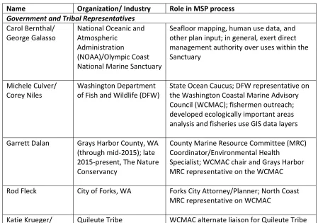
Name Organization/ Industry Role in MSP process
Government and Tribal Representatives
Carol Bernthal/ management authority over uses within the Sanctuary the Washington Coastal Marine Advisory Council (WCMAC); fishermen outreach; developed ecologically important areas analysis and fisheries use GIS data layers
County Marine Resource Committee (MRC) Coordinator/Environmental Health
Specialist; WCMAC chair and Grays Harbor MRC representative on the WCMAC
Rod Fleck City of Forks, WA Forks City Attorney/Planner; North Coast MRC representative on WCMAC
Name Organization/ Industry Role in MSP process Jennifer Hagen
(Krueger); Quileute Tribe marine biologist assisting with MSP scientific/technical issues (Hagen) coordinator; WCMAC staff support; will submit MSP to NOAA for inclusion in coastal Caucus; administers funding allocated for MSP; management of website and online data and tools
Joe Shumacker Quinault Indian Nation Quinault tribal technical staff
Stakeholders
Dale Beasley Columbia River Crab Fishermen’s Association
Commercial fishing representative on WCMAC
Casey Dennehy Surfrider Foundation Recreation representative on WCMAC
Paul Dye The Nature Conservancy Website support and community workshops Arthur (R.D.)
Grunbaum
Friends of Grays Harbor Conservation representative on WCMAC Rich Osborne Researcher Science representative on WCMAC Brian Sheldon Northern Oyster Company
(oyster farm)
Shellfish aquaculture representative on WCMAC; liaison to other aquaculture sectors
University
Penny Dalton Washington Sea Grant State Ocean Caucus; WCMAC member; MSP Science Advisory Panel; MSP outreach; Social and Economic Indicator development
III.
A Brief History of the Place
The Washington Pacific coast and ocean are home to some of the most
the coast. The south coast is characterized by low sandy shorelines and a series of large estuaries. The north coast is less developed than other areas of the state and includes a number of different types of conservation areas including the marine shoreline in the Olympic National Park, National Wildlife Refuges, and the Olympic Coast National Marine Sanctuary. Washington State Parks manages numerous state parks and the Seashore Conservation Area along much of the southern portion of Washington’s coast (see Figure 2). Notably, 15 of Washington’s 39 counties are adjacent to saltwater of some kind, whether the Pacific Ocean, the Columbia River, or Puget Sound.4
Washington is also unique in that its coastal zone includes all lands and waters from the coastline (ordinary low water line for ocean areas, seaward limits of inland water bodies) out to three nautical miles.5 The Washington Pacific coast, comprising four coastal counties (Jefferson, Clallam, Grays Harbor and Pacific), is primarily rural and supported by an economy based on tourism, recreation, and natural resources including commercial fisheries and timber. This region makes up only 2.9 percent of the state’s population according to the 2010 U.S. Census.6 These four counties are currently struggling with higher unemployment and lower incomes than the state average. In November 2013, the state’s average unemployment rate was 5.4 percent while the average for the four coastal counties was over 7.5 percent.7 In 2012, the average per capita income for the four coastal counties was $37,781 compared to the state average of $46,045.8 These counties also have above average retirement age population. In 2014, citizens over age 65 comprised less than 14 percent of the state population, while citizens over age 65 comprised between 18 and 30 percent of the population of each of the four coastal counties.9
Historically, Washington State was economically dependent on its once‐plentiful natural resources, like timber, which have experienced periods of intense extraction. For example, interview participant R.D. Grunbaum, a stakeholder from Grays Harbor,
The Washington coast is also home to four Coastal Treaty Tribes: the Hoh, Makah and Quileute Tribes and the Quinault Indian Nation (see Figure 3). These Tribes are different from other federally‐recognized Tribes because they signed treaties with the federal government that allowed the peaceful settlement of Western Washington in exchange for continued rights to fish, gather shellfish, hunt and exercise other sovereign rights. These treaties, known as the Stevens Treaties, restricted Tribes to very limited reservation areas compared to the territory they originally occupied but reserved the Tribes’ right to fish and hunt in “usual and accustomed areas” outside of the
reservations. These include both terrestrial and marine areas.10 Specifically, after long legal battles, these Coastal Treaty Tribes are recognized with the right to take fifty percent of all naturally occurring shellfish and finfish in tribal “usual and accustomed areas” in accordance with tribal law and fishery management responsibilities.11 In addition, each Tribe maintains its own fisheries management and enforcement staff, enters into management agreements with other co‐managers, and engages in a wide variety of research, restoration and enhancement activities to improve the scientific basis for resource stewardship.i
Several state government agencies are responsible for administering different management programs for Washington’s marine environment (see Appendix I). Chief among these are the Department of Ecology, the Department of Natural Resources (DNR) and the Department of Fish and Wildlife (DFW). These agencies have multiple different responsibilities. The Department of Ecology houses the state’s federally‐ approved coastal zone management program; the DNR manages leases for submerged lands and performs numerous other functions; and the DFW manages state fish and shellfish resources. As in other states, a host of federal government agencies also have authority over managing various aspects of Washington’s marine environment ranging from federally‐managed fisheries and the National Marine Sanctuaries (the National Oceanic and Atmospheric Administration/NOAA) to offshore energy development (the Bureau of Ocean Energy Management/BOEM and the Federal Energy Regulatory Commission/FERC).
i
Figure Washi
e 3. Tribal area ington DNR)
IV.
Laying the Groundwork for Washington State Marine Spatial
Planning
A. Drivers for Marine Spatial Planning
In 2002, AquaEnergy,ii a renewable energy company, submitted a Declaration of Intent to the FERC, asking whether or not their renewable energy pilot project off the Pacific coast of Washington State would require a license. FERC replied that it would.12 This proposal, involving wave buoys off the Makah reservation, was designed to develop a local source of energy for the Tribe. AquaEnergy received a license from FERC in 2007,13 but surrendered the license in 2009 citing “an unfavorable economic climate and restrictions on capital necessary to continue project development.”14 Thus, this project did not come to fruition.
In 2007, a local investor also started a company called Grays Harbor Ocean Energy and developed a proposal to place a renewable energy facility off the Washington coast in the heart of prime crabbing ground. Interview participants
explained how this created tension among local communities who were worried about the impacts on existing uses and the environment, as well as the absence of a proactive plan to address how and where this new use should occur.
Following these renewable energy proposals and discussions, Washington State Senator Kevin Ranker began championing marine spatial planning as a way to
strategically plan for new uses and protect existing uses. Local stakeholders met with their local representatives and helped outline the key components of the Washington MSP law. Interview participants reported how many of these stakeholders saw marine spatial planning as a way to prevent displacement and protect existing sustainable uses from new uses.
In 2010, due in part to Senator Ranker’s leadership, the Washington State legislature enacted law that acknowledged the challenge: “These multiple uses as well as new emerging uses, such as renewable ocean energy, constitute a management challenge for sustaining resources and coordinating state decision‐making in a proactive, comprehensive and ecosystem‐based manner.”15 Additionally, it promoted the
development of marine spatial plans “to build upon existing statewide Puget Sound, coastal, and Columbia River efforts . . . [and] to augment the marine spatial component
ii
of existing plans and to improve the coordination among state agencies in the
development and implementation of marine management plans.”16 Dale Beasley, a crab fisherman and President of the Columbia River Crab Fishermen’s Association, described this series of events that led to the writing of the MSP law:
“In 2010, we had Senator Ranker from San Juan Island have this vision of what he thought we should do with MSP, and he’s a pragmatist in the legislature; he understood that if he didn’t come to the coast and get the coastal legislators on board, it wasn’t going to happen. So, they had the first coastal MSP meeting in Aberdeen, and our coastal legislators were all there, and there were probably ten of us from the fishing community, no one else was there. And we sat down with those legislators to draft the first piece of MSP, and the reason we did that was because Burt Hamner of Grays Harbor Ocean Energy had just put his vision of what the ocean should look like in twenty to thirty years. And, that was enough ocean energy devices on the coast between Westport and the Columbia River to lower the wave climate by eleven percent. . . . There’d be no room for anything else in the ocean. [It would] be 100 percent ocean energy. And our legislators said absolutely that is not the vision for this state.”
Spatial management tools are not new to the Washington coast and have, in fact, served as an effective tool to respond to conflict. In addition to a number of spatial designations such as special fisheries management areas and essential fish habitats designated under the authority of the federal Magnuson‐Stevens Fishery Conservation and Management Act (16 U.S.C. § 1801 et. seq.), Washington has two other spatial management tools in place that were designed with the specific purpose of avoiding conflict between existing uses. They include the Olympic Coast National Marine Sanctuary and the Crabber‐Towboat Lane Agreement. Both tools have successfully achieved their set goals and balance protection of the natural and living resources with appropriate human use (discussed below).
Previous Washington Coast Spatial Management Tools
Olympic Coast National Marine Sanctuary “Area to be Avoided”
In 1994, the Olympic Coast National Marine Sanctuary worked with the International Maritime Organization to designate an “Area to be Avoided” off of the Olympic Coast in order to reduce the risk of marine casualty and pollution damage from another ship‐ related oil spill. The “Area to be Avoided” guides ships over 400 gross tons traveling in and out of the Strait of Juan de Fuca to stay a safe distance offshore to mitigate the potential impact from spills by increasing the time before the oil reaches sensitive habitat in the Sanctuary. Since 1998, the Sanctuary has been monitoring compliance with the “Area to be Avoided,” and in 2014 reported a 97.8 percent compliance rate.17
Crabber ‐ Towboat Lane Agreement
The conflict between oceangoing tugs and commercial crabbers became a major problem off Washington’s coast in the 1970s. As tugs traveled between ports, they ran over crab pots – causing the tugs to foul their propellers in the fishing gear, thus creating a navigational hazard, and causing crabbers to lose their crab pots and thus suffer economic hardship. In order to address this conflict, the two industries developed a non‐regulatory, informal agreement that provided navigable towboat and barge lanes through crabbing grounds. Washington Sea Grant later got involved to help facilitate these negotiations.18 Crabber Dale Beasley explained:
“We’ve tried to encourage all of these uses because we’ve learned to live together over the years. In our area, we’ve got what’s known as a Crabber [Towboat Lane] Agreement; it’s been in place for 45 years. Where we sit down at the table with our industry partners and they tell us what they need and we tell them what we need and then we say ’ok, you need a place to tow, we need a place to fish, let’s agree on what we can set up so you can tow and we can fish ‘cause tow gear through crab gear doesn’t work.’ We still meet twice a year and talk about how things are going and what we can do to improve them, and if someone’s needs have changed, what we can do to address those new needs. We’ve done this for 45 years, and it’s worked really well. Over the years, we’ve had some difficulties, but we’ve always been able to sit down and work those out without any
government intervention.”
It is estimated that this agreement has saved more than $1 million dollars annually for both industries. Each year, Washington Sea Grant facilitates negotiations between the groups, updates charts and distributes charts to industry members.19 Washington Sea Grant Director Penny Dalton described the Crabber‐Towboat agreement as a successful example of marine spatial planning in Washington state: “If you think about it, it’s kind of classic MSP. And it was very successful, noncontroversial, and very effective at reducing the costs associated with the interactions between the two sectors.”
Around the same time, the concept of marine spatial planning was gaining traction at the federal level. In 2010, President Obama issued Executive Order 13547 which established the National Ocean Policy with nine strategic priorities and called on federal agencies to coordinate to implement these priorities through a new National Ocean Council.20 One of these priorities was the development of regional Coastal and Marine Spatial Plans. The associated guidance documents21 called for these plans to be developed for large marine ecosystems, with the option for some planning efforts to be divided into plans for smaller sub‐regions. The West Coast planning region covers the California Current Large Marine Ecosystem within the U.S. Exclusive Economic Zone, which encompasses offshore areas of Washington, Oregon, and California. In addition, the guidance documents acknowledged the role of state plans to serve as a building block for larger regional planning efforts.22 These federal actions brought with them the hope that federal funding and support would be provided to develop marine spatial plans. Because of this, state leaders saw a state‐led MSP process as a way to favorably position Washington to engage in and influence future broader regional planning efforts.
B. The Marine Waters Planning and Management Law
The law that was spearheaded by Senator Ranker (RCW 43.372), officially named “Marine Waters Planning and Management,” defines marine spatial planning as “a public process of analyzing and allocating the spatial and temporal distribution of human activities in marine areas to achieve ecological, economic, and social objectives. Often this type of planning is done to reduce conflicts among uses, to reduce
environmental impacts, to facilitate compatible uses, to align management decisions, and to meet other objectives determined by the planning process.”23 The law’s stated purposes are to build upon existing efforts by augmenting their marine spatial
components, improve coordination among state agencies in marine management, and establish policies to guide state and local agencies in exercising jurisdiction over proposed uses and activities in marine waters.24
stipulates that all state agencies with marine waters planning and management responsibilities are authorized to include marine spatial data and MSP elements into their existing plans and ongoing planning; establishes a “marine interagency team” to lead this work; and permits the state to conduct marine spatial planning in distinct geographic sub‐regions such as the Pacific Coast.
Two foundational elements of marine spatial planning described in the law include a series of maps and an ecosystem assessment. Specifically, the law calls for:
“A series of maps that, at a minimum, summarize available data on the key ecological aspects of the marine ecosystem, including physical and biological characteristics, as well as areas that are environmentally sensitive or contain unique or sensitive species or biological communities that must be conserved and warrant protective measures; human uses of marine waters, particularly areas with high value for fishing, shellfish aquaculture, recreation, and maritime commerce; appropriate locations with high potential for renewable energy production with minimal potential for conflicts with other existing uses or sensitive environments,”26 and
“An ecosystem assessment that analyzes the health and status of Washington marine waters including key social, economic, and ecological characteristics and incorporates the best available scientific information, including relevant marine data. This assessment should seek to identify key threats to plan goals, analyze risk and management scenarios, and develop key ecosystem indicators. In addition, the plan should incorporate existing adaptive management strategies underway by local, state, or federal entities and provide an adaptive
management element to incorporate new information and consider revisions to the plan based upon research, monitoring, and evaluation.”27
As originally passed, the law was not accompanied by a budget for MSP
development, in part because, within the context of President Obama’s Executive Order establishing the National Ocean Policy, it “anticipated that federal cooperation and support will be available to coastal states that are engaged in marine and coastal resource management and planning.”28 Thus, in March 2012, the Legislature amended the law to revise requirements on expenditures from the state account, including prioritizing work on the Pacific Coast marine spatial plan. The amendment also removed a required two‐year timeframe for completing the plan and clarified that marine spatial planning could proceed in separate geographies on different schedules.
The state law also directs the development of a non‐regulatory marine spatial plan. To achieve this, the law requires the state to use existing state and local
authorities: to guide decision‐making among proposed uses, to develop an
implementation plan29 and to be consistent with existing state laws and programs.30 Finally, Washington’s law does not create new authority for the state and prevents the plan from interfering with already permitted activities or those under development during the planning process.31
Washington’s law requires the Washington Department of Ecology to submit the completed plan to NOAA for approval as part of the state’s Coastal Zone Management Program (CZMP) and to implement the plan using existing state authorities. Therefore, the plan will be implemented, in part, using the existing enforceable policies of the Washington CZMP. Washington’s federally approved CZMP contains enforceable policies from six state laws. Of these, the Shoreline Management Act (SMA) and the Ocean Resources Management Act (ORMA) contain policies focused most closely on the management of ocean resources and associated human uses of those resources.32
When completed, the Washington Coast marine spatial plan will include studies of federal waters, including a substantial amount of environmental, ecological, and human use information. This information will be useful for environmental reviews and other planning and regulatory decisions. The Washington Department of Ecology will be able to use the MSP data and maps to assess coastal effects from a proposed project in federal waters, which will be helpful for conducting federal consistency reviews under Washington’s CZMP.33
C. Marine Spatial Planning and Existing State Laws
Washington’s marine spatial plan relies on and builds upon the SMA and the ORMA. Under the SMA, each city or county government with shorelines creates and locally adopts a Shoreline Master Program (SMP) according to state guidelines. This involves a public process that enables comments from the public, agencies and the Tribes. After the Department of Ecology approves an SMP, local governments implement the program.34 These programs have become the cornerstone of
Local jurisdiction extends landward 200 feet of the ordinary high‐water markiii and seaward to the extent of the boundary of the county or city. The jurisdiction of counties and cities along Washington’s Pacific Coast extends offshore three nautical miles. Cities with coastal shoreline each prepare their own SMP, which covers the full extent of their shoreline jurisdiction. The cities do not defer to county plans. However, cities and counties can work together, if they choose.36 Interview participants explained that there is significant buy‐in at the local level for these plans.
The ORMA outlines a set of policies which are administered by the state’s coastal programs and enforceable under the federal Coastal Zone Management Act (CZMA). These include a series of policies and guidelines for state and local management of Washington’s coastal waters, out to three nautical miles. ORMA requires that ocean uses meet a number of broad policies and also receive state approval. These policies are required to be incorporated in local SMPs through the Ocean Management Guidelines (WAC 173‐26‐360). However, ORMA does not have a clear, consistent mechanism for implementation across all state and local agencies. ORMA policies include avoiding and minimizing significant adverse impacts on the environment, economy, and society.37
Coastal planners anticipate that the marine spatial plan will be able to assist implementation of ORMA’s policies by identifying and analyzing important resources and uses upfront, including spatial recommendations for these areas. This, in turn, will provide the information needed for Washington to evaluate, through its federal consistency authority, whether a federal action may have reasonably foreseeable effects on the state’s coastal uses or resources. In addition, the marine spatial plan will provide a common framework for integrating ORMA policies and for providing
information for other state and local agencies to use in their decision‐making.38
Regarding the SMA, the SMPs and the marine spatial plan for Washington’s Pacific Coast share many common traits and are compatible planning processes that can be mutually beneficial. When completed, the marine spatial plan can provide
information and analysis on ocean resources and uses and policy recommendations for local SMP comprehensive updates or future local program amendments. SMPs can be a
iii
“Ordinary high water mark” on all lakes, streams, and tidal water is “that mark that will be found by examining the common and usual, and so long continued in all ordinary years, as to mark upon the soil a character distinct from that of the abutting upland, in respect to vegetation as that condition exists on June 1, 1971.” Source: Revised Code of Washington 90.58.030(2)(b), available online at
http://www.ecy.wa.gov/programs/sea/sma/st_guide/jurisdiction/OHWM.html
source of information for and provide a detailed implementation mechanism for the marine spatial plan in state waters through local shoreline permitting.39
The data and information products from the initial stages of developing the marine spatial plan can contribute to the ocean component of a local coastal shoreline inventory, analysis, and characterization. Once the draft marine spatial plan is
completed, the resulting informational maps, recommended environment designations, and policies can be assessed and further refined by a local jurisdiction for the SMP’s policies and regulations, and for use in the cumulative impacts analysis. Further, local SMPs on Washington’s Pacific Coast are required to address the Ocean Management Guidelines pursuant to ORMA. These guidelines are state regulations that provide specific guidance on how to address ocean uses within a local SMP. Since the MSP law requires the integration and use of existing authorities, the Ocean Management Guidelines policies will also be incorporated into the information, analysis and recommendations in the final marine spatial plan.40
V.
Developing the Washington Coast Marine Spatial Plan
A. Planning Area Boundary
The boundary for the Washington Pacific Coast sub‐region, which is the first MSP area for Washington, includes state waters out to three nautical miles and federal waters out to a depth of 700 fathoms (4200 feet) (See Figure 4). This boundary was selected based on agency, stakeholder, and public input, as explained in the summary report produced for the workshop based on this topic.41 The boundary follows the continental shelf off the coast and ranges from 40 to 60 nautical miles offshore, and extends from Cape Disappointment at the mouth of the Columbia River North to Cape Flattery and includes the estuaries of Willapa Bay and Grays Harbor. The study area covers 7,700 square nautical miles of marine waters. The study area does not include the Strait of Juan de Fuca, the Lower Columbia River Estuary, or Puget Sound.
Figure
e 4. Washingtoon Coast MSP PPlanning Area
Governor’s office with some new members, including voting seats for each of the state agencies that had not been on the original council.
In 2013, during Stage 2, “Understanding Impacts” (see Figure 5), the language of the goals and objectives and the boundary of the MSP were finalized through a scoping process. The Sector Analyses, which identified the current state and future projections for each sector, were conducted for the shipping, fishing, aquaculture, recreation and tourism and renewable energy sectors and concluded in 2014.44 The Ecosystem Assessment continued over the 2013‐2015 biennium with the development of
ecological, social and economic indicators. New datasets such as recreational data and a cohesive data set that identifies ecologically important areas off the Washington coast also were developed. Ecological modeling produced information on predicted at‐sea distribution for seabirds and marine mammals. Additional work was done to bring existing data from seafloor mapping together into a seafloor atlas and to document all existing economic information for the four coastal counties. At the time of this writing, the Washington Coast MSP process is finishing up the ”Understanding Impacts” stage and is in the middle of conducting the use analysis to summarize data on current uses, assess the potential spatial interactions between existing uses and potential new uses, and inform the development of spatial recommendations (Hennessey pers. comm. December 22, 2015).
D. Developing the Goals and Objectives
One of the Department of Ecology’s earliest plan development activities was to work with stakeholders and partners to develop planning goals and objectives. In 2013, with funding and guidance from the state agencies, The Nature Conservancy and
Surfrider Foundation hosted local, community‐based workshops with each of the coastal MRCs. These local workshops helped prepare the MRC members and local industry representatives for the state‐led, goal‐setting workshops where they would represent their county or industry interests. These workshops resulted in a workshop report,
Coastal Voices, which synthesizes stakeholders’ ideas and concerns regarding the
marine spatial plan.45 Following these workshops and later that same year, local government, state and federal agencies, Tribes, and the WCMAC came together for a series of three separate day‐long workshops to develop the goals and objectives of the Washington Coast marine spatial plan (see Appendix II). These workshops built upon the earlier local MRC workshops, with the goal of incorporating stakeholders’ ideas and concerns into the goals and objectives.
Study interview participants explained how, during both the community‐level workshops hosted by Surfrider and The Nature Conservancy, and the larger workshops with local, state, federal and tribal governments, industry representatives and MRC members, many local participants repeatedly brought up one phrase which they felt represented their goals for their own coastal communities: “Protect and preserve existing sustainable uses.” Some commented that this language, which echoed
considerations included in the 2010 MSP law, became the mantra of industry and MRC members on the coast. After extensive dialogue between local stakeholders and state agencies, these exact words were integrated into both Goal 1 and Objective 1 of the official Washington Coast MSP goals and objectives.46 Subsequently, the SOC, WCMAC, and MRCs worked together to draft and recommend a list of actions to help refine the goals and objectives.47
E. Collaboration between Agencies, Tribes, and Stakeholders
Marine spatial planning is designed to integrate decision‐making. Therefore, the planning process requires collaboration with many different groups, including
stakeholder representatives, state agencies, tribes, and federal agencies. For
Washington Coast’s MSP effort, to date, the WCMAC has served as a primary forum for discussions between state agencies and diverse stakeholder representatives. The WCMAC provides an opportunity for stakeholder representatives to provide advice to the state agencies on ocean policy and provides an opportunity for discussions between various stakeholder representatives. In the MSP process, WCMAC meetings provide a space for discussion, clarification and voicing concerns from both state agencies and stakeholder representatives.48 A sub‐group of the WCMAC, referred to as the Steering Committee, has monthly calls with the DNR and Department of Ecology representatives to develop the WCMAC agenda and deal with operational issues.
Another subgroup, the Technical Committee, discusses more detailed issues related to MSP projects and develops draft recommendations for WCMAC consideration at subsequent WCMAC meetings. All WCMAC members are invited to participate on the Technical Committee calls. However, the WCMAC group’s two co‐leads and a group of five or six members routinely participate. Interview participant Joe Schumacker of the Quinault Indian Nation explained how, because the WCMAC meets only four times per year, the Technical Committee calls provide additional time to work through any lingering issues that were not fully discussed at the previous WCMAC meeting.
Chair Garrett Dalan explained his hope for how the WCMAC could function if it
continues into the future, beyond the development of the plan: “My hope would be that regardless of the marine spatial plan, if something comes in and is a major project in the ocean or on the coast, the WCMAC is there to review it and comment to whoever needs to be commented to. So, if [the Department of] Ecology’s got permits on it, BOEM’s got permits on it, if the governor’s funding it, if there is legislation to subsidize it, the WCMAC is a resource for all of those.”
The SOC, as described earlier, has served as the primary forum for coordination among state agencies on the MSP process, development of the plan and other ocean policy issues. The state established two working groups, the planning team and the outreach coordination team, to provide additional time to coordinate MSP activities among planning staff. Department of Ecology staff explained how the planning team meets as needed and coordinates the next steps of the overall process, projects and timeline. The outreach coordination team meets monthly to discuss current and near‐ term outreach needs and works to ensure consistent messaging and language are used by SOC members (Hennessey pers. comm. December 21, 2015). Michele Culver of the Washington DFW, who represents her agency on the SOC, explained:
“Through the State Ocean Caucus, we’ve been able to . . . communicate/ collaborate a lot more and have been able to develop some contacts within those agencies. Very much similar to my role within this agency, [the other agencies are] . . . not only focused on the marine, but all of the land issues that go along with it, so I have been able to make those same contacts with [the Washington Department of] Ecology, DNR, and Parks and Recreation. So that’s been good, and we’ve been able to coordinate on projects or initiatives that another agency is lead for. And, I think [we coordinate] more on an informal basis as well . . . probably we’ll get anywhere from 10‐20 emails from . . . [Ecology and DNR] folks during the week on unofficial stuff . . . There’s a lot of that that goes on behind the actual meetings.”
In Washington, state‐tribal protocols, as well as certain federal court decisions, require state agencies to work with tribes on a government‐to‐government basis as co‐ managers. The Coastal Treaty Tribes and the state DFW also co‐manage fisheries. The state coordinates with tribal governments on the development of the plan, research, document review protocols for including tribal data into the spatial analysis, and projects that would benefit from tribal expertise and input. Quileute Tribe staff
state holding separate meetings with tribal technical and policy staff. Krueger, who has worked with the WCMAC in 2015, observed that state staff have made every effort to include tribal positions during this process.
The Department of Ecology, as lead of the MSP process and the organization that administers the state’s coastal program, has taken the lead in coordinating with federal agencies — NOAA, BOEM, the Environmental Protection Agency (EPA), the Department of Energy, U.S. Army Corps of Engineers, U.S. Coast Guard, and the U.S. Navy — all of which have been involved in the state’s process in several ways: by providing, collecting or analyzing data such as NOAA’s National Center for Coastal and Ocean Science
inventorying and assessing existing seafloor data and performing ecological modeling for seabirds and marine mammals; by participating in workshops, forums, and meetings such as the goals and objectives workshops; by contributing to the ecological indicators process, and seafloor mapping prioritization effort; by reviewing contextual information for the plan; and by providing feedback on how to analyze use data (Hennessey pers. comm. December 22, 2015).
Because it is a requirement of the MSP law to adopt the plan into the state’s coastal program, the Department of Ecology has worked with NOAA’s federal
consistency staff in the Office of Coastal Management (OCM) to ensure the adoption of the marine spatial plan into the state’s federally‐approved coastal management
program goes smoothly. Another key federal partner is the Olympic Coast National Marine Sanctuary. Both the Department of Ecology and DNR sit on the Olympic Coast Sanctuary Advisory Council and the Sanctuary presented to the group on several occasions to provide information and receive feedback on the plan. The Sanctuary staff members have been involved in several MSP projects, including producing a seafloor atlas, providing vessel traffic data, and the seafloor mapping prioritization process.49
F. Engaging Stakeholders and the Public
process, upcoming actions, and specific studies; and updates on matters like budgets and timelines.50
Soon after funding was allocated by the state legislature for marine spatial planning in 2012, one of the first issues addressed by the SOC was how the state would communicate and provide information to the public. The SOC considered many options but settled on creating a data portal that would both display GIS‐based spatial data and serve as a primary resource for the public to learn about marine spatial planning, access outreach materials and learn about upcoming outreach events.51 Interview results suggest that MSP practitioners and stakeholders have made use of this tool to date, but that this tool could be used in much greater ways in the future. For example, WCMAC Chair Garrett Dalan described his vision of the tool’s future uses: “There is a tool, and this information does get updated and built upon, and maybe in some private ways too, that people can use. This information just becomes useable for folks, and it’s up‐to‐date and it’s there as a resource, and it becomes a little bit of an encyclopedia for people to go to, to find out about ocean uses and what they might do.”
Given that stakeholder outreach and engagement was identified as a fundamental need, the SOC also decided to support a range of other engagement mechanisms, including the MSP Website.52 The planning team also made the decision to engage Washington Sea Grant to lead a number of outreach and engagement initiatives. These included a Science Advisory Panel review of existing research for Ecologically Important Areas, and social indicators development workshops with the county MRCs.53 Additionally, Washington Sea Grant developed a range of outreach and engagement materials, including printed informational materials, an “MSP 101” short course for the public, and public presentations by scientists of research findings.54 See Appendix III for a full list of outreach approaches used in the Washington MSP process.
G. Research and Data Analysis in support of MSP
Soon after a budget for the MSP was allocated, state agencies also began
working with stakeholders, the Tribes, MRCs, and the WCMAC to identify data gaps and research needs, and to issue RFPs for external support in meeting these needs. A broad range of organizations, including federal and state government agencies and programs, the Washington Tribes, universities, private consulting firms, and environmental NGOs were brought on board to meet these diverse needs.55
Prior to the marine spatial planning process, many of Washington’s marine datasets were housed in different locations based on the authority of each state and federal agency, and not all spatial data were available in GIS format. As part of the planning process, Washington’s marine data is now available in one location through the state MSP website viewing tool, and existing data has been converted to GIS format.
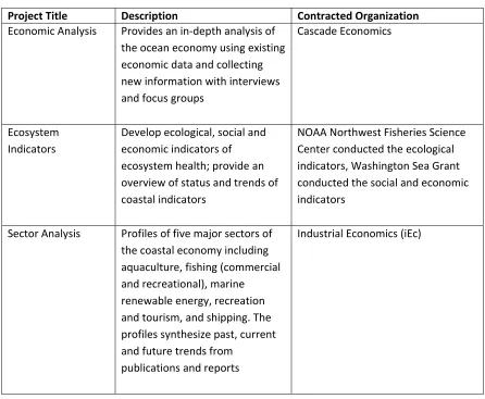
Numerous research projects are being conducted in order to integrate similar data, and to collect new data to address data gaps, for marine spatial planning. Some of these projects are designed to provide contextual information and do not have a spatial component, but are important for understanding the current state of the ecosystem required by the 2010 law. Contextual projects include an economic analysis, ecosystem indicators, and a sector analysis of the five major sectors of the Washington ocean economy. Mapped data layers include data sets that have been converted to GIS format or new spatial data layers that were developed using GIS tools. Examples include
bathymetric surveys, oceanographic modeling, seabird and marine mammal modeling, characterizations of commercial and recreational fishing, data on vessel traffic patterns, and identification of ecologically important areas (see Appendix IV for a full list of research projects).56
VI.
Potential Plan Outcomes and Implementation
A. Recommendations for New Uses
At the time of this writing, the Washington Coast MSP is still being developed and it is not yet clear what the final plan might look like or what types of outcomes or recommendations it might include.
potential for renewable energy with minimal potential for conflicts with existing uses or sensitive environments.57 The plan will evaluate and include recommendations for the following new uses: marine renewable energy (e.g. wind, wave); dredge disposal in new locations; aquaculture in new locations including offshore; mining or mineral extraction (e.g. sand, gravel, gas hydrates); and marine product extraction for cosmetic or
pharmaceutical uses.58
The use analysis that will inform these plan components is underway, but has not yet been completed at the time of this writing. From spring 2015 through winter 2016, the state will use GIS tools to conduct a use analysis to assess the potential spatial interactions between existing and possible new uses.59 This analysis will help inform spatial recommendations to include in the plan. Throughout the process, the planning team will provide updates to the WCMAC and solicit their recommendations and feedback for adjusting the analysis. Key steps for the use analysis include:
Ocean use representatives will provide input on the spatial data for their sector;
Using GIS tools, each of the data layers for individual existing ocean uses and important ecological areas will be compiled by sector into two sets of maps – intensity of use (where available) and footprint of use;
The sector data will be combined to produce overall maps of (1) intensity of existing uses, and (2) total number of uses; and
The existing use data will be compared to data for renewable energy potential to inform spatial recommendations.
Once draft maps are available, the planning team will seek additional feedback from the public.60
B. The Future: Plan Implementation, Monitoring, and Adaptive
Management
Research for this report was conducted during the ongoing planning stage of the Washington Coast MSP process — long before the implementation stage. Accordingly, this section presents planned future steps in the process and the planning team’s anticipated outcomes.
Planners anticipate that, when finished and approved, the Washington Coast MSP will be implemented using existing state authorities and regulations. Department of Ecology staff interviewed for this study explained that, since the MSP will include a
source for the best available science, it is likely to be used in decision‐making for future project proposals. In the event of a project proposal in the MSP study area, Department of Ecology staff explained that the state intends to use the plan as a supporting
document that identifies key issues and data gaps as well as the state’s authorities for that project area. The specific implementation framework measures are still under development. However, Department of Ecology staff Jennifer Hennessey explained that one possible approach to ensure state agencies incorporate the plan in their decision‐ making is to sign a memorandum of understanding.
Interviews with both MSP planning leaders and WCMAC representatives
indicated that they will plan to use the best available data to make recommendations in the marine spatial plan. However, as new information about the marine environment and specific project proposals becomes available, it will need to be considered and significant changes in information could prompt the state to revise and update the plan.61
An adaptive management strategy is a requirement of the MSP law and thus will be included in the plan. The MSP law states: “Subsequent to the adoption of the marine management plan, the [marine interagency] team may periodically review and adopt revisions to the plan to incorporate new information and to recognize and incorporate provisions in other marine management plans. The team must afford the public an opportunity to review and comment upon significant proposed revisions to the marine management plan.”62 WCMAC Chair Garrett Dalan concurred that updating the plan will be important:
“And even if everybody agrees that this is the good place for everything . . . how long? One year? Five Years? Ten years? How far out is a wind energy project if the energy companies are saying they aren’t interested and you’ve got all these other pushbacks, [so] we’ve got some time there. Meanwhile, what’s shown up off the coast? A great white shark shows up off the coast. Well, that’s kind of odd. Somebody catches this swordfish or marlin off Oregon. There’s some ocean changes going on. They could be global, they could be decadal, you’ve got El Nino, you’ve got the Pacific Decadal Oscillation, general climate change
possibilities . . . all these things that come into play and change so many things. . . . So it [the plan] could lose its value really quick. Its determinations could be bunk or misguided because of when they got their information. I can’t think of a comparable plan that has to be as dynamic.”
While a specific evaluation method has not yet been developed for the marine spatial plan and the MSP process, it is a requirement of the MSP law. The law states: “The director of the Department of Ecology, in coordination with the team, shall periodically review existing management plans maintained by the state agencies and local governments that cover the same marine waters as the marine management plan under RCW 43.372.040, and for any substantial inconsistency with the marine
management plan the director shall make recommendations to the agency or to the local government for revisions to eliminate the inconsistency.”63 The law also states that, within four years following adoption of the marine management plan, the
Department of Ecology, in coordination with the SOC, will provide a report to the Senate and House of Representatives that describes where existing management plans are inconsistent with the marine spatial plan and provide recommendations for eliminating any inconsistencies.64
Finally, marine spatial planning offers the state an opportunity to collect the information and provide the analysis needed to establish a Geographic Location Description (GLD). The GLD is a tool outlined in the federal CZMA through which states can enhance their federal consistency review over federal license or permit activities in a geographically defined area of federal waters. In a GLD, a state lists the federal licenses or permits for activities in a defined area that will be automatically subject to state CZMA review. Otherwise, a state would have to request approval from NOAA to review a proposed project in federal waters on a case‐by‐case basis.65 By collecting information for the marine spatial plan, the state is compiling strong evidence to show the state’s interest in federal waters within the MSP area and to demonstrate the reasonably foreseeable effects that federal licenses or permits could have on state coastal resources and uses. Interviews with the Department of Ecology staff indicate that the state plans to develop a GLD as part of the MSP process and submit it to NOAA for approval after the plan has been adopted by the state (Hennessey pers. comm.
VII.
The MSP Process to Date: Planning Challenges and
Stakeholder Concerns
A. The Functioning of the WCMAC
Many stakeholders interviewed for this study spoke about the challenges of working within the WCMAC, and some expressed skepticism about its ability to facilitate meaningful stakeholder engagement. Some attributed these challenges to the group’s change in status so soon after its establishment, and others attributed it to the fact that both stakeholders and government agency staff participate in the group. However, others noted that there have also been successes, and many credited the group’s chair with his ability to make things work. For example, Washington Sea Grant Director Penny Dalton commented, “The head of it [the WCMAC] is terrific; I think he’s been
responsible for a lot of the success.”
B. Stakeholder Concerns
Case study interviews suggested that one of the stakeholders’ primary concerns is that existing uses will be displaced as a result of new uses on the coast. The existing uses of fishing and shellfish aquaculture are a strong part of Washington’s coastal culture and economy. These uses largely contribute to how these communities define themselves –both their history and future. Stakeholders that are active in the MSP process have developed the phrase “Protect and preserve existing, sustainable uses” when describing the primary benefit they hope to gain from participating in the MSP process. WCMAC member Brian Sheldon explained: “I mean great, you’ve got a wind turbine out there, how are you going to get it [the electricity] to shore, and what it is going to displace? When I see maps like that, where you’ve basically displaced fishing, we don’t have a lot of fishing ground around here to displace anymore.” Interviews with planning team members indicate how they have tried to be very clear about setting expectations for the marine spatial plan and have let stakeholders know that continued participation in the process allows concerns to be reflected in the recommendations that are provided through the WCMAC (Hennessey pers. comm. December 21, 2015).
Another concern from stakeholders in the southern part of the coast that was revealed during interviews is that uses will be compressed into a smaller and smaller area due to new uses. Stakeholders interviewed for this study provide several
observations and considerations to support this concern, including the following:
Some stakeholders observed that the tribal “usual and accustomed areas,” which occupy most of the northern half of the coast, are closed to non‐tribal
commercial fishermen for segments of the fishing season. This tends to concentrate non‐tribal fishing in the southern half of the coast.
Some stakeholders expressed concern that the presence of the Olympic Coast National Marine Sanctuary in the northern half of the coast could direct proposed offshore energy and other development to the southern half of the coast. DFW staff Michele Culver explained this stakeholder concern: “This [southern] area is already not protected within a Sanctuary, so by showing that that would be the most suitable area for energy development, it’s causing some concern.” DFW Staff Corey Niles elaborated, “And that’s also the area where the Dungeness Crab fishery happens.”
Some stakeholders observed that renewable energy investors may be more likely to select a southern port – where the terrain is less rugged than the northern half of the coast – for easier access to power centers and population centers.
C. National Priorities at the Expense of Local Communities
Interviews also revealed that many stakeholders in local communities are generally skeptical of the federal government — particularly regarding issues related to natural resource management. Local communities are concerned that new uses on the coast will benefit regional urban centers with little or no measurable benefits to local, rural communities. Some stakeholders also fear that new uses may even harm an already economically poor region of the state.
WCMAC member Rich Osborne explained the distrust of government in both the northern and southern portions of the coast: “There’s one component on the coast, one cultural group that’s so anti‐government that I think it’s impossible for them to be able to work together . . . Up North, there’s a lot of sanctuaries and national parks that have decreased in value over the generations. So, there’s a generational distrust of federal government up north related to those projects. So, down South they hate the state government, whereas up North they’re more against the federal government.”