PROCEEDING
INTERNATIONAL CONFERENCE
Land Consolidation
as an Instrument to Support
Sustainable Spatial Planning
Supported by
National Land College
Proceeding International Conference:
Land Consolidation as an Instrument to Support Sustainable Spatial Planning © National Land College, 2017
First published (November, 2017)
by:
National Land College
Jl. Tata Bumi No. 5 Banyuraden, Gamping, Sleman, Yogyakarta, 55293
Tlp. (0274) 587239 Faxs: (0274) 587138
In collaboration with
STPN Press
Jl. Tata Bumi No. 5 Banyuraden, Gamping, Sleman Yogyakarta, 55293
Tlp. (0274) 587239 (ect. 115)
Author: Oloan Sitorus, Sukmo Pinuji, Westi Utami, Arif Suhattanto, Ferdy Nugraha,et al.
Editors: STPN Press Team Layout & Cover: nazir slm
National Library: Catalog in Publication Proceeding International Seminar:
Land Consolidation as an Instrument to Support Sustainable Spatial Planning National Land College, 2017
iii
In this era, sustainable development becomes ultimate goal of all development programs throughout the nations over the world. People start to realize that the develop-ment today should be able to fulfill recent needs, without compromising the needs of future generation. It is difficult to pin down the concept of sustainable development since it encompasses many different subjects and disciplines. Nonetheless, this concept is highly related with sustainable spatial planning in term of land allocation, regarding the limitation of available land, and increasing of the demand. In this context, land consolidation, as a part of spatial planning, has important role in arranging, revitalizing and allocating current spaces, without abandoning future needs. In Indonesia, rearrangement and revitalization of land tenure and land use through land consolidation has many advantages on spatial planning, both in urban and rural area. Land consolidation can be implemented in many aspects of spatial planning, such as city revitalization, vertical land consolidation for urban area, land consolidation for agriculture area to support food self-sufficiency, post-disaster land reconstruction and disaster mitigation, and land arrangement for certain area such as border zone, coastal area, riverbank area, and small and outer islands.
One of the consequences of globalization is the change of urban and rural area throughout the world, including Indonesia. Globalization boost up urbanization, leaving problems of traffic congestion, the emergence of slum areas, and the degradation of quality of life on social and spatial aspects. On the other hand, globalization also changes the rural area: it is abandoned, massive agriculture land conversion is inevitable, and it also loses its capabilities as urban buffer zone. Nonetheless, this condition seems inevitably. Statistic shows that by 2045, urban population is predicted as 82% from total number of population in Indonesia. This condition indicates that sustainable spatial planning for urban area is crucial. Land consolidation for urban renewal is needed to achieve inclusive city, and to improve capabilities of the city to adjust with those changes, whether from spatial perspective or social and economic. With the current state of urban growth, land conso-lidation is needed to readjust land utilization, use, tenure and ownership, specifically in developing country such as Indonesia.
iv Proceeding International Conference
One of the parameter of sustainable development also requires sufficient national food production. Food resources are crucial to ensure food security for a nation. This condition can be achieved through agricultural intensification by implement efficient technology, or by agricultural extension through agricultural expansion. Food security requires sufficient agricultural area, both in its quality and its extent. The biggest threat of agriculture land conversion is shifted into commercial area, and commonly occurred in almost all part of the world. Land conversion is closely related with urban sprawl. As consequences, the need of land around the city increased dramatically. Sprawl is characterized by urban growth that tend to be irregular (spotted), heading to the suburb, with the tendency of discontinuity as the result of land subdivision, and affecting agricultural area. In regard with sustainable development, shifting of land use change from agriculture to non-agriculture area should be considered by the government. The Government Regulation Nr.1/2011 on conversion of agricultural area into non-agricultural for sustainable agriculture area has been affiliated those needs. It is also emphasized in the Regulation of the Ministry of Agrarian Affairs and Spatial Planning/National Land Agency Nr.19/2016 on the Establishment of sustainable agricultural area for area that has not yet has spatial planning. Regarding this, land consolidation in agriculture area can be implemented as a tool to protect agriculture land conversion to achieve food security. By implementing land consolidation, agriculture area can be re-designed and re-adjusted to improve efficiencies on food production, increase farmer’s income, and prevent conversion.
Not only for urban and rural re-adjustment, land consolidation can also be implemen-ted for specific purpose such as post-disaster reconstruction. Locaimplemen-ted within ring of fire’ zone, Indonesia has high risk to experiences natural disasters such as earthquake, volcanic eruption and tsunami. Tsunami in Aceh in 2004, or Mt. Merapi eruption in 2010 giving best examples on how land consolidation can be implemented to reconstruct land after disaster, and to revitalize spatial planning function to be more adaptive on disaster mitigation. Land right reconstructions were carried out together with land consolidation, resulting more efficient spatial arrangements which also adaptive for disaster mitigation1.
Indonesia also characterized by an archipelago nation. It has 13.466 islands that have
1 Land consolidation for post-disaster reconstruction has been done in Indonesia. After Aceh tsunami in 2004,
Small islands, however, with its distinctive characteristics, need spatial planning adaptive for global warming and climate change. However, re-adjustment of specific areas through land consolidation such as coastal area, small islands, state-border area and outermost islands is considered important for sustainable spatial planning to ensure national security and state’s sovereignty.
In conclusion, as part of land management and spatial planning, it is important to set up agenda able to accommodate land consolidation for various purposes. National Land College, in collaboration with Directorate of Land Consolidation, Ministry of Agrarian Affairs and Spatial Planning, commit to hold an international conference as a way to achieve that. International Conference of Land Consolidation as an Instrument to Support Sustainable Spatial Planning is a forum to disseminate ideas, findings, policies and empi-rical experiences related to land consolidation for urban renewal, vertical land consolidation (VLC), sustainable agricultural area, post-disaster reconstruction, and specific area such as state-border, riverbanks, small islands, outermost islands, and coastal area. Exchanges and sharing of knowledge and experiences within experts, academia, researchers and practi-tioner are expected will be useful for the decision makers to set up programs and policies related to the topic.
By this conference, we hope that sharing ideas, findings, critical thinking and experien-ces from participants with different backgrounds and expertizes can contribute to the development and improvement of land consolidation in Indonesia for better living improve-ment for everyone. Lastly, we hope you enjoy this program, and bring back many advan-tages from what we learn from this conference.
vi
CONTENTS
Greeting from the Committee iii
Sub Theme 1: LAND CONSOLIDATION IN LAND AND SPATIAL PLANNING STUDIES
Susiyowati Indah Ayuni Endo Foury Lovenda, Lidya Nur Hanifati
Diponegoro University, Semarang
Community-based Peri-Urban Land Cosolidation by People for People in Kampung Bubakan, Kandangan Village, Bawen Subdistrict
The Application of Land Consolidation as an Instrument for Transit Oriented Development in Development of Public Facilities. Case Study : Lebak Gede. Lebak Siliwangi, and Cipaganti
54
Impact of Land Consolidation to the Socio Economy of Landowners in Road Poject of Tohapti-Gianyar and Kuta-Kerobokan Bali System in Upper and Lower Ground Spatial Planning
The Role of Community Participation and Spatial Data on Vertically Land Consolidation Program in Managing Slum Area
Sub Theme 3: AGRACULTURAL LAND CONSOLIDATION TO SUPPORT NATIONAL FOOD SCURITY
Susilo Widiyantoro
Gadjah Mada University/Kantor Pertanahan Kab. Gorontalo Utara
Challenges of Agricultural Land Consolidation in Yogyakarta Urbanized Area
131
Aditya Mulya
Ismawardani Novia Dewi
University of Indonesia
Projection of Land Suitability of Rice Field Based on Representative Concentration Pathways (RCP) 4.5 Scenario in Bojonegoro Regency
142
I Dewa Gede Agung Diasana Putra
Universitas Udayana, Bali
Social Impact Assessment as an Instrument to Maintain Resilience of Socio-Ecological System in Security in Badung and Gianyar Districts of Bali Province
169
Sub Theme 4: LAND AND SPATIAL PLANNING FOR SPECIFIC AREA (POST-DISASTER, COASTAL ZONE, STATE BORDER, SMALL ISLAND AND OUTER ISLAND
Sukmo Pinuji Lesson Learning from The Great East Japan Earthquake of Higashi-Matsushima City, Miyagi Management: A case Study in North Jakarta Coastal Area
195
Azizah Dewi Suryaningsih
Diponegoro University, Semarang
Bamboo Clumps as A Natural Barrier of Volcano Pyroclastic Flows (Volcano Mitigational System in Khendil’s (ill, Post-Disaster Area of Merapi Volcano)
Land Consolidation For Merapi Slope Area After Merapi Eruption From Local Wisdom Perspective
229
Westi Utami
National Land College, Tata Bumi 5 Yogyakarta 55293, Indonesia
Land Consolidation as a Solution for Densely Populated Area (Case study in Kotagede Yogyakarta)
3
COMMUNITY-BASED PERI-URBAN LAND COSOLIDATION
BY PEOPLE FOR PEOPLE IN KAMPUNG BUBAKAN,
KANDANGAN VILLAGE, BAWEN SUBDISTRICT
Susiyowati Indah Ayunia, Endo Foury Lovendaa, Lidya Nur Hanifatia aDiponegoro University, Jl. Soedarto, SH, Semarang 50275, Indonesia
Abstract
A city in the process of development will always continue to growth. The increasing number of people automatically increasing the land needs and peri-urban becomes a part of the cities. Semarang–Solo Toll road construction forced the people to move and conduct new settlements in designated area. The procedures of land consolidation basically has been used by a large of area and adopted by the state through the reduction of land fragmentation. Neverthless, people in that area create and develop their own unique strategies, which is considered to be an effective distribution system. This indicates that formation of traditional land consolidation until today can be identified its existence. For that, we need to know the analysis underlying the implementation of traditional land consolidation in Peri-Urban area in Kampung Bubakan through its society and physical aspects. The methodology used in this study are statistic through the calculation of land also the visualization of before-after 2D spatial land plot model that aims to create and overview and systematically description about traditional land consolidation. The result obtained from this study are some findings 1) The explanation of the land consolidation problem roots; 2) Knowing characteristics of toll-affected communities; 3) Traditional land consolidation sketch and calculation; 4) Forming the concept and strategies of unique traditional land consolidation implemented by the people. These findings can be used as reference and key instrument for applying land consolidation in similar area or society.
Keywords: Traditional Land Consolidation ; Residental ; Peri-Urban ; Concept ; Bubakan Village.
1. Introduction
4 Proceeding International Conference
More toll roads are built to connect cities and its surrounding areas (Chung, 2002). On the other side, toll road construction as a part of infrastructure development has an impact on physical environment. The most visible thing is the occurrence of land use changes where the land and its settlement that used as a toll road having its own compensation. Construction of Semarang–Solo Toll Road, especially section II Ungaran–Bawen has changed the face of space in Kandangan Village. The landscape of Kandangan Village has changed significantly since 2011 due to construction of toll roads. The land acquisition process has forced community settlements to move and conduct other areas to live. This resettlement is the forerunner to the formation of a new settlement called Kampung Bubakan, whoce entire community is affected by the 2nd section of Ungaran–Bawen Toll Road in 2011.
The process of land acquisition in Kampung Bubakan involves the land consolidation that done traditionally by the community itself. Land consolidation activites seek to restructure the existing of land resources (Long, 2014). Land consolidation is a land management program that is considered to overcome the problems and accelerating urban development. Land consolidation arranges land ownership so that it can be well organized and improve the use of the land due to irreguler land become regular and rectangular (Idham, 2004; Parlindungan, 1984). The process of forming the settlement is done by community itself without any interference from government. Communities and local elites took the initiative to rebuild their settlements. They independently arrange the land and as a group they consolidate rural settlement lands.
This study attempts to examine the procedure and concept of Kampung Bubakan community in the process of land use arrangement through simple land consolidation. The method used in this study is statistic calculation to identify land use change and spatial plot model visualization both before and after traditional land consolidation by Kampung Bubakan community. Results in this study divided into five parts, 1) Knowing the characteristics of community affected by toll roads construction and the roots of land consolidation problems; 2) Establishing traditional land consolidation concepts and strategies adopted by community; 3) Visualizing model of land changes between 2011 and 2017; 4) Explaning the result and study findings; 5) Conclusion.
2. Material and Methods
2.1. Study Area
The scope of the study area in Kampung Bubakan RT 01 RW 03, consisting of 43 families with 163 total population. This Kampung is a new settlement resulted by the formation of the community resulting from the construction of toll roads, which developed by the community into a large area that formed a new settlement center that attracts the growth of social economic activities. Administratively, Kampung Bubakan is located in Bawen Subdistrict, Semarang Regency, but functionally the existence of Kampung Bubakan inseparable from the existence of Semarang City, where most of the population have livelihood in Semarang City. The emergence of residental areas in Kampung Bubakan is an anticipatory step from the government to control the physical growth at toll road. As a peri urban area, this region is unique, because it consists of urban and rural characteristics. The development of peri-urban area is characterized by changes in rural life activities to urban areas (Budiyantini & Pratiwi, 2016). Kampung Bubakan has been established for 5 (five) years after the relocation of settlements due to the construction of Section II of Ungaran– Bawen Toll road. Kampung Bubakan formerly a agriculture land that is only owned by 3 (three) residents, but now its designation has been functioned as land building by all communities of Kampung Bubakan.
2.2.Social Economic Analysis
In the early stages, an explanation of the socio-economic characteristics of affected communities by deepening the question of the community perseption in the context of land consolidation to minimize bias in its application, and how the tolerance between communities and the root causes of the consolidation process is not in accordance with the established provisions, according to people’s preference for fair land consolidation.
2.3. Statistic Analysis of Land-Plot
Changes in land owner, that visualized in Kampung Bubakan in 2011 and 2017 that presented in map model, and features with statistic analysis in Land-plot that presented in table. Statistic descriptive is adopted in analysis, which is an attempt to describe the various important societal characteristics of organized data (Santoso, 2003). Finally, changes in land consolidation from each owners are described. The results of statistical analysis can answer the usefulness, effectiveness and impact of land consolidation in Kampung Bubakan.
2.4.Traditional Land Consolidation Strategy Analysis
6 Proceeding International Conference
consolidation stage implemented by the Kampung Bubakan community. The result of data processing is presented in chart, so it can be eaily known pattern that formed.
3. Result and Discussion
This study attempts to find the concepts and strategies undertaken by Kampung Bubakan community in the process of establishing new settlements through simple and traditional land consolidation activities. The first analysis activity is to know the characteristics of Kampung Bubakan community and the new settlement that formed. Secound is an analysis of concept and strategy used by communities in land consolidation process, and the last is spatial analysis to identify changes in land use both before and after tradisional land consolidation.
3.1. Kampung Bubakan Community Characteristics
Kampung Bubakan is a newly formed settlement for 5 (five) years due to the relocation of settlement affected bt the Section II Ungaran–Bawen toll road in Geneng Neighborhood (RW III), Kandangan Village, Bawen District. This Kampung is actually categorized as an unplanned sattlement, Kampung Bubakan has a various slopes that do not have adequate drainage systems that are particularly susceptible to landslides (Anderson, Holcombe, & Renaud, 2007). Although peri-urban area, Kampung Bubakan is still dominated by rural activities. As a region that categorized as rural-area, Kampung Bubakan is a social unit that reflects the strong relationship between environment and people, has a historical background, and sociopolitical relationship (Robinson, 2003; Yang, Xu, & Long, 2016). This indicates that Kampung Bubakan is characterized by strong cohesion and coordination among individuals in community groups and high mutual coorporation.
The total population in Kampung bubakan consists of 43 families which are all affected by the toll roads construction. Based on economic perspective, mayority of Bubakan communities work as laborers, especially for young age groups and among women, and rarely worked as farmers in the fields, only a few group who owned a agriculture land. The average community of Kampung Bubakan is classified as KS II (middle to lower society) with their income and the result of compensation from the process in land payment from the toll construction project. They can not freely choose where they will build their new home. Low preference for land tenure causes communities to jointly buy land on moderate sclopes (25% - 40%).
Figure 1. (a) Land use of Kampong Bubakan in 2011; (b) Land use of Kampong Bubakan in 2017
3.2. Concept and Strategy of Kampung Bubakan Land Consolidation
The same process soil consolidation with the land adjustment process in Kampung Bubakan will generally be divided based on accessibility factor and topography. Accessibility is one of the factor that makes a land more valuable, areas with good road accessibility have a value of land above average. Accessibility is used to refer to the ease with which the land uses and transportation systems enable individuals to reach activities or destinations (Du & Mulley, 2012). The value of accessibility is measured by looking at the distance of the land location to the road. While the high topography tend to have the potential to landslide disaster, difficult access to the location, that cause less in demand. Accessibility and topography during the consolidation process will affect the extent of land plots that will be obtained by landowners, where areas with easy access or close to the road network will obtain smaller landholdings compared to areas that do not have access to the plot location. As with accessibility, the more flatter the topography of the area in Kampung Bubakan, the smaller the land the landowner will acquire. This is considered fair by most of the population. In contrast to the consolidation system that has been applied to other areas, the determination of the land area also takes into account the extent of residential shelter previously owned by each resident. This is because, the private sector PT. Trans Jateng has considered the replacement of land, buildings, and each tree in the house. A key factor in the land consolidation strategy undertaken in Kampung Bubakan is the role of local champion where the involvement of communities through participation in the process of consolidation of traditional land is able to fulfill the wishes and the results are considered fair by them (Liu, Müller, Rommel, & Feng, 2016).
8 Proceeding International Conference
Pra- Land Consolidation Land Consolidation On-Going
High-Coordination Low-Coordination
Figure 2. (a) Pra-Land Consolidation; (b) Land Consolidation On-Going
In pre-consolidation of land, the private sector coordinates to all parties, that are the village head, the neighborhood chief, and the neighborhood groups to convey information to the residents, while the private sector provides reimbursement of funds to residents affected by toll roads. The replacement is in the form of land compensation, building on land, and trees. So that the private sector is inactive at the time of pre-consolidation or during the consolidation in Kampung Bubakan, and there is no government involvement in the process.
The process of dividing the land in Kampung Bubakan looks very easy and simple. The division of land plots is entrusted to one person through a joint discussion process. The high cost of formal consolidation process, especially if land consolidation involves additional infrastructure and new residential development, new efforts are made to lower costs by introducing acceleration schemes (Burton, 1983). The absence of government involvement and community independence in the consolidation process shows that legislation in Indonesia provides an opportunity to facilitate the consolidation process in accordance with the community desires. For more details, this is the stage of land consolidation applied by Kampung Bubakan community.
Figure 3. Land Consolidation Process in Kampung Bubakan
3.3. Calculation Result of Traditional Land Consolidation in Kampung Bubakan Land consolidation is considered as a land management program that can overcome problems. Therefore, formulating a common agreement becomes a challenge that needs to be given more attention. The success of this program is the arrangement of land ownership, so the land is more organized. With the arrangement of ownership, the existing barriers can be more easily to overcome (Idham, 2004). It has been elaborated, the process that took place in Kampung Bubakan was very simple and easy to perform, the process being conducted was a process of discussion and deliberation together to get an agreement on the fair share of land plot. From the 4 plots of land owned by Mr. Sutikman, Darto, Yusuf Basri and Mundari which is moor land are positioned as inputs in the process and carried out a consolidation of land consisting of 43 Head Families (Figure 4.)
10 Proceeding International Conference
Figure 4. (a) Land use of Kampong Bubakan in 2011; (b) Land use of Kampong Bubakan in 2017
Table 1. Calculation of Traditional Land Consolidation by People of Kampong Bubakan Land
Nb: out plots totaling 43 plots and the rest of the land are used for roads, drainage and mosque
The results show that the old land owners did indeed decrease the size of the land in size of output after the land consolidation, while the new landowners experienced an increase in output size. However, when viewed in terms of benefits received by old land owners get the payment Rp 250,000.00/m2. While new landowners are required to replace the land by paying the land price (so the benefits are negative). This indicates that the new landowners get the benefits of new land tenure while the old land owners get a compensa-tion in the form of money. To support Kampung Bubakan settlement activity, the commu-nity was handed over to the public utilities (include facilities and infrastructure) of 2.794 m2
for the construction of musholla, road network and drainage network. The land consoli-dation process is very simple, and easy to do by the community. The main key of success of land consolidation are social cohesion and high social capital in Kampung Bubakan. They prefer to trust their own community leaders rather than outsiders to petrify themselves in the process of dividing the land plot, due to convoluted. This process is legitimate and can be implemented if it is still within a relatively small scope and with a small number of land consolidation members.
4. Conclusion
Land consolidation is a policy that supports development and has a function to accele-rate the distribution of facilities and infrastructure. However, in Kampung Bubakan as a peri-urban area with dominant rural characteristics, the community has their own method to consolidate of trasitional land from people by people. The process of land consolidation has a driving force in the form of development toll road infrastructure section II Ungaran– Bawen that forced people to move and conduct their old land and form new settlements. The result of land consolidation of traditional land by the community shows that the concept and strategy that used by people is very simple and easy to do. The basis of the process that used is mutual trust between stakeholders and the role of local elite (Chief of Neighborhood/Group of Neighborhood) which becomes the key determinant of the sucess-ful land consolidation process in Kampung Bubakan.
12 Proceeding International Conference
process in accordance with their wishes, although the process as not perfect as its rules that has been established.
Acknowledgements
This study is supported by Urban and Regional Planning Engineerng Diponegoro University which has smoothed all affairs related to our study. In addition, this research is assisted by Mr. Sariffuddin, S.T, M.T as a supervisor who provides consultation and direction so that this study can take place well. Also all parties who can not be mentioned for helping and providing indirectly support so that this study can be completed properly.
References
Alnsour, J. A. (2016). Managing urban growth in the city of Amman, Jordan. Cities, 50, 93– 99. https://doi.org/10.1016/j.cities.2015.08.011
Anderson, M. G., Holcombe, L., & Renaud, J. P. (2007). Assessing slope stability in unplanned settlements in developing countries. Journal of Environmental Management, 85(1), 101–111. https://doi.org/10.1016/j.jenvman.2006.08.005
Budiyantini, Y., & Pratiwi, V. (2016). Peri-urban Typology of Bandung Metropolitan Area. Procedia - Social and Behavioral Sciences, 227(November 2015), 833–837. https://doi.org/10.1016/j.sbspro.2016.06.152
Burton, S. P. (1983). Land Consolidation and Changes in the Agrarian Landscape of Cyprus. Leicester: Leicester University Geography Department Occasional Paper 10.
Chung, H. (2002). Some socio-economic impacts of toll roads in rural China. Journal of Transport Geography, 10(2), 145–156. https://doi.org/10.1016/S0966-6923(02)00007-8 Du, H., & Mulley, C. (2012). Understanding spatial variations in the impact of accessibility on land value using geographically weighted regression. Journal of Transport and Land Use, 5(2), 46–59. https://doi.org/10.5198/jtlu.v5i2.225
Idham, H. (2004). Konsolidasi Tanah Perkotaan dalam Persepektif Otonomi Daerah. Bandung: PT. Alumni.
Janus, J., & Markuszewska, I. (2017). Land consolidation ??? A great need to improve effectiveness. A case study from Poland. Land Use Policy, 65, 143–153. https://doi.org/10.1016/j.landusepol.2017.03.028
Liu, Z., Müller, M., Rommel, J., & Feng, S. (2016). Community-based agricultural land consolidation and local elites: Survey evidence from China. Journal of Rural Studies, 47, 449–458. https://doi.org/10.1016/j.jrurstud.2016.06.021
Natarajan, L. (2017). Socio-spatial learning: A case study of community knowledge in participatory spatial planning. Progress in Planning, 111, 1–23. https://doi.org/10.1016/j.progress.2015.06.002
Ning, G., & Qi, W. (2017). Can self-employment activity contribute to ascension to urban citizenship? Evidence from rural-to-urban migrant workers in China. China Economic Review (Vol. 45). Elsevier Inc. https://doi.org/10.1016/j.chieco.2017.07.007 O’Brien, J. 014). Shaping Knowledge Complex Socio-Spatial Modelling for Adaptive
Organizations. Oxford: Chandos Publishing.
Parlindungan, A. P. (1984). Komentar Atas Undang-Undang Pokok Agraria. Bandung: Alumni.
Prabowo, D. (2017). Lebaran 2018, Seksi 4 dan 5 Tol Semarang-Solo Bisa Digunakan. Retrieved January 1, 2017, from properti.kompas.com
Robinson, P. S. (2003). Implications of rural settlement patterns for development: A historical case study in Qaukeni, Eastern Cape, South Africa. Development Southern Africa, 20(3), 405–422. https://doi.org/10.1080/0376835032000108202
Santoso, S. (2003). Statistik Deskriptif. Yogyakarta: Andi.
Simorangkir, E. (2017a). Ini Daftar Jalan Tol yang Dibangun Era Soeharto Hingga Jokowi. Retrieved January 1, 2017, from finance.detik.com
Simorangkir, E. (2017b). Tak Darurat Lagi, Tol Semarang-Solo Bisa untuk Mudik 2018. Retrieved from finance.detik.com
Skog, K. L., & Steinnes, M. (2016). How do centrality, population growth and urban sprawl impact farmland conversion in Norway? Land Use Policy, 59, 185–196. https://doi.org/10.1016/j.landusepol.2016.08.035
Tian, L., Ge, B., & Li, Y. (2017). Impacts of state-led and bottom-up urbanization on land use change in the peri-urban areas of Shanghai: Planned growth or uncontrolled sprawl? Cities, 60, 476–486. https://doi.org/10.1016/j.cities.2016.01.002
Xie, R., Fang, J., & Liu, C. (2016). Impact and Spatial Spillover Effect of Transport Infrastructure on Urban Environment. Energy Procedia, 104, 227–232. https://doi.org/10.1016/j.egypro.2016.12.039
14
ECO-FRIENDLY URBAN DEVELOPMENT BY LAND CONSOLIDATION
IN JAPAN MANAGEMENT METHOD OF PRIVATE IMPLEMENTATION
Kunika Mizuno*
Tamano Consultants Co., Ltd
Abstract
This paper explains the system of land consolidation (LC) in Japan and analyzes management methods for successful eco-friendly urban development by private implementation. In Japan, LC project consists of three elements: 1. Land re-plotting; 2. Provision of infrastructure; 3. Self-financing by selling reserve land. This integrated system covers project effectively. As for the implementing body, besides the government sector, the private sector (organized by landowners) is one of the main implementers in Japan. One characteristic of private implementation is that residents have authority over the decision-making for the project. However, there are not many cases in which landowners take voluntary action through an LC project. Generally, such projects are hindered because of difficulties in raising funds from the project itself. In that sense, the case of the Nagakute Nanbu Area project was successful. The area is located in Nagakute City, which adjoins a central industrial city named Nagoya City. The new town development, cultivated by farmland and forests, aimed to preserve natural resources from the planning stage. Through the project, landowners engaged in natural resource conservation and its related maintenance. As for the analysis, this paper focuses on a management method by private implementers. Data was collected from project reports and interviews with stakeholders. Finally, this paper mentions some challenges to applying eco-friendly urban development by private implementers in other project areas.
Keywords: Integrated project system, private implementer, natural resources, financial management
1. Introduction
1.1. City planning and Land consolidation in Japan
A land consolidation (LC) project in Japan is defined as a project to improve public facilities such as roads, parks, and rivers to encourage the utilization of residential land by arranging the plots of land in an urban planning area. Early LC projects, which were developed based on the German LC method and Japanese adjustment of rice fields method, were legalized in 1954. Today, the number of implemented LC projects in Japan spans 8,500 districts nationwide. The reason they have been implemented in so many areas is because of the versatility of the method. For example, regarding topography, it is possible to adapt the method from a hillside to a flat area, even for a water reclamation plot. As for the situation of urbanization, it is applicable to both vacant lots and densely built areas.
Looking back on representative modern developments in Japan, LC has played an important role in large-scale development. This is especially true for the earthquake reconstruction following the Great Kanto Earthquake of 1923, the Nagoya Reconstruction
Project after World War II, and the development boom of urban areas between the 1950s and 1990s. However, both the number of projects and total area of LC have been decreasing in recent years. The rate of the decrease is remarkable after 2001 (Annual Report on Land Consolidation, 2016).
Although LC projects in Japan are in a transition period, it is necessary to conduct projects by adapting to the trends and techniques of the latest developments. Also, further applicability is expected in many countries under the different social and geographical conditions.
1.2. Problems of current LC from the point of view of nature conservation
The topic of this paper is environment-conscious city planning, which has received much attention in recent years in Japan. For example, the representative movement in national policy is a formulation of Sustainable Urban Redevelopment Guidelines-Mini Assessment in Urban Redevelopment,” which summarizes a voluntary environmental assessment regarding efforts such as the reduction of greenhouse gas emissions, reduction and proper disposal of waste, and mitigation of the heat island phenomenon” on urban redevelopment operators in 2008 (Ministry of the Environment) and a formulation of A Low-Carbon City-Making Guideline” to encourage local governments involved in urban development to reduce greenhouse gas emissions in 2010 (Ministry of Land, Infrastructure, Transport, and Tourism).
Meanwhile, at the regional level, interest in environment-friendly city planning has increased. For example, through biodiversity preservation and natural resource preservation activities, local people have tried to improve the environment and increase land value in the area.
However, there is some question about nature preservation in a LC project. Although it is necessary to conserve green spaces for urban residents, agricultural land, forests, and hilly land have disappeared because of the construction of new town in the suburbs. It was occurred especially after the war, during the period of high economic growth, which saw a
16 Proceeding International Conference
housing shortage caused by population increase. As a reflection of this problem, there have been some recent cases of design and construction using existing natural terrain and trees as is” in LC projects. In addition, residents sometimes engage in nature conservation in the LC project area. As an example, in the Aoba Utsukushigaoka Central Area in Yokohama City, Kanagawa Prefecture, a policy of greening” of the district plan was established, and the residents are involved (home page of the Utsukushigaoka Association).
Regarding nature conservation activities in an urban development area, there are previous studies and discussions. For example, Shimao et al scientifically analyzed the important factors that encourage organized activities by residents (Shimao et al., 1993). As for the same activities in a LC project area, research was conducted by Sawai (2016). He provides an outline and mentions the significance of the conservation of green spaces by landowners in the Nagakute Nanbu Area. However, the previous research does not provide an analysis of how to apply this management model to other LC project areas. Therefore, the purpose of the analysis in this paper is to consider two aspects of a project’s sustainability: One concerns the financial management of the nature conservation activity; the other concerns an effective method to ensure the human resources for the activities.
As a supplementary analysis, the Indonesian LC project situation, which has no previous projects implemented by a private party, should be considered. However, it is sufficient to take this analysis as a reference for the promotion of landowner-oriented LC projects in Indonesia.
1.3. Research question, research method and outline of the paper
This paper considers the point at which private implementation is suitable for promoting nature conservation activities. In the case of the Nagakute Nanbu Area, Sawai points out that The idea of natural conservation by landowners was appropriately incorporated into the plan from beginning of the project. Then, activities such as taking care of plants and offering the experience of nature to children contributed to eco-friendly city planning.” Therefore, through the following two points, this paper sets an arguing point regarding the management method of an LC project:
A. It succeeds in subsidizing the activity funds from the LC project.
This assumption focuses on the sustainability of the financial management.
B. It succeeds in organizing voluntary activities through the LC project and shifts to other organizations after the project is finished.
This assumption focuses on the sustainability of human resources.
Hajime Hirano and Ryo Sawai of the Tamano Consultants Co., Ltd. Throughout this paper, excerpts from these interviews are identified as (personal communication).
The structure of this paper is as follows: Section 2 explains the basic Japanese LC system and packaged finance system, which sells reserve land to meet expenditures and conduct infrastructure provisions. This section also mentions the types of implementing bodies and the characteristics of private implementation. Section 3 introduces the Nagakute Nanbu Area LC project as a case study. It also describes some activities related to nature conservation by landowners in order to examine the stated arguing point. First, it analyses the method of disposing of reserve land to raise funds for the project. Then, it analyses forms of voluntary activity by landowners and the transition of the organization after the LC project is finished. The final section summarizes the content of the paper. It also refers to some points that are helpful for introducing voluntary initiatives by landowners for project management in Indonesia.
2. Land Consolidation Projects in Japan
2.1. Basic system of LC in Japan
18 Proceeding International Conference
Figure 2. Overall Structure of land consolidation system (Matsui, 2014)
2.2.Private Implementation of land consolidation project • Achievements of private implementation
This section describes the features of private implementation, which has had many achievements over the years in Japan.
Among the implementing bodies stipulated in the Land Readjustment Law, the main ones are local governments, such as prefectures and municipalities; Minister of Land, Infrastructure, Transport, and Tourism, urban revitalization organization; and government corporations; private implementer1 organized by more than seven landowners; individuals
organized by fewer than seven landowners; and land consolidation companies. With reference to the project areas approved by each implementing body since the 1970s, the number of private implementers is the largest in decades (Fig. 3). In particular, the number of areas reached 1551 in the 1970s, 1415 in the 1980s, 1440 in the 1990s, 606 in the 2000s, and 100 from 2010 to 2016 (Annual Report on LC Projects, 2016).
Figure 3 The number of project areas and calcification by implementation body
• Things to be done by landowners during a LC project
In the case of private implementation, landowners have authority over project decision-making. In the preparation stage of the project, representatives consist of landowner volunteers. They explain the outline of the project to other landowners and obtain consent for the implementation of the LC project. After obtaining consent, seven or more of the landowners jointly apply for an approval application and establish a legal association (kumiai, 組合) (Article 14 of the Land Readjustment Method). When the project starts, the general assembly established by the association has the right to decide various matters, such as changes to the project plan, basic policies, and the expense budget. Because the representative association also has the role of reporting project progress and communi-cating with landowners, it holds information briefing meetings from time to time, to distribute news about project progress.
• Importance of the reserve land disposal method in private implementation
In the section of this paper that describes the basic LC system in Japan, it was mentioned that a reserve land is established using landowner-contributed land. In the case of a private implementation, the authority to dispose belongs to the landowner. Therefore, they need to consider effective sales methods for the project. A well-known method of disposal is to cooperate with custom home builders in order to design effective road settings, such as community roads. In other cases, they try to attract commercial facilities in order to sell large plots. Such methods are often supported by specialized consultants.
3. Analysis on Sustainable Project Management by Case Study
3.1. Outline of Nagakute Nanbu LC project
• Outline of project area and changes prior to project implementation
The Nagakute Nanbu Area is located in Nagakute City, Aichi Prefecture. The popula-tion of Nagakute City is around 56,000, and this number has increased within the past decade (Statistics of Nagakute City, 2017) because of its strategic location adjacent to a central industrial city, Nagoya City.
20 Proceeding International Conference
Picture 1 Bird’s eye view of the area before and after project (taken by Nagakute Nanbu LC Corporative)
In planning the project, the concept of "Town Designed to Invite its Residents to Walk Around" was established by the landowners, who aimed to achieve an environment-friendly community. Specifically, the plan included a water park, pocket park, and green road.
• Nature conservation activities during LC project
The activities started with the idea of establishing a community that takes care of nature with the residents’ help after the LC project is completed. A flower-planting event was held by some landowners for the first time in 2009. Over time, this evolved into other activities and attracted new residents in the LC project area. Such activities can be classified into the following four categories: 1) Activities related to green space conservation; 2) Activities related to biological conservation; 3) Activities related to green space maintenance and management; 4) Activities related to regional cooperation. Specific details of these activities are shown in the figure in the appendix (personal communication) (see Appendix A).
Picture 2 . (From left side) Conservation of village-vicinity mountain activity. Picture 3. Biology conservation activity.
• Achievements of LC project
from 239 to 4,207. Because of the population increase, a new elementary school was opened in 2008, and a new nursery school was opened in 2014.
Looking at the natural environment conditions in the area, almost 9%2 (or 9.4 ha) of
the area is maintained as parks and green spaces. However, the usage of the natural environment in the area changed drastically compared with the previous situation. Forests and wild lands, which local people could not use in the past, have been developed into parks and green spaces where residents can relax, experience biodiversity, and play (personal communication). In this way, it can be said that the attractiveness and value of the area has improved as a result of the landowners’ activities.
3.2. Analysis of point A: financial management of reserve land disposal
This section and the next section examine the two hypotheses raised in Section 1.3 to consider a project’s sustainability. Augmenting point A is It succeeds in subsidizing the activity funds from the LC project.” Consequently, the research analyzed how the funding of nature conservation activities was subsidized by the LC project and how the funding was utilized.
Table 1 shows that the income from reserve land disposal reached 13.9 billion yen and accounted for about 67% of the total. It can be said that most of the funds for nature conservation activities were also obtained this way.
Table 1 Classification of amount of LC project amounts (yen) National subsidies 4.300,000,000 City subsidies 2.200,000,000 Reserve land disposal 13.900,000,000
Others 400,000,000
Total 20,800,000,000
• Strategic method for reserve land disposal
Mizuno, the chairman of the private implementation in the Nagakute Nanbu Area, notes that the following efforts were effective (Mizuno, 2006) Classifying the block of land into three land uses: A center district for commercial facility, an eco-residential area, and an industrial area. Then setting up reserve lands at the project planning stage; 2) Establishing reserve land sales committee by the chairman, director, and deputy director in order to grasp the end user’s orientation; 3) Changing the project plan according to a market survey performed by the committee. As a result, businesses such as a supermarket, drug store, and book store were started in the center district. Newcomers began to live in houses in the
22 Proceeding International Conference
residential area, and a large-scale building supply store opened in the industrial area. It can be said that the project succeeded in the sale of reserve land by establishing the appropriate reserve land in each area.
However, it should be noted that this fund-generating method was not planned for nature conservation activities (personal communication). When the LC project was launched, the Japanese economy was in a downturn, and it was predicted that the financial management would be difficult. Therefore, a policy for effective reserve land disposal was set up by the landowners. However, the policy succeeded in securing more profit than expected, resulting in a surplus. Because of this, it was possible to subsidize nature conservation activities.
3.3. Analysis of point B: Organization of landowner activities and sustainability Arguing point B is )t succeeds in organizing voluntary activities through the LC project and shifts to other organizations after the LC project is completed.” Therefore, this section considers the organization process of the landowners’ nature conservation activities through LC project management and the transition into other associations after the project.
Regarding the organization of landowner activities, as mentioned in Section 3.1, there were landowners who undertook nature conservation from the beginning of the LC project. Therefore, those landowners established the division of nature conservation activities and began those activities during the project. However, since 2009, when the LC project came to an end, the problem arose of how to continue the activities after the project finished. Then, they examined the possible transition to other organizations. As a result, the transition to a general incorporate association (Ippan shadan hojin, 一般社団法人) Nagakute Minami Satoyama Club” was established. There were about 13 members, including the landowners at the outset, which increased to about 50 members in 2017 (personal communication). Currently, funding for the activities is covered by a commission fee of 2 million yen from the Nagakute City for green space management work.
Besides the activities of the association, there was a characteristic effort related to daily activity. One example is the creation and operation of a green space management manual,” which visualized their activities and rules. This manual summarized the results of the survey during the LC project. In addition to the basic policies of activities, it included content such as tree inspection methods and a list of precious flora and fauna. It was used as reference material by the members.
3.4.Examination of the LC project management and its applicability to other LC projects in Japan
surplus income. Therefore, the same method might not be appropriate for application in other LC project areas. In fact, there is a possibility that reserve land sales depend on the economic and geographic situation.
Regarding the sustainability of the organization in terms of human resources, the nature conservation activities were realized because landowners proposed and began action on their own. This relied heavily on the spontaneity of the landowners. They even addressed the need for a transit organization after the LC project, based on their understanding of the other landowners and residents.
The above analysis reveals some important issues by considering the applicability of nature conservation activities by landowners to other LC projects in Japan. One such issue is how to maintain the landowner’s initiative in a long-term project. In the case of the Nagakute Nanbu Area, their goal to create a community that takes care of nature with the residents’ help became ambiguous at the midpoint of the project. At that time, it became necessary to clarify the purpose and content of the activities.
Another issue is the importance of local government support. In the case of the general incorporated association in the Nagakute Nanbu Area, the funding was subsidized by a government commission fee. Concerning the financial sustainability of an organization that does not have internal revenue sources such as land after an LC project, it is important for such organizations to cooperate with the local government.
4. Conclusion
Section 1 raised the problems of current LC from the point of view of nature conservation. By reflecting on a previous LC project, especially during a high-economic-growth period, the disappearance of green spaces was exposed. On the other hand, there are some recent movements that tried to conserve natural resources in a LR project area. Also, landowners and residents in the area participated in activities that promoted nature conservation. As a case study of conducting nature conservation activities in a LC project, this study used the example of the Nagakute Nanbu Area, in the Aichi Prefecture, and set assumptions with two aspects of sustainability: One was the financial management method; the other was human resource management.
Section 2 introduced the basic concept of LC in Japan and explained its project flow. Then, it focused the characteristics of private implementation. This was because private implementation is an effective method that considers landowner-oriented project management, even though there is no such precedent in Indonesia.
24 Proceeding International Conference
Appendix A. Voluntary activities in Nagakute Nanbu area
Theme Purpose Activities
Greenspace conservation Experience nature Rice-planting Pruning trees Biological conservation Conservation of natural
habitat
Experience biodiversity
Raising firefly Insect watching
Greenspace management Continual use of greenspace Checking growing condition Inspection of dangerous
Appendix B. Land classification of before and after the project
Items Original
Sub-total 38,790.59 3.95 311,366.15 31.72
Private lands and
non-administrat ive lands
Private land 825,382.86 84.07 541.346.80 55.13
Non-administrative lands owned by municipality
38,504.29 3.92 25,801.77 2.63
subtotal 3,887.15 87.99 567,148.57 57.76
Reserve lands 0 0 103,332.01 10.52
Difference between registration and measurement
79,168.99 8.06 0 0
Total 981,846.73 100.00 981,846.73 100.00
Appendix C. Land contribution rate in Nagakute Nanbu LC project
Total average (%) For public facilities land (%) For reserve land (%)
26 Proceeding International Conference
References
References in English
Report:
Indah, Z. & Lia, F. R. (2017). Interim report: Land Consolidation in Indonesia, Report of JICA, Japan.
Matsui, M (2016). Case Study: Land Readjustment in Japan. In Chen, M., Sakaki S. and Mara, T.B (Eds). World Bank Group, Tokyo Development Learning Center., Japan.
Conference paper:
Matsui, M. & Deguchi, C. (2014). The Characteristics of Land Readjustment Systems in Japan, Thailand, and Mongolia and an Evaluation of the Applicability to Developing Countries. In proceeding of International Symposium on City Planning (ISPC 2014), CITY, Vietnam.
Sawai, R. (2016). Study about the Long-Term Management in the Nagakute Southern Land Readjustmenent Project. In proceeding of International Symposium on Architectural Interchange in Asia (ISAIA 2016).
References in Japanese
Journal:
水野賢 . 特集, 組合区画整理の経営健全化: 売 やすい保留地と売 ための工夫,
歩くことが楽しく ”まち”. 区画整理. 2006, p.30-33.
島尾勝, 西川清, 内芝 . 住民参加 よ 緑化活動の組織化 関す 研究. 造園雑誌. 1993,
56(4), p.337-350.
Websites:
国土交通省.土地・建設産業局企画課. エ ア ネ メン 推進web ュア .
http://tochi.mlit.go.jp/tocsei/areamanagement/web_contents/shien/index_10.html , (accessed 2017-10-13).
美しが丘中部自治会. http://home.s05.itscom.net/jichikai/, (accessed 2017-10-13).
環境省. サ テイ ブ 都市再開発ガイ イン〜都市再開発 おけ アセ 〜.
http://www.env.go.jp/press/press.php?serial=15233, (accessed 2017-10-13).
Statistics:
区画整理 報.公共財団法人区画整理促進機構. 2016.
長久手市. がくての統計.2017.
Others:
長湫南部土地区画整理組合.名古屋市都市計画 業長湫南部土地区画整理
27
APPLICATION OF LAND CONSOLIDATION AS AN INSTRUMENT FOR
TRANSIT ORIENTED DEVELOPMENT IN URBAN AREAS
Pristiwati, Garika Ujianik1
Directorate General of Spatial Planning, Ministry of Agrarian Affairs and Spatial Planning Jl. Raden Patah I No.1, Kebayoran Baru, Jakarta Selatan, 12110, Indonesia
Abstract
Transit Oriented Development (TOD) is widely considered as an environmentally friendly way to develop urban areas, especially for metropolitan area. This concept encourages the use of mass public transportation and non-motorized transportation which contribute on reduction of carbon emission which also believed as one of transportation solutions for metropolitan problems. In many developed countries, TOD is applied almost in every major city. However, the application of TOD has never existed in Indonesia, although recently several plans of TOD have emerged in Indonesian cities. The success of TOD is highly depend on the use of suitable strategies and effective supporting instrument, beside it is consistently developed according to its concept and principles. One of instruments to support realisation of TOD in urban areas is by performing land consolidation. Land consolidation have been applied worldwide for different purposes and undertaken on both developed areas and new development areas. Its application for TOD on urban areas, which mainly characterized as developed and built up area, includes horizontal and vertical land consolidation. Application of land consolidation within designated TOD area also plays as financial instrument to defray TOD public facilities and infrastructures. The purpose of this study focuses on possibility and future challenges on utilization of land consolidation for TOD realisation. Literature study was the main method carried out for this paper in combination with author participation in various focus group discussions, meeting, and workshops held by different stakeholders regarding TOD. The result of this study concludes comparison and synthesis on how TOD can be realized through land consolidation in Indonesia with specific case study of Tokyo Metropolitan Area and Jakarta Metropolitan Area. Concern on what and how to address existing problems and future challenges on realisation of TOD by utilizing land consolidation as a financing instrument is specifically highlighted in the discussion.
Keywords: Land consolidation; transit oriented development (TOD); spatial planning; urban areas; metropolitan.
1. Introduction
According to UN Habitat, 60% world population will live in the city by 2030. The development of urban areas, however, comes both with positives and negatives effects. The negatives effects of urban growth as commonly understand are low density-sprawl, traffic congestion, air pollution and greenhouse gas emissions, and also lack of mobility for marginalized people (World Bank, 2015). Consequently, cities cannot be sustained by depending on mobility of private vehicles, therefore public transportation will be one of the most fundamental services provided in the city.
28 Proceeding International Conference
Transit Oriented Development (TOD) is widely considered as an environmentally friendly way to develop urban area, especially for metropolitan area. Studies have shown that TOD, which typically characterized by higher density and mixed-use developments located around a transit station, are one of the most effective means of addressing the negative externalities o rapid urbanization (World Bank, 2015). This concept encourages the use of mass public transportation and non-motorized transportation which contribute on reduction of carbon emission. TOD is believed as one of transportation solutions for metropolitan area. In many developed countries TOD is applied almost in every major city or metropolitan area.
To date, the application of TOD is still non-existence in Indonesia. Transportation systems in Indonesia are highly dependent on the use of private motorized transportation. In addition, we acknowledge that spatial planning and transportation planning is still not fully integrated. The understanding of TOD is also different from one stakeholder to others. However, some plans of TOD application has emerged recently in several major Indonesian cities, as an example is Jakarta Metropolitan Area, the biggest metropolitan area which serve as the capital city of the country. An attempt to guide stakeholders to the same understanding of TOD has been done by the central government by issuing Ministerial Decree of Agrarian Affairs and Spatial Planning on Transit Oriented Development Guidelines and regulates how importance its integration into spatial planning documents. Aside from developing according to its concept and principles, the success of TOD is also highly depend on the use of suitable strategies and supporting instruments. One of instruments to support TOD in urban areas is by application of land consolidation.
Land consolidations practices have been applied worldwide for different purpose and several similarities and differences. Basically the application of land consolidation can be undertaken on both developed area and new development areas. The application of land consolidation for TOD on urban areas which mainly are developed area will include both horizontal and vertical land consolidation.
The purpose of this paper will focus on the opportunities and the possibility use of land consolidation on TOD in urban areas. Therefore several background, concepts, and lesson learned of both TOD and land consolidation will be served as part of the literature study before arriving at the result and discussion as the last part of this paper.
2. Material and Methods
2.1. Definition and Concept of Transit Oriented Development
dependence on driving (Still, 2002). Not only seen as an environmental sustainability movement, TOD is also believed as regional growth catalyst. To help a quick understanding of the TOD concept, Carlton (2007) has summarized the key component of TOD, as follow: 1) growth on a regional level to be compact and transit-supportive; 2) place commercial, housing, jobs parks, and civic uses within walking distance of transit stops; 3) create pedestrian-friendly street networks that directly connect local destinations; 4) provide a mix of housing types, densities, and costs; 5) preserve sensitive habitat, riparian zones, and high-quality open space; and 6) make public spaces the focus of building orientation and neighbourhood activity (Carlton, 2007).
Many subsequent definitions, guidebooks, and manuals followed. But everything since has built on Calthrope’s synthesis of ecological, aesthetic, pedestrian, anti-sprawl, regional, and equitable planning principles as widely applied in North America and Europe. The purpose of TOD is to provide more socially, environmentally, and economically sustainable communities (van Lierop et al, 2017). According to them, building denser, mixed-use development with the aim of decreasing reliance on the automobile is one way to reduce negative effects of urban sprawl which increased congestion on regional highways. By doing this way there will be improvements on both social and economic prosperity of communities (van Lierop et al, 2017).
According to Institute for Transportation and Development Policy (ITDP), TOD means integrated urban places designed to bring people, activities, buildings, and public space together, with easy walking and cycling connection between them and near-excellent transit service to the rest of the city which translates as inclusive access for all to local and citywide opportunities and resources by the most efficient and healthful combination of mobility modes, at the lowest financial and environmental cost, and the highest resilience to disruptive events. There are 8 principles of TOD which stated on the TOD Standard by ITDP, namely: 1) walk, developing neighbourhoods that promote walking; 2) cycle, prioritize non-motorized transport networks; 3) connect, create dense networks of streets and paths; 4) transit, locate development near high-quality public transport; 5) mix, plan for mixed uses, income, and demographics; 6) densify, optimize density and match transit capacity; 7) compact, create regions with short transit commutes; 8) shift, increase mobility by regulating parking and road use (ITDP, 2017).
30 Proceeding International Conference
transport networks and non-motorized transportation networks, and also usage reduction of motorized transportation accompanied with mixed-use development and density of land utilization from medium to high. The development is suggested between radius of 400 to 800 metres.
2.2. Definition and Concept of Land Consolidation
As summarized on the Report of Land Readjustment Study by Directorate General of Spatial Planning, Ministry of Public Works (2015), land consolidation practices have a long history. )t had been introduced for the first time by the first United States of America’s president George Washington’ in 1971 by making agreement with land owners in the area now known as Washington DC. However, the first legal framework for land consolidation for the first time was formulated in 20th century in Germany in 1902 (Hong and Needham, 2007; Lozano-Gracia et al., 2013). The initial aim of this land consolidation legal framework was to readjust agricultural land classification to build land for development by Frankfurt Mayor. After this initiative land consolidation were widely common practices for more than 100 years in Germany as an instrument for urban development (Müller-Jökel, 1993).
According to the literature study, land consolidation in Japan was familiarly recognized as land readjustment (Directorate General of Spatial Planning, 2015). Land readjustment used in English to translate 'Kūkaku Seiri' in Japanese which later on also had been introduced in the international conference on Land Consolidation in Taiwan in 1979 under umbrella of the World Bank as it was open to be implemented in urban areas. It was actively utilized it as an instrument to reconstruct cities after earthquakes and World War II (Hong and Needham, 2007). Therefore in Japan, land consolidation known as "Mother of City Planning". Later on, land consolidation is commonly used as instrument for new growth area development as part of urbanisation solution in major cities.
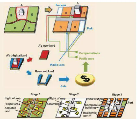
Although there is different terminology from one country to another including institutional and its legal framework, however urban development using land readjustment by converting property right by means of merging, sharing, relocating, exchanging, and modifying the size and shape of parcels based on the new layout plan and physical improvement together are essentially the same. During reconfiguration process, a portion of land will be reserved for sale to private developers to raise funds to finance a portion of the redevelopment costs, the benefits generated by the project are captured (Suzuki, et al., 2015). Land consolidation were extensively applied in Germany and Japan which afterward had been adopted by other European countries such as France, Netherlands, Finland, and Turkey as well as Asia-Pacific countries namely Australia, India, Indonesia, South Korea, Taiwan, and Hong Kong.