Article
http://ijfac.unsri.ac.id
DOI: 1024845/ijfac.v3.i3.94 94
Article Info
Received 23 September 2018 Receive in revised 29
September 2018
Accepted 30 September 2018 Available online 10 October 2018
Land Revegetation Post Clay Mine PT Semen Baturaja (Persero) Tbk in
OKU Selatan District "Challenges for Environmental Sustainability"
Marwan Sastradinata1,2*
1 Student of the Doctoral Program, Postgraduate in Environmental Management, Universitas Sriwijaya, Palembang 30139, South
Sumatra Province, Indonesia.
2Lecturer of PoliteknikAkamigas Palembang, Jl. Gubernur H.A. Bastari, Jakabaring, Palembang South Sumatera Province,
Indonesia
*Corresponding Author: [email protected]
Abstract
Clay as a non-renewable natural resource causes the number of reserves to be a limiting factor for mine age. The post-mining plan is prepared as an effort to restore the physical and environmental conditions that are disturbed by mining. Data collection was carried out with location surveys, literature studies, and institutional coordination. Mine reserves are known to be 36 million tons with a thickness of up to 25 m. The clay chemical composition consisted of SiO2 12.77-92.49%, Al2O3 2.95-27.64% and Fe2O3 0.53-29.46%. The environment disturbed by
post-mining will be managed with 39.5 ha of plantation designation, 13.5 ha of forestry and 1.7 ha of water treatment. Natural vegetation consists of secondary forests, shrubs, resident gardens. The diversity index value of the bush species of 2.940 is dominated by 15 plant species. Distribution of evenly distributed plants such as medang, aro wood, krinjing. Vegetation of cultivated plants is dominated by 10 types of plants such as coffee, pepper, rubber. Revegetation stage in the form of cover crop sowing, nurseries and the development of fast-growing plants. Post-mining revegetation uses plants that have suitable soil conditions so that environmental improvements and environmental sustainability of clay mines are achieved.
Keywords: Clay Reserves, Post-Mining Land, Revegetation, Environment
Abstrak (Indonesian)
Sumberdaya alam tak terbarukan seperti tanah liat, terbatas jumlah dan sebarannya sehingga kondisi cadangan menjadi faktor pembatas umur tambang. Rencana pasca tambang disusun sebagai upaya mengembalikan kondisi fisik dan lingkungan yang terganggu penambangan. Pengumpulan data dilakukan dengan survey lokasi, studi pustaka dan koordinasi instansional. Cadangan tertambang diketahui 36 juta ton dengan ketebalan mencapai 25 m. Komposisi kimia tanah liat terdiri SiO2
12,77-92,49%, Al2O3 2,95-27,64% dan Fe2O3 0,53-29,46%. Karakteristik tanah jenis
podzolik bertekstur lempung pasiran dan tingkat kesuburan alami rendah. Lingkungan terganggu pasca tambang 54,7 ha akan dikelola dengan peruntukan kebun 39,5 ha, kehutanan 13,5 ha dan water treatment 1,7 ha. Vegetasi alami terdiri hutan sekunder, semak belukar, kebun penduduk. Nilai indeks keanekaragaman jenis tumbuhan semak belukar 2,940 didominasi 15 jenis tumbuhan. Penyebaran jenis tumbuhan merata seperti medang, kayu aro, krinjing. Vegetasi tanaman budidaya didominasi 10 jenis tanaman seperti kopi, lada, karet. Revegetasi dilakukan untuk pemulihan vegetasi yang hilang akibat penambangan tanah liat. Revegetasi dilakukan secara bertahap dimulai dari penaburan cover crop, pembibitan dan pengembangan jenis tanaman cepat tumbuh. Revegetasi pasca tambang terhadap lahan tambang, fasilitas dan sarana penunjang tambang menggunakan tanaman yang memiliki kesesuaian kondisi tanah, akan memberikan dampak perbaikan kualitas lingkungan mencapai keberlanjutan lingkungan tambang tanah liat.
DOI: 1024845/ijfac.v3.i3.94 95 INTRODUCTION
The mining business license of clay production operations was obtained by PT Semen Baturaja (Persero) Tbk based on the Decree of the Regent of South OKU (Ogan Komering Ulu) number 303 / KPTS / DISTAMBEN / 2013 dated July 29, 2013 in the area of 1,228 ha in Datar village, Mehanggin village and Pendagan village in Muaradua District South OKU Regency, South Sumatra Province after completing exploration mining business license activities. Exploration results indicated 36 million tons of proven reserves of clay ready to mine in the area of 54.7 hectares with a production target of 180,000 tons/year to 20-year mine life, while the removal of land 450,000 BCM [1].
The initial hue is always affected by mining activities in mineral and coal resources. Restoring the function of the natural environment, social functions and restoring the function of forests as an ecosystem needs to be planned and systematic. Guarding and maintaining the preservation of natural resources is needed for human survival today, even for future generations [2]. Therefore, in accordance with the Republic of Indonesia Mineral and Coal Mining Law number 4 of 2009, the activity to restore the physical and environmental conditions of post-mining land revegetation are absolutely necessary. with the designation of the space for the South OKU Regional Spatial Plan year 2012-2032 [1]. The accomplishment of the mining business license location can be achieved through a mixed paved road from Palembang–Prabumulih–Baturaja–Martapura- Muaradua is approximately ± 270 Km or a trip for ± 6 hours using four-wheeled vehicles, but the width of the road between Muaradua–Simpang Martapura is still relatively narrow ± 4 m due to not being widened because the right side is bordered by the Komering river and on the left is bounded by hills. The location of the study is shown in Figure 1.
Methods
Reclamation and revegetation of post-mining land is an activity that must be carried out to recover and restore the function of the land and the designation of the environment. Quantitative observation methods by the direct survey to the field are verified by secondary
data and obtaining primary data as an effort to restore the environment.
Figure 1. Accessibility of Roads to Mining Business License Locations [1]
Descriptive analysis was carried out to illustrate how the baseline conditions were so that the technical aspects of post-mining land use could be mapped. Mapping in order to restore environmental functions is useful and sustainable. Primary data collection is carried out to obtain primary data by conducting direct observations, while secondary data to obtain secondary data through library research and institutional studies. RESULT AND DISCUSSION
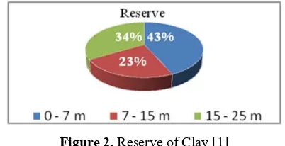
Clay as a non-renewable mineral resource is limited in quantity and distribution so it needs to be used optimally for the survival of the nation and state, on the other hand, the mining age is a limiting factor for the mine to end. The benefits of mining arising from mining business activities for the country are as a source of state revenue and foreign exchange earners. Another benefit is as a producer of raw materials for industry, construction of facilities and infrastructure, employment providers, labor absorption [3]. The amount of clay reserves at the study location is shown in Figure 2.
Figure 2. Reserve of Clay [1]
Geology and Morphology
DOI: 1024845/ijfac.v3.i3.94 96 65o but in some places, especially the foothills < 30o
[1].
Based on available deposits and technology characteristics, mine planning is carried out in an open mine with an open cut or open cast system ranging from 240 masl to 210 masl with mining stripping ratio SR <1 [1].
Clays are generally reddish, reddish brown, grayish brown to gray, soft and not layered, some contain fine sand to coarse sand, while the results of exploration drilling show clay thickness between 3 m to> 25 m with SiO2 important chemical constituents
between 12,77% - 92,49%, Al2O3 between 2,95% -
27,64% and Fe2O3 between 0,53% - 29,46% [1].
Initial hue
The initial hue or baseline environment of the mining business license location is a description of the state of the environment and the location of the planned activities, so it is important to study environmental measures as a result of a series of technical activities that have been and will be carried out primarily related
to the return of post-mining land functions. The initial baseline broadly covers the basics of physics - chemistry - biology - and economic - socio-cultural and public health. The location of mining business license and the surrounding land is mostly in the form of production forests that are not too dense, some of which are coffee, rubber, pepper and local agricultural plantations. The regional geological map of the study area is illustrated in Figure 3.
Figure3. Regional Geological Map of the Study Area [1] Muaradua and surrounding soil typesis shown inTable 1.
Table 1. Muaradua And Surrounding Soil Types [1].
No Soil Types Large Districts
Ha %
1 Reddish brown podzolic 30,178.21 6.874 Muaradua, Buay Sandang Aji, Tiga Dihaji, Buay Runjung, Pulau Beringin
2 Podsolic yellowish red 37,765.34 5.493 Muaradua, Buay Rawan, Buay Pemaca Total Area of Regency 549,394.00 100.00 19 districs
Land analysis results is shown in Table 2. Table 2. Land Analysis Results [1]
No Parameter Reeds Shrub CriteriaCoffee Garden *) Conclusions
I Soil Chemistry
1. pH H2O (1:1) 5.2 6.31 6.36 Acid
2. C-Organic (%) 0.12 0.7 0.19 Enough
3. N-Total (%) 1.25 1.87 1.50 Enough
4. P-Bray (ppm) 2.23 9.9 7.15 Less
5. K (me/100 gr) 0.16 0.14 0.17 Less
6. Na (me/100 gr) 0.31 0.29 0.36 Less
7. Ca (me/100 gr) 1.07 2.03 3.30 Very less
8. Mg (me/100 gr) 0.32 0.44 0.85 Very less
II Soil Texture
1. Sand (%) 52.5 55.24 60.49 Sandy sand
2. Dust (%) 30.05 28.75 18.03
3. Clayey (%) 17.35 16.0 29.51
*)Criteria: Soil Research Center and Agro-climate, 1983
According to data from South OKU District
DOI: 1024845/ijfac.v3.i3.94 97 reddish brown podzolic soil types and yellowish
podzolic associations that have low natural fertility or in general, soil reactions are classified as acid, low to moderate organic matter, low to moderate total nitrogen, very low-moderate P2O5 availability,
low-medium potassium (K <0.1 to 0.5 me / 100 g), low sodium (Na 0.4 - 0.7 me / 100g), calcium and magnesium are very low [1].
The texture of Muaradua soil is found to be formed from sediment, the upper part is clay and siltstone with an insertion of quartz silt, softer than the bottom which contains tufaan-brownish-reddish-white silt.
Natural Vegetation
Vegetation is a collection of plant populations consisting of many species with various forms, structures and populations that occupy habitats, formed from interactions between environmental factors such as soil, water, climate and genetics. Vegetation types consist of secondary forests, shrubs and gardens of coffee, rubber, pepper and mixtures. The function of vegetation as a protector of solar radiation and reduce extreme temperatures, maintain soil stability, prevent soil erosion and habitat for wildlife. Vegetation quality is assessed from species diversity, habitus and growth which show the environmental conditions in the ecosystem. The diversity of vegetation types illustrates the stability of a forest ecosystem that supports the life of wildlife habitat as a refuge, breed and source of food.
Reclamation or rehabilitation of degraded forest land activities is one of the five government policy priorities (Ministry of Forestry), and part of the agenda of the 21 Earth Summit in Rio de Janerio [5]. The activities of clay mining land clearing have resulted in forest areas not being vegetated. Returning forest economic benefits can be done by replanting the lost revegetation [6].
Forest areas in the study area include secondary forests, the constituent plants in the form of forest plants and shrubs are diverse, while the land around the settlement location has been disturbed by local residents for business plantation coffee, pepper and rubber. The community of secondary forest plants and shrubs consists of trees, shrubs and herbs. Tree species such as medang, leban, pelangas, bayur, krinjing and aro, while herbaceous plants such as weeds and grasses. Wildlife is a rare category and protected by Indonesian law, namely groups of mammals such as bears, tenok, deer, napu, deer, mouse deer, pangolins,
root tigers and clouded leopards; groups of birds such as eagles and partridge; and groups of reptiles such as cobras and estuarine crocodiles are found in secondary forests and shrubs. Other wild animals are found such as monkeys, long-tailed macaques and wild pigs.
The value of the plant species diversity index that composes shrub vegetation is 2,940. With the magnitude of the species diversity index <3.5 indicates the medium category [7]. While the important value index of plant species with individual distribution evenly is medang, aro wood and krinjing. Clay cover vegetation is shown in Figure 4.
Figure 4. Clay Cover Vegetation [1]
Important value index and diversity of shrub shrubs is shown in Table 3.
Cultivation Vegetation
Vegetation of plantation land is ± 80% coffee, ± 10% pepper and ± 10% rubber [1], while in the yard of the house, there are much vegetation producing fruit-producing crops such as durian, rambutan, duku, areca nut, coconut, banana and teak. Types of plants that are evenly distributed but few populations are mango, cempedak, jackfruit, breadfruit, noni, soursop, orange, roseapple, guava, papaya melinjo, jengkol, petai, kapok, embacang, sugar cane, ceremai, sweet potato, rubber, bogenvil and hibiscus.
Mine Age
Mine planning is intended to technically plan mining activities such as methods, systems, design, mine age, reclamation and post-mining. The mine design is designed with regard to technical criteria, among others:
DOI: 1024845/ijfac.v3.i3.94 98 Table 3. Important Value Index and Diversity of Shrub Shrubs [1].
No Plant Type Latin name KR (%) (%) KrR FR (%) NP (%) H’
1 Medang Actinodaphne sp 17.78 3.76 6.67 28.20 0.222
2 Kayu aro Ficus retusa 4.44 11.28 8.89 24.61 0.205
3 Krinjing Euptahorium odoratum 4.89 7.52 8.89 21.30 0.188
4 Pelangas Aporosa microcalix 14,66 1.01 4,45 20.52 0.090
5 Leban Vitex pubescens 13.33 2.51 4.44 20.28 0.182
7 Sepat Vatica maingyi 7.56 4.01 6.67 18.23 0.170
8 Simpur kubung Litsea sp 1.77 11.28 4.44 17.50 0.196
9 Balik angin Mallotus paniculatus 1.78 7.52 6.67 15.96 0.156
10 Seru Schima wallichii 0.89 8.77 4.44 14.11 0.144
11 Simpur Dillenia exelsa 2.22 5.01 6.67 13.90 0.142
12 Rose guava Eugenia sp 1.78 7.52 4.44 13.74 0.141
13 Keruing Dipterocarpus spp 2.66 6.26 4.44 13.38 0.144
14 Mahang Macaranga sp 7.56 4.01 2.22 13.38 0,156
15 Seduduk Melastoma malabathricum 4.44 3.76 4.44 12.65 0.133
16 Pulai Alstonia scholaris 2.67 1.50 4.44 8.61 0.102
17 Keliat Eugenia sp 3.11 0.50 4.44 8.06 0.097
18 Renghas Gluta renghas 0.44 3.76 2.22 6.43 0.082
19 Bungur Lagerstroemia speciosa 1.78 1.25 2.22 5.25 0.071
20 Terentang Campnosperma macropyhllum 0.44 2.51 2.22 5.17 0.070
Total 100.00 100.00 100.00 300.00 2.940
Diversity index 2.940
*) Remarks: KR: Relative Density, KrR: Relative Heap, FR: Relative Frequency.
The amount of land stripped for the first 3 years period is 80,000 BCM, 100,000 BCM for 5-10 years, 120,000 BCM for 10-15 years, and 150,000 BCM for 15-20 years.
Stages of the clay mining business license mining block shrubs is shown in Figure 5.
Figure 5. Stages of the Clay Mining Business License Mining Block [1]
Types of cultivation plantsis shown in Table 4.
Discussion
Reclamation is an activity to restore environmental functions so as to enable them to be reused as productive land, especially those related to land and air quality, prevention of erosion, degradation of water quality and pollution of heavy metals. Revegetation is done to restore the existence of disturbed plants due to an activity such as mining. Revegetation of ex-mining land uses different technologies and approaches in accordance with the conditions of ex-mining areas [8].
DOI: 1024845/ijfac.v3.i3.94 99 Table 4. Types of Cultivation Plants [1].
No Plant Types Latin Name Pendagan Village Location Datar Mehanggin *)
1 Coffee Coffea sp +++ +++ +++
The initial baseline of the mining business license clay study area of PT Semen Baturaja shows podzolic soil type and sandy clay soil texture with a low natural fertility level. The natural vegetation of shrub with the value of the uniformity index H '= 2.940 or medium category, dominated by 15 types of plants, among others, madang, aro wood, krinjing to seduduk. Cultivation of vegetation is dominated by 10 types of plants, in the form of a mixture of annual or seasonal plant species commonly found in mixed garden ecosystems originating from the opening of secondary forests. Annual plants play a role in the hydrological function, the enumeration of germplasm resources, microclimate effects, social, production, aesthetics etc. The success of revegetation, especially plants that have an important value of> 10% will provide a place to live a successful life of endemic animals.
Post-mining land covering an area of 54.7 ha will be managed with a pattern of allotment of a garden zone of 39.5 ha, a forest zone of 13.5 ha and a water treatment zone of 1.7 ha [1]. The arrangement and designation of garden land are carried out to restore the function and benefits of the garden as a regulator of water management, habitat protection, biodiversity (flora and fauna biodiversity), as well as a component of the garden ecosystem that produces environmental services. Revegetation is carried out in stages starting approximately 2 (two) years from the end of the post-mining period. The success of doing post-post-mining cannot only be seen from the final results, but judged to be achieved if various stages of rehabilitation activities are fulfilled, namely:
• Land management, this activity involves topsoil management and overburden, calculation of slope stability, prevention of erosion and sedimentation, final voids plan, etc.
• Revegetation, this activity involves sowing cover crops in a pile of soil or making holes in the soil
[10], improvement of soil quality, number of nurseries and the development of fast-growing pioneer plant populations and plant maintenance including fertilization. Furthermore, the selection of the types of plants to be planted in the ex-mining area depends on the local land conditions [9].
• Plant enrichment, this activity enriches the types of plants in the reclamation site with local plants or plants resistant to acid soil reactions [5]. • Plan for the use of the final voids that contain
water, this activity maintains water quality and the void design must be adjusted according to plan.
Environmental monitoring, this activity involves geotechnical monitoring, soil quality, erosion and sedimentation, water quality, acid mine drainage, successful revegetation, etc. Criteria for success of post-mining land activities is shown in Table 5.
The object of revegetation of post-clay mining activities in a total area of 55.15 ha is an indicator of the achievement of successful revegetation. Revegetation activities in conditions of land with low soil fertility are characterized by podzolic soil type with sandy clay texture, acidic reaction and moderate organic matter, requiring innovation to achieve optimal results.
Limestone distributed around Muaradua city and extends to almost west-east direction to Madura, Inner Land, Karang City and Simpang Saga South OKU was needed to increase the pH of soil and elements of N, P, Ca [12].
The action will increase the ability of the soil to store and provide nutrients becomes stable. Therefore, organizational development and community capacity as part of the criteria for successful land revegetation after clay mining can be synergized in the limestone processing opportunities for agricultural lime CaCO3
DOI: 1024845/ijfac.v3.i3.94 100 Table 5. Criteria for Success of Post-Mining Land Activities [1]
No. Post-mining Activity Activity Types Target Achievement Results Target Achievement Criteria
1. Ex-mining
land a. b. Demolition of mining facilities Reclamation of mining 1.5 ha .5 ha Completely dismantled facilities 1.5 ha 1.5 ha Completely dismantled and reclaimed c. Mine Road Reclamation 0.6 ha 0.6 ha Reclaimed entirely
d. Mine Road Maintenance 3.0 ha 3.0 ha Roads are suitable for use e. Surface Mining Reclamation
(waste dump) 48.8 ha 48.8 ha Reclaimed and revegetated entirely f. Reclamation of settling ponds 0.4 ha 0.4 ha Hoarded and reclaimed
entirely 2. Production
facility a. Demolition of production facilities 400 m
3 400 m3 Completely dismantled and
reclaimed b. Reclamation of ex-processing
facilities 1.0 ha 1.0 ha Reclaimed and revegetated entirely c. Recovery / remediation of soil
contaminated with chemicals, oil and B3
60 m3 60 m3 Under B3 quality standard
based on the results of soil analysis (TCLP test) 3. Supporting
facilities a. Demolition of workshop buildings (equipment, machinery, fuel tanks, explosives warehouses, and B3 TPS)
625 m3 625 m3 Completely dismantled and
reclaimed
b. Land reclamation of
ex-workshop area 0.5 ha 0.5 ha Reclaimed and revegetated entirely c. Handling the remaining fuel,
lubricants, chemicals 0.25 ha 0.25 ha Under B3 quality standard based on the results of soil analysis (TCLP test) d. Reclamation of former
transportation facilities 0.85 ha 0.85 ha Reclaimed and revegetated entirely e. Repair of office buildings and
Mess 1,150 m
3 1,150 m3 Worthy of use and livable
f. Reclamation of former
supporting facilities 1.5 ha 1.5 ha Reclaimed and revegetated entirely 4. Social,
cultural and economic development
a. Development of alternative
production businesses Village around mine
Village around
mine A new alternative business is formed according to local resources
b. Organizational development and village community capacity around the mine
Village around mine
Village around
mine Development of village business institutions, such as Village Owned Enterprise, Village Unit Cooperative 5. Maintenance a. Mine path 10.0 ha 10.0 ha Feasible to use
b. Plants 55.0 ha 55.0 ha Cover crops
The main forest plant is 625 trees / ha
DOI: 1024845/ijfac.v3.i3.94 101
No. Post-mining Activity Activity Types Target Achievement Results Target Achievement Criteria
6. Environ-mental inspection
a. Surface Water Content quarterly quarterly Quality standard of government regulations number 82, year 2001 b. Groundwater Content quarterly quarterly Minister of Health
regulations number 907, year 2000
c. Air Content quarterly quarterly Quality standard of government regulations number 41, year 1999 d. Noise quarterly quarterly Quality standard of
government regulations number 41, year 1999 e. Soil content yearly yearly soil chemistry, soil research
center, 1983
CONCLUSION
The success of land revegetation activities after clay mining will make the ecosystem function optimally so that it can function into a productive and sustainable area.
Post-mining land revegetation will gradually provide an impact on improving the environment and increasing the diversity of flora and fauna so that the environment of mining clay can be sustainable.
Characteristics and chemical elements of podzolic soil become obstacles to the achievement of post-clay mining revegetation activities. How to calcify and add soil organic matter can be an alternative to increase soil carrying capacity.
ACKNOWLEDGMENT
Thank you to Mrs. Prof. Dr. Ir. Siti Herlinda, M.Sc. who has given guidance on the Research Methodology course on the Doctoral Program, Postgraduate of Environmental Management at Sriwijaya University, Mrs. Dr. Ir. Restu Juniah, M.T., IPM. who have provided data correspondence, and PT Semen Baturaja (Persero) Tbk for the opportunity given to the survey team to conduct research.
REFERENCES
[1] PT Semen Baturaja, "Post-Mining Plan of Clay PT Semen Baturaja in South OKU District". Baturaja, 2017.
[2] R. Juniah, “Study of Carbon Value of the Allotment of Former Coal Mining Land of PT Samantaka Batubara for Sustainable Mining Environment,” J. Sustain. Dev., vol. 11, no. 4, pp. 213, 2018.
[3] R. Juniah, R. Dalimi, M. Suparmoko, S. S.
Moersidik, dan H. Waristian, “Environmental Value Losses as Impacts of Natural Resources Utilization of in Coal Open Mining,” MATEC Web Conf., vol. 101, pp. 4–8, 2017.
[4] S. Gafoer, T. . Amin, dan R. Pardede, Geology Map of Baturaja Sheet, Sumatra 1: 250,000 scale. Bandung: Center for Geological Research and Development, 1993.
[5] A. Pudjiharta, E. Santosa, dan M. Turjaman, “Reclamation Of Degraded Land With Revegetation In Former Cement Raw Material Mines,” Research Forests and Conservation. Natural, Vol. IV No, 2007.
[6] R. Juniah, “Environmental Management and Sustainability Sustainable Mining Environment : Technical Review of Post-mining Plans,” Indones. J. Env. Man. Sus. 1, no. September, pp. 6–10, 2017.
[7] A.Magurran, “Ecological Diversity and Its Measurement,” 1988.
[8] A. Dariah, A. Abdurachman, dan D. Subardja, “"Ex-Mining Land Reclamation for Expansion of Agricultural Areas ,” Journal of Land Resources,vol. 4, no. 1, pp. 1–12, 2010.
[9] R. . N. Setyowati, N. A. Amala, dan N. N. U. A. Aini, “Study of Revegetation Plant Selection for the Success of Ex-Mine Land Reclamation,” AL-ARD Journal of Environmental Engineering., vol. Vol.3 No.1, pp. 14–20, 2017.
DOI: 1024845/ijfac.v3.i3.94 102 1–4, 2015.
[11] M. Hamsah, “Reclamation Plan with Land Arrangement on Former Clay Mining Areas at PT. Holcim Indonesia Tbk, Cilacap, Central Java.”
![Table 2. Land Analysis Results [1]](https://thumb-ap.123doks.com/thumbv2/123dok/2712740.1675148/3.595.65.537.513.720/table-land-analysis-results.webp)
![Figure 4. Clay Cover Vegetation [1]](https://thumb-ap.123doks.com/thumbv2/123dok/2712740.1675148/4.595.314.536.252.413/figure-clay-cover-vegetation.webp)
![Figure 5. Stages of the Clay Mining Business License Mining Block [1]](https://thumb-ap.123doks.com/thumbv2/123dok/2712740.1675148/5.595.48.531.105.421/figure-stages-clay-mining-business-license-mining-block.webp)
![Table 4. Types of Cultivation Plants [1].](https://thumb-ap.123doks.com/thumbv2/123dok/2712740.1675148/6.595.69.528.114.238/table-types-cultivation-plants.webp)
![Table 5. Criteria for Success of Post-Mining Land Activities [1]](https://thumb-ap.123doks.com/thumbv2/123dok/2712740.1675148/7.595.48.559.97.754/table-criteria-success-post-mining-land-activities.webp)