A Participatory Evacuation ...(Hizbaron, et al)
A Participatory Evacuation Map Making Towards Sustainable Urban Heritage
Kotagede, Yogyakarta
Dyah R. Hizbaron
a,, Sudibyakto
a, Raditya Jati
b, Hidehiko Kanegae
c, Yusuke Toyoda
daFaculty of Geography, Universitas Gadjah Mada, Yogyakarta, INDONESIA bNational Disaster Management Agency, Jakarta, INDONESIA cCollege of Policy Science, Ritsumeiken University, Chiba, JAPAN dGlobal Innovation Research Organization, Ritsumeiken University, Chiba, JAPAN
Corresponding E-mail: [email protected]
Abstract
This research aims at development of Participatory Evacuation Map Making (PEMM) for Kotagede, Yogyakarta –
Indonesia. The research area is one of an important cultural heritage sites in Indonesia which is subjected towards earthquake hazard. The preliminary observation revealed that the area is a densely populated area, which characterized by dense wooden building structure, narrow street and minimum information of evacuation route which increase their vulnerability potentials. This leads to the idea of developing the PEMM to improve their awareness and preparedness during disaster events and creates sustainable condition for local livelihood security. The method develops within this research is actually a lesson learn from Ritsumeikan University, that has developed CSR for integration disaster management into heritage sites at Kyoto Prefecture. Their CSR covers several activities such as developing disaster information via vending machine and tourism map. Since Yogyakarta and Kyoto are engaged in “Sister City Development Program”, hereafter Universitas Gadjah Mada tries to do similar thing. Map making is an alternative prior to community experience in map making is rather frequent compare to vending machine habit. The preliminary finding of this research indicates that the
Kotagede community has been involved in several map making activity, such as “Green Map” and “Rehabilitation Sites Map”. However, they have not yet any experience to create any map which includes information such as evacuation route,
fire extinguisher, shelter information center and important meeting points. An improved critics from this research is to include meeting points level. As we all aware off, each meeting point have significant carrying capacity, thereby in the future a research on similar topics should add level and or category of meeting points. This is an important steppingstone for the research to conduct further research.
Keywords: participatory, evacuation, urban, heritage, Yogyakarta
Abstrak
Penelitian ini bertujuan untuk mengupayakan pembuatan peta evakuasi partisipatif untuk Kotagede, Yogyakarta – Indonesia.
Wilayah penelitian merupakan salah satu kawasan pusaka di Indonesia yang rawan terhadap ancaman gempa bumi. Hasil pengamatan lapangan yang dilakukan pada awal penelitian menunjukkan bahwa wilayah penelitian terdiri dari kawasan padat hunian, yang didominasi oleh bangunan berstruktur kayu, terletak di antara lorong yang sempit dan memiliki informasi yang minimum terhadap rute evakuasi sehingga meningkatkan potensi kerentanan masyarakatnya. Kondisi ini merujuk pada ide penelitian yaitu membuat suatu peta evakuasi partisipatif untuk meningkatkan kesiapsiagaan dan kewaspadaan saat kondisi krisis, dan mendukung kondisi yang berkelanjutan bagi penghidupan masyarakat. Metode yang digunakan
dalam penelitian ini merupakan salah satu pembelajaran “CSR” Universitas Ritsumeikan yang dikembangkan untuk diintegrasikan dalam penanggulangan bencana di kawasan pusaka Kota Kyoto. Metode “CSR” yang dikembangkan
memiliki beberapa jenis aktifitas seperti pengembangan sistem informasi kebencanaan melalui mesin penjual minum automatis dan peta wisata. Mengingat kota Yogyakarta dan Kyoto telah menjalin kerjasama program kota kembar, maka Universitas Gadjah Mada dalam hal ini mengadopsi metode yang sama. Penyusunan peta merupakan salah satu alternatif kegiatan berbasis komunitas yang lebih efektif dikembangkan di Indonesia di bandingkan pemanfaatan informasi dari mesin penjual minuman automatis. Hasil penelitian menunjukkan bahwa masyarakat Kotagede telah terlibat dalam kegiatan serupa sebelumnya untuk menyusun Peta Hijau dan Peta Kawasan Rehabilitasi. Namun, masyarakat Kotagede belum menghasilkan informasi evakuasi, lokasi pemadam kebakaran dan titik kumpul. Penelitian ini merekomendasikan penelitian selanjutnya untuk mengevaluasi sebaran titik kumpul. Sebagaimana diketahui, setiap titik kumpul memiliki daya dukung yang berbeda sehingga perlu untuk dianalisis lebih lanjut dalam penelitian berikutnya.
Introduction
Historically, Yogyakarta, Indonesia has experienced tremendous effects of natural disasters. Herein, Yogyakarta has played an important role in developing partnership geared to disaster risk reduction programs due to given geographic and geomorphologic setting which are prone towards several natural hazards, such as earthquake, landslide, volcanic eruption, flood, drought and tsunami. Kotagede contain the remains of the first capital of Mataram Sultanate, established in the 16thcentury. The remaining heritages are old palace, old royal cemetery, royal mosque, and defensive walls and moats. Indonesia has experienced “tourism booming” at the beginning of 1970s and it has brought positive influence for Kotagede. A number of old houses were developed as a craft showroom and restaurants for more cultural scenic. Ruins are preserved, together with its cultural activities. Home industry offers more than showroom, it also equips with workshop trip and courtesy of having direct lesson to do “silver crafting”, “handcraft batik” and many more. Today, Kotagede is still considered the site of origin with supernatural power being the focus of ancestral blessings and prosperity. During the May 2006 Java earthquake, many old buildings were destroyed and directly revitalized through Pusaka Jogja Bangkit! (“Yogyakarta Heritage Revival!”) program, carried out by Jogja Heritage Society, the Center for Heritage Conservation, Department of Architecture and Planning at Gajah Mada University, the Indonesian Network for Heritage Conservation, ICOMOS Indonesia, and other supporting institutions including the local community.
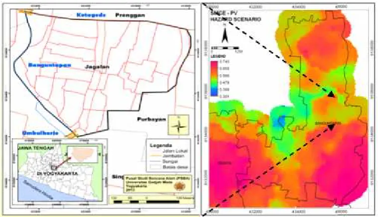
Administratively, the urban heritage is located among two sub districts (kecamatan) of Kotagede and Banguntapan, whereas Kotagede to Yogyakarta Municipality whilst Banguntapan have its place in Bantul Districts. Coincide among two administrative boundaries causes some overlapping in terms of disaster management program implementation. The research area is subjected as medium to high physically vulnerable area (Hizbaron, et al., 2012). The physical vulnerability term in here refers to settlement unit as element at risk (object observed) in vulnerability assessment. Thereby we can conclude that in terms of settlement characteristics, this area ismoderately vulnerable.
This research specifically observes effective evacuation mechanism within urban heritage sites in Kotagede, Yogyakarta area. The idea is to introduce “Corporate Social Responsibility” (CSR) for disaster management especially in urban heritage sites, as demonstrated by Ritsumeikan University in Kyoto Prefecture. The CSR covers several activities such as developing disaster information via vending machine and tourism map. An additional reference is a research carried out in Kyoto to assess disaster risk and road network improvement at historical city (Ahn et al., 2011), local perception towards disaster (Hardoyo, 2013; Sunarto and Marfai, 2012), fire hazard evacuation perception (Sagala et al., 2014) and local perception towards landslide hazard (Setiawan and Hizbaron, 2014).
Universitas Gadjah Mada has invested numerous activity programs to improve community based disaster risk reduction (CBDRR) in Kotagede area,
such as CBDRR for rehabilitation program of rumahjoglo (traditional house) as one of cultural heritage objects, CBDRR program to revitalize home industry (silver, puppet, tradition food, etc) as pivotal role towards local livelihood etc. Since Yogyakarta and Kyoto are engaged in “Sister City Development Program”, hereafter Universitas Gadjah Mada tries to do similar thing using participatory evacuation map mapping. Map making is an alternative prior to community experience in generating spatial information which is rather frequent compares to vending machine habit. The map making provides more applicable praxis to Kotagede, compares to vending machine utilization. The local habit is not into vending machine, and to add, Kotagede is not preferable provide information through vending machine since it should be accommodated with wider space, while the existing condition in the research area are mostly narrow alleys. Derived from previous data, the last 2006 earthquake occurrence had impacted 5,760 death tolls, 102,234 injured people, 2,020,788 refugees, 302,868 unit houses destructed (non habitable), 252,909 unit houses destructed (habitable) which traditional houses were also included. Based upon actual condition, there is increasing need towards better preparedness towards disaster occurrence either in Yogyakarta and Kotagede in specific. The preparedness includes any activity carried out within short period to disaster occurrence, i.e. evacuation modes (UNIDR, 2005).
Tourism is definitely sector at risk during disaster. Tourism activities in urban heritage site attracts tourist, whom have limited spatial information about the area. Thereby,an additional spatial information during
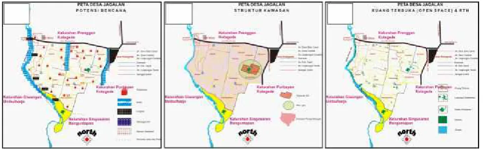
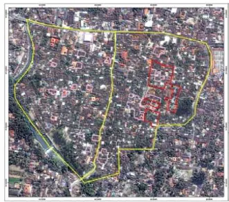
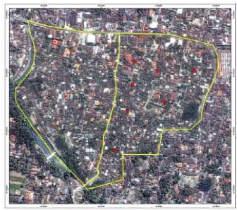
emergency situation would be perfect for local support. Urban heritage offers social cultural scenic, via architecture characteristics, local livelihood, social setting etc. In some cases, urban heritage located in hazardous area andit congruent to volatile built up environmental setting (Cioccio & Michael, 2007). This is definetly the case of Kotagede, which exposes to seismic activities and its collateral hazard, such as fire. As for this case, not much publication can be reffered, except those given by case study of fire in Bandung settlements (Sagala et al., 2014). This surely put some of the built up environment i.e. cultural heritage site, infrastructure network, low-medium scale home industry of silver, leather and traditional food stalls as element at risks.The previous research has revealed that Kotagede poses medium to high physical vulnerability (Hizbaron, et al., 2012). Figure 1 demonstrates darker shades as area with higher physical vulnerability (observed objects were buildings). In fact, without hazard potential, the remaining heritage objects, such as traditional houses, museum, art-work, ancient mosque, and ancient palace are already in critical condition due to threatening ages. Accordingly, these critically valuable objects are facing normal threat (age or time) and sudden threat from natural hazard. These valuable objects are located among narrow street, surrounded by high concrete wall and constructed from wooden-concrete material (Figure 2). These ancient buildings are compacted together with dense settlement unit, thereby, it can not be modified easily. Any built up environment modification possibly relates to direct social economic change. This research believes that Kotagede is not merely physically vulnerable, but also socially and economically vulnerable.
b. a.
c. d.
Tourists are welcomed to stroll down narrow streets and to document its unique architectural setting. This touristic attraction is similar to those offered in Venice, Italy, whereas tourist predominantly walk along narrow streets and socially involves within rapid dwelling system. Consequently, during emergency situation there will beslow evacuation modes, which increase severity of local dwellers and tourists to survive from any disaster occurrences.
Hereafter, the built up environment along Kotagede area provides a very interesting case study for evacuation mechanism. A growing intension towards disaster management especially during crisis or emergency phase into tourism industry is followed with limited contribution of theoretical construction (Ritchie, 2004; European Parliament, 2007). Thereby, this research adopts fundamental theory of CSR and CBDRR to be implemented in the research area.The basic idea on evacuation mechanism should considers local perception towards information, visualization, communication, and participation methods. Previous research has indicated that community mapping is a strong points for Kotagede, since local stakeholder have very good kinship, culturally bounded and strongly engaged within economic activities.
Research Method
Research into urban heritage protection has mainly focused on preservation and protection towards classic periodic threat. However, few studies have given attention to other possible threat, such as sudden natural threat and more specifically to colliding social interest within the urban heritage sites. In most cases, these different threats entitled for different management system. Leitmann (2007) has analyzed
post disaster response in Indonesia using two cases from major scale disaster occurred in Aceh last 2004 and medium scale disaster occurred in Yogyakarta last 2006 and found that Indonesia should initiatively incorporates pre-disaster action i.e. prevention and preparadness and not just highlight post disaster action i.e. rehabilitation and reconstruction. The prevention and preparedness includes 1) an accurate analysis of hazard and vulnerability population; 2) formulation of disaster preparedness and response plan and 3) communicating prevention and preparedness to public and key decision makers (Leitmann, 2007). A study by Mileti & Gailus (2005) add that pre-disaster plan or mitigation plan supposes to embed within social value as collective design also highlight that the mechanism should not merely rely upon technical or structural design (Mileti & Gailus, 2005). The idea is actually in line with previous studies by Pearce (2003; 2005) and O’Brien et al. (2010) which put highlight to strengthen social learning for effective prevention, preparedness and mitigation process (Pearce, 2003; Pearce, 2005; O’Brien et al., 2010). Thus, this study focuses on identification possible prevention and preparedness mechanism within prone urban heritage sites using collective design which involves local community to identify their evacuation route. A participative process applied in this research combined with spatial and temporal approach using Participatory Geographic Information System.
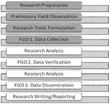
The research employs quantitative and qualitative method to attain objectives (Figure 3). The research initially plan three sessions of forum group discussion to collect data, verify data and disseminate data.
Goal 1. Identify community perception towards disaster preparedness in research area. As this research aims to reveal community perception towards disaster preparedness, thus the research try to explore from any information, visualization, communication and participation related to hazard, vulnerability and risk. Hereafter, derived from these guidelines, the research analyzes which activities considers as preparedness.
The research invites representatives in two villages
(
dusun
Bodon and
dusun
Sayangan), at Desa
Jagalan, Kelurahan Jagalan, Kecamatan
Bangun-tapan, Bantul – Yogyakarta, as the target group for
participative process. In early stages – FGD 1 – the
research collects participative understanding towards
existing potential hazard, vulnerable groups and
evacuation routes using map as a media for them to
draw (Participatory Geographic Information
System). The participatory results provides input for
FGD 2 to verify. As FGD 3 involves participants
from FGD 1 & 2, and the main objective of FGD 3
is to disseminate research result to all participants.
Further analysis highlights which among information, visualization, communication and participation that have dominant preference in the community. The expected result is community based disaster preparedness profile in the research area.
Goal 2. Mapping evacuation route for preparedness in the research area.Forum group discussion (FGD) involves several key person and local stakeholder. In order to attain second objective, this research provides several copies of thematic map with high resolution images, and explore target group to identify these following indicators, i.e. location, street width, wall height, infrastructure, route, impacted building, impacted group and temporary shelter. The research also prepare thematic map based upon high resolution image to help participatory mapping activity.
This unit of analysis of the research is hamlet or Desa. Desa Jagalan consists of two smaller administrative units called dusun, namely dusun Sayangan (12.8 Ha) dan dusun Bodon 13.9 Ha). DesaJagalan is located within Sub District Banguntapan, Bantul District – neighboring Sub District Kotagede, Yogyakarta City. Additionally,Desa Jagalan also poses a very strong urbanized characteristics. High resolution satelite imagery has indicated that nearly 83% out of total area within
two dusun are predominantly for dwelling units (settlement), 4.5% are heritage sites, and 12.6% are open space for seasonal garden. Given such dense built up environment, the research area provides very unique architectural setting which then specify their strategy to accommodate disaster occurences.
Demographic setting in the research area indicates that children and elderly are predominant group, which increases their vulnerability potential. Population density within this area is approaching 130 lives/km2, whereas their occupation are predominantly in services and home industries (steel, puppet, silver and traditional food). This sector were also collapsed during last 2006 earthquake, which then improved using small scale entrepreneur financial supports.
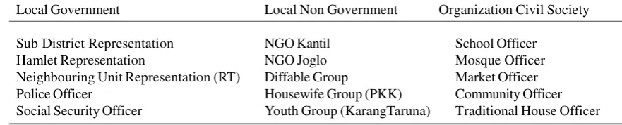
Given with such large demographic setting, this research design series FGDs with targeted participant. The participant has invited of more than 40 respondents representing following social structure (Table 2).
During FGDs, each respondentsis divided into two groups to represent geographical area,dusunBodon and dusun Sayangan. To ensure research consistency, the following series of FGD also involves the same participant. Participant have to verify preliminary research finding during second round FGD. The research also designs to add more information during second round of FGD by inviting more participant from local board of disaster management, local tourism agency and local heritage site protection and preservation agency.
Local Government Local Non Government Organization Civil Society
Sub District Representation NGO Kantil School Officer
Hamlet Representation NGO Joglo Mosque Officer
Neighbouring Unit Representation (RT) Diffable Group Market Officer Police Officer Housewife Group (PKK) Community Officer Social Security Officer Youth Group (KarangTaruna) Traditional House Officer
Table 2. Focus Group Discussion Participant
Table 1. Demographic Setting Research Area
No Age Sayangan Bodon Total
Results and Discussion
The preliminary observation has revealed that the research area has several strong points. First, local community have carried out similar activity – partici-patory mapping – via Green Mapping Activity and Community Settlement Plan (CSP) conducted by Local Government of Bantul and Rekompak – Jogja Reconstruction Fund.
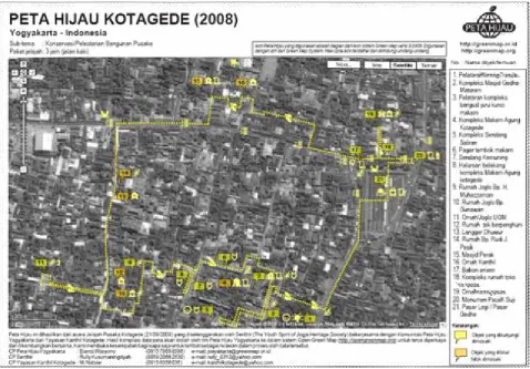
Figure 4. Green map Kotagede (Figure not to scale). This figure is a participatory map resulted from previous activity program entitled JelajahPusakaKotagede, organized by The Youth Sprint of Jogja Heritage Society in collaboration with Green Map Community Yogyakarta and Kanthil Yogyakarta. The information depicted within this map is identification towards several tourism destinations surrounding Kotagede. There are proximately 21 tourism destinations within this area which has specific icon.
First, derived from the experience of “Green Map-ping Activity”, local stakeholder have experienced in determining heritage sites in their area (Figure 4). This simplifies the argument that “the more the merrier”, the more experience they have in partici-patory mapping activities, the merrier it would be. The idea to visualize information is very clear for them.
No Disaster Location Period Impacted (household)
1 Flood Bodon (RW 4/RT 6, 9, 10, 11) 1 year 54 Households 2 Earthquake All 50 year 1,024 Households
3 Fire All - 1,024 Households
4 Inundation Bodon RT 1Sayangan (RT 6, RT 8) 1 year 30 Households 5 Landslide Bodon RW 5/ RT 9, RT 10, RT 11 1 year 21 Households
a
.
c.
b
.
Figure 5. Participatory mapping in the research area. (a) Participatory mapping for hazard probability. Kotagede area has several hazard potential as noted within this map, i.e. fire, flood, landlside, and disease outbreak. Among three sub district, Umbulharjo, Banguntapan and Kotagede suffers the most frequent hazard from fire and flood. This participatory mapping is not indicating any potential earthquake hazard yet. (b) Participatory mapping for heritage sites. The structure of the area is divided into three zones, such as core zone (light orange), buffer zone (light green), and cultivation/developing zone (light red). The core zone and buffer zone is located in Sub District Kotagede, Yogyakarta, while cultivation/developing zone is located in Sub District Banguntapan, Bantul. (c) Participatory mapping for green space.Some indication for meeting point for evacuation has been carried out by this map. (Figure is not yet to scale).
Second, CSP Programe also made it possible for the local community to experience participatory mapping in determining heritage zonation and open green space area (Figure 5). The community understand very well how to read legend and how to use the map. As depicted in figure 5 that the blue lines cated potential area inundated by flood, red dot indi-cates fire potential, while black lines indicated land-slide potential and red lines indicated dengue fever potential. Additionaly, they had also make sort of participatory database to indicate disaster risk po-tential (Table 3). The main idea to get commitment from community during planning process also not a brand new concept for them. Their experience surely adds stronger hypothesis that the community are willing to be involved during information process and to be committed during information dissemination. An interesting point from the previous work is that they also learn that hazard potential involves period or time span and impact level.
As the research area had equipped with hazard and risk information, thus FGD1 highlighted on
Figure 6. Vulnerable Group in Kotagede Area (Figure not to scale). The forum group discussion able to identify a very usefull information about whom are vulnerable groups in their surrounding, i.e.diffable group (red), physichological trauma (blue), elderly (green) and paralyzed group (brown). They are fully aware of their existence, thereby this houses is indicated as vulnerable element.
Unfortunately, the existing fire extinguisher have not yet adequate to cover whole research area. Partici-pants from dusun Sayangan have more access to fire extinguisher, whilst participants from dusun Bodon have no information about fire extinguisher. This off course, triggers more challenge in the future to deal with fire hazard in bothdusun. Based upon previous evacuation experiences and actual street condition (street width, wall height, and accessibil-ity), participant also able to determine effective evacuation route for their area (Figure 8). There are two possible evacuation routes, through northern route or southern route. Northern route provide more ac-cess to open spaces, while southern route provides smaller space to move onwards since it ended throught riverbank. Unfortunately, the research area has not yet provide any mitigation or preparedness signs within tourism destinations sites. In fact, this revealing finding exhibit that the research area yet promote sustainable urban heritage, however local stakeholder awareness has somehow highlights their potential social and cultural capital which ensures their future security towards any sudden disturbance such as disaster.
Lets take a look at Kyoto, as a sister city of Yogyakarta through “Sister City Development Program” – a form
of twin towns or sister cities with cooperative agreements between towns, cities, and even counties within geographically and politically distinct areas to promote cultural and commercial ties. The concept of twinning was originally intended to foster friendship and understanding between different cultures and between former foes, as an act of peace and reconciliation, and to encourage tourism. Included within the concept is a platform for cities and regions from all over the world to exchange experiences and know-how to assist them in applying more and better-targeted cooperation. Kyoto Prefecture has been hosting a wood conservation-training program for its sister city Yogyakarta, Indonesia since 1999. Meanwhile the cooperation between Kyoto and Yogyakarta as sister cities has been lasted since 1985, and the two cities have also cooperated in restoring the Yogyakarta Royal Palace (Kraton) located near the UNESCO World Heritage Site of Borobudur. The Indonesian authorities reached out to its sister city Kyoto for aid in conserving the wooden Royal Palace. Derived from this concern, joint university to university learning program, both parties agreed to focus upon existence of wooden house – as part of conserved traditional houses – which likely prone to earthquake and fire hazard.
Hereafter, Kotagede indicates slightly different experience from Kyoto. Kyoto experiences very structured planning towards local preparedness strategy (Ahn, Tsukaguchi, Ogawa, & Tanaka, 2011). Local signs has been established and followed with local participation. Kotagede have established CBDRR through many CSR activities – provided by NGOs (Non Government Organization), academics, media, etc.
As argued earlier, the existence of traditional houses, and other heritage sites are particularly exclusive apart from any community action. The research area presents explicit example, that tourist activities are somewhat yet highlighted within any CBDRR action. Participatory map making generally targeted local community as end user, without emphasizing to potential tourist as map user as well. Community board, religious meeting, and or street sign provide information merely to local community. There are only few information to tourists related with map and traditional house description which exbihit along main street.
Kyoto in the other hand, presents quite similar stories in terms of dwelling characteristics. Its rapid neighbourhood area, which predominantly made by bricks, wood and constructed using traditional structures shares similar vulnerability level with Yogyakarta. However, their participatory map making
is somewhat integrated within local government initiatives, which then involved active participation from local community. Currently, Kyoto has exhibited numerous mapping scale unit, down into very detail scale. Meanwhile, Yogyakarta has just initiated to use high satellite imagery for detailed use, but not to consider very detail building characteristics as in Kyoto. Henceforth, further research challenge for Yogyakarta is to delineate detailed evacuation mechanism using very sensitive building characteristics. The availability of local knowledge to inform, to visualize, to communicate and to participate within such detailed scope make possible to increase better and sustainable urban heritage protection. An addition point for further research is to combine disaster risk information for tourist guide.
In summary, the know-how technology of CSR and CBDRM praxis in Kyoto and Yogyakarta, arguably influenced by different stakeholder, geographic characteristic and infrastructure availability in both areas. Yogyakarta has not yet establish its integration between local dweller and tourist in terms of information dissemination. For further research, it is important to allocate integrative information that can be use both by local dweller and tourist at once. This research recommends evaluation and monitoring towards CSR activities regularly, therefore the sustainability of the program is assured.
Figure 9. Evacuation routes at research area, comprises from two routes, northern route and southern route (Figure not to scale).
Southern Route
Acknowledgements
The authors would like to acknowledge Directorate General of Higher Education (DGHE) Indonesia, Secretariate Bureau of Administrative Yogyakarta, Local Disaster Management Board (BPBD)
References
Ahn, Y., Tsukaguchi, H., Ogawa, K., & Tanaka, K. (2011). Study on Disaster Risk Assessment of Cultural Heritage and Road Network Improvement in Historical City. Journal of Disaster Research , 6 (1).
Cioccio, L., & Michael, E. J. (2007). Hazard or Disaster: Tourism management for the inevitable in Northeast Victoria. Tourism Management, 28, 1-11.
European Parliament. (2007). Protecting the cultural heritage from Natural Disasters. Policy Department Structural dan Cohesion Policies - Culture and Education, Directorate General Internal Policies of the Union. European Parliament.
Hardoyo, S. R. (2013). Pendekatan Sosio-Ekologi dan Teknologi SIG dalam Pengurangan Risiko Bencana (Kajian Multi Disiplin dalam Analisis Bencana Banjir di Pesisir Pekalongan). Seminar Nasional Pendayagunaan Geospatial Untuk Optimalisasi Otonomi Daerah. Surakarta: Fakultas Geografi UMS & Indonesian Geographical Society (IGI)
Hizbaron, D. R. (2012). Dissertation: Integration of Vulnerability Assessment towards Seismic Based Spatial Plan in Bantul, Yogyakarta, Indonesia. Yogyakarta: Universitas Gadjah Mada.
Hizbaron, D. R (2011). Urban Risk Management: An Overview from Geographical Studies. International Conference on the Future of Urban and Peri Urban Area (pp. 84-96). Yogyakarta: Environmental Geography Department Faculty of Geography Gadjah Mada University ISBN: 978-979-3969-43-5.
Leitmann, J. (2007). Cities and Calamities: Learning from Post-Disaster Response in Indonesia. Journal of Urban Health: Bulletin of the New York Academy of Medicine, Vol. 84 No 1 Doi: 10.1007/s11524-007-9182-6 , 144-153.
Local Government Sub District Banguntapan. (2008). Community Settlement Plan (CSP) Desa Jagalan, Kecamatan Banguntapan, Kabupaten Bantul Daerah Istimewa Yogyakarta. Bantul: Local Government of Sub District Banguntapan.
Mileti, D. S., & Gailus, J. L. (2005). Sustainable Development and Hazards Mitigation in the United States: Disaster by Design Revisited. Mitigation and Adaptation Strategy for Global Change Vol. 10 , 491 - 504.
Pearce, L. (2003). Disaster Management and Community Planning, and Public Participation: How to Achieve Sustainable Hazard Mitigation. Natural Hazards (28) , 211 - 228.
Pearce, L. (2005). The Value of Public Participation during A Hazard, Impact, Risk and Vulnerability Analysis. Mitigation and Adaptation Strategy for Global Change 10 , 411 - 441.
O’Brien, G., O’Keefe, P., Gadema, Z., & Swords, J. (2010). Approaching disaster management through social learning. Disaster Prevention and Management Vol 19 NO 4 DOI 10.1108/09653561011070402 , 498-508.
Ritchie, B. W. (2004). Chaos, crises and disasters: A Strategic Approach to Crisis Management in the Tourism Industry. Tourism Management, 25, 669-683.
Sagala, S., Wimbardana, R., & Pratama, F. P. (2014). Perilaku dan Kesiapsiagaan terkait Kebakaran pada Penghuni Permukiman Padat Kota Bandung. Forum Geografi, 28 (1).
Setiawan, H., & Hizbaron, D. R. (2014). Study of Local People Perception related to landslide hazard: A Case of Tawangmangu Sub District Karanganyar Regency Indonesia. Forum Geografi, 28 (1).
Sunarto, & Marfai, M. A. (2012). Potensi Bencana Tsunami dan Kesiapsiagaan Masyarakat Menghadapi Studi Kasus Desa Sumberagung, Banyuwangi Jawa Timur. Forum Geografi, 26 (1).