15
Lilik Budi Prasetyo
1. Case study 1: Balairaja Wildlife Reserves Case
1.1. History of the reserve encroachment
Balairaja Wildlife reserves area is one of a number of natural reserves in Riau Province which was established under the Minister of Forestry Decree No. 173/Kpts-II/1986 on 6 June 1986 covering areas of 18,000 hectares. Changes on land use occurred in Balairaja Wildlife reserves are not separated from government’s policies in economic, social and cultural aspects. For Balairaja Wildlife reserves case, the existence of forest concession rights, plantation and Caltex’s mining business.
Oil exploration in Riau which dated back in 1924 was under the administration of Standard Oil Company of California (Socal). In 1936 the holding company became part of Caltex (merger of the Texas and Socal). Five years later, the company drilled into the formation that would become the Duri Field (Chevron Texaco, 2005a). In 1944 a well near Minas village was drilled by Japanese troops. Minas became the largest oil field ever discovered in Southeast Asia. Interrupted by the war and Indonesia’s subsequent struggle for independence, production began in 1952. In 1963, the company was incorporated in Indonesia as PT Caltex Pacific Indonesia (CPI)(Chevron Texaco, 2005b). When access to forest areas is possible, the Sakai tribe in 1964 started to go into forest areas which is now becoming Farmer Village Pinggir sub-district. They employed swidden cultivation, primarily for food crops. This forest was then claimed by Sakai Tribe as their traditional forest. In 1970, Social Department employed a program called Isolated Tribe Resettlement
(Program Pemukiman Kembali Masyarakat Terasing – PKMT) in Pematang Pudu Village, Mandau Sub-district. This program provided permanent houses for the Sakai community.
After the implementation of the investment policy both national and foreign, in 1977, 1978 and 1980, in this area the government issued Forest Concession Rights to 3 concession companies. This effort has given access to the people to step into forest and the economic activities grow and at some points its brought more and more people to enter into the Balairaja Forest area. A community leader revealed that in 1982 the Javanese and Bataks started enter the Balairaja area. They started to do permanent agriculture and grow rubber plants. Due to the success of this rubber plantation, this technique is then imitated by Sakai Community which has previously no knowledge of rubber plantation.
households of Java ethnic went into Petani Village of Mandau Sub-district and cutting down the forest of Balairaja Wildlife reserves and grow oil palm in the area. This oil palm plantation became larger and larger because of the law was not working optimally. The peak of the looting of Balairaja Wildlife reserves areas was in 1997 when economic crisis hit Indonesia and the succession of Suharto regime was going on in 1998. Table 15.1 describes the chronology of some important events.
1.2. Trend of Land Use Changes
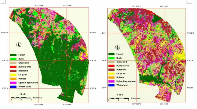
Spatial distribution of land-use and land cover in 1985, 1989, 1992, 2000 and 2004 is presented in Figure 15.1, Figure 15.2, Figure 15.3, Figure15.4 and Figure 15.5.
Fig . 1 5 .2 .
Fig . 1 5 .3 .
Fig . 1 5 .5 .
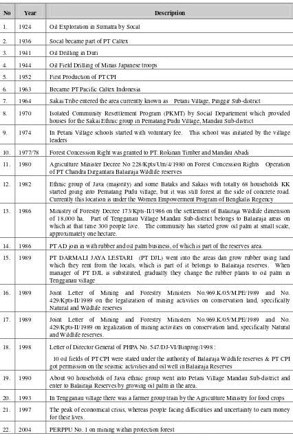
Table 15.1. Summary of the History of Policy and Its Implication to Balairaja Wildlife reserves
No Year Description
1. 1924 Oil Exploration in Sumatra by Socal
2. 1936 Socal became part of PT Caltex
3. 1941 Oil Drilling in Duri
4. 1944 Oil Field Drilling of Minas Japanese troops
5. 1952 First Production of PT CPI
6. 1963 Became PT Pacific Caltex Indonesia
7. 1964 Sakai Tribe entered the area currently known as Petani Village, Pinggir Sub-district
8. 1970 Isolated Community Resettlement Program (PKMT) by Social Departement which provided
houses for the Sakai Ethnic group in Pematang Pudu Village, Mandau Sub-district
9. 1974 In Petani Village schools started with voluntary fee. This school was initiated by the village
leaders
10. 1977/78 Forest Concession Right was granted to PT. Rokinan Timber and Mandau Abadi
11. 1980 Agriculture Minister Decree No 228/Kpts/Um/4/1980 on Forest Concession Rights Operation
of PT Chandra Dirgantara Balairaja Wildlife reserves
12. 1982 Ethnic group of Java (majority) and some Bataks and Sakais with totally 68 households KK
started going into Pematang Pudu village, but it was still forest at the side of concrete road. Currently this location is under the Women Empowerment Program of Bengkalis Regency
13. 1986 Ministry of Forestry Decree 173/Kpts-II/1986 on the settlement of Balairaja Wildlife dimension
of 18,000 ha. Part of Tengganau Village Mandau Sub-district belongs to Balairaja areas on which at that time 300 people live. The community has started grow oil palm at small scale, approximately one hectare.
14. 1986 PT AD join in with rubber and oil palm business, of which is part of the reserves area.
15. 1989 PT DARMALI JAYA LESTARI (PT DJL) went into the areas dan grow rubber using land
which they rent from the locals, which is part of it belongs to Balairaja reserves. When manager of PT DJL is substituted, gradually they change the rubber plants to oil palm in Tengganau village
16. 1989 Joint Letter of Mining and Forestry Ministers No.969.K/05/M.PE/1989 and No.
429/Kpts-II/1989 on the legalization of mining activities on conservation land, specifically Natural and Wildlife reserves
17. 1989 Joint Letter of Mining and Forestry Ministers No.969.K/05/M.PE/1989 and No.
429/Kpts-II/1989 on legalization of mining activities on conservation land, specifically Natural and Wildlife reserves.
18. 1998 Letter of Director General of PHPA No. 547/DJ-VI/Binprog/1998 :
10 oil fields of PT CPI were stated under the authority of Balairaja Wildlife reserves & PT CPI got permission on the seismic activities and oil well in Balairaja Reserves
19. 1990 About 90 households of Java ethnic group went into Petani Village Mandau Sub-district and
enter to Balairaja Reserves by growing oil palm in the area.
20. 1993 In Tengganau village there was a farmer group train by the Agriculture Ministry for food crops
21. 1997 The peak of economical crisis, whereas people facing difficulties and uncertainty to earn money
for their lives.
-2000.00
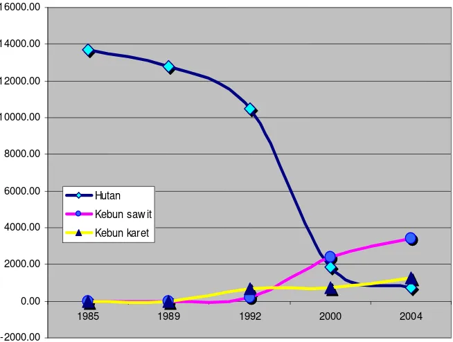
F igure. 15.6. Graphic of Changes on Forest, Oil Palm and Rubber Plantation
In the period of 1985 to 1989 forest conversion is mostly to fulfil wood needs. This can be seen fro the dimension of land which is not taken care of in the form of bushes, weed, and open land compared to the dimension of land use as cultivation areas (Table 15.2).
Table 15.2. Changes of Land Use for 1985 – 1989 Period (in Ha)
Forest 12,808.48 0.00 0.00 0.00 0.00 0.00 0.00
Bushes 333.23 641.47 51.11 0.00 18.29 0.00 0.45
Grass 437.49 429.04 669.80 5.53 56.31 0.04 0.63
Bare land 72.87 5.54 30.27 236.84 735.07 0.05 2.16
Swidden Cultivation 3.43 1.54 4.17 8.88 4.35 0.43 0.00
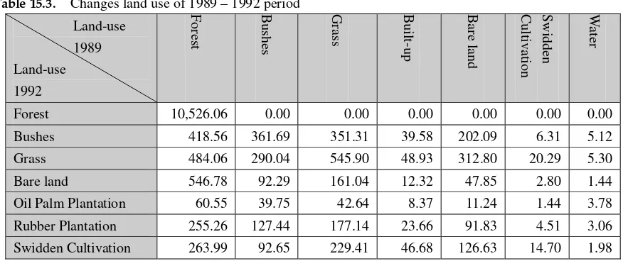
Table 15.3. Changes land use of 1989 – 1992 period
Bushes 418.56 361.69 351.31 39.58 202.09 6.31 5.12
Grass 484.06 290.04 545.90 48.93 312.80 20.29 5.30
Bare land 546.78 92.29 161.04 12.32 47.85 2.80 1.44
Oil Palm Plantation 60.55 39.75 42.64 8.37 11.24 1.44 3.78 Rubber Plantation 255.26 127.44 177.14 23.66 91.83 4.51 3.06 Swidden Cultivation 263.99 92.65 229.41 46.68 126.63 14.70 1.98
In 2000 – 2004 period conversion of land becoming oil palm and rubber plantation is still going on, but with a very slow pace. In this period the pace of the conversion of bushes and grass becoming plantation is faster than that of forest conversion becoming plantation. This is an indication that the existing forest is becoming more and more difficult to be converted to become plantation (Table 15.4)
There is something that needs a careful consideration from the above table; part of the oil palm plantation is again becoming bushes/grass. There are some possible explanations, they are: first, the converted land is not just right to grow oil palm so that the crops failed and the land is left, second: the plantation they have built is damaged by wild animals or fire besides the fact the land is actually not suitable for such type of plantation.
Bushes 262.77 202.55 74.56 4.83 13.98 67.33 17.96 46.23 2.25
Grass 179.23 369.38 614.71 14.22 82.08 229.63 53.69 170.05 1.53 Bareland 249.09 305.44 700.90 134.37 2622.49 228.64 85.72 604.41 16.83 Oil Palm Plantation 187.61 489.14 576.30 27.80 255.07 1245.75 201.75 404.08 2.97 Rubber Plantation 105.69 151.32 205.11 9.48 148.82 236.32 192.82 212.31 2.07 Swidden Cultivation 68.60 197.68 350.90 46.40 452.51 294.61 140.85 1275.87 4.32
2. Case study 2 : Cikepuh Wildlife Reserve
2.1. History of Reserve encroachment
Cikepuh wildlife reserve area is one of a number of natural reserves in West Java Province which was established under the Minister of Forestry Decree No.523/Kpts/Um/10/1973 on April 1973, covering areas of 8127.5 Ha. Part of the reserve area was an oil palm plantation which was developed in 1911. After a while, in 1921, the Dutch government announced the area was designated as protected forest, after having an agreement with the oil palm plantation administration.
Before the establishment the area as wildlife reserve, some people have been settled within the area. It was reported that in 1970, some people converted the reserve into agricultural land and settlement. Most of them are still staying within the reserve till now.
Even though the area was established in 1973, the border gazetment just started in 1985. In 1986 illegal forest conversion of about 42.5 ha was also reported. During the el-Nino in 1998, forest fire also occurred, however, the magnitude of the forest fire was not reported. In 1999, a huge forest encroachment coordinated by an NGO occured in the reserve (Pikiran Rakyat. 2002)
After Regional autonomy, the reserve encroachment have been continuing, even with greater scale. It was reported that the encroachment was coordinated by an NGO. Thousands of people were entered to the area. Based on the interview and reports, the people who are entered into the Reserve originated from other District area, which are far from Cikepuh Wildlife reserve, such as Garut, Cianjur, and Tasikmalaya (Figure. 15.7). Summary of the history of reserve encroachment is presented in Table 15.5.
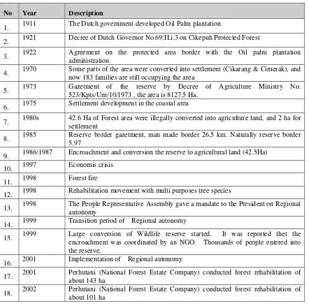
Table 15.5. Summary of the History of Policy and Its Implication to Cikepuh Reserve
No Year Description
1. 1911 The Dutch government developed Oil Palm plantation
2. 1921 Decree of Dutch Governor No.69;II.i.3 on Cikepuh Protected Forest
3. 1922 Agreement on the protected area border with the Oil palm plantation administration
4. 1970 Some parts of the area were converted into settlement (Cikarang & Cimerak), and now 183 families are still occupying the area
5. 1973 Gazetment of the reserve by Decree of Agriculture Ministry No. 523/Kpts/Um/10/1973 , the area is 8127.5 Ha.
6. 1975 Settlement development in the coastal area
7. 1980s 42.6 Ha of Forest area were illegally converted into agriculture land, and 2 ha for settlement
8. 1985 Reserve border gazetment, man made border 26.5 km. Naturally reserve border 5.97
9. 1986/1987 Encroachment and conversion the reserve to agricultural land (42.5Ha)
10. 1997 Economis crisis
11. 1998 Forest fire
12. 1998 Rehabilitation movement with multi purposes tree species
13. 1998 The People Representative Assembly gave a mandate to the President on Regional autonomy
14. 1999 Transition period of Regional autonomy
15. 1999 Large conversion of Wildlife reserve started. It was reported thet the encroachment was coordinated by an NGO. Thousands of people entered into the reserve.
16. 2001 Implementation of Regional autonomy
17. 2001 Perhutani (National Forest Estate Company) conducted forest rehabilitation of about 143 ha
2.2. Land-use/ Land cover change
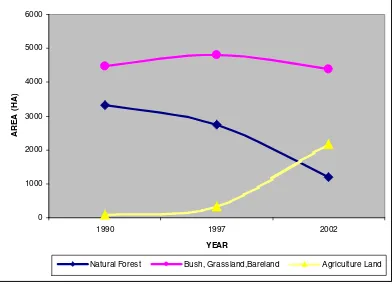
Trend of land use changes taken place in Cikepuh wildlife reserves has close relation to the dynamics of the community for the time period of 1990 – 2002 (Figure 15.8). In 1990 – 1997 period, forest land gradually decreases but in the period of 1997 – 2002 the fall is very dramatic. On the contrary in the same period Agriculture land (upland and paddy field) grow rapidly. This phenomenon is probably related to the multidimensional crisis happening in 1997-1998. In West Java after the Implementation of Regional Autonomy, there are uncertainty related to the Forest area management. It was reported that there is a conflict between the Regional Government with Perhutani (National Forest Estate) who are managing Production and Protection Forest in Java. The Regional Government urge to manage the forest on behalf of autonomy.
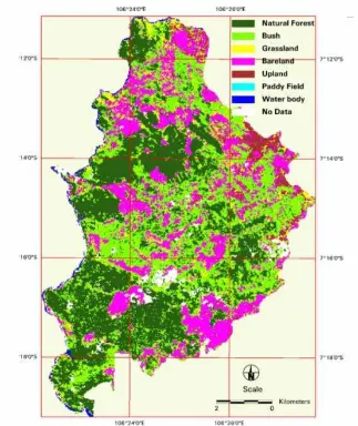
Spatial distribution of land-use and land cover in 1990, 1997 and 2002 is presented in Figure 15.9 Figure 15.10 and Figure 15.11.
In the period of 1990 to 1997, and 1997 – 2002, forest conversion is mostly to fulfil wood needs. This can be
ble 15.6. Changes on Land Use in 1990– 1997 Period (in Ha)
seen fro the dimension of land which is not taken care of in the form of bushes, grassland and bare land compared to the dimension of land use as cultivation areas (Tables 15.6 and 15.7). However, in 1997-2002, area for agriculture land increased significantly.
Ta
Forest 2,748.690 0.000 0.000 0.000 0.000 0.000 0.000
Bushes 439.110 2,094.390 89.280 28.710 6.210 6.840 14.760
Grass 43.200 360.270 54.000 7.920 2.610 1.710 6.210
Bareland 68.940 1,132.110 205.740 183.060 36.720 19.260 8.730
Upland 9.270 196.200 97.740 6.930 13.140 1.080 0.810
Paddy field 0.000 0.000 0.000 0.000 0.000 0.000 0.000
Water body 7.470 16.290 1.620 1.890 0.090 0.180 61.830
Forest 1,201.680 0.000 0.000 0.000 0.000 0.000 0.000
Bushes 1,072.710 1,840.950 224.550 397.890 75.780 0.000 11.610
Grass 130.050 247.320 85.320 120.510 51.840 0.000 0.540
Bareland 3.240 12.690 2.340 105.840 2.520 0.000 1.350
Upland 278.820 459.000 132.660 794.790 174.690 0.000 4.320
Paddy field 24.120 70.650 19.170 194.490 16.200 0.000 2.520
F igure 15.10. Land-use/land cover Cikepuh Wildlife Reserve in 1997 Fig . 1 5 .9 .
3. Case study 3 : Rawadano Nature Reserve
3.1. Social condition dynamics of the reserve
Rawadano reserve area is one of natural reserve in Banten Province which was established under GB (Besluit van den Gouverneur-Generaal) dated on 16 November 1921 No. 60 Staatsblaad 683. Administratively the reserve is located in 3 Sub-districts (Kecamatan), which are Kecamatan Padarincang, Kecamatan Mancak and Kecamatan Pabuaran, Kabupaten Serang, Geographically is situated in 0608' - 06011' latitude and 105056' - 106004' BT longitude, and elevation in 80 - 200 m above sea level. The are of the reserve is about 2500 ha.
Most of the community in the reserve now is farmer. Based on the statistical data. Population of Kecamatan Cinangka in 2000 was 50,729 inhabitant, or population density of about 413 persons/km2 with the annual population rate of growth 1.3%. Population of Kecamatan Padarincang in 2000 was 55,967 inhabitants, or 505 persons/km2, with the annual population rate of growth 1.98%. Population of Kecamatan Mancak in 2000 was 37,260 inhabitant, or of about 357 jiwa/km2, with the annual population rate of growth 2.69 %. Information concerning history of social condition changes of Rawadano is limited. Based on interview with the farmer in the reserve the farmer started to encroach the reserve since 1951. During the economical and political difficulties in the period of 1960 – 1969 and 1970 – 1979, the land occupation in the reserve greatly expanding. In 1984/1985, some farmers were transmigrated to Sumatra, however, some of them turning back to the reserve during the economical crisis (Table 15.8).
Table 15.8. Period of encroachment, number of family and size of agriculture land within the reserve No. Encroachment period Number of Farmer Number of family Mean Size of Land (Ha)
1 1950 – 1959 1 6 0.70
3.2. Trend on Land cover changes
Seven land-cover types were determined which are shrub and bush, orchard (mixed tree plantation), forest, dry field, inundated field, bare land, and build up area, Forest and grasslands were commonly observed land-cover within natural reserve. They mainly contain wetland grasses (Phragmytes karka) and other wetland shrubs and bushes.
F igure 15.12. Land cover changes in Rawadano nature reserve 1994 - 2000
Forest Paddy field Grassland Mixed tree plantation Barelands
2000 1997
4. Conclusion
1. Nature reserve encroachment have been occurring since the period before the implementation of decentralization
2. Before the area established as Wildlife reserve, some parts of the reserves area had been occupied by the community, which were neglected when the Wildlife reserve were established. This condition has created long term conflict with the wildlife reserve management. The facts is accordance to what Yamauchi (2005) found.
3. Forest area decrease significantly after 1997 (Balairaja and Cikepuh), when the economical turmoil occurred in Indonesia. The reason behind the fact that the economical crisis have gave significant impact on community who are living near the forest. Sunderlin (1999) found that two-thirds of the people in forested areas have become worse off during the crisis compared with their situation in the year before the crisis, the other finding is that small farmers are increasingly interested in clearing forests for perennial tree crops rather than raising food crops in shifting cultivation systems;
4. There is unsynchronized policy concerning to conservation/protected areas conservation among the institution in the regional government level. This is indicated by the development of some infrastructure within the reserve, after its establishment.
5. It is difficult to conclude that the forest encroachment is merely caused by decentralization, since many factors have came in the same time such as economical crisis, height demand of wood, and height price of cash crops (oil palm). The facts are accordance to Casson (1999) finding.
Reference
Casson, A. 1999. The Hesitant Boom: Indonesia’s Oil Palm Sub-Sector in an Era of Economic Crisis and Political
Change. Center for International Forestry Research.
Chevron, Texaco. 2005a. Indonesia Fact Sheet. (http://www.chevrontexaco.com/operations /docs/indonesia.pdf)
Chevron, Texaco. 2005b. Chevron History Exploration and Discovery
(http://www.chevron.com/learning_center/history/topic/explore/explore.pdf)
Darmawan, A. 2002. Perubahan lahan cagar alam Rawadano. Bachelor Thesis
Kartodihardjo, H. (without year). Sentralisasi dan tekanan eksploitasi hutan dalam pp no. 34/2002
Kompas. 28 September 2003. Cagar Alam Pun Jadi Sasaran (in Indonesian), Kompas, Jakarta
Mokhsen, N. 2003. Decentralization in the post new order era of indonesia. The 8th Commonwealth Advanced Seminar
was held in Wellington. New Zealand. 4 February to Friday 7 March 2003.
(www.vuw.ac.nz/.../Papers/2003/Nuraida%Mohksen%20Indonesia%20Decentralisation%20 Case%20Study.pdf)
Pikiran Rakyat. 25 June 2002. Merubah Paradigma Hutan Warisan Nenek Moyang Jadi Warisan Untuk Generasi Penerus. Dilema Penjarahan Hutan di Jawa Barat (in Indonesian), Pikiran Rakyat, Jakarta
Raharjo, Diah Y and A. Khan. (without year). Kontroversi substansi pp 34 tahun 2002 Sebagai proses pembelajaran
publik (unpublished)
Sunderlin, W.D. 1999. The effect of economic crisis and political change on Indonesia’s forest sector. 1997 – 1999.
Yamauchi, K. 2005. Conflict resolution mechanism in sustainable forest management: from case studies in Thailand.
indonesia and Malaysia. (www.iges.or.jp/en/fc/phase1/3ws-24-yamauchi.pdf)