Application of an Analytical Spectral Device (ASD) in Alteration
Mapping of the Seruyung Project, East Kalimantan, Indonesia
Aplikasi Analytical Spectral Device (ASD) pada Pemetaan Ubahan
Projek Seruyung, Kalimantan Timur, Indonesia
Atmasari Rura, Priyo Widekso, Arif Purnomo and Jesse Umbal
PT. Avocet Mining Services,
Jln.. Kol. Sugiono No. 24 Kotobangun Kotamobagu, Bolaang Mongondow, North Sulawesi
ABSTRACT
The Seruyung prospect is an advanced stage project targeting high sulphidation epithermal gold deposits and mineralized diatreme structures hosted in an interbedded andesitic to dacitic volcanic and epiclastic sequence, located in the Nunukan District, East Kalimantan Province. This paper describes briefly the application of an Analytical Spectral Device (ASD) in the alteration mapping conducted at the Seruyung Project. The aim of the ASD study was to characterize clay alteration assemblages, their lateral distribution and vertical persistence along drill intercepts, and to identify distribution patterns that could be used to vector towards potential gold mineralization. The ASD instrument is a field portable spectrometer that allows the identification of minerals by measuring their vibrational spectral absorption features. These absorption features are attributable to the variations in composi-tion, crystallinity, and orientation of the minerals. Samples that can be analysed include rocks and powder collected from outcrop, soil, drill hole samples, and hand auger samples with flat or a near flat surface. The method of analyzing samples entails placing the mineral probe on a flat surface of the material where a spectrometer scan can be taken. The spectral measurements are able to discriminate low and high temperature species of clay minerals in the studied area. The main alteration minerals identified in drill hole and surface samples include alunite, silica, quartz, kaolinite, pyrophyllite, illite-smectite, and minor illite. Oxidation minerals, such as haematite, limonite, and goethite were also identified. The alteration mineral assemblages exhibit a zoned lateral and vertical distribution typical of high sulphidation epithermal deposits. The alteration pattern comprises a massive/vuggy silica core grading outwards into advanced argillic and argillic alteration haloes. Gold mineraliza-tion is commonly associated with vuggy and massive silica zone, and to a minor extent within the advanced argillic zone. Pyrophyllite and dickite commonly occur proximal to the margins of hy-drothermal breccia structures, suggesting their possible use as vectors toward potential high grade feeder structures masked on the surface by soil and weathered overburden. The presence of discrete pyrophyllite clays along the peripheral margin of inferred diatreme or maar features suggest that related arcuate structures are potential path ways for hot ascending acid fluids, and thus, potentially can be mineralized. The spatial distribution of “hot” clays along these arcuate features should further be compared with results of detailed geological mapping and geophysical surveys and validated by trenching prior to drill testing.
Keywords: Analytical spectral Device (ASD), Seruyung, East Kalimantan, sulfidation epithermal gold
SARI
Projek Seruyung merupakan proyek tahap lanjutan yang menargetkan deposit emas epitermal sulfida
tinggi dan struktur diatrema termineralisasi dalam runtunan lapisan vulkanik dan epiklastika andesit - dasitik, di Distrik Nunukan, Provinsi Kalimantan Timut. Makalah ini secara ringkas menjelaskan aplikasi Analytical Spectral Device (ASD) pada pemetaan ubahan yang dilaksanakan di Proyek Seruyung. Maksud studi ASD ini adalah untuk mencirikan kumpulan ubahan lempung, distribusi
lateral dan vertikalnya secara terus-menerus selama pengeboran, dan untuk mengidentifikasi pola
merupakan spektrometer portable lapangan yang dapat mengidentifikasi mineral dengan mengu -kur absorpsi spektral vibrasionalnya. Gambaran absorpsi ini diakibatkan oleh variasi komposisi, kristalinitas, dan orientasi mineral. Percontoh yang dapat dianalisis meliputi batuan dan serbuk yang dikumpulkan dari singkapan, tanah, percontoh sumur pemboran, dan percontoh dari bor tan-gan dentan-gan permukaan rata atau hampir rata. Metode analisis percontoh memerlukan penelitian mineral yang diletakkan pada permukaan rata, dengan demikian scan spektrometer dapat dilakukan. Pengukuran spektral dapat membedakan spesies mineral lempung suhu rendah dan tinggi di daerah
penelitian. Mineral ubahan utama yang teridentifikasi pada percontoh sumur bor dan permukaan meliputi alunit, silika, kuarsa, kaolinit, pirofilit, ilit-smektit, dan ilit minor. Mineral oksidasi, seperti hematit, limonit, dan goetit juga teridentifikasi. Kumpulan mineral ubahan menunjukkan distribusi vertikal dan lateral yang terzonasikan, khas deposit epitermal sulfidasi tinggi. Pola ubahan terdiri
atas inti silika masif/vuggy bergradasi keluar ke argilik lanjutan, dan halo ubahan argilik. Mineral-isasi emas biasa berasosiasi dengan zona silika masif dan vuggy, dan sampai tingkat minor berada
pada zona argilik lanjut. Pirofilit dan dikit biasa terdapat dekat batas struktur breksi hidrotermal,
mengesankan kemungkinan penggunaannya sebagai vektor terhadap struktur feeder tingkat tinggi
di permukaan tertutup oleh tanah dan lapisan lapuk. Kehadiran lempung pirofilit yang berbeda di
sepanjang batas periferal diatrema atau maar terduga mengesankan bahwa struktur arkuat terkait merupakan jalur yang potensial bagi cairan panas asam yang mengalir naik, dan karena itu poten-sial dapat dimineralisasikan. Distribusi spapoten-sial lempung panas di sepanjang arkuat ini hendaknya
dibandingkan dengan hasil pemetaan geologi terperinci dan survei geofisika serta divalidasi dengan
trenching sebelum uji pemboran.
Kata kunci: Analytical Spectral Device (ASD), Seruyung, Kalimantan Timur, emas epitermal sulfidasi
INTRODUCTION
An understanding of the type and distribu-tion of various alteradistribu-tion mineral assem-blages is an important component for the successful exploration of hydrothermal ore deposits. Conventional geological mapping tools and techniques are able to provide qualitative descriptions of the alteration minerals by their physical characteristics
(e.g. kaolinite, alunite, etc.), but are con
-strained and limited in defining important
compositional and attendant crystallinity
variations by virtue of their fine-grained
nature. The application of spectral geology
offers a more specific quantitative analytical
solution to these limitations.
Spectral geology is a specialized field that
applies the science and techniques of reflec
-tance spectroscopy to identify spectrally
distinct and physically significant features
of different rock types and surface materi-als, their mineralogy and their alteration signatures. Spectral signatures are
mea-sured using specialized sensors that record
either solar or artificially provided radiation reflected from the surface of materials.
Many materials absorb radiation at
spe-cific wavelengths that appear as diagnostic
troughs in a spectral curve. It is this characte r istic absorption spectral features and pat-terns that enable discrimination between
individual materials (Kruse, 1994). The
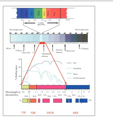
range of wavelength most suitable for the discrimination of geological materials and oil slicks includes those in the visible and
near-infrared (VNIR), short- wavelength infrared (SWIR), and the mid or thermal infrared (TIR) wavelengths, while the characteristic fluorescence of hydrocarbons occurs in the ultra-violet (UV) spectral region (Figure 1).
The positions of the wavelength are deter-mined by the cation and the bond length. The ionic radius of the cation determines the length of the chemical bond between
the cations and to the molecule (e.g. such
it is attached. Spectroscopy measures the vibrational energy of the bond, which
vi-brates at discrete wavelengths specific to the mineral bond length. For instance, the
Al-OH bonds lie within the 2200 μm re
-gion, the Fe-OH bonds within 2280 - 2295 μm for clays, and the Ca-CO3 bonds at around 2334 μm.
The basic principle of spectral identification
is pattern and wavelength recognition and in
particular, the presence of a specific feature
or minima at a certain wavelength or band. The characteristic features of a mineral
spectra are influenced by its composition,
degree of crystallinity, and orientation. In
this respect, a mineral spectral signature can be useful to assess the mineral compo-sitional and crystallinity variations, as well as possible mixing with associated mineral assemblage.
Measurements of the spectral properties of a mineral were previously conducted in a laboratory. In the last decade, however,
several field portable spectral measuring de
-vices had been developed and successfully
tested in the field and are now commercially
available for use by exploration companies.
At present, field portable spectrometers provide spectral information on fine-grained
minerals with spectral signatures within
578
Figure 1. This plot shows the region of the electromagnetic spectrum, which is of interest to reflectance spectros
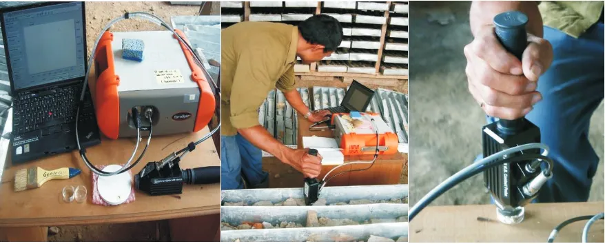
Figure 2. ASD instrument set showing spectrometer, mineral probe, laptop, spectralon standard, and petrie dish.
ASD measurements on drill core and powder samples.
the visible (0.4 - 0.7 μm), near (0.7 - 1.3 μm), and shortwave infrared (1.3 - 2.5 μm) wavelengths. Within this wavelength
range, a multitude of minerals germane to the exploration and assessment of mineral
deposits can be identified.
There are currently several commercially
available field portable spectrometers, with
two of the most popular and widely used brands being the Analytical Spectral Device
(ASD®) and the Portable Infrared Mineral
Analyzer (PIMA®). Both devices have been
evaluated by Avocet, eventually deciding
on acquiring an ASD in 2008, which it has
successfully integrated into its exploration projects ever since.
This paper briefly describes the application
of ASD techniques in mapping the alteration zones at Seruyung Project in Kalimantan to complement exploration data acquired from geological mapping, geochemistry,
geophysical (i.e. IP and ground magnetic),
and scout drilling. The aim of the ASD study was to characterize clay alteration minerals, their associated assemblages, their lateral distribution and vertical persistence, and to identify distribution patterns that could be used to vector towards potential gold mineralization.
METHODOLOGY
Equipment and Set-up
The ASD TerraSpec® Pro is a portable
spectrometer designed for field analyse of
soil, rock, and drill (i.e. core and RC)
samples. The device consists of three main components - a spectrometer, mineral probe, and laptop. A typical equipment set-up is
shown in Figure 2.
The spectrometer is the main analytical component encased in a durable, light-weight, and portable casing. It can process a full spectral range between 350 - 2500 μm at a spectral resolution of 6 - 7 μm and is capable of rapid data collection at 1/10th of a second per spectrum. The instrument uses both DC and AC power supply and is very tolerant of voltage and frequency
fluctuations.
The mineral probe is a handled and work-station component of the equipment and connects to the spectrometer unit using a
fiber-optic cable. It features a built-in light
is composed of sapphire, thus, is generally resistant to scratching by most materials. It comes with a spectralon - an optical standard reference, for calibration purposes.
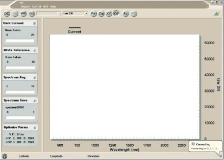
The equipment has a dedicated laptop linked to the spectrometer using an Eth-ernet cable and has four pre-installed ASD TerraSpec® Pro supported computer soft-ware programmemes - High Contrast Field
SpecPro RS3, ViewSpecpro, SpecWin, and
SpecMin. High Contrast FieldSpecPro RS3
is the software programmeme for
collect-ing reflectance measurements directly from
the spectrometer and translating the
spec-trum data into an ASD file (i.e. as an .sco
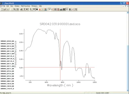
extension) format (Figure 3). The spliced
data are analysed using the ViewSpecPro
software programmeme. For generating,
viewing, manual analysis and interpreta-tion of spectral data, the SpecWin software
programmeme is used (Figure 4). Individual
spectral images can be referenced from an ASD spectral database catalogue accessible using the SpecMin software programmeme.
While the equipment is tolerant of varying temperature conditions, overheating could affect the quality of the spectra acquired. Thus, it is advisable to have the equipment shaded from direct sunlight when working outdoors and the unit should be given time to cool down after several hours of
continu-ous measurements. Rooms with fluorescent
light illumination should be avoided when working indoors as this may cause major interference in the spectra. It is advisable to have the equipment run for half an hour to stabilize prior to use and connecting to the laptop. Oversaturation can occur and in this situation recalibration using the optical standard is required.
Figure 3. High Contrast FieldSpecPro RS3software screen view for preliminary viewing and translating
Sampling Design and Sample Materials
The ASD samples collected for this study
comprised soil (i.e. both matrix and
frag-ments), rock, and core samples. These
samples constitute fresh, weathered, and altered rocks found within the prospect. All samples were sun-dried to allow evapora-tion of excess water prior to measurement.
A total of 685 samples were collected for
this study comprising of 64 surface (i.e.
soil, outcrops, and floats) and 621 core
samples.
Rock and core samples with facet faces
having a minimum flat or near flat surface
area of 20 mm x 20 mm dimension (i.e.
cor-responding to the probe’s sensor window
area) were selected to avoid getting noisy
spectra during measurement. Rock sam-ples were taken from all known outcrops
and boulder floats in the project site and
cleaned of adhering weathered materials prior to measurement. Core samples were taken at preselected intervals in each drill hole to be as representative as possible of alteration types and changes. In the case of polymictic breccias, collection was undertaken to get a representative sample of all the component fragments as well as the matrix. This is to ensure that possible differences and/or commonality in the al-teration minerals inherent in the breccias are captured.
Soil samples were collected both selectively and randomly along grid fence-lines, roads, and foot trails crisscrossing the project area. Soil samples were presegregated into its weathered matrix and clast fragments. The dried clast fragments were cleaned of possible weathered material clinging into its outer surface. Both soil matrix and clast fragments were measured.
Measurement Procedure
and DataCompilation
Sample measurements were conducted
in-doors in the Seruyung camp office and core-shed facilities, and at the Kotamobagu office,
North Sulawesi. All samples were cleaned of potential contaminants and sun- dried.
Prior to measurement, each rock, core or soil clast was examined for homogeneity of its components and alteration. Samples which components and alteration appear to be heterogeneous had each of its component and/or alteration facets separately marked for measurements.
Soil material was placed in a petrie dish
in quantities sufficient to cover the entire
bottom of the dish. This is to ensure that no extraneous light source enters the sen-sor window that can degrade the spectra acquired.
Measurement is made by placing the probe sensor window in contact with the sample
medium (i.e. rock, core, and soil). At least
two measurements are taken for each sample or target sample facet surface for rock and core samples and at least two measurements each for soil material and its associated clast types. Results were compiled and analyzed using a combination of the ASD preinstalled software programmemes.
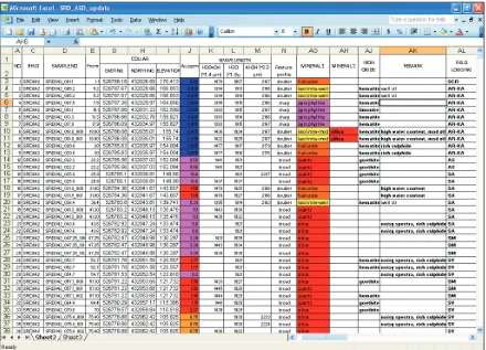
The final results were tabulated into a Mi
-crosoft Excel spreadsheet (Figure 5). The
results were later converted into ArcGIS
shapefiles for graphical representation and
ease in spatial analysis.
GEOLOGICAL BACKGROUND
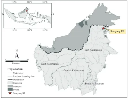
Regional Setting
The Seruyung prospect is an advanced stage project targeting high sulphidation
Figure 6. Project location map. Explanation
N
Major river
Province boundary line Border line
Indonesia
Malaysia Brunai
Seruyung KP
Kilometres
0 300
West Kalimantan
East Kalimantan
Central Kalimantan
South Kalimantan
105oE 120oE 135oE 105oE 120oE 135oE
0 0
0 0
o o
Seruyung KP
epithermal gold deposits and mineralised diatreme structures hosted in an interbedded andesitic to dacitic volcanic and epiclastic sequence. The prospect is located in the dis-trict of Nunukan, East Kalimantan Province
(Figure 6).
The Seruyung prospect is situated along the SW extension of an ENE to NE trending volcanic arc that passes through Tawau in Malaysia into the Tawi-tawi-Sulu volcanic island group in the Philippines. This vol-canic arc is associated with Miocene to Recent (?) south-eastward subduction of the Sulu Sea Plate.
The oldest rocks are a Pre-Tertiary to Pa-leogene sedimentary sequence intruded by Cenozoic intrusions that comprise most of the Central Highland region of Kalimantan. The eastern foot slopes of the highlands
are bounded by N-S to NNE trending basin
margin faults. The flat estuarine terrain to
the east of the mountain range is underlain by Late Paleogene to Neogene sedimentary sequences associated with sedimentation within the Tarakan Basin. The northern and southern margins of the basin are bound by NW-trending regional arc-transverse faults referred to as the Sempurna and
Maratua-Mangkalihat Fault Zones, respectively.
Miocene and younger Pliocene volcanic rocks sporadically outcrop within the broad
estuarine tidal flats that are for the most part
covered by extensive Quaternary alluvium.
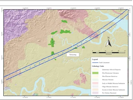
The main regional structure is an ENE fault referred to as the Sembakung
Linea-ment (Figure 7). This fault can be traced
Figure 7. Regional geology map.
Plio-Pleistocene Volcanics
Mio-Pliocene Intrusives
Miocene Volcanis
Early to Middle Miocene Sediments
Oligo-Miocene Intrusives
Eocene to Early Miocene Sediments
Pre-Tertiary Basement
116o50'0"E 117o0'0"E 117o10'0"E 117o20'0"E 117o30'0"E 116o50'0"E 117o0'0"E 117o10'0"E 117o20'0"E 117o30'0"E
3
The prospect area is underlain by sub-hor-izontal to gently-dipping bedded andesitic to dacitic tuffs interbedded with minor
epi-clastic and breccia units (Williams, 2000; PT Sago, 2007; Bautista and Munajat, 2007;
Hardjana et al., 2009). Crystal-, ash-, and
lithic-tuffs comprise the individual units within the volcanic sequence. The ages of these volcano-epiclastic units are poorly known, but could well range from Mio-cene to PlioMio-cene. Young and fresh-looking porphyritic basaltic andesites crop-out in nearby hills and may well correlate with Quaternary basaltic andesites regionally found in East Kalimantan. The youngest units are recent unconsolidated colluvial, alluvial, and swamp deposits. The areal distribution of these rock units is shown in
Figure 8.
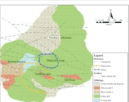
Several breccia units were mapped in out-crops and recognized in drill cores. Their textural characteristics indicate a wide range of origin that include hydrothermal breccias, fault breccias, and diatreme brec-cias.
The structural fabric is dominated by roughly E-W trending and cross-cutting NW to WNW trending dextral faults and lineaments. The most prominent of these structures is an E-W dextral fault, infor-mally referred to here as the Seruyung
Fault, which forms a linear cliff face along
Figure 8. Geological map of the Seruyung Prospect.
0 50 100 200 300 400 metres
Legend Structure
Lineament
Depression
Dome
Feature
Topo contour 5m
Lithology
Colluvial/alluvial deposits
Breccia unit 1
Breccia unit 2
Lithic tuff
Crystal tuff
Ada Raye Southern area
Main silica cap Northern colluvium
N
400m-wide semicircular depression located in the western portion and a 200m-wide oblate dome-like feature at the summit area of Mount Seruyung.
The general alteration mineral assemblages and their distribution patterns are typical of high sulphidation epithermal deposits. Hy-drothermal alteration mineral assemblages comprise a massive silica and vuggy silica
core (i.e. Main Silica Cap) partially envel
-oped by an advanced argillic alteration halo
(alunite- pyrophyllite) that grades outward
towards a broader marginal intermediate alteration halo that is kaolinite-dominated.
Sulphides, mostly pyrite, are typically
fine-grained and commonly oxidised. Enargite is present, but has been oxidised to scorodite
(Sinclair Knight Merz, 2009; Latanzi et al.,
2008).
RESULTS AND DISCUSSIONS
The main alteration minerals identified by
ASD from surface (i.e. rocks and soils) and
drill hole samples include alunite, silica, quartz, kaolinite, and pyrophyllite. Illite-smectite and illite tends to be minor altera-tion constituents. Similarly, dickite occurs as another minor constituent with kaolinite and pyrophyllite. The spatial distribution of surface samples and those from cores are
shown in Figure 9.
Alteration Minerals
The representative alteration minerals in the prospect include alunite, quartz, silica, kaolinite, pyrophyllite, illite, illite-smec-tite, and dickite. The characteristic spectral signatures of some of these common
Figure 9. Location map of surface and drill hole samples and results of ASD alteration identification.
Clay alteration minerals (ASD) outcrops, auger, and drill holes
Outcrop & Auger Alteration Mineral K-alunite
Drill Hole Alteration Minerals K-alunite
Outcrop Alteration Mineral (second) EXPLANATION
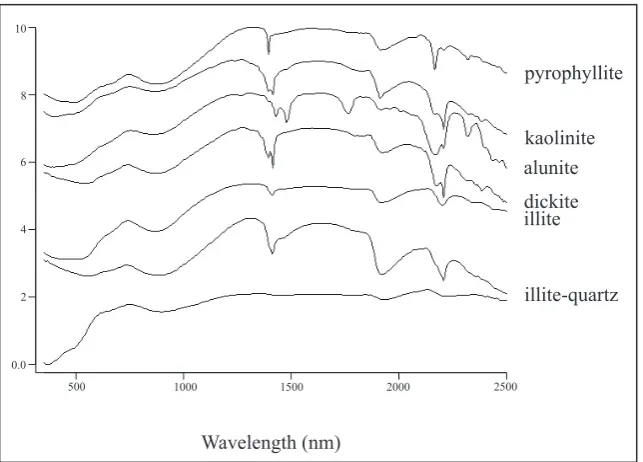
Figure 10. Spectra of common alteration minerals in the Seruyung prospect.
0.0
The spectral signature of alunite is recogniz-able by the presence of a diagnostic doublet
feature at the 1425 - 1439 μm and 1478-1495
μm wavelength and triplet feature within the 2200 μm wavelength region. The two
minima range from 1425 - 1439 and from 1478 - 1495. The wavelength at the 1478 -
1495 μm minima can be used to discriminate
between the potassium (i.e. 1478 - 1486 μm)
un it e varieties. Alunite is one of the most common alteration minerals measured in the samples collected. Its presence sug-gests temperature of formation ranging from <100oC – 300oC and acidic conditions
(i.e. pH<4). The dominant alunite species
is potassium alunite (i.e. hypogene), which
is commonly associated with
magmatic-derived acidic hydrothermal fluids. Sodium
alunite was recognized mostly from surface samples, but is minor and generally subor-dinate to potassium alunite. The presence of a low water feature in the spectral signature in some of sodium alunite observed may suggest a supergene origin or the presence
of an associated clay (Hauff, 2005). Alunite
occurs generally in association with kaolin-ite, pyrophyllkaolin-ite, silica, and quartz. It was
also commonly observed as in-fill in vugs
and open cavities.
Similar to alunite, kaolinite is ubiquitous throughout most of the outcrops and cores samples measured. It is recognizable by its
characteristic doublet features at the 1392 -
1402 μm and 2162 - 2168 μm wavelengths. Both high and low crystalline varieties
were observed. Crystalline kaolinite (i.e. identified on the basis of small minima
within the 1810 - 1848 nm spectral wave
-length) typically occurs in association with
alunite, pyrophyllite, and to a minor extent dickite. In contrast, the low crystalline va-riety was commonly observed in surface
pH (i.e. <4) conditions similar to alunite.
Pyrophyllite was observed in most drill hole samples and outcrop samples taken mostly within the Main Silica Cap and Western
Breccia Zone, but is less common than
alunite, kaolinite, and silica. Pyrophyllite occurs mostly in association with potassium
alunite, silica, quartz, and crystalline ka-olinite. Discrete occurrences of pyrophyllite were observed only in outcrops mapped in association with local structures or inferred lineaments.
Silica and quartz are differentiated here as different crystalline forms of SiO2. They can be discriminated from each other by the presence of broad trough feature in their spectral signatures at wavelengths of 1420 - 1426 μm and 1443 - 1447 μm, respectively. Silica and quartz occur as the dominant alteration minerals in outcrops and drill hole intercepts located within the Main Silica Cap area. The prominent peak and resistant nature of Mount Seruyung is attributed to the pervasive silica alteration at its summit. Observed gold - sulphide mineralization is also commonly associated with volcanic units having vuggy silica and silicified breccia alteration textures. Elsewhere in the prospect, these two minerals occur as subordinate alteration minerals in associa-tion mostly with alunite and kaolinite.
Dickite can be recognized by the pres-ence of a diagnostic doublet features with
minima at 1378 - 1386 μm and 2180 - 2186
μm wavelength. The presence of another
very small minima at the 1798 - 1836 μm
wavelength is indicative of well developed crystallinity in dickite. Dickite primarily occurs as minor alteration constituent as-sociated with kaolinite and pyrophyllite in several drill holes samples and surface samples. Crystalline dickite was found as-sociated with crystalline kaolinite and/or pyrophyllite. Low crystallinity dickite was observed to be generally associated with low crystallinity kaolinite and to a minor extent with illite- smectite.
Illite can be recognized by the presence of a
sharp feature at the 1408 - 1414 μm and
2190 - 2220 μm wavelengths. The
2110 μm indicates the illite is crystalline.
Illite-smectite can be differentiated by a broad feature at the 1404 - 1415 μm and
2188 - 2192 μm wavelengths. Minor illite
was observed mostly in some of the drill holes and typically is of the poorly crystal-line variety. It occurs mostly in association with kaolinite. Illite - smectite showed similar association with kaolinite and in most instances was observed in deeper drill hole samples. In outcrops, illite - smectite clays were observed only on the northwest margin of the prospect.
Chlorite is recognisable by the presence of a broad feature at 2242 - 2262 μm and 2314
- 2368 μm wavelengths. Chlorite is the least
minor alteration mineral identified and was
only found deep in one drill hole in associa-tion with illite and illite-smectite.
Oxide minerals include haematite, limonite, and goethite. In addition, scorodite, an
hy-drated iron arsenate, was identified petro
-graphically (Sinclair Knight Merz , 2009) and
probably originated as the oxidised alteration mineral of enargite with the iron provided by
dissolution of pyrite (Lattanzi et al., 2008).
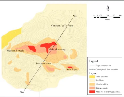
Alteration Mineral Assemblages and Patterns
The ASD results were subsequently adopted
to further refine the alteration boundaries
delineated from previous geologic mapping activities. At least three main alteration zones are recognized on the basis of altera-tion mineral associaaltera-tions and assemblages: vuggy and massive silica, advanced argillic, and argillic zones. The distribution of these
alteration zones is shown in Figure 11.
NE
Northern collovium
SW
Main silica cap
Southern area
Ada Raye
Legend
Topo contour 5m
Conceptual line ssection
Layer
Illite-smectite
Kaolinite
Alunite-silica
Silica-alunite
Massive silica/vuggy silica
Metres
0 50 100 200 300 400
N
Western breccia
The outermost propylitic alteration zone having the chlorite- illite±illite-smectite alteration assemblage was encountered only at the base of one hole. The presence of potassium alunite, together with pyro-phyllite and high crystalline kaolinite, suggests a magmatic origin for the acidic
hydrothermal fluids.
The vuggy and massive silica zone has quartz-silica±alunite±sulphides as the main alteration minerals. It is the primary altera-tion style in the Main Silica Cap area in the summit of Mount Seruyung and on the large
boulder floats that litter the Northern Col
-luvium area of the prospect. Gold miner-alization is commonly associated with this alteration zone.
The dominant alteration minerals in the ad-vanced argillic zone comprise silica-alunite-pyrite±pyrophyllite±kaolinite±dickite. It envelops the vuggy/massive silica zone and forms discrete patches of alteration associated with local dilational structures in the prospect area. The kaolinite and dickite minerals occurring in this zone are typically of the crystalline variety.
The argillic zone has kaolinite ± quartz ± illite ± illite-smectite ± dickite as its alteration mineral assemblage. Kaolinite and dickite are typically of low crystal-linity. The zone distribution is restricted to the NW edge of the prospect and is en-countered mostly at the bottom intercepts of drill holes.
These alteration assemblages form a general zonal distribution pattern comprising a mas-sive/vuggy silica core progressively grading outward into enveloping regions character-ised by advanced argillic and argillic
altera-tion zones, respectively. On plan (Figure 11),
the general alteration pattern is asymmetric with the enveloping main advanced argillic zone forming an irregular “tadpole” shape halo suggesting that ascending acidic
hydro-thermal fluids were strongly influenced by
fault structures and the presence of
favour-able lithology. On SW-NE section (Figure 12), the alteration outline mimics closely the
classical zoned mushroom- shaped alteration pattern commonly observed in structurally intact high sulphidation epithermal deposits with a narrow, downward tapering “stalk“ corresponding to the geometry of the
hydro-Figure 12. Sectional view of the alteration in Seruyung prospect. Western breccia zone area
Main silica cap area
thermal breccia unit (i.e. feeder structure)
intersected by drill holes.
Mineralization
The mineralization style in Seruyung is typical of a replacement style, high sul-phidation epithermal system, where gold grades out from high-grade feeder structures
to a lower- grade advanced argillic (quartz-alunite-pyrite) alteration halo.
Comparison of gold tenor and alteration type from outcrops and drill core samples suggests that gold values are commonly el-evated within rock units that exhibit vuggy and massive silica alteration. In particular,
significant gold grades are commonly ob
-served in silicified breccia units interpreted
as structural feeders.
Discrete elevated gold values are also noted within the advanced argillic altered rocks, but are of lower grade. More commonly, gold within this zone occurs where alunite is dominant and there is attendant localized
silicification along structures.
In contrast, gold within the argillic zone is commonly absent. Where elevated gold values are found in discrete patches within this zone, they are commonly associated with minor dilational features along local fault structures.
The presence of pyrophyllite and dickite appears to have no direct bearing on gold grade, though its presence is commonly observed near and immediately peripheral to the margins of drill hole intercepts and
outcrop samples that have significant gold
grades. This spatial relationship highlights the potential use of identifying these “hot” alteration clay minerals for vectoring into possible high grade structures.
The presence of pyrophyllite along the inferred trace and margin of a diatreme
structure in the Western Breccia Zone sug
-gests the possibility of a nearby structural feeder. This concept is currently being tested - the presence of pyrophyllite and a coincident IP resistive signature, by initially trenching across and eventually drilling this inferred margin of a diatreme structure. If successful, this relationship can be useful for prospecting areas where outcrops are
relatively sparse and there is significant
overburden that could mask potential high sulphidation epithermal deposits.
SUMMARY AND CONCLUSION
Application of ASD equipment and tech-niques has been useful in alteration mapping and in understanding the mineralization at the Seruyung prospect. Previously, mapped alteration zone boundaries were further
refined with a better understanding of the
compositional and crystallinity variation of associated alteration minerals.
The common alteration minerals identified
are alunite, quartz, silica, kaolinite, and py-rophyllite. Dickite, illite, and illite-smectite tend to be minor with traces of chlorite
identified deep in one drill hole. Oxides
include haematite, limonite, and goethite. The presence of potassium alunite and pyro-phyllite suggests a magmatic origin for the
acidic hydrothermal fluids associated with
the alteration and mineralization.
Three main alteration zones were recog-nized on the basis of alteration mineral associations and assemblages. These in-clude a central vuggy and massive silica
zone (quartz-silica ± alunite ± sulphides)
enveloped by an advanced argillic zone
(silica-alunite- pyrite ± pyrophyllite ± ka
-olinite ± dickite) that grade outward into a broad outer argillic zone (kaolinite ± quartz
± illite ± illite-smectite ± dickite). The pro
that typically lies peripheral to the argillic zone was encountered deep in one drill hole.
The alteration pattern is generally asym-metric and elongated, suggesting that the movement of the ascending acidic
hydro-thermal fluids was strongly influenced by
fault structures and the presence of favour-able lithologic units. The form, zoned dis-tribution, and associated alteration mineral assemblage are typical of high sulphidation epithermal deposits.
Mineralization in Seruyung is typical of a replacement style, high sulphidation epith-ermal system where gold grades out from high-grade feeder structures to a lower- grade advanced argillic-altered lithologies.
The comparison of gold tenor with altera-tion mineral assemblages indicates favour-able gold grades within the vuggy and mas-sive silica zones, particularly where the host lithologies exhibit breccias textures. Gold mineralization occurs within the advanced argillic zone though at a lower grade.
The presence of pyrophyllite and dickite has no direct bearing on gold tenor. However, these “hot” clays, particularly their crystal-line varieties, commonly occur as constitu-ent alteration minerals peripheral to outcrops
and drill intercepts that showed significant
gold grades. This relationship highlights the potential of using these clay minerals in vectoring towards potential high-grade feeder structures in similar high sulphida-tion epithermal deposits.
ACKNOWLEDGEMENT
The authors wish to express their appreciation to the management of PT Avocet Mining Services and PT Sago Prima Pratama for allowing them to share the results of their ASD study in the Seruyung Prospect. The development and writing of this paper would not have been possible without the technical support, review, and encouragement of Boyet Bautista, Jim
Sweeney, and Iip Hardjana. The authors also extend
their appreciation to Peter Flindell for his critical
review and constructive suggestions, which greatly improved the technical quality of the paper. The au-thors would also like to acknowledge the assistance and cooperation of the Seruyung Exploration Team during the implementation of this study.
Special thanks also go to the anonymous MGEI reviewer for the comments and suggestions, which further improved this paper.
REFERENCES
Arribas, J.R., 1995. Geology, geochronology, fluid
inclusions and Isotope geochemistry of the Rodalqui-lar Gold Alunite Deposit, Spain. Econimic Geology,
90. p.795-882.
Arribas, J. R., 1995. Characteristic of high sulfidation epithermal deposits and their relation magma fluid.
Mineralogical Association of Canada Course, 23.
Bautista, B. and Munajat. I., 2007. Project.
Evalua-tion; Summary. ABM internal report, 15pp.
Corbett, G. J. and Leach, T. M., 1995. SW Pacific
Rim Au/Cu systems: Structure, alteration and min-eralization.
Hardjana, I., Widekso, I., Desarona, M., Purnomo,
A., Rura, A., and Umbal, J., 2009. Phase I explora
-tion programmeme and scout drilling report. ABM internal report, 73pp.
Hauff, P.L., 2005. Applied reflectance spectroscopy. Spectral International Incorporated, technical
docu-ment to accompany spectral libraries and identifica
-tion softwares.
Kruse, F.A., 1996. Identification and mapping of min
-erals in drill core using hyperspectral image analysis
of infrared reflectance spectra. International Journal
of Remote Sensing, 17 (9), p.1623-1632.
Lattanzi, P., S. Da Pelo, E. Musu, D. Atzei, B.
Elsener, M. Fantauzzi, and A. Rossi, 2008. Enargite
oxidation: A review. Earth Science Reviews, 8,
p.1-4, p.62-88.
Pontual, S., 2007. Spectral Analysis and its applica-tion to exploraapplica-tion and mining.
Sinclair Knight Merz (SKM), 2009. Petrology of 12
samples from Seruyung for Avocet Mining. Unpub-lished internal report prepared for Avocet Mining Ltd., 51pp.
Thomson, A.J.B., Hauff, P.L., and Robitaille, A.J.,
1999. Alteration Mapping in Exploration:
Applica-tion of short wave infrared (SWIR) spectroscopy.
Society of Economic Geologists, Newsletter, 39.
White, N.C. and Hedenquist, J.W., 1995.
Epi-thermal Gold Deposits: Styles, Characteristics and Exploration. SEG Newsletter, 23, p.1, 9-13.
Williams, H. 2000. Seruyung Geological Model and
Implications for Further Exploration. Unpublished