© 2015 Faculty of Humanities, University of Indonesia
The authors may be contacted at: [email protected] (Allan F. Lauder), mia.lauder@ gmail.com (Multamia R.M.T Lauder). More information about the authors can be found at the end of the article.
Ubiquitous place names
Standardization and study in Indonesia
Allan F. Lauder and Multamia R.M.T. Lauder
Abstract
Place names play a vital role in human society. Names exist in all languages and place names are an indispensible part of international communication. This has been acknowledged by the establishment of the United Nations Group of Experts on Geographical Names (UNGEGN). One of UNGEGN’s tasks is to coordinate international efforts on the proper use of place names. Indonesia supports this effort and through its National Geospatial Agency (BIG). Place names are also of interest as an object of study in themselves. Academic studies into place names are found in linguistics, onomastics, philosophy and a number of other academic disciplines. This article looks at these two dimensions of place names, standardization efforts under the auspices of international and national bodies, and academic studies of names, with particular reference to the situation in Indonesia.
Keywords
Place names, onomastics, toponymy, name standardization, naming principles, generic place terms, local languages, exonyms, etymology, orthographic development.
Introduction
1Names are ubiquitous in society, an indivisible part of language and our ability to communicate and relate to the world. Names live on across generations. Even when we die, the lexical traces of our existence, our personal name and the place name of our birth, can be found on our birth certificate, national ID card, marriage license, death certificate, and tomb stone (Kadmon 2000). Place names can be particularly persistant and some we use today, like the light of a star that reaches our eyes, have travelled across the centuries. When we encounter them, we are, without knowing it, seeing into the past, to the time of their formation.
Names are studied in a discipline called onomastics (or onomatology) which traces its roots to a branch of linguistics called historical comparative linguistics. Onomastics focuses on word histories, or etymology, and also the meanings of names. Onomastics investigates proper names – primarily personal names and place names. The study of personal names is technically referred to as anthroponymy, and that of place names as toponymy. This article focuses on place names. The first part of the article looks at the international and national governance of place names. The second part looks at the academic perspective.
The United Nations Group of Experts on Geographical Names (UNGEGN)
The importance of place names in society has been recognized by the United Nations which set up an organization to deal with them. The problem of the standardization of geographical names was first raised during the debates of the United Nations Economic and Social Council (ECOSOC) in 1948. In 1955, ECOSOC resolution 715A (XXVII), which was produced at the First Regional Cartographic Conference for Asia and the Pacific, requested the Secretary-General to encourage nations to take part in the international standardization and co-ordination of geographical names, to establish an organization that could take responsibility for this and to create a body of experts in supporting fields.
The First United Nations Conference on the Standardization of Geographical Names (UNCSGN) convened at Geneva from 4 to 22 September 1967. After a second conference in 1972, the ad hoc experts group was formalized as the United Nations Group of Experts on Geographical Names (UNGEGN),2 and tasked with carrying forward the program of cooperation between countries. Today, UNGEGN is one of the seven standing expert bodies of ECOSOC3 (UNGEGN 2014).
The United Nations Group of Experts on Geographical Names (UNGEGN) was established by the United Nations to promote and oversee international cooperation on the consistent worldwide use of accurate place names. Consistent use of accurate place names is an essential element of effective communication worldwide and supports socio-economic development, conservation and national infrastructure.
To encourage the consistent use worldwide of accurate place names, UNGEGN is involved in:
• outreach to countries that do not have name standardization mechanisms, databases (digital or manual) or national gazetteers;
• supporting the development of single romanization systems; dissemination and wider
2 UNGEGN has its headquarters at the United Nations in New York: UNGEGN Secretariat, Department of Economic and Social Affairs, Statistics Division, DC2-1418, United Nations, New York, NY 10017, USA
3 See UNGEGN Mandate at http://unstats.un.org/unsd/geoinfo/ungegn/mandate.
• use of nationally authorized names; and development of communication and training tools.
UNGEGN place name activity supports the United Nations’ goals, including: • maintaining international peace and security;
• developing friendly relations among nations;
• achieving international cooperation in solving economic, social, cultural and
• humanitarian problems;
• harmonizing the actions of nations to achieve these ends. (UNGEGN 2001)
Organization of UNGEGN member nations
The countries of the world which are members of UNGEGN are organized into regional divisions. Divisions are groups of countries with common interests based on geography or language.
Africa Central Division Dutch and German Speaking Division
Africa East Division East Central and South-East Europe Division
Africa South Division East Mediterranean Division (other
than Arabic)
Africa West Division Eastern Europe, Northern and Central Division Arabic Division India Division
Asia East Division (other than
China) Latin America Division
Asia East and Pacific
South-West Division Romano-Hellenic Division Asia South-West Division (other
than Arabic) United Kingdom Division
Baltic Division United States of America and Canada Division Celtic Division Portuguese Speaking Division
China Division
language family, Austronesian. However, after a number of years it became apparent that the long distances between countries within the area made travelling to meetings a problem for some delegates. Most of the Pacific South-West countries were unable to attend UNGEGN’s annual meeting (Taib 2012).
As a result, in 2012, at the tenth United Nations Conference on the Standardization of Geographical Names held at UN Headquarters, Resolution X/5 was adopted to split the Asia South-East and Pacific South-West (ASEPSW) Division into two: the Asia South-East (ASE) Division and Pacific South-West (PSW) Division. The first Asia South-East (ASE) Division meeting was held in Brunei Darussalam on 14 May 2013. The UNGEGN Asia South-East Division now consists of eleven member countries namely Brunei Darussalam, Cambodia, Indonesia, Lao People’s Democratic Republic, Malaysia, Myanmar, Philippines, Singapore, Sri Lanka, Thailand and Vietnam (Tiangco 2014). The second UNGEGN ASED meeting was in 2014 in Bandung, Indonesia. The next meeting is going to be in Vietnam in 2015 (M. Lauder 2014a).
Before the division was split, the coordinating country was Australia. Australia managed the database of place names for all countries in the division. At present, Indonesia is organizing the establishment of a new UNGEGN ASED website and maintaining and updating the Regional Map and Gazetteer in coordination with Australia. The Division will coordinate with Australia to transfer maintenance and updates of the Regional Map and Gazetteer to Indonesia (Tiangco 2014).
UNGEGN conferences and sessions
UNGEGN runs two series of regular meetings, one being referred to as conference and other as session. The most important is the United Nations Conference on Standardization of Geographical Names (UNCSGN) which is held every five years. The last was held in 2012 in New York at the United Nations headquarters. Key issues in the last conference included national standardization measures, including field collection of names; office treatment of names, treatment of names in multilingual areas; administrative structure of national names authorities; and toponymic guidelines. Also discussed were the cultural and identity dimension of geographical names, exonyms, toponymic data files and gazeteers, romanization systems, and country names. Apart from these conferences, UNGEGN also holds international sessions every two years. The last session was the 28th Session of the United Nations Group of Experts on Geographical Names which was held 28 April to 2 May 2014, in New York. This is also a large meeting involving delegates from all member countries.
Legal framework for geographical names in Indonesia
the law is to specify which language should be used for names. Indonesian law recognizes three kinds of language:
• The Indonesian language (Bahasa Indonesia) which is the national language and which is to be used for education, the media and all public functions;
• The regional indigenous languages or local languages, which are seen as the repository of culture and local identity;
• Foreign languages, whose function is intended to be a window on information for development.
The relationship between Indonesian and the other two categories of language is important in relation to balancing the needs of development and equity of opportunity and the protection of and respect for local values, knowledge, culture and identity. Indonesia, with its great linguistic and cultural diversity, is experiencing the loss of this diversity in the face of modernization, development and globalization. Because languages change and interact with each other, any policy that mandates one particular language for public use has the potential to reduce the use of the other languages. Article 36 applies to the use of names of buildings, street, apartments or residential buildings, offices, trade complexes, trademarks, business organizations, educational institutions, organizations founded or owned by Indonesian citizens or an Indonesian legal entity.
In Article 36 (1) it mandates that geographical names shall be in the Indonesian language. However, it provides some flexibility in the use of either a local, indigenous language, or a foreign language. In 36 (4) it states that names “may use the local language or foreign language if it has historical, cultural, customary, and or religious value.” In Article 36 (2) it mandates that there shall be only one name for each geographical feature. This is in line with the principle set out by UNGEGN.
Article 38 deals with the language used in public signs, signposts, public facilities, banners, and other information tools in public service. Place names will appear in these signs. The law requires that Indonesian is to be used for them, but it also allows the use of local and foreign languages. The law, overall, gives priority to Indonesian, but is flexible in allowing other languages to be used. It thus can be seen as serving the needs of society. Having a law is not enough on its own to effect change. A national meeting with all stakeholders should be held to create an implementation plan (M. Lauder 2014a).
Standardization of geographical names in Indonesia
population, according to UI’s Demographic Institute, at the end of 2014 is 252.16 million with an estimated population of 255.46 million for 2015.
The Indonesian government has set a priority for the standardization of names as follows: (1) name the outer islands as this concerns national sovereignty and all other natural name features such as mountains, rivers and lakes, (2) work to define the names of administrative places such as provinces, villages and districts, and (3) manage names in urban areas, for example for streets, businesses and housing estates.
Names and Indonesian sovereignty
Indonesia is an archipelago of many islands. The question of exactly how many islands can only be resolved if there is a consensus about what constitutes an island. What is it exactly that allows us to define one feature as an island whereas another will be defined as a rock? The difference is important because although a feature may have no value in itself, the size of the economic zone around these two differs significantly under international law. An island confers an Exclusive Economic Zone (EEZ) on the country that has sovereignty. With an island, the state has full rights to all natural resources for 200 nautical miles around. On the other hand, if the feature is decided to be only a rock, then the country is only allowed a 12 nautical mile limit. This has an impact on fishing rights and also on any oil that may be found beneath the sea bed within the area (Phillips 2013).
The international standard for the definition of what an island is is found in the United Nations Convention on the Law of the Sea (UNCLOS) (1982) in Part 8 Regime of Islands, Article 121. The key features that distinguish between islands and rocks are (1) that an island is “a naturally formed area of land, surrounded by water, which is above water at high tide”, and (2) that rocks “which cannot sustain human habitation or economic life of their own shall have no exclusive economic zone or continental shelf” (United Nations 1982). The Indonesian government has up to now given the number of islands in Indonesia as 17,504 and this number is much quoted. The number is based on surveys done by local government and the military from the standpoint of local economic and national security needs. However, Indonesia cannot ignore the importance of international law on the status of islands because, in the case of outlying islands, it concerns the size of the economic zone it has rights over. These islands form an unrivalled asset which form the front line of national resilience and along with its resources, peoples and cultures, needs to be conserved, managed and protected.
demonstrate that it is administering its outer islands well and this would be very difficult to do if the country cannot even provide an official name for it.
Poor management has in fact already left Indonesia vulnerable to international claims to its territory. One such claim, over the islands Sipadan and Ligitan went to the International Court in the Hague. When Indonesia lost the islands, it served as a wake-up call to the country’s leaders that a nation-wide inventory on all its islands, and in particular on the outliers, needed to be done with immediate effect. When work started in 2005, the scale of the task became apparent. Of the 17,504 islands officially registered by the Ministry of Home Affairs as reported by all provincial governors and regents, the actual number with names was only 7,870 (Rais 2006). Work on the survey proceeded with the involvement of the Ministry of Maritime Affairs and Fisheries, of the Home Affairs Department, the Navy and of the Geospatial Information Agency (BIG).4 In addition to defining precisely the geo-locational co-ordinates of all islands, the survey requires that every island is visited to gather data that will help determine its status, geology, vegetation and the language and culture of the inhabitants if any (Rais et al. 2008: 125). The work is ongoing, but much remains to be done. A priority is of course to decide on official names for all the islands. However, to do this, local language names must be identified and evaluated. But this process of collecting local names can only proceed if we are already aware of the languages that the place name was coined from. The language situation is well known to be complex. Indonesian, the national language, is spoken throughout the country and is the medium of education in schools. In addition to this, Indonesia is home to 12.36% of all world languages, a total of 742 regional indigenous languages across the archipelago. These languages are repositories of culture and local knowledge and identity. The regional indigenous languages are an important factor in place name standardization because place names are found in all of these local languages.
Administrative area name standardization
Indonesia has been implementing the UN mandate at the national level by coordinating the collection of data for the standardization of geographical names. Names are needed not only for geographical features on the surface of the earth, but also underground, as for example the name for a subway station, and undersea.
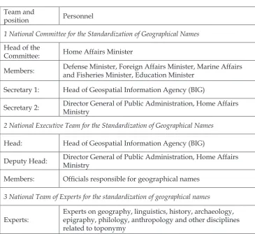
The collection of data for standardizing names in Indonesia is governed in Presidential Decree No. 112/2006 on the National Committee for the Standardization of Geographical Names. Three working teams are named: (1) the National Committee for the Standardization of Geographical Names having the most authority, and tasked with oversight and policy; (2) the National Executive Team for the Standardization of Geographical Names;
and (3) the National Team of Experts for the standardization of geographical names. The composition of these teams and their personnel is shown in Table 1.
Team and
position Personnel
1 National Committee for the Standardization of Geographical Names Head of the
Committee: Home Affairs Minister
Members: Defense Minister, Foreign Affairs Minister, Marine Affairs and Fisheries Minister, Education Minister
Secretary 1: Head of Geospatial Information Agency (BIG)
Secretary 2: Director General of Public Administration, Home Affairs Ministry
2 National Executive Team for the Standardization of Geographical Names Head: Head of Geospatial Information Agency (BIG)
Deputy Head: Director General of Public Administration, Home Affairs
Ministry
Members: Officials responsible for geographical names 3 National Team of Experts for the standardization of geographical names
Experts:
Experts on geography, linguistics, history, archaeology, epigraphy, philology, anthropology and other disciplines related to toponymy
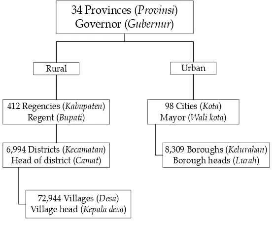
For the efficient administration of its work, human resources with the appropriate and adequate skills and knowledge are needed at all levels. Because name standardization is done nationwide, BIG’s activities for this must work within the existing administrative and bureaucratic structure. The country is divided into administrative areas of different sizes. The largest of these areas are the 34 provinces which are run by Governors. Below the provincial level, the administrative areas distinguish rural and urban areas. Cities are divided into boroughs. Meanwhile, provinces are divided into regencies, districts and villages. The management is hierarchical and distinguishes between rural and urban areas. This administrative structure is shown in Figure 1.
Apart from following national legislation, names standardization activities must also be reported to the ASE Division at division meetings. Beyond this, it reports through its division to UNGEGN. Figure 2 summarizes UNGEGN’s workings.
Indonesia’s name standardization activities must be in line with UNGEGN resolutions. Substantive resolutions on the subject of geographical names cover a range of associated topics, which link to the technical, economic, social and cultural benefits of national standardization. In general the resolutions provide guidelines and frameworks for national and regional activity and action, relating to:
• National names authorities • Terminology • Geographical names databases • Pronunciation • Gazetteers – paper and digital • Exonyms
• Training courses in toponymy • Toponymic guidelines
• Romanization systems • Features beyond a single sovereignty • Country names
If one takes into account both the complexity of the guidelines and tasks set out by UNGEGN, and also the sheer size of Indonesia and the complexity of its geography, being an archipelago, and also the huge diversity of its local languages and cultures, then the scale of the task of names standardization becomes apparent.
Figure 1. Administrative structure in Indonesia.
(UNGEGN 2012)
34 Provinces (Provinsi) Governor (Gubernur)
Rural Urban
412 Regencies (Kabupaten)
Regent (Bupati) Mayor (98 Cities (Wali kotaKota) )
6,994 Districts (Kecamatan)
Head of district (Camat) 8,309 Boroughs (Borough heads (KelurahanLurah) )
Standardizing names in the built environment
Another priority for the government is standardization of names for the man-made or built environment. This includes streets, dams, bridges, reservoirs, housing estates, schools and other buildings. In charge of this is the National Executive Team for the Standardization of Geographical Names, headed by the Head of Geospatial Information Agency (BIG) and assisted by the Director General of Public Administration at the Home Affairs Ministry. They coordinate with other agencies such as Regional government, other government bodies, the Indonesian Chamber of Commerce and Industry (KADIN), the Indonesian Young Entrepreneurs Association (HIPMI), the Association of Indonesian Real Estate Developers (REI), Advertising agencies and production houses (M. Lauder 2014a). These organizations are all important stakeholders as their work involves residential developments covering city, office, shopping mall, resort and other real estate services which all require place names. Work on this is scheduled to start in 2015.
Figure 2. Modus operandi of UNGEGN. UN Conferences on the Standardization
of Geographical Names (UNCSGN)
UN Secretariat (UN Statistics Division)
UN Group of Experts on Geographical Names
(UNGEGN) UNGEGN
Bureau
UN Liaison with Scientific Groups
Divisions
(24 Linguistic/Geographical Divisions)
Country Names
Toponymic Files and Data Gazetteers
Publicity and Funding
Toponymic Terminology
Romanization Systems
Evaluation and Implementation
Exonyms
Pronunciation
Geographical Names as Cultural Heritage
Task Team for Africa
Toponymic Guidelines Coordinator
Principles for geographical naming in Indonesia
Based on Home Affairs Minister Regulation No. 39/2008: Manual for the Standardization of Geographical Names; Chapter 3, Article 6. a number of principles have been established to guide the process of creating or standardizing geographical names. These take into consideration culture, history, religion, philosophy, politics and linguistics. The principles, which are widely agreed on, provide an external set of conditions that make it possible to justify decisions taken in geographical naming. Eight principles are described here.
Principle 1 Use the Roman script
In all human languages, three main kinds of script can be distinguished: alphabetic (Roman, Cyrillic, Arabic), syllabic (Japanese hiragana and katakana; Korean hangul) and ideographic (Chinese hanzi).
A number of different scripts are used in Indonesia. The Roman script is widely used, both for the Indonesian language and for English and some other foreign languages. The Arabic script is also widely used and well known due to its use in the Qur’an and relations with Arabic speaking countries. Indonesia has a number of large indigenous languages with a history of literacy and which possess their own scripts. These include Javanese, Balinese, and Batak. In languages like Javanese, the use of the traditional local script would have the advantage of capturing the pronunciation of words better than the Latin script. But the script is not well known beyond its own community. UNGEGN advises that the Roman script is used and also that it is used without additional distinguishing marks (diacritics). The use of the Roman script supports international communication.
Principle 2 Use one name per geographic feature
Confusion can arise if the same place name is used for more than one specific place. For example, Batavia is the historical name for Jakarta. However, we also find there is a Batavia in Argentina, and also in the USA, there are more Batavias in California, Illinois, Ohio and New York (Ormeling 2006b). In Indonesia, Surabaya is one of Indonesia’s main cities, on the island of Java. But you can also find Surabaya in Lampung province and in Bengkulu province. In normal everyday situations, people would not get these different places with the same name confused. But there is a potential for things to go wrong. This happens through a combination of lack of knowledge on the part of the person, assumptions about interpretation, and some pressure involved in emergency or stressful situations. When a person ends up in the wrong town by mistake it may be simply inconvenient, but when it involves aid supplies to a disaster area going to the wrong place, lives can be at stake.
Principle 3 Preserve local language names
ethno-linguistic groups and languages. These groups have lived where they are for hundreds or even thousands of years. Sometimes, they moved into the area after migrating from somewhere else. When a people no longer exists in a place, the names they gave earlier may remain as a record of the time when they still lived there. In other words, just as existing local names are a record of the past, so in today’s world, by giving local names, we are marking and commemorating our present existence so it can be known to those in the future. Conversely, if we do not use local names, but use the national language or a foreign language, we are effectively erasing our own existence. This appears to be a very popular thing to do, driven partly by the mistaken belief among business people and developers that a foreign name may have marketing value. An example of this is the choice of name for a cemetery located in Magakarya village, Teluk Jambi, Karawang, in West Java province. The cemetery is called San Diego Hills - Memorial Park and Funeral Homes. Local names are preferred for naming geographical features in order to preserve and respect the communities who live where those features are found.
Principle 4 Comply with government legislation
Topographic naming should should comply with all relevant legislation, national and international. This means that people who are working on the standardization of geographical names need to be aware of what the relevant prevailing laws are. Of particular importance is Presidential Decree Number 112 of 2006 on the National Team for the Standardization of Geographical Names. This decree starts by acknowledging that many place names, both for natural and man-made features in Indonesia do not yet have names, that those already with names need standardization, and that name standardization is needed urgently to guarantee the proper administration of Indonesian territory. The decree specifies what work needs to be done, why and by whom.
Principle 5 Respect the existence of ethnicity, religion, race, and class
Indonesia is extremely diverse with respect to ethnicity and language and we can also find differences of religion, class, and other social markers. Communities have complex identities and live in close contact with other communities. Other factors may be whether a community is in the majority or a minority. Indonesia, with this mix, has proven to be generally very harmonious. However, in order to avoid stoking sensitities, the Indonesian government takes steps to maintain this harmony and avoid upsetting one group or another.
In terms of naming of places, an important objective is to avoid giving offense, intentionally or otherwise through the choice of a name. Offense may be caused when a name through inference or other mechanisms of interpretation can be seen to belittle, ridicule or criticise. A properly functioning democracy is marked by the degree to which all citizens are equally respected.
communities and respecting them, the naming process can help to maintain and promote social harmony.
Principle 6 Do not use proper personal names of people who are still alive
It is possible to find examples of businesses or brands which are named after the person who founded them. Eponymous brands include sports shoe brand Adidas which is named after Adolph “Adi” Dassler; Gillette disposable razors, after King C. Gillette; and Jacuzzi, the hot tub, named after Candido Jacuzzi (Benjamin 2012). Despite the success of these brands and others, and the legacy that the name brings, new entrepreneurs are often ill advised to use their own name for a company as it ties their reputation to the fortunes of the product. There are also reasons why we should avoid naming places after people who are still alive. One is envy. For example if a street is named after a person still living there, some of their neighbours might disagree with the decision. Proper personal names of living people are not used for naming geographical features because doing so has the potential to exagerrate the individual’s importance, to make them into a cult figure, and to give them an unfair advantage in society. This is ultimately not beneficial for the healthy growth of democracy, human rights, and social equity. Meanwhile proper names of existing private or public organizations are not used for naming geographical features because the publicity has the potential to give that organization an unfair advantage over its competitors. However, this principle on proper names of people applies only to living people. Proper personal names may be used to name geographical features if the person has been dead for at least five years, and they have made a significant contribution to the state or the local community. Examples include: Jalan Sudirman (an arterial road in the heart of Jakarta named after a general who fought in Indonesia’s war of independence) and Bendungan Sutami (a dam named after a minister during Soekarno’s presidency) (M. Lauder 2014a).
Principle 7 Use Indonesian rather than foreign languages
The use of Indonesian or one of the regional languages is advised because this supports the intended functions of each, namely national unity and the preservation of and support for cultural diversity in Indonesia. An example is the town of Makassar in South Sulawesi. During the Suharto era, this local name was changed to one in Indonesian, Ujung Pandang. Recently, the name was changed back to its earlier name, Makassar, because this is part of the place’s history, culture and identity. The principle here is that you should use Indonesian or a regional language.
In the case of foreign words, it is possible to use them, as long as there is a historical or cultural value in doing so. For example, during the colonial period, the Dutch built as many as 459 forts all over Indonesia.5 The following
are notable examples, with location and the date they were built: (1) Fort Rotterdam, Ujung Pandang, 1545; (2) Fort Belgica, Banda Island, 1611; (3) Fort Vastenberg, Solo, 1745; and (4) Fort Du Bus, Papua, 1828.
Principle 8 Limit names to a maximum of three words
Names can be long or short and they can consist of one or more words. Some are memorable because they are so long. For example, the following 67 character name of a train station in North Wales, Great Britain: Gorsafawddach a’idraigodanheddogleddolonpenrhynareurdraeth-ceredigion, gets quoted a lot and provokes interest with potential tourists. People may go there partly because the name is so long. However, for daily life, shorter names are best. Most people would approve that the name Los Angeles is used for the US city rather than the 12 word version which it is abbreviated from: El Pueblo de Nuestra Senora la Reina de los Angeles de Porciuncula. The following examples are names from the Batak language found in South Tapanuli: Purbasinombamandalasena; Dali hannataluhutaraja; Hutalosungparandolok (Rais 2006). Short names have the advantage of making them easier to remember and they are far more practical in maps because they take up less space.
Other problems
There are a number of other problem classes of name. One of these is illustrated by the following example. In West Sumatera there is a village called 2 × 11 6 Lingkung. It is not clear what this means. But literally, the name is something like ‘two times eleven - six surroundings’ (Ayatrohaédi 2006). Names such as this may have novelty value, but they could easily cause problems as labels on maps and in communication because they don’t obviously conform to the linguistic structure of place names and because their meaning is opaque.
Field work and training
Data collection
Name standardization in Indonesia requires that primary data on names is collected from the field. This involves a number of steps which can be described briefly as follows:
• Step 1 involves obtaining basic information about the history, language and culture of the local community;
• Step 2 consists of doing field work to collect the geographical names used by the local community and attempting to identity the generic place names in the local language;
• Step 3 involves making accurate notes of place names, place name spellings and their pronunciations recorded from local language speaker informants; • Step 4 is the investigation of the origins of geographical names (etymology)
Essentially, this is a bottom-up process, with data originating in the field and moving up the hierarchy. A good deal of coordination and decision making is required for data collection. The head of the district (camat) or other administrative area should perform an inventory of geographical names in their area. The inventory of geographical names should cover all the geographical features whether they do not yet have names or already do. Where it is found that an existing name violates the principles for geographical naming, then a new name should be suggested by the senior government official there (village head, district head, or other official in charge) after taking into consideration the names submitted by the local community. The resulting inventory of names of geographical features should be delivered by the local government head to the District or City Committee.
The District or City Committee should conduct an inventory and review of the proposed standardization of the names of the topographic features submitted by all the villages (or other buroughs) in the region. The completed review should be reported to the Provincial Committee. The Provincial Committee should inventorize and review these submissions from the District or City level Committees in their area. These completed reviews should in turn be reported to the National Team. The National Team should review the names of geographical features suggested for standardization by the Provincial Committees.
The data collected in the field and the decision-making process by the national and regional teams is the basis for producing a standardized list of names which are recorded in the Gazetteer. The National Gazetteer of geographic names is the official list of geographical names in the country and is used as the main reference standard for names. The Gazetteer includes a list of (1) the names of all the islands and natural geographical features; (2) administrative areas; (3) man-made features. The Gazetteer includes not only the single standard name for a feature, but also all the variants which have been collected (M. Lauder 2014b).
The names in the Gazetteer are to be the authoritative and sole reference for use in society. This includes names in all official documents, the mass media, and school text books. Also, importantly, it is the main reference source for map editors. Maps provide various views of the natural and man-made environment on or below the earth’s surface. All government produced maps must use the standardized names from the Gazetteer because privately produced maps sometimes use official maps as an authority. Official maps are produced by BIG and they create a master map which is to be the sole basis for all other maps such as maps for mining, for tourism, for property development, or for natural disaster prediction. It is important that maps which are used as an important reference are reliable and standardized with reference to names and labels (M. Lauder 2014b).
Toponymic training
performing this from national down to local level have the appropriate knowledge and skills. To help develop these skills, UNGEGN has organized a series of international toponymic training courses for every division. For member countries in the Asia South-East & Pacific South-West Division, four training courses have been held so far in different places in Indonesia:
1. Cisarua, West Java, 1981 2. Cipanas, West Java, 1989 3. Malang, East Java, 2005
4. Yogyakarta, Yogyakarta Special Region in Java, 2012
These courses were supported by UNGEGN. The organizing committee was BIG. The trainers included senior figures in UNGEGN, and experts from Indonesia and around the world.
Apart from the UNGEGN led courses, BIG has also organized a number of seminars, workshops and coordination meetings with representatives from all provinces. They have worked in collaboration with the Ministry of Home Affairs, the Ministry of Maritime Affairs and Fisheries, the Directorate of Topography of the Indonesian Army and the Hydro-Oceanographic Office of the Indonesian Navy.
In the future, the national Agency for the Development of Language of the Ministry of Education and Culture should be more involved and better able to contribute than at present because geographical names are a linguistic phenomenon and because the authority for regulations on language issues lies with this agency.
A linguistic perspective on place names
The article so far has looked at place names from the perspective of international and national administration, with the focus on UNGEGN, and Indonesia’s National Executive Team for the Standardization of Geographical Names. The following section, looks at place names from the perspective of the National Team of Experts for the standardization of geographical names, which is basically an academic or scientific perspective.
Another important study – of place names in ancient Javanese inscriptions – is the monumental onomastics directory of Javanese epigraphy by Frenchman Louis-Charles Damais. This systematically presents in its 1025 pages the findings of a study that took about 11 years (1955-1966) on anthroponyms and toponyms for geographical features, building names or administrative areas (Damais 1970). However, few Indonesian linguists know about toponymy and there is not yet a national society or community of scholars who share an interest in the subject.
Generic name elements
It is common for toponyms to consist of two elements, a generic one and a specific one.
• Generic terms are common nouns that describe a topographic feature in terms of its characteristics and not by its proper name. Examples are: mount, gunung, sea or laut. If a generic term forms part of a toponym, it is called a generic element.
• Generic elements are the part of a toponym which consists of a generic term. The generic element does not necessarily indicate the type or class of feature of the item named. It can be in Indonesian or in a regional language. For example, Jalan is the generic element in the toponym Jalan Sudirman. • A specific element is the part of a toponym that does not constitute a generic term and that distinguishes it from others of the same feature class. For example, Merapi is the specific element in the toponym Mount Merapi.
Generic elements in place names are needed to cover a variety of places. These would include:
• Natural areas: mountains, hills, valleys, seas, islands, straits, estuaries, bays, forests.
• Administrative areas: province, district, sub-district, village.
• Man-made areas: residential areas, shopping area, roads, highways, dams, airports, ports, hospitals, schools (M. Lauder 2014a).
generic place terms. In Table 2 below, data from just ten of the 1,500 villages is presented. The table shows the place name data in the local languages for three generic place terms: mountain (gunung), river (sungai), and bay (teluk).
N Language Gunung Sungai Teluk Village Regency Province
1 Aceh gunong krung teluk Blangcut Banda
Aceh Aceh
2 Muduk dohik sungi toluwak Empodis Sanggau Kalimantan Barat
3 Mamuju tanete lelo‘ lemba Binanga Mamuju Sulawesi Selatan
4 Hualu ulay wayam
loeloha-yam Hualu
Maluku
Tengah Maluku
5 Bedoanas itar wanatu orombasi Andamata Fak Fak Papua
6 Wejewa letena loko manosika
Kalembu Ndra Mane
Sumba Barat
Nusa Tenggara Timur
7 Sasak doro sori teluk Nungga Bima
Nusa Tenggara Barat
8 Bali bukit tokad lolowan Klumpu Klungkung Bali
9 Melayu Betawi gunung sungay tilu‘ Pulau
Panggang
Jakarta Utara
Jakarta, DKI
10 Sunda gunung wahangan supitan Sukamju Sukabumi Jawa Barat
As data on generic place names from local languages is needed, research that investigates as many of these languages as possible is recommended. The research should be designed specifically to cover all languages in every province. It should use a consistent methodology that could gather information on generic terms and place names, along with rich descriptive information about their meaning and history in the culture of the people.
Exonyms
An exonym can be thought of as the name for a country or place outside your own. UNGEGN defines an exonym as a “Name used in a specific language for a geographical feature situated outside the area where that language has official status, and differing in its form from the name used in the official
language or languages of the area where the geographical feature is situated”.6 In general, exonyms only are formed for names of countries, capital cities, and sometimes large rivers. Examples of exonyms are: (1) Warsaw which is the English exonym for Polish Warszawa; (2) Londres which is French for London; and (3) Mailand which is German for Italian Milano. The former name in English for the Chinese capital, Peking, is an exonym. However, neither the officially romanized endonym Moskva for Москва is an exonym, nor the Pinyin form Beijing (UNGEGN 2002).
Table 3 shows the exonyms of three European place names: (1) Wien, the capital of Austria; (2) Venezia, a city in Italy; and (3) Norge, the Scandanavian country. Exonyms for these are given for seven European languages, English, German, French, Hungarian, Spanish, Dutch, and Polish.
Language Wien (German) Venezia (Italian) Norge (Norwegian)
1 English Vienna Venice Norway
2 German Wien Venedig Norwegen
3 French Vienne Venise Norvège
4 Hungarian Bécs Velence Norvegia
5 Spanish Viena Venecia Noruega
6 Dutch Wenen Venetië Noorwegen
7 Polish Wieden Wenecja Norwegia
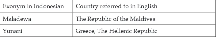
Table 4 shows the exonyms of country names in Indonesian, along with the country’s formal name in English.
Exonym in Indonesian Country referred to in English
Aljazair Algeria, People‘s Democratic Republic of Algeria
Belanda The Netherlands
Hongaria Hungary
Inggris The United Kingdom
Jepang Japan
6 See Definition of exonym applied by the Commission on Standardization of Geographical Names (http://ungegn.zrc-sazu.si/Portals/7/WGE%20Activities/Prague_2007/ Poland_Zych_Definition_of_ exonym.pdf).
Exonym in Indonesian Country referred to in English Maladewa The Republic of the Maldives Yunani Greece, The Hellenic Republic
The use of Inggris as the name for the The United Kingdom of Great Britain and
Northern Ireland (U.K.) strikes many British people as naïve and awkward, and many have wondered whether a more appropriate name could be chosen. Inggris is an unfortunate choice because the U.K. is a union of four countries: England, Scotland, Wales and Northern Ireland. Inggris obviously is a phonological adaptation of England. So, to a U.K. citizen, calling the U.K.
Inggris is the same as if in the U.K. people called the Republic of Indonesia Java. Exonyms are problematical in a number of ways, not the least of which is the problem of defining what an exonym is. This is because there are a number of features that are not mentioned in UNGEGN’s definition but which can cause a name to not be an exonym. For example, a place name where diacritical marks are lacking is not an exonym; and nor is one where case endings are lacking or have been added; a name whose generic parts have been translated has an unclear status.
Secondly, exonyms are a problem because the different variants can make communication difficult. Take the place name Monaco. Most of us know it as being on the Riviera. But in Italian it is the exonym for Munich. The following news story illustrates this.
Two women led themselves on a wild goose chase from Italy to Munich after arranging to meet their niece in Monaco - which in Italian can mean either the tiny principality on the French Riviera, or Bavaria’s capital. “The problem was they thought Munich was Monaco,” said a spokesman for Munich police on Wednesday. Called Monaco di Baviera in Italian, the city is known as Muenchen in High German, Mnichov in Czech, Monachium in Polish and Minga in the local
Bavarian dialect. The two women, originally from the Dominican Republic, had driven across the Alps from Trento in northern Italy to collect the 14-year-old from the Paris-Munich train, but started to panic and went to the police when
the girl failed to appear. As the two spoke only Italian and Spanish, and because the niece had no mobile phone, it took police 1½ hours to establish that she had actually gone to the Mediterranean. Afterwards, the women got back in their car and set off on the 840 km (523 mile) journey to Monaco, the spokesman said. (Reuters 20087 – emphasis added).
The situation in Indonesia at present is that while exonyms exist for most places, the spelling of these exonyms has not been standardized. Exonyms
7 Source: Dave Graham (2008), “Munich’s Italian name diverts tourists from Monaco”, Reuters, Berlin Wed Apr 9, 2008 (http://www.reuters.com/article/2008/04/09/us-germany-munich-idUSL0972024920080409).
need the attention of linguists to standardize their spelling and pronunciation so that they can be entered into the National Gazetteer.
Etymologies of place names
The etymology of toponyms is the study of the sources from which the names have been derived and the process of their creation. The great majority of place names are not arbitrary in origin, but usually refer to some attribute of the place denoted or of its inhabitants or rulers (Durkin 2009: 268).
In particular, place name etymology focuses on what language the place name was coined in, and whether the names originate from other place names, from personal names, from the commemoration of events, or descriptions of the geographical or social aspects of the place, or have some other origin (McArthur 1992: 1048).
Some examples of country names illustrate the varieties of processes involved. (1) Argentina comes from Spanish meaning ‘the silver republic’; (2) The Canary Islands, also the Canaries, comes from the Latin for ‘dog’ and has nothing to do with birds; and (3) Pakistan is actually an acronym – P(unjab) + A(fghan tribes) +K(ashmir) + S(ind) +(Baluchis)tan (Crystal 1997: 115).
In Indonesia, there have been few studies of place name etymologies. However, the following three examples of place names in Jakarta have an etymological dimension. They reveal the traces of the expansion of the Mataram kingdom outside its main area of power (M. Lauder and A. Lauder 2014).
Matraman is a small sub-district in East Jakarta. This unassuming place conceals in its name an interesting history. Matraman was the location of the Mataram troops final defense in the campaign against Batavia (Ruchiat 2011: 113–115). The place name here is a phonological adaptation of the kingdom name.
Pegangsaan sub-district in Central Jakarta was formerly a handicraft
center for fine metal workers in bronze (gangsa) (Ruchiat 2011: 123). Many of the artisans came from Mataram in Java. The name here originates from the material used in their work by these people who had migrated to the place from Mataram.
Jagakarsa sub-district, South Jakarta originated from a general called Raden Bagus Jagakarsa Surobinangun during the Mataram war of 1625. After his defeat against Batavia, he decided not to return to Mataram, fearing that he might be beheaded (Zaenuddin 2012: 257–258). Here, the place name is based on the name of a person.
etymology can contribute significantly to our knowledge of Indonesia’s past. Hopefully, more linguists will turn their attention to this.
Orthography development for toponymy
One of the main tasks of toponymy is to record place names in writing. In Indonesia, however, a majority of the languages are oral and do not yet have their own writing system. In order to write place names for these languages, a writing system must be developed for them by linguists. This work is not only beneficial to place name standardization, but also is seen by many researchers as a pre-requisite to many of the activities in revitalization and documentation programs for languages which are in danger of disappearing due to diminishing numbers of speakers. The development of an orthography or writing system is a complex task that cannot be based solely on linguistic decisions. It requires consideration of historical, religious, cultural, identity-related and practical factors. In multilingual endangered language communities, it is necessary to understand not only the endangered language and those it is in contact with, but also how these interact (Lüpke 2011: 312-314).
In addition to linguistic factors, it is also necessary to consider the psycholinguistic and sociolinguistic dimensions of emergent literacy through the development of an orthography (Coulmas 2003). The psycholinguistic elements of reading and writing in bilinguals is far more complex than in monolinguals (Bialystok 2001). The development and introduction of orthographies also has a social dimension. As such, it is best approached from an ecolinguistic perspective (Fill and Mühlhäusler 2001). An ecological perspective on the introduction of written language considers that writing is just one of many different registers available to the community and that it may be used not just for conveying information but in connection with varied functions that mark social, religious, historical and linguistic identity (Lüpke 2011: 335).
There are a number basic considerations for orthographic design: (1) Technological usability: Are the symbols/graphemes readily available on a standard local keyboard/typewriter? (2) Social and cultural acceptability: Does the language community and/or the Ministry of Education approve the orthography? (3) Psycholinguistic acceptability: Should the orthography represent all phonemes? Should the spelling show some/all/ no morphophonemic variations? (4) Function of the orthography: Will the orthography be used in schools? Does the orthography facilitate treading and/or writing? Should the orthography privilege first or second language learners? (Guérin 2008). In Indonesia, any new orthography should also take into consideration the high degree of multilingualism in the country.
being developed for Indonesia’s oral languages. Using the Roman script means that once the speakers of that language have developed literacy in it, they do not need to learn a new script for any further languages, whether Indonesian or foreign. This lessens the burden of literacy development.
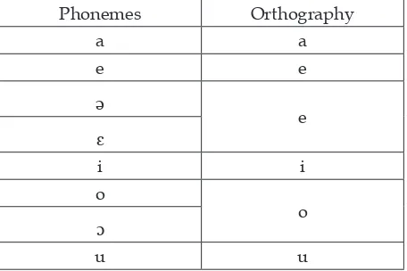
Apart from the diversity of languages in Indonesia, many of these languages have dialects. One of the problems in developing an orthography for such languages is how to deal with this multi-dialectal situation. On the one hand, the dialects form a unity as a single language. On the other, the dialectal differences in pronunciation or vocabulary are part of the people’s identity. A good orthography needs to strike the right balance in capturing enough of the detail while not making the orthography too complex. An example of this comes from a practical orthography that was established for five Sasak dialects spoken on Lombok island. The orthography represents only those vowels that are contrastive in all of the dialects. The disadvantage of this orthography is that it creates ambiguity through homographs in individual dialects. It does, however, have the great advantage offering a unified orthography for all dialect groups (Seifart 2006: 294). Table 5 shows the correspondence between the phonemes and the orthography. In this version, there is not a one to one correspondence between sounds (phonemes) and letters (orthographs) for all sounds. So, while the sound [a] is always written with the letter ‘a’ and this letter is not used for other sounds, the letter ‘e’ is used to represent three different sounds: [e], [ə], and [ɛ].
Phonemes Orthography
a a
e e
ə
e
ɛ
i i
o
o
ɔ
u u
The development of orthographies require the expertise of a linguist who has a knowledge of phonetics, phonology, morphophonemics and also other disciplines including bilingualism, multilingualism, psycholinguistics, sociolinguistics, ecolinguistics, language change and field linguistics.
Current toponymic research at Universitas Indonesia (UI)
At the time of writing, two postgradute students in the Faculty of the Humanities at UI are working on toponymic-focused research for their
degrees. One is a doctoral and the other a masters student.
The doctoral student has a background in archeology and is demonstrating how toponyms can help to define the location of the ancient Mataram kingdom in Yogyakarta and central Java. The toponymic data for this study comes from village names found in old manuscripts and on stone inscriptions.
The masters student is performing an etymological study of train station names in the greater Jakarta conurbation area, known as Jabodetabek, an acronym for Jakarta-Bogor-Depok-Tangerang-Bekasi. The data for this comes from the station names and historical references to them.
Conclusion
This paper has provided an overview of two dimensions of geographical names standardization efforts in Indonesia. Although toponymy is not widely known, the value of place names, this article argues, has been underappreciated. Place names do have value, both in a practical sense, as a necessary and pervasive aspect of social functioning in a globalized world. In cases of territorial integrity, or the efficient functioning of government administrations, they can play a fundamental role which affects very important outcomes. They also have value as an object of academic study, from a range of perspectives including linguistics, philosophy, history, geography and archeology.
Place names need standardized to facilitate efficient administration of a wide range of functions in society. Beyond that, place names in Indonesia, of islands, have a significance in relation to questions of territorial sovereignty. Because the management of islands is an important factor in the adjudication of territorial disputes, Indonesia has recently begun to take seriously the need to inventorize and demonstrate good management of its islands, in particular the outer islands which might be the subject of claims by other nations.
The responsibility for this lies primarily with BIG but a number of other government and military agencies are involved. The work has been taken seriously and much has been achieved. However, the scale of the task is huge and the work needs to be part of the global level of standardization under the auspices of UNGEGN at the United Nations. Currently, Indonesia is working with UNGEGN to ensure that its standardization activities are in line with international conventions.
What is needed in future is to improve human resources at all levels. To achieve this, adequate training needs to be carried out to ensure that the people in the provinces understand the historical, linguistic, geographic, cultural and other aspects of the work. A major goal is to complete the work on the national gazetteer and on the master map – known as the one map policy – which can form the basis for all other maps.
place names, data that can help with the standardization of exonyms, and of generic place terms.
Future efforts will require the continued support of experts in range of disciplines including linguistics, etymology, philology, epigraphy, history, archeology, geography and culture. If this can be done, Indonesia will be moving in the right direction.
References
Ali, Lukman; Hasan Alwi; Harimurti Kridalaksana; and Tim Penyusunan Kamus (eds). 1991. Kamus Besar Bahasa Indonesia. Second edition. Jakarta: Pusat Bahasa, Departemen Pendidikan Nasional. [First edition: Anton Moeliono and Tim Penyusunan Kamus, Jakarta: Balai Pustaka, 1988.] Ayatrohaédi. 2006. “Languages and Generic Names in Geographical Names
and Linguistic Aspects on Toponymy in Indonesia”, in: Jacub Rais, Widodo Edy Santoso, and Titiek Suparwati (eds), Proceedings of the United Nations Group of Experts on Geographical Names; Training Course on Toponymy, 11-23 September 2005, Batu, Malang, Indonesia, pp. 37-38. Cibinong, Indonesia: National Coordination Agency for Surveys and Mapping (Bakosurtanal). Benjamin, Kathy. 2012. “11 Eponymous Brands and the People Behind Them.
Mental Floss”. [Http://mentalfloss.com/article/30655/11-eponymous-brands-and-people-behind-them; accessed on 8-12-2014.]
Bialystok, Ellen. 2001. Bilingualism in development; Language, literacy, and cognition. Cambridge: Cambridge University Press.
Bright, William. 2003. “What IS a name? Reflections on onomastics”, Language and Linguistics 4(4): 669-681.
Carey, Peter. 2014. “The uses and abuses of history; A British historian’s view of Indonesia”. [Inaugural Lecture as Adjunct Professor at the Faculty of the Humanities, Universitas Indonesia, 1 December, Faculty of Humanities, Universitas Indonesia.]
Coulmas, F. 2003. Writing systems; An introduction to their linguistic analysis. Cambridge: Cambridge University Press.
Crystal, David. 1997. The Cambridge Encyclopedia of Language. Second edition. Cambridge: Cambridge University Press.
Damais, Louis-Charles. 1970. Répertoire onomastique de l’épigraphie Javanaise (jusqu’à pu sindok ‘Sri Isanawikrama Dharmmotungadewa); Étude d’épigraphie indonésienne. Paris: École française d’Extrême-Orient.
Durkin, Philip. 2009. “The etymology of names”, in: Philip Durkin, The Oxford Guide to Etymology, pp. 266-283. Oxford: Oxford University Press.
Fill, Alwin and Peter Mühlhäusler (eds). 2001. The ecolinguistics reader; Language, ecology and environment. London / New York: Continuum. Guérin, Valérie. 2008. “Writing an endangered language”, Language
Documentation and Conservation 2(1): 47–67.
Kadmon, Naftali. 2000. Toponymy; The lore, laws, and language of geographical names. New York: Vantage Press.
heritage in Indonesia”. [Paper, Place Names Preserving Cultural Heritage, Brunei, 13-14 May; United Nations Group of Experts on Geographical Names (UNGEGN) Asia, South-East Division.]
Lauder, Multamia R.M.T. 2014a. “Penerapan undang-undang terhadap pembakuan nama rupabumi secara nasional dan bertahap”. [Paper, Rapat Koordinasi Nasional Penguatan Kapasitas Pemerintah Daerah dalam Pembakuan Nama Rupabumi, Jakarta, 21 Agustus; Badan Informasi Geospasial (BIG), Indonesia.]
Lauder, Multamia R.M.T. 2014b. “Memahami manfaat toponimi bagi jatidiri bangsa. [Paper, Rapat Pendampingan Dekonsentrasi Pembinaan & Pembakuan Nama Rupabumi Unsur Alami, Jakarta, 20 Maret; Badan Informasi Geospasial (BIG), Indonesia.]
Lauder, Multamia R.M.T. and Allan F. Lauder. 2014. “A historical perspective on the study of geographical names in Indonesia”. [Paper, The International Symposium on Toponymy; Geographical Names as Cultural Heritage, 5-7 November, Seoul, Korea; Korean National Geographic Information Institute (NGII).]
Lüpke, Friederike. 2011. “Orthography development”, in: Peter K. Austin and Julia Sallabank (eds), The Cambridge Handbook of Endangered Languages, pp. 312-336. Cambridge: Cambridge University Press.
McArthur, Tom (ed.). 1992. The Oxford Companion to the English Language. Oxford: Oxford University Press.
Ormeling, Ferjan. 2006a. “Endonyms versus exonyms”, in: Jacub Rais, Widodo Edy Santoso, and Titiek Suparwati (eds), Proceedings of the United Nations Group of Experts on Geographical Names; Training Course on Toponymy, 11-23 September 2005, Batu, Malang, Indonesia, pp. 94-100. Cibinong, Indonesia: National Coordination Agency for Surveys and Mapping (Bakosurtanal). Ormeling, Ferjan. 2006b. “Standardization of geographical names”, in: Jacub
Rais, Widodo Edy Santoso, and Titiek Suparwati (eds), Proceedings of the United Nations Group of Experts on Geographical Names; Training Course on Toponymy, 11-23 September 2005, Batu, Malang, Indonesia, pp. 17-20. Cibinong, Indonesia: National Coordination Agency for Surveys and Mapping (Bakosurtanal).
Phillips, Keri. 2013. Is this a rock or an island? The tiny differences that could define a region. Ultimo, New South Wales: Australian Broadcasting Corporation (ABC). [Http://www.abc.net.au/radionational/programs/ rearvision/5145092; accessed on 4-12-2014.]
Rais, Jacub. 2006. “National standardization of geographical names in Indonesia”, in: Jacub Rais, Widodo Edy Santoso, and Titiek Suparwati (eds), Proceedings of the United Nations Group of Experts on Geographical Names; Training Course on Toponymy, 11-23 September 2005, Batu, Malang, Indonesia, pp. 21-23. Cibinong, Indonesia: National Coordination Agency for Surveys and Mapping (Bakosurtanal).
Edy Santoso. 2008. Toponimi Indonesia; Sejarah budaya yang panjang dari permukiman manusia dan tertib administrasi. Jakarta: Pradya Paramita. Ruchiat, Rachmat. 2011. Asal-usul nama tempat di Jakarta [Origins of place names
in Jakarta]. Jakarta: Masup.
Schnitger, Frederic Martin. 1936. Hindoe-oudheden aan de Batang Hari [Hindu antiquities at Batang Hari]. Leiden: Brill.
Seifart, Frank. 2006. “Orthography development”, in: Jost Gippert, Nikolaus P. Himmelmann and Ulrike Mosel (eds), Essentials of language documentation, pp. 275-300. The Hague: Mouton de Gruyter.
Taib, Abdul Kadir bin. 2012. “Proposal to split Asia South-East and Pacific South-West Division into Asia South-East Division and Pacific South-West Division”, UNGEGN Twenty-seventh session 30 July and 10 August 2012, New York; Working Paper No. 2. New York: United Nations Group of Experts on Geographical Names (UNGEGN).
Tiangco, Peter N. 2014. “Report of the Asia South-East (ASE) Division”,
UNGEGN Twenty-eight session 28 April–2 May 2014; Working Paper No. 69/4. New York: United Nations Group of Experts on Geographical Names (UNGEGN).
UNCLOS. 1982. United Nations Convention on the Law of the Sea (UNCLOS) of 10 December 1982. New York: United Nations Division for Ocean Affairs
and the Law of the Sea. [Http://www.un.org/depts/los/convention_ agreements/texts/unclos/UNCLOS-TOC.htm.]
UNGEGN. 2001. Consistent Use of Place Names; Brochure 00-77927. New York: United Nations. Groups of Experts on Geographical Names. [Https://unstats.un.org/unsd/geoinfo/UNGEGN/docs/pubs/ UNGEGNbrochure_en.pdf.]
UNGEGN. 2002. Glossary of Terms for the Standardization of Geographical Names. New York: United Nations Group of Experts on Geographical Names. UNGEGN. 2012. UNGEGN Media Kit. New York: United Nations Group of
Experts on Geographical Names. [Http://unstats.un.org/unsd/geoinfo/ UNGEGN/mediakit. html; accessed on 26-11-2014.]
UNGEGN. 2014. United Nations Group of Experts on Geographical Names. New York: United Nations Group of Experts on Geographical Names. [Http:// unstats.un.org/unsd/ geoinfo/UNGEGN/; accessed on 26-11- 2014.] Zaenuddin, H. M. 2012. 212 Asal-usul Djakarta Tempo Doeloe; Disertai fakta,
About the authors
Allan F. Lauder is a guest lecturer in the Post Graduate Linguistics Department program at the Humanities Faculty of the University of Indonesia (UI) where he teaches courses in Psycholinguistics, Corpus Linguistics, and Research Methods in Linguistics
for PhD students. He obtained his MA in the English Language at the Department of
English Language and Literature, National University of Singapore (NUS), Singapore,
1988 – 1990 and his Doctorate Degree in Applied Linguistics, English Language at Atma
Jaya University, Jakarta. His dissertation used corpus methods to investigate the news agenda and representation in an English language daily paper in Indonesia. His interests in linguistics focus largely on Psycholinguistics and Corpus Linguistics. He has also written on a range of subjects including the study of the indigenous regional languages
of Indonesia, language variation and change, geo-linguistics, language loss and language
maintenance, and language rights and language diversity. He is currently supervising theses on speech production and lexical access in Indonesian using an experimental Tip of the Tongue paradigm, and another using corpus linguistics methods to perform an
analysis of a corpus of novels by N.H. Dhini with a focus on gender issues.
Multamia R.M.T Lauder is a professor in the Linguistics Department program at the Humanities Faculty of the University of Indonesia where she teaches a variety of courses including Language Change, Method of Research in Linguistics, Language Variation,
Dialectology and Sociolinguistics. She obtained her Maîtrise de Linguistique et Phonétique from L’institut de Phonetique de Grenoble, France, 1980; Diplôme d’Études Approfondies de Géo-Linguistique (DEA) from Faculte des Lettres L’universite de Grenoble III, in France, 1981; and her Doctor of Linguistics (Cum Laude) in Dialectology, from the Literature
and Linguistics Study Program, Postgraduate Faculty, Universitas Indonesia, Jakarta, Indonesia, 1989. She was appointed as Professor in Geographical Linguistics at UI in 2003. She has held a variety of senior administrative positions in the faculty and in the
university’s central administration, most recently being the university’s Director of Education, a position she held for seven years until December 2014. Her interests focus