Jour nal of The oretical a nd Applied Information Tec hnology
© 2005 - 2015 JATIT & LLS. All rights reserved
ISSN: 1992-8645 www.jatit.org E-ISSN: 1817-3195
JOURNAL OF THEORETICAL AND APPLIED
INFORMATION TECHNOLOGY
EDITORIAL COMMITTEE
NIAZ AHMAD
(Chief Editor)
Professor, FCE, MOE, H-9 Islamabad
PAKISTAN
SHAHBAZ GHAYYUR
(Co- Chief Editor)
Assistant Professor, DCS, FBAS, International Islamic University Islamabad,
PAKISTAN
SAEED ULLAH
(Associate Editor)
Assistant Professor, DCS, Federal Urdu University of Arts, Science & Technology Islamabad,
PAKSITAN
MADIHA AZEEM
(Associate Editor)
Journal of Theoretical and Applied Information Technology, Islamabad.
PAKISTAN
SALEHA SAMAR
(Managing Editor)
Journal of Theoretical and Applied Information Technology, Islamabad.
PAKISTAN
KAREEM ULLAH
(Managing Editor)
Journal of Theoretical and Applied Information Technology, Islamabad.
PAKISTAN
SHAHZAD A. KHAN
Lecturer IMCB, FDE Islamabad, PAKISTAN
(Managing Editor/Linguists & In-charge Publishing)
Journal of Theoretical and Applied Information Technology, Islamabad.
PAKISTAN
October 2015. Vol. 80 No.3 .
i
Jour nal of The oretical a nd Applied Information Tec hnology
© 2005 - 2015 JATIT & LLS. All rights reserved
ISSN: 1992-8645 www.jatit.org E-ISSN: 1817-3195
JOURNAL OF THEORETICAL AND APPLIED
INFORMATION TECHNOLOGY
REGIONAL ADVISORY PANEL
Dr. SIKANDAR HAYAT KHIYAL
Professor &Chairman DCS& DSE, Fatima Jinnah Women University, Rawalpindi, PAKISTAN
Dr. MUHAMMAD SHER
Professor &Chairman DCS, FBAS, International Islamic University Islamabad, PAKISTAN
Dr. ABDUL AZIZ
Professor of Computer Science, University of Central Punjab, PAKISTAN
Dr. M. UMER KHAN
Asst. Professor Department of Mechatronics, Air University Islamabad, PAKISTAN
Dr. KHALID HUSSAIN USMANI
Asst. Professor Department of Computer Science, Arid Agriculture University,
Rawalpindi, PAKISTAN
October 2015. Vol. 80 No.3
.
ii
Jour nal of The oretical a nd Applied Information Tec hnology
© 2005 - 2015 JATIT & LLS. All rights reserved
ISSN: 1992-8645 www.jatit.org E-ISSN: 1817-3195
JOURNAL OF THEORETICAL AND APPLIED
INFORMATION TECHNOLOGY
EDITORIAL ADVISORY BOARD
October 2015. Vol. 80 No.3
.
iii Dr. CHRISTEL BAIER
Technical University Dresden, GERMANY
Dr KHAIRUDDIN BIN OMAR UniversitiKebangsaanMalysia, 43600 Bangi
Selangor Darul-Ehsan, MALYSIA
Dr. YUSUF PISAN
University of Technology, Sydney, AUSTRALIA
Dr. S. KARTHIKEYAN Department of Electronics and Computer Engineering, Caledonian College of Engineering,
OMAN (University College with Glascow University, Scotland, UK) DR. YUXIN MAO
School Of Computer & Information Engineering Zhejiang Gongshang University, CHINA
Dr. ZARINA SHUKUR
FakultiTeknologidanSainsMaklumat, University Kebangsaan MALYSIA
Dr. NOR AZAN MAT ZIN
Faculty of Information Science & Technology, National University of MALYSIA
Dr. R.PONALAGUSAMY
National Institute of Technology, Tiruchirappalli, Tamil Nadu, INDIA
Dr. MOHAMMAD TENGKU SEMBOK Universiti Kebangsaan MALYSIA
Dr. PRABHAT K. MAHANTI University of New Brunswick, Saint John, New
Brunswick, CANADA
Dr. NITIN UPADHYAY
Birla Institute of Technology and Science (BITS), Pilani-Goa Campus, INDIA
Dr. S.S.RIAZ AHAMED
Mohamed Sathak Engineering College, Kilakarai, &Sathak Institute of Technology, Ramanathapuram , Tamilnadu, INDIA
Dr. A. SERMET ANAGÜN
Eskisehir Osmangazi University, Industrial Engineering Department, Bademlik Campus,
26030 Eskisehir, TURKEY.
Dr. YACINE LAFIFI
Department of Computer Science, University of Guelma, BP 401, Guelma 24000, ALGERIA.
Dr. CHRISTOS GRECOS
School Of Computing, Engineering And Physical Sciences University Of Central Lancashire.
UNITED KINGDOM
Dr. JAYANTHI RANJAN Institute of Management Technology Raj Nagar, Ghaziabad, Uttar Pradesh, INDIA
Dr. ADEL M. ALIMI
National Engineering School of Sfax (ENIS), University of SFAX, TUNISIA
Dr. RAKESH DUBE
Professor & Head, RKG Institute of Technology, Ghaziabad, UP, INDIA
Dr. ADEL MERABET
Department of Electrical & Computer Engineering, Dalhousie University, Halifax,
CANADA
Dr. HEMRAJ SAINI
CE&IT Department, Higher Institute of Electronics, BaniWalid. LIBYA
Jour nal of The oretical a nd Applied Information Tec hnology
© 2005 - 2015 JATIT & LLS. All rights reserved
ISSN: 1992-8645 www.jatit.org E-ISSN: 1817-3195 October 2015. Vol. 80 No.3
.
iv Dr. SEIFEDINE KADRY
Lebanese International University, LEBONON
Dr. AIJUAN DONG Department of Computer Science Hood College Frederick, MD 21701. USA
Dr. ZURIATI AHMAD ZUKARNAIN University Putra Malaysia,
MALAYSIA
Dr. HEMRAJ SAINI
Higher Institute of Electronic, BaniWalid LIBYA
Dr. CHELLALI BENACHAIBA University of Bechar, ALGERIA
Dr. MOHD NAZRI ISMAIL
University of Kuala Lumpur (UniKL) MALYSIA
Dr. VITUS SAI WA LAM The University of Hong Kong, CHINA
Dr. WITCHA CHIMPHLEE SuanDusitRajabhat University, Bangkok,
THAILAND
Dr. SIDDHIVINAYAK KULKARNI University of Ballarat, Ballarat,
AUSTRALIA
Dr. S. KARTHIKEYAN Caledonian College of Engineering,
OMAN
Dr. DRAGAN R. MILIVOJEVIĆ
Mining and Metallurgy Institute BorZelenibulevar 35, 19210 Bor, SERBIA
Dr. E. SREENIVASA REDDY Principal - VasireddyVenkatadri Institute of
Technology, Guntur, A.P., INDIA
Dr OUSMANE THIARE Gaston Berger University, Department of Computer Science, UFR S.A.T, BP 234 Saint-
Louis SENEGAL
Dr. SANTOSH DHONDOPANT KHAMITKAR RamanandTeerthMarathwada University, Nanded.
Maharashtra 431605, INDIA
Dr. M. IQBAL SARIPAN
(MIEEE, MInstP, Member IAENG, GradBEM) Dept. of Computer and Communication Systems Engineering, Faculty of Engineering, Universiti
Putra MALAYSIA
Dr. E. SREENIVASA REDDY Principal - VasireddyVenkatadri Institute of
Technology, Guntur, A.P., INDIA
Dr. T.C.MANJUNATH, Professor & Head of the Dept., Electronicis& Communication Engg. Dept,
New Horizon College of Engg., Bangalore-560087, Karnataka, INDIA.
Dr. SIDDHIVINAYAK KULKARNI
Graduate School of Information Technology and Mathematics University of Ballart AUSTRALIA
Dr. SIKANDAR HAYAT KHIYAL Professor & Chairman DCS& DSE, Fatima
Jinnah Women University, Rawalpindi,
PAKISTAN
Dr. MUHAMMAD SHER Professor & Chairman DCS, FBAS, International Islamic University Islamabad,
PAKISTAN
Dr. ABDUL AZIZ
Professor of Computer Science, University of Central Punjab, PAKISTAN
Dr. M. UMER KHAN
Jour nal of The oretical a nd Applied Information Tec hnology
© 2005 - 2015 JATIT & LLS. All rights reserved
ISSN: 1992-8645 www.jatit.org E-ISSN: 1817-3195
Elite Panel Members Have A Decision Weight Equivalent of Two Referees (Internal OR External). The Expertise Of Editorial Board Members Are Also Called In For Settling Refereed Conflict About
October 2015. Vol. 80 No.3
Acceptance/Rejection And Their Opinion Is Considered As Final.
.
v Dr. RIKTESH SRIVASTAVA
Assistant Professor, Information Systems Skyline University College P O Box 1797, Sharjah, UAE
Dr. BONNY BANERJEE
PhD in Computer Science and Engineering, The Ohio State University, Columbus, OH, USA
Senior Scientist Audigence, FL, USA
PROFESSOR NICKOLAS S. SAPIDIS DME, University of Western Macedonia
Kozani GR-50100, GREECE.
Dr. NAZRI BIN MOHD NAWI Software Engineering Department, Faculty of
Science Computer Information Technology,
Universiti Tun Hussein Onn MALAYSIA
Dr. JOHN BABALOLA OLADOSU Ladoke Akintola University of Technology,
Ogbomoso, NIGERIA
Dr. ABDELLAH IDRISSI
Department of Computer Science, Faculty of Science, Mohammed V University - Agdal,
Rabat, MOROCCO
Dr. AMIT CHAUDHRY
University Institute of Engineering and Technology, Panjab University, Sector-25,
Chandigarh, INDIA
Dr. ASHRAF IMAM
Aligarh Muslim University, Aligarh-INDIA
Dr. MOHAMMED ALI HUSSAIN Dept. of Computer Science & Engineering, Sri Sai Madhavi Institute of Science & Technology,
Mallampudi, Rajahmundry, A.P, INDIA
Dr. KHALID HUSSAIN USMANI Asst. Professor Department of Computer Science,
Arid Agriculture University, Rawalpindi, PAKISTAN
Dr. GUFRAN AHAMD ANSARI Qassim University, College of Computer Science,
Ministry of Higher Education, Qassim University, KINGDOM OF SAUDI
ARABIA
Dr. Defa Hu
School of Information, Hunan University of Commerce
Changsha 410205, Hunan, P. R. of China
Jour nal of The oretical a nd Applied Information Tec hnology
© 2005 - 2015 JATIT & LLS. All rights reserved
ISSN: 1992-8645 www.jatit.org E-ISSN: 1817-3195
PREFACE
Journal of Theoretical and Applied Information Technology (JATIT) published since 2005 (E-ISSN 1817- 3195 / ISSN 1992-8645) is an International refereed research publishing journal with a focused aim of promoting and publishing original high quality research dealing with theoretical and scientific aspects in all disciplines of Information Technology. JATIT is an international scientific research journal focusing on issues in information technology research. A large number of manuscript inflows, reflects its popularity and the trust of world's research community. JATIT is indexed with various organizations and is now published on monthly basis.
All technical or research papers and research results submitted to JATIT should be original in nature, never previously published in any journal or undergoing such process across the globe. All the submissions will be peer-reviewed by the panel of experts associated with JATIT. Submitted papers should meet the internationally accepted criteria and manuscripts should follow the style of the journal for the purpose of both reviewing and editing. All of its articles also appear online as per policy of JATIT
Journal of Theoretical and Applied Information Technology receives papers in continuous flow and we will consider articles from a wide range of Information Technology disciplines encompassing the most basic research to the most innovative technologies. Please submit your papers electronically to our submission system at http://jatit.org/submit_paper.php in an MSWord, Pdf or compatible format so that they may be evaluated for publication in the upcoming issue. This journal uses a blinded review process; please remember to include all your personal identifiable information in the manuscript before submitting it for review, we will edit the necessary information at our side. Submissions to JATIT should be full research / review papers (properly indicated below main title).
It is the sole responsibility of the submitting authors to make sure that the submitted manuscript is not in process of publication anywhere in any conference/journal across the globe, nor part or whole of it is copied from any source.
The review process may take anywhere from five days to two months depending on the response time to referees. Authors will be informed about the updated status via e-mail as soon as we receive the evaluation results. After submission of publication dues for accepted manuscripts a publication slot will be allocated to your manuscript for its publication in upcoming monthly issues of JATIT.
******************
October 2015. Vol. 80 No.3
.
Jour nal of The oretical a nd Applied Information Tec hnology
© 2005 - 2015 JATIT & LLS. All rights reserved
ISSN: 1992-8645 www.jatit.org E-ISSN: 1817-3195
ABSTRACTING & INDEXING
Journal of Theoretical and Applied Information Technology Islamabad Pakistan is focused, double blind peer reviewed journal that is now being published monthly and is published by Asian Research Publishing Network and is Indexed / Abstracted by the following International Agencies and institutions. JATIT has been regularly published since 2005 and now has a well reputed international standing and invites contributions from researchers, scientists, and practitioners from all over the world.
*- Ulrich's Periodicals Directory
*- DataBase systems and Logic Programming (DBLP) *- EBSCO Publishing USA
*- Directory of Open Access Journals (DOAJ) *- Google & Google Scholar Journals
*- The Index of Information Systems Journals *- Information Technology Resources Collection *- ZDNet Australia
*- NLM Catalog
*- Computing Research and Education Association of Australasia *- CiteSeer
*- Elsevier *- SCOPUS
*- Engineering Village *- TOC Premier
******************
Feel free to suggest JATIT to any Indexing & Abstracting Services which are appropriate to its scope TM
October 2015. Vol. 80 No.3
*- Computer Science Journals
*- Computers and Applied Sciences Complete *- N|W Switzerland
*- Microsoft Academic Search *- Cabell Publishing
*-OpenJgate *- INSPEC
*- IAOR Palgrave Macmillan
.
vii
Journal of Theoretical and Applied Information Technology 31st October 2015. Vol.80. No.3
© 2005 - 2015 JATIT & LLS. All rights reserved.
ISSN: 1992-8645 www.jatit.org E-ISSN: 1817-3195
521
APPLICATION OF MANGROVE FOREST COVERAGE
DETECTION IN NGURAH RAI GRAND FOREST PARK
USING NDVI TRANSFORMATION METHOD
1I PUTU WAWAN SANJAYA PUTRA, 2I KETUT GEDE DARMA PUTRA, 3I PUTU AGUNG
BAYUPATI, 4A.A.K. OKA SUDANA, 5I DEWA NYOMAN NURWEDA PUTRA, 6NI KADEK DWI
RUSJAYANTHI
1,2,3,4,5,6
Department of Information Technology, Engineering Faculty in Udayana University Bukit Jimbaran, Bali, Indonesia, Telp. +62 85102853533
E-mail: [email protected], [email protected], [email protected],
4
[email protected], [email protected], [email protected]
ABSTRACT
This study aims to detect the area and the changes of Mangrove forest coverage in Ngurah Rai Grand Forest Park in Bali. This detection was managed automatically by using a particular application constructed by employing Matlab programming language. It is more rapid and effective rather than manual computation and direct field measurement. NDVI is the frequently used method in indentifying vegetation. The value of pixel of NDVI is obtained from a formula constituting two images of Landsat satellite. The pixel value of NDVI ranges between -1 to +1 in which the positive value indicates the vegetations and the negative value indicates non-vegetation objects. NDVI Threshold is a process of classifying objects based on the NDVI pixel value. NDVI Threshold is conducted by providing range of value towards NDVI pixel. Mangrove forest is included in the category of briny forest, the NDVI pixel value for this kind of forest ranges from 0.4 to 0.8. The result of NDVI Threshold is used to calculate the total pixel of NDVI which includes within that range. Then, the result will be multiplied to the spatial resolution of Landsat satellite to obtain the area of Mangrove forest coverage.
Keywords: NDVI, Landsat, NDVI Threshold, Mangrove Forest, Mangrove Coverage
1. INTRODUCTION
Manual computation is still frequently used to calculate the area of vegetation. Generally, any researches related to the field of Remote Sensing are conducted by utilizing an application of image processing provided by the third party application. This application is provided in the Internet, it can either be free-of-charge or charged.
The area of Mangrove forest in Indonesia is around 4.25 million hectares or 3.98% of the total area of Indonesian forest, however, it is only 2.5 million hectares of Mangrove forest which are considered well-managed [1]. Ngurah Rai Grand Forest Park is briny forest area. This kind of forest is highly affected by the ebb and flow of sea water. The main vegetation in this Grand Forest Park is Mangrove. Ngurah Rai Grand Forest Park is legalized based on the Decree of the Minister of Forestry in 1993 stated that the area of this Grand Forest Park is 1373.50 hectares. Administratively, Ngurah Rai Grand Forest Park is located in two regencies, which are Badung Regency and Denpasar City. Area functional shift, littering, and polluted water are the major problems affecting the growth of Mangrove forest in Ngurah Rai Grand
Forest Park. The condition of that Mangrove forest can be identified by using various approaches, one of them is Remote Sensing managed by identifying index value of vegetation [2].
The index value of vegetation provides information regarding the percentage of the coverage of vegetation, Leaf Area Index, plants,
biomass, FAPAR (Fraction of Absorbed
Photosynthetically Active Radiation),
photosynthesis capacity, and the estimation on the rate of carbon dioxide absorption [3] [4]. There are many methods that can be utilized to calculate
Vegetation Index. Normalized Difference
Journal of Theoretical and Applied Information Technology 31st October 2015. Vol.80. No.3
© 2005 - 2015 JATIT & LLS. All rights reserved.
ISSN: 1992-8645 www.jatit.org E-ISSN: 1817-3195
522 manipulation. To recognize the emergence of those problems, supervision over Mangrove coverage needs implementing immediately by utilizing any technologies, i.e. Remote Sensing and Digital Image Processing. The purpose of this study is to obtain the result of Mangrove area coverage, area of Mangrove coverage classification, and alteration of the area in particular years. This study was
conducted by construction satellite image
processing application using Matlab programming language.
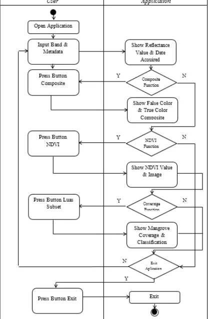
2. METHODS
The common method for Application of Mangrove Forest Coverage Detection started from the image selection process obtained from Band Landsat imagery. To get the input of the bands
images, user must first download it on
earthexplorer.usgs.gov site. Figure 1 is a Flowchart of processing method using the implementation of Remote Sensing.
Figure 1: Flowchart of Image Processing Method
Image processing is started with the input of the Band Landsat imagery. There are two processes before achieving the final outcome of Mangrove vegetation area, which are Composite and NDVI processes using Reflectance correction [12].
The next stage is to build an application. This application has two menus with different processing purposes. The first is the NDVI Tools menu. This menu has the ability to process Band
Landsat inputs in the form of image with TIF file format into information in the form of Mangrove coverage area. The second menu is the Coverage Changes menu. The menu has a function to display the Mangrove coverage area similar with the processing on the NDVI Tools menu, but this menu has more capabilities which can display Mangrove coverage area based on different date input as a comparison. This menu can also display the Mangrove area changes occur during a certain period. The entire process in this application can be seen in the following activity diagram.
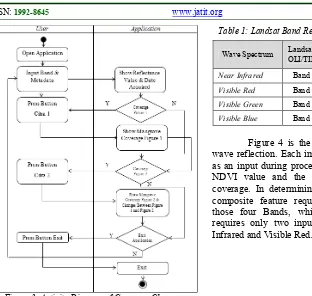
2.1 Activity Diagram
Activity diagram in NDVI Tools and Coverage Changes are displayed in Figure 2 and Figure 3. Figure 2 describes the course of activity of NDVI Tools menu displaying the course of the Band inputs to displaying the final result in the form of Mangrove coverage area. Figure 3 represents the course of activity of Coverage Changes menu displaying the courses of Band inputs to displaying final result in the form of the area comparison and the shift of value of Mangrove
coverage.
Journal of Theoretical and Applied Information Technology 31st October 2015. Vol.80. No.3
© 2005 - 2015 JATIT & LLS. All rights reserved.
ISSN: 1992-8645 www.jatit.org E-ISSN: 1817-3195
523 Figure 3: Activity Diagram of Coverage Changes
2.2 Bands Input
The images of Remote Sensing are attained from a particular satellite, aircraft, or other vehicle. Those images are originated from the
sensors recordings which have distinct
characteristics within each level of height, it determines the differences of the resulted data of Remote Sensing [7]. Landsat is one of distant sensing vehicle launched in 1972 [8]. The satellite images used in this study are originated from different Landsat satellites, they are Landsat 7 and Landsat 8. This Landsat image can be downloaded for free in http://earthexplorer.usgs.gov.
Landsat satellite has several
electromagnetic wave sensors with different recording specifications. The sensor of Landsat satellite is widely known as Band. In this study, the input of image is obtained from four types of Bands, which are Near Infrared Band, Visible Red Band, Visible Green Band, and Visible Blue Band. As seen in Table 1, Landsat satellite specifications have different Band numbers based on the types of captured electromagnetic waves.
Table 1: Landsat Band Requirements (Source: NASA).
Wave Spectrum OLI/TIRS Landsat 8 Landsat 7 ETM+
Spatial Resolution (one pixel)
Near Infrared Band 5 Band 4 30m x 30m
Visible Red Band 4 Band 3 30m x 30m
Visible Green Band 3 Band 2 30m x 30m
Visible Blue Band 2 Band 1 30m x 30m
Figure 4 is the images obtained from the wave reflection. Each image is going to be utilized as an input during processing process to determine NDVI value and the area of Mangrove forest coverage. In determining NDVI value, there is a composite feature requiring the combination of those four Bands, while the process of NDVI requires only two input Bands, which are Near Infrared and Visible Red.
Figure 4: Input Image
Figure 5 represents how subset process is conducted by using Region of Interest (ROI). Subset is the process of cutting the satellite images into the desired size. ROI data are in the form of vector standing as the administrative boundary of a region. This vector is available and it can be freely downloaded from several governmental sites.
Figure 5: Subset by Region of Interest
Journal of Theoretical and Applied Information Technology 31st October 2015. Vol.80. No.3
© 2005 - 2015 JATIT & LLS. All rights reserved.
ISSN: 1992-8645 www.jatit.org E-ISSN: 1817-3195
524 employed to identify the rate of greenery, this is advantageous for the classification of vegetation area. NDVI value is acquired from mathematical formula between Near Infrared Band and Visible Red Band [10]. Those two Bands are selected due to light reflection by objects (reflectance), light absorption by objects (absorption), and light transmission by objects (transmittance). Maximum reflection on vegetation occurs within the wave plength of Near Infrared. This maximum reflection is caused by the structure of the leaves (mesophyll) that can increase Near Infrared wave reflection. Maximum absorption occurs within the wave length of Visible Red. This absorption is caused by Chlorophyll [10].
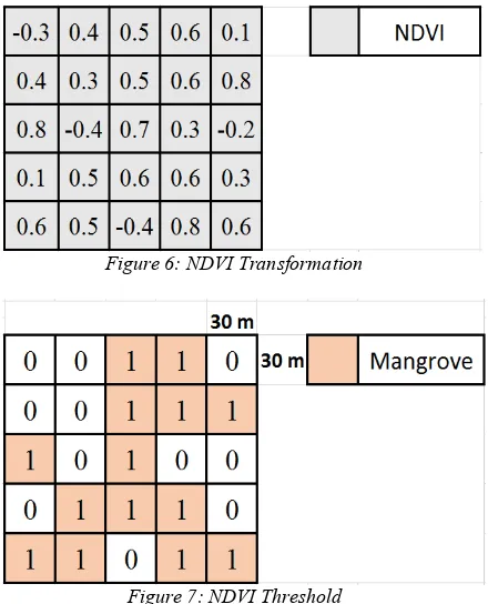
NDVI equation is the result of the subtraction of Near Infrared Band pixel value to Visible Red Band pixel value which is divided by the sum of Near Infrared Band pixel value to Visible Red Band pixel value. Band input which is formerly used must be corrected radio-metrically [12]. This process produces image with new pixel value as illustrated in Figure 6. Following is the formula of NDVI [11].
( (1)
NDVI process produces new image with the value of pixel ranges from -1 to +1. The positive value of pixel indicates the existence of vegetation, while the negative value of pixel indicates non-vegetation object. The classification of object constructed based on the value of NDVI is represented in Table 2 [13].
Table 2: NDVI Value.
Classifications NDVI Value
Cloud, Water, Snow < 0
Rocks and Bare Land 0 – 0,1
Grassland and Shrubs 0,2 – 0,3
Tropical Forests, Mangrove
Forest 0,4 – 0,8
2.3 NDVI Threshold
NDVI Threshold is the process of setting up range limitation to NDVI pixel value. In this research, Mangrove obtains NDVI Threshold with the range of NDVI pixel value of 0.4 to 0.8 referred to Table 2. The calculation of Mangrove coverage
area is administered by sum up NDVI pixels that gets into the range of NDVI Threshold. The total of pixel is multiplied by spatial resolution value of Landsat image, which is 30 x 30 (m2).
The illustration in Figure 7 shows the image of NDVI Threshold with the size of matrix of 5 x 5 obtaining new values; 14 pixel points which worth is 1 and 11 pixel points which worth is 0. The pixel point which worth is 1 is NDVI Threshold under the consideration that NDVI value of Mangrove ranges from > 0.4 and ≤ 0.8, hence, it can be ascertained that NDVI Threshold which worth is 1 is Mangrove vegetation.
Figure 6: NDVI Transformation
Figure 7: NDVI Threshold
Journal of Theoretical and Applied Information Technology 31st October 2015. Vol.80. No.3
© 2005 - 2015 JATIT & LLS. All rights reserved.
ISSN: 1992-8645 www.jatit.org E-ISSN: 1817-3195
525 Table 3: Coverage Classification.
Classifications NDVI Threshold
Very Rare 0,4 < NDVI ≤ 0,45
Rare 0,45 < NDVI ≤ 0.5
Medium 0,5 < NDVI ≤ 0.55
Full 0,55 < NDVI ≤ 0.8
3. RESULT AND DISSCUSION
The implementation of the method was managed by constructing a particular application. This application consists of two menus. The main menu are labeled as NDVI Tools. These menu can
process NDVI equations and provide the
information related to Mangrove forest coverage area in a certain date. Figure 8 shows the image of NDVI Tools.
Figure 8: NDVI Tools
The subsequent menu is Vegetation Changes menu. This menu processes NDVI equations from two inputs of images with different dates. Those inputs are processed to form a new image and displayed, the areas are compared afterwards. The menu of Vegetation Changes is represented in Figure 9.
Figure 9:Vegetation Changes
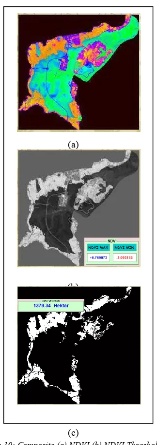
Experiment was carried out by examining some functions in NDVI Tools menu and Vegetation Changes menu. Band Composite was conducted by combining three Band inputs and putting color intensity over those Bands. Those
three Band inputs are Near Infrared Band, Red Band, and Blue Band. The colors displayed are dominant rather than the other objects, it makes Mangrove objects easily recognized. The process of Band Composite is depicted in Figure 10a.
(a)
(b)
(c)
Figure 10: Composite (a) NDVI (b) NDVI Threshold (c)
Journal of Theoretical and Applied Information Technology 31st October 2015. Vol.80. No.3
© 2005 - 2015 JATIT & LLS. All rights reserved.
ISSN: 1992-8645 www.jatit.org E-ISSN: 1817-3195
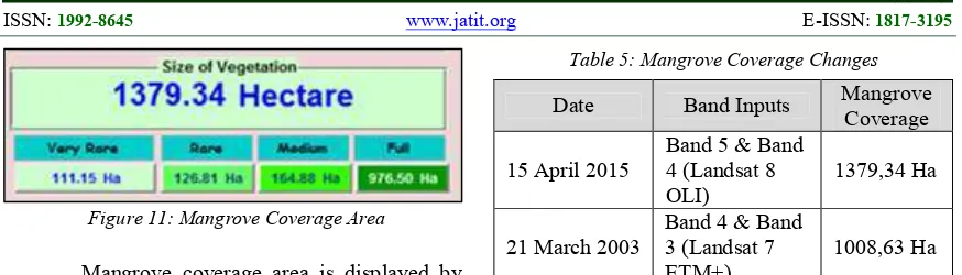
526 Figure 11: Mangrove Coverage Area
Mangrove coverage area is displayed by using the unit of hectare. Figure 11 shows Mangrove coverage area in Ngurah Rai Grand Forest Park in 15th of April 2015. The showed Mangrove coverage area is classified into several classes of coverage and the results can be seen in Table 4.
Table 4: Coverage Results (15 April 2015).
Classifications Result
Very Rare 111.15 Hectare
Rare 126.81 Hectare
Medium 164.88 Hectare
Full 976.50 Hectare
The Changes of area is displayed by using the unit of hectare similar to the calculation of Mangrove forest coverage area. Figure 12 represents the changes of Mangrove coverage area occurring in 21st of March 2003 and 15th of April 2015.
Figure 12: Mangrove Coverage Changes
The area calculation conducted in 21st of March 2003 required inputs of images obtained from Landsat 7 satellite, while The area calculation conducted in 15th of April 2015 required inputs of images obtained from Landsat 8 satellite. By referring to Table 1, the wave of Near Infrared in Landsat 7 was captured by sensor Band 4 and the wave of Visible Red was captured by sensors Band 3. Further explanations are presented in Table 5, it includes the inputs and the results of area calculation.
Table 5: Mangrove Coverage Changes
Date Band Inputs Mangrove
Coverage
15 April 2015
Band 5 & Band 4 (Landsat 8 OLI)
1379,34 Ha
21 March 2003
Band 4 & Band 3 (Landsat 7 ETM+)
1008,63 Ha
Based on the explanations given in Table 5, it can be stated that Mangrove forest in Ngurah Rai Grand Forest Park undergoes a coverage of area which is 1008.63 hectares into 1379.34 hectares.
4. CONCLUSIONS
The area calculation and the shift of Mangrove forest coverage area administered by using NDVI transformation method are effective since Mangrove vegetation in Ngurah Rai Grand Forest Park spreads widely and homogenously. To facilitate the area calculation and shift, Matlab language programming-based application was constructed. This application requires image input which is originated from Landsat satellite. This image input was used in this research administered in 21st of March 2003 and 15th of April 2015. The Mangrove coverage area in 2015 is 1379.34, while it is only 1008.63 in 2003, it can be stated that there is area alteration as much as 370.71 hectares. Therefore, it can be concluded that Mangrove coverage in Ngurah Rai Grand Forest Park increases as much as 370.71 hectares within 12 years.
5. FURTHER RESEARCH DIRECTION
Vegetation analysis using Vegetation Index transformation is not limited to the use of NDVI method, it is expected that the development of this application does not focus on NDVI method and Mangrove forest only. The selection of Vegetation Index method should be conformed to the kinds of vegetation, whether the vegetation is heterogeneous or homogeneous.
ACKNOWLEDGEMENT
Journal of Theoretical and Applied Information Technology 31st October 2015. Vol.80. No.3
© 2005 - 2015 JATIT & LLS. All rights reserved.
ISSN: 1992-8645 www.jatit.org E-ISSN: 1817-3195
527 assistance this research.
REFRENCES:
[1] Nontji, Anugrah. Laut Nusantara. Djambatan, Jakarta, 2005.
[2] Yunhao, C., S. Peijun, L. Xiaobing, C. Jin, and L. Jing. A Combined Approach for Estimating Vegetation Cover in Urban/Suburban Environments From Remotely Sensed Data. Computers & Geosciences, 2006. 32. pp. 1299 – 1309.
[3] Horning, N. Global Land Vegetation; An
Electronic Textbook. NASA Goddard Space Flight Center Earth Sciences Directorate Scientific and Educational Endeavors (SEE). 2004.
[4] Ji, L., A.J. Peters. Performance Evaluation of Spectral Vegetation Indices Using a Statistical Sensitivity Function. Remote Sensing of Environmental. 2007. 106, 59 – 65.
[5] Danoedoro. P. Pengolahan Citra Digital, Teori dan Aplikasinya dalam Penginderaan Jauh.
Fakultas Geografi Universitas Gadjah Mada, Yogyakarta. 1996. pp. 253.
[6] Purwadhi. S.H. Interpretasi Citra Digital.
Gramedia Widiarsana Indonesia. Jakarta, 2001.
[7] Richards, John.A. Jia, Xiuping. Remote
Sensing Digital Image Analysis; An Introduction. Springer, 2006.
[8] Sutanto. Penginderaan Jauh Jilid 2. Gajah Mada University Press, Jogjakarta. 1994.
[9] Arnanto, Ardi. Pemanfaatan Transformasi
Normalized Difference Vegetation Index (NDVI) Citra Landsat TM Untuk Zonasi Vegetasi di Lereng Merapi Bagian Selatan.
Geomedia, 2013. Vol. 11, No. 2. pp. 166 – 168.
[10] As-syakur, A.R., I W.S. Adnyana. Analisis
Indeks Vegetasi Menggunakan Citra
Alos/Avnir-2 nan Sistem Informasi Geografi (SIG) Untuk Evaluasi Tata Ruang Kota Denpasar. Jurnal Bumi Lestari, 2009. Vol. 9, No. 1. pp. 1 – 11.
[11] Jensen, J.R. Remote Sensing of The
Environmental Earth Resource Perspective.
Prentice Hall. New Jersey-USA. 2000.
[12] Kustiyo. Dewanti, Ratih. Lolitasari, Inggit.
Pengembangan Metoda Koreksi Radiometrik Citra SPOT 4 Spektral dan Multi-Temporal Untuk Mosaik Citra. Prosiding. SINASINDERAJA. Bogor, 2014 p. 82 – 83.
[13] Benny. NDVI. Bennys Idea.