USING GEO-DATA CORPORATELY ON THE RESPONSE PHASE OF EMERGENCY
MANAGEMENT
E. Demir Ozbek a,b*, S. Ates a,b, A.C. Aydinoglu c
a 3D Geoinformation, Delft University of Technology, Delft, The Netherlands-
(s.ates, e.demirozbek)@tudelft.nl
b Dept. of Geomatics Engineering, Istanbul Technical University, 80626 Maslak Istanbul, Turkey - (atesser, demirelif)@itu.edu.tr
c Dept. of Geomatics Engineering, Gebze Technical University, 41400 Gebze, Kocaeli, Turkey - [email protected]
Commission IV, WG IV/7
KEY WORDS: Disaster Management, Emergency Response, Geo-data Management, Standard Operating Procedures (SOP), Health Services, Ambulance, Optimization.
ABSTRACT:
Response phase of emergency management is the most complex phase in the entire cycle because it requires cooperation between various actors relating to emergency sectors. A variety of geo-data is needed at the emergency response such as; existing data provided by different institutions and dynamic data collected by different sectors at the time of the disaster. Disaster event is managed according to elaborately defined activity-actor-task-geodata cycle. In this concept, every activity of emergency response is determined with Standard Operation Procedure that enables users to understand their tasks and required data in any activity. In this study, a general conceptual approach for disaster and emergency management system is developed based on the regulations to serve applications in Istanbul Governorship Provincial Disaster and Emergency Directorate. The approach is implemented to industrial facility explosion example. In preparation phase, optimum ambulance locations are determined according to general response time of the ambulance to all injury cases in addition to areas that have industrial fire risk. Management of the industrial fire case is organized according to defined actors, activities, and working cycle that describe required geo-data. A response scenario was prepared and performed for an industrial facility explosion event to exercise effective working cycle of actors. This scenario provides using geo-data corporately between different actors while required geo-data for each task is defined to manage the industrial facility explosion event. Following developing web technologies, this scenario based approach can be effective to use geo-data on the web corporately.
* Corresponding author
1. INTRODUCTION
Planning faults in parallel with the increase in population causes to important losses as a result of the disasters such as earthquake, flood, fire, etc. Disaster and emergency management activities can be grouped into four phases called mitigation, preparation, response and recovery that are related by time and function to all types of emergencies and disasters. These phases are also related to each other, and each involves different types of skills. Various actors such as fire brigade, ambulance, etc. get roles in emergency management activities. The intervention of the actors involved in emergency management in a well-coordinated manner, in an effective way and in a short period of time has become a crucial need.
During the response phase, largely there is a local effort to cope with the disaster itself as it happens, to rescue victims, and to provide short-term relief to victims. It involves mobilizing and positioning emergency equipment; getting people out of harm’s way; providing needed food, water, shelter, and medical services; and bringing essential services back on line (Craig A. et al., 2005). Due to the direct response in human life, response phase is supposed to be the most effective one that system is used. It covers the activities such as; determination of response
area, response planning, evacuation planning and recovery plans and aid planning.
Disaster response includes the actions taken in anticipation of, during, immediately and after an emergency to ensure that its effects are minimized. Coordinated work of actor agencies carries great importance in terms of effective performance of activities at the response phase of the disaster management (Demir et al., 2011). The importance of a timely, coordinated approach to disaster response is essential with greater demands being placed upon resources due to the increase in urbanization, proximity of industry to high-density areas, and urban congestion. This timely, coordinated approach requires the clear definition of roles and responsibilities of those involved in response activities. Activities are designed to provide emergency assistance for victims. They also seek to stabilize the situation and reduce the probability of secondary damage (shutting off contaminated water supply sources, securing and patrolling areas prone to looting etc.) and to speed recovery operations (Queensland Government, 2010).
Geospatial information accessible through information services allows more timely interventions of teams and more efficient management of the operation on site. Additionally, non-spatial information like procedures, emergency plans and authorization The International Archives of the Photogrammetry, Remote Sensing and Spatial Information Sciences, Volume XL-3/W3, 2015
modules can be quickly accessed and communicated. Further, information on critical infrastructures and services damaged by the event will be needed in order to prioritize actions needed to protect the affected society. Finally, efficient and reliable communication channels will be necessary to assure the transportation of this information between the appropriate decision makers and other emergency management actors (ORCHESTRA, 2008).
The paper is organised as follows. First, Section 2 describes the current situation of disaster response and health service in Turkey. Section 3 discusses how geo-data was used corporately on the response phase of the disaster and the emergency management. Section 4 presents the general conceptual approach for disaster and emergency management and the implementation of this approach with ambulance case study. Section 5 presents conclusions and gives information about further research topics.
2. DISASTER AND EMERGENCY RESPONSE MANAGEMENT IN TURKEY
The model of National Disaster Response System is formed in the triangle of Prime Ministry Disaster and Emergency Management Center (PMDEMC), Ministry Disaster and Emergency Management Center (MDEMC) and Provincial Disaster and Emergency Management Center (PDEMC) at national level in Turkey (Official Gazette of Turkey 2013). Service groups at national level constituted at the level of ministry, institutions and organizations set a concerned part of service model in national service group plan. These service models form parts of national disaster response system.
National Disaster Response Organization has four service groups: Operation Service Group, Logistics and Maintenance Service Group, Information and Planning Service Group and Finance and Administrative Affairs Service Group. Operation Service Group is an actual responsible for disaster response and is divided into two groups: Emergency Service Group and Pre-Recovery Service Group. Health Service is a part of Emergency Service Group to play a critical role in disaster response phase (AFAD, 2013).
Ministry of Health is the responsible institution for Health Service at national level. General Staff, Ministry of Environment and Urban Planning, Ministry of Food, Agriculture and Livestock, Ministry of Interior, Red Crescent, non-governmental organizations and private sector are supporting solution partners working in conjunction with Ministry of Health. Health Service has activities in disaster types of flood, dam explosion, forest fire, industrial fire, collective population movement, chemical disasters, biological disaster and epidemics, radiologic and nuclear accidents, drought, earthquake and transportation (Official Gazette of Turkey, 2013).
Relation between service groups at national and local level is the implementation of supporting functions in disaster region. Disaster response management at local level is designed as a single model by national level on the purpose of ensuring the standardization throughout the country. Response management organization is identical at local and national level. Each service formed at national level has a representative in local level. These representatives manage their institutions responsibilities for disaster response in 112 Emergency Call Centers in
provinces. 112 Emergency Call Center is the operational part of Turkey Disaster and Emergency Response Management.
2.1 112 Emergency Call Center
112 Emergency Call Center is established to answer, refer and coordinate all kinds of emergency calls which fall into responsibility area of related institutions and organizations. Presidency is established within the governorship and covers the provincial administrative boundaries. According to (Official Gazette of Turkey, 2014) the role of the 112 Emergency Call Center Presidency is determined as;
Taking the emergency call in responsibility area of provincial gendarmerie command, provincial security directorate, coast guard command, municipalities, regional directorate of forestry, directorate of nature conservation and national parks, provincial directorate of health, provincial disaster and emergency management directorate and other institutions specified by governorate and taking due precautions.
Dispatching the emergency calls to related institutions (security, health, fire brigade, etc.) rendering emergency aid service in the call center.
Providing the coordination and cooperation between different institutions rendering emergency aid service according to needs of the disaster.
Establishing and operating the mobile centers that provide the communication and management relating to answering and forwarding emergency call in the incident area.
Assigning a place in 112 emergency call center for the related institutions according to their needs.
At provincial level, gendarmerie command, security directorate, coast guard command, metropolitan municipalities and mayorship, regional directorate of forestry, directorate of nature conservation and national parks, directorate of health, disaster and emergency management directorate and other institutions specified by governorate are located in 112 Emergency Call Center.
In case of disaster and emergency, all type of information related with different sectors collected in emergency call center. Call receivers answer the emergency call, determine if the call is compatible with management rules of the call center, fill the incident information form according to location of the incident and dispatch the call to the related institution. According to information registered by call receiver, call dispatchers evaluate the call if the call is fall into their responsibility area and if the call is emergency incident. After confirming the call he/she complete the incident information form if there is a lack of information, inform other related institutions if more than one institution is needed, coordinate with institution related with same incident, assign sufficient number of teams that are closer to incident scene and have required equipment and record the dispatched team’s time of; departure, arrival on scene, departure from scene, arrival to hospital, departure from hospital and return back to station by using vehicle tracking system.
3. GEO-DATA MANAGEMENT ISSUES ON THE RESPONSE PHASE
Disaster and Emergency Management is a complex and very wide discipline that includes many actors and needs large amount of information. The most important base for an effective disaster management is the healthy and accurate maps. Maps are the bases that incorporate regional information related to any disaster or potential emergency case. According to the The International Archives of the Photogrammetry, Remote Sensing and Spatial Information Sciences, Volume XL-3/W3, 2015
information contained, healthy and accurate produced map information (geo-data) is the first necessity for performing activities such as accessing to the region in emergency cases, keeping track of rescue operations and logistics services in mitigation and preparation phases. In this context, using GIS in disaster management helps to control destructions, reduce damage results of disasters and protect lives and resources. GIS support decision making and facilitate optimum solution finding for complex problems. Due to GIS functions, information from other sources can be processed with geo-data. That way, analysis related to emergency are performed with different input layers such as; road, building, watercourse, land cover and so on. Geo-data which is obtained from location based observations and expressed as map information, is extensively used in different phases of disaster management.
When disaster occurs, it is required to react accurately, fast and effectively. Various actors from different sectors such as police and health units are involved in emergency management. Building a good collaboration mechanism and cross-sector services have critical importance to manage emergency tasks that are rather different than their daily work routines (Scholten et al., 2008). By this way, good decision making and information management help to control damage, to save life and resources, and to reduce consequences of a crisis.
There are various necessary information in disaster management and response. Almost everything in a disaster is related to a location, and often location is the most important attribute of information. Various geo-data sets, existing and dynamic data are needed on emergency response and management.
Existing data, were produced by different organizations on heterogeneous environment such as topographic maps, administrative units and risk objects; vulnerable objects like schools, government buildings, hospitals and the location of emergency response teams.
Dynamic data, is collected during the disaster from the activities of emergency management such as incident data includes location, nature, and scale. Effects of disasters should be determined with real time data including damaged objects, buildings, and infrastructures, affected and threatened areas. Casualties as a possible result of disasters include wounded and trapped people. In addition to this, meteorological data includes wind, humidity, and precipitation. This up-to-date geo-data is obtained on actual situation and can help to analyse possible effects and to determine precautions. The location of emergency response teams are needed as a moving object for giving the route to incident location. This dynamic data is very wide depending on the nature and data needs of emergency situations. By this way, dynamic data produced on real time can support controlling emergency response activities together with the use of existing data.
Dynamic information consists of situational information about the incident and its effect, and operational information about the processes activated to handle an incident, responsible departments/persons and their roles (Dilo & Zlatanova, 2011). Situational information covers type, scale, and affected area of an incident; casualties (trapped, missing, injured people), measurements (in case of detection of dangerous substances in the air, water or in the ground). Operational information is related to teams, involved in the disaster and emergency response, teams performing measurements, process started to
handle a disaster and involved departments (Pan American Health Organization, 2009).
There is growing recognition in the emergency management community of the value of location or geo-data. Thus, Geo-Information Systems (GIS) technology is increasingly being employed in disaster management to provide a powerful decision support to find optimal solutions to complex problems on emergency management. But, the integration of geo-information through interoperable systems is the central role of Geographic Information Infrastructure (GII) because it provides information from different sources for effective delivery of government services. By this way, GII is increasingly considered a critical aspect of decision-making and response in emergency management.
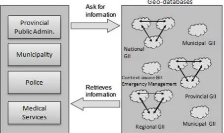
From a technical point of view, standard implementations are required for access and exchange of geo-information These include OGC Web Services, GML, Geo-decision support services (GeoDSS), Geo-Digital Right Management (GeoDRM) and Open Location services (OpenLS). The use of web services and XML can be considered for the communication between the systems in this architecture (OGC, 2008). On networked environment, there are a great diversity clients ranging from rich clients based on web browsers over classic workstation applications to mainframes with terminals (Aydinoglu et al., 2009). Geo-information should be shared and can be immediately retrieved from the sources involved in different databases. The services should be a part of GII that integrates and facilitates access to existing and dynamic data on emergency management. Defining and implementing a GII within context aware services is the main focus as seen on Figure 1. The applications are directly communicating with services within these data driven GIIs.
Figure 1. An Overview of context-aware GDI for disaster management (adapted from (Borkulo et al. 2006)).
There are many approaches mentioned for reaching semantic interoperability on highly heterogeneous programming and data models. Important technology progress has been made in the discipline of knowledge engineering such as Unified Modelling Language (UML), ontology, and semantic web. For example, UML is a standardized modelling language for object modelling, is a graphical modelling tool with well-defined semantics and underlying computer model in a Model Driven Approach (MDA). It is developed for the purpose of general domain modelling, application system design, database design, and business modelling and so on.
4. CASE STUDY
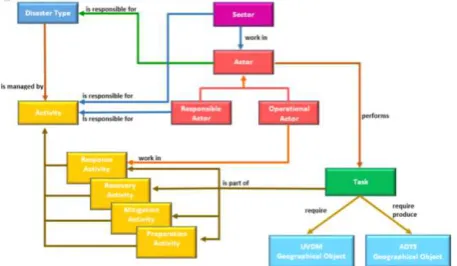
The conceptualization of Disaster and Emergency Data Model is based on providing the most effective data flow in disaster and emergency management. Thus, the general conceptual approach of Disaster and Emergency Management System is defined with Disaster Type-Sector-Actor-Activity-Service- Data components (Figure.2).
Figure 2. General conceptual approach for Disaster and Emergency Management System
Disaster Type: According to (AFAD, 2013), 12 disaster types are defined in Turkey. These are; flood, dam explosion, forest fire, industrial fire, collective population movement, cyber attack, chemical disasters, biological disaster and epidemics, radiologic and nuclear accidents, drought, earthquake, transportation accidents.
Sector: Health sector is responsible for activities which are defined for all disaster types except cyber attack.
Actor: Actor is an organization, institution or a person which is responsible for sub-activities of disaster and emergency management. Every sector (police, municipality, and health services) has more than one actor with different roles such as fire fighter, ambulance, public security team, and etc. Ambulance is working as an actor of the health sector. According to their roles two types of actor can be identified; responsible actors and operational actors. Responsible actor is liable for activities at preparation, mitigation, response and recovery phase of emergency and disaster management. Operational actor is responsible for possible sub activities of the response phase. For example; while a Health Call Dispatcher is determining ambulance route, an ambulance medical team provide response service to casualties.
Activity: Activity expresses use of geo-data in required situations during mitigation, preparation, response and recovery phases of disaster and emergency management. Ambulance has critical roles in several activities such as; dispatching sufficient staff, vehicle, equipment and material to disaster region, ensuring triage, first aid and emergency medical aid to disaster region and ensuring medical evacuation and patient treatment. Disaster type is managed according to activities determined in different phases of disaster management.
Task: Every activity is composed of specific sub tasks. For example, tasks such as registering of the scene, determining ambulance routes, etc. are sub parts of the activity. In other words, emergency activities comprise tasks respectively and an actor performs task. Disaster and Emergency Management System geo-database. And, this task produces some dynamic data on ADYS geodatabase during disaster.
Response phase of the emergency management involves multiple actors that must work with each other corporately. Determining actors that take part in emergency management is the first step for effective response in emergency management.
4.1 Optimizing Ambulance Locations
Disaster and emergency situations are managed with the help of processes at four phases such as; mitigation, preparation, response and recovery. In mitigation phase, actions and analysis are carried out to prevent occurrence of disasters. In preparation phase, required analysis are done to reduce the damage caused by the disasters and preparation processes are realized for response phase. For industrial fire case, mitigation phase of the disaster is composed of two processes such as risk analyses and risk mitigation planning.
- Risk analyses process activities: hazard analysis, vulnerability analysis and risk analysis activities.
- Risk mitigation planning process activities: risk zone planning, hazard zone planning, vulnerable zone planning and disaster mitigation planning.
o Sub-activities of the disaster mitigation planning activity: buffer zones, fire safety roads, establishing firebreaks, spill control and drainage system, system designing and environmental planning of risk objects.
In preparation phase, geodata that is produced in mitigation phase is used to reduce the damage. Emergency preparedness is evaluated in terms of response times, and risk is measured in terms of affected population, disaster potential, and the emergency preparedness of the area. For emergency preparedness and disaster management key objects include locations of emergency responders such as police stations, ambulances, firefighters, hazardous material response teams. All these actors must be distributed effectively to reduce the damage caused by an event.
The processes of preparation phase of industrial fire can be summarized as; ‘Response Planning’, ‘Evacuation Planning’, ‘Relief Planning’ and ‘Early Warning System Planning’ processes are required in the preparation phase of industrial fire case. Response planning process activity is composed of firefighting requirements analysis, search and rescue requirements analysis, first aid requirements analysis, CBRN requirement analysis, response units planning and response source planning activities.
Optimization process as a part of response units, is a planning activity of emergency responders’ locations to identify the maximum coverage that can be achieved according to given specific constraints. It is very effective in evaluating response times of emergency response units that shows the service area covered by the emergency responder within a specific time given specific travel times. With the emergency response units serving as centers, the extent of the coverage available for various desired response times can be evaluated.
In the case study, ‘optimizing the location of the ambulance stations’ sub-activity of the ‘Response Units Planning’ activity is realized in the preparation phase of the industrial fire case. The responsible institution is determined as ‘Provincial Directorate of Health’. The tasks, geodata needs and detailed description about these geodata is given in Table 1.
Table 1. Data requirement analyse for ‘Optimising the Location of Ambulance Stations’ activity
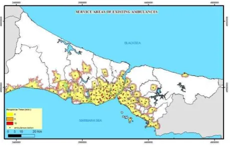
An example of service area for ambulance stations according to the 6,8,10 minute response time in Istanbul is shown in the Figure 3. Response time interval is provided from previous studies and 8 minute is accepted for first aid emergency actions and 10 minute is accepted for general emergency actions with 2 minutes delay time (Ates et al., 2011).
Figure 3. Service areas of existing ambulance stations
Optimization process is done for ambulance services to provide optimum distribution of ambulance stations which provide Emergency Medical Services without exceeding 8 minutes response time. Two minutes delay time is not take into account for effectively using of travel times of ambulances. In this context, existing ambulance locations’ service areas are determined with Network Analysis. As a result, optimum ambulance locations and number of the ambulances are defined with respect to population, closeness to main roads and cases which require emergency action. While existing number of the ambulance stations is 120, the number increase to 160 and 279 ambulance vehicles added to the system. In this way the problems in using Emergency Medical Services resources and late responses will be decreased (Figure 4).
Figure 4. Distribution of ambulance stations after optimization process.
4.2 Emergency Response Activity
Static data from Turkey National GIS (TUCBS) and DEMS that are produced in mitigation and response phases and dynamic data produced by actors along the response services are used in industrial fire response. Emergency response scenarios can be determined to define the geodata requirement and manage emergency activities. For example, industrial facility explosion as the activity has following work cycle as seen below;
Call Reciever in 112 Emergency Call Center takes the emergency call.
After getting an emergency call, “Actor:CallReceiver” performs the task “RegisteringTheIncident”. “RegistringTheIncident” task includes information about the disaster type and incident location. This requires “Road” and “Numbering” data on main geo-database. This task produces the location of “Incident” which is dynamic data on emergency management database. In this case, “DisasterType” is represented with “IndustrialFacilityExplosion”.
“RegistringTheIncident” task is performed on emergency call software. Emergency Call Software ensures the registration of emergency call, keeping statistics of emergency calls and monitoring the activities of services.
Call receiver informs the concerned services to manage the incident. Various sectors such as “Communication Service”, “Search and Rescue Service”, “Evacuation and Settlement Planning Service”, “CBRN Service”, “Transportation Infrastructure Service”, “Security and Traffic Service”, “Transportation Service”, “Energy Service”, “Health Service”, “Damage Assessment Service”, “Infrastructure Service”, “Debris Removal Service” and “Sheltering Service” have responsibilities for some activities of “DisasterType: IndustrialFacilityExplosion”
Various actors such as “Police, Ambulance, Fire Brigade, Electricity Distribution Inc. (BEDAS) and Natural Gas Distribution Company (IGDAS)” are involved in concerned sector to response the incident.
The activity “Explosion” is one of the activity for which “Health Service” is responsible.
The tasks such as “registering the incident, determining affecting areas and building, navigating emergency services for response (ambulance, police, firefighter, and utility service), evacuating and controlling affecting area, fire intervention, and saving casualties” are parts of the activity “explosion”.
Fire Brigade performs the tasks “determining affecting area and building” requiring “Numbering”, “Road”, and “Building” data. This task produces “AffectingArea” on main geo-database. As a case study, possible explosion was examined and the “AffectingArea” including threatening building were determined The International Archives of the Photogrammetry, Remote Sensing and Spatial Information Sciences, Volume XL-3/W3, 2015
(Figure 5-a). Data requirement analysis for “Determining Affecting Area and Building” task is shown in Table 2.
Table 2. Data requirement analyse for ‘Determining Affecting Area and Building’ activity.
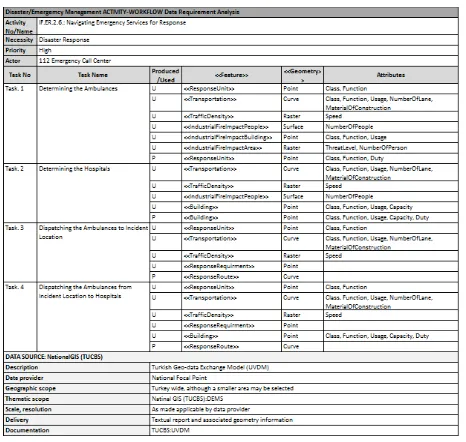
Security and Traffic Service performs the task “navigating emergency services for response” requiring “Incident”, “Road”, “Teams” data to produce “TrafficAccessMap” on emergency management database. As a case study, produced map give optimum routes to fire fighters and ambulances to reach the location of incident as (Figure 5-b). Data requirement analysis for “Navigating Emergency Services for Response” task is shown in Table 3.
Table 3. Data requirement analyse for ‘Navigating Emergency Services for Response’ activity.
Health Service Call Dispatcher as a responsible actor performs “NavigatingAmbulance” task. This task requires “Incident”, “AffectingArea”, “TrafficAccessMap” and “AmbulanceLocation” data which is optimized in preparation phase and which can be obtained at the time of disaster (dynamic). Ambulance as an operational actor perform “CasulatyResponse” task and produce ambulance location data.
For “NavigatingAmbulance” task, “Incident” data is produced by Call Reciever, “AffectingArea” is produced by Fire
Brigade and “TrafficAccessMap” is produced by Security and Traffic Service at the time of disaster. Different actors coordinately perform their tasks
Beside these, geo-data is required and produced to execute other tasks of this emergency response.
To manage emergency response activities, it is required to produce Standard Operating Procedures (SOP) with detailed description of actors, activities, and working cycle that describe required geo-data.
Figure 5. a) Affecting areas for explosion b) Traffic access map.
5. CONCLUSIONS AND FURTHER RESEARCH
Geo-data has great importance at different phases of disaster management; preparedness, mitigation, response, and recovery. As emergency management is a multi-disciplinary activity, the most fundamental asset is the data itself that needs to be shared or to be integrated between different partners. GII provides tools giving easy access to distributed databases for emergency management actors who need geo-data for their own decision making and emergency tasks. It provides using geo-data corporately between different actors in an emergency management activity. By this way, geo-information technologies solve application-driven geospatial data needs quickly and support decision-making process. If standard operation procedure is determined and implemented at the phase of emergency management, activities with tasks should be formalized sequentially while required data for each task should be defined to manage disaster events within GII mechanism that supporting data sharing and interoperability. Similar to the case study, Actor-Sector-Activity-Task-Data classes have been designed for emergency management activities. Processes with tasks were being formalized sequentially while required data for each task were defined to manage.
The main contribution of this paper can be characterised as a proposed general conceptual approach for disaster and emergency management system. Findings gathered from the case study presents that it is required to determine actors, activities, and working cycle that describe required geo-data to manage emergency response activities. The geo-data used at disaster management can be grouped into two classes; static data such as building, road and utility network etc., and dynamic data such as disaster event information, number of victims etc. While the geo-data gathered during the disaster named as operational data (dynamic), the data gathered before disaster named as current data (static). Dynamic data has an important role at response phase of the disaster management. This type of data will be gathered from tasks carried out by actors that are determined according to the type and scale of the disaster. Data about victim (injured, slightly injured, dead, dead and lost, etc.) must be updated regularly to provide the most The International Archives of the Photogrammetry, Remote Sensing and Spatial Information Sciences, Volume XL-3/W3, 2015
effective response. The model explained in this paper includes only dynamic data gathered from first responders. In the implementation of the designed conceptual approach it is determined that management of dynamic data gathered from different institutions need to be studied more in detail. As can be seen in the case study, the dynamic data at the time of disaster will be gathered from various institutions and will be used at various activity corporately.
REFERENCES
AFAD, 2013. Disaster Response Plan of Turkey, Ankara, Turkey.
Ates, S., Aydınoglu, A.C. & Coskun, M.Z., 2011. Determining Optimum Ambulance Locations for Heart Attack Cases with GIS. In 2011 Esri International User Conference. San Diego, USA.
Aydinoglu, A.C., Quak, W. & Yomralioglu, T., 2009. Some Spatial Data Management Issues towards Building SDI. International Workshop on Spatial Information for Sustainable Management of Urban Areas,FIG Commission 3 Workshop 2009, (February 2009), pp.2–4.
Borkulo, E. Van et al., 2006. Services for an emergency response system in the netherlands. In Second Symposium on Gi4DM. Goa, India, pp. 1–6.
Craig A., M. et al., 2005. Professional Competencies for the Master’s Level Emergency Manager: Knowledge Systems Necessary for the Emergency Manage of the 21st Century,
Demir, E., Yomralıoglu, T. & Aydinoglu, A.C., 2011. Using Geo-Information Technologies to Increase the Effectiveness of Fire Brigade Services in Turkey. In Proceedings of the 8th International ISCRAM Conference. Lisbon, Portugal, pp. 1–5.
Dilo, A. & Zlatanova, S., 2011. A data model for operational and situational information in emergency response: The Dutch case. Applied Geomatics, 3(4), pp.207–218.
Official Gazette of Turkey, 2014. 29002 Numbered 112 Emergency Call Center Constitution, Assignment and Work Regulation, Republic of Turkey, Ankara.
Official Gazette of Turkey, 2013. Disaster and Emergency Response Services Regulation.
OGC, 2008. OGC-Open Geo Spatial Concortium Topic 1,5,8,10.,
ORCHESTRA, 2008. Orchestra book: An Open Service Architecture for Risk Management,
Pan American Health Organization, 2009. Information management and communication in emergencies and disasters: manual for disaster response teams S. A. Barrantes, M. Rodriguez, & R. Pérez, eds.,
Queensland Government, 2010. Disaster Management Strategic Policy Framework,
Scholten, H. et al., 2008. Spatial Data Infrastructure for emergency response in Netherlands. Remote Sensing and GIS Technologies for Monitoring and Prediction of Disasters,
pp.179–197. Available at:
http://www.gdmc.nl/publications/2008/SDI_Emergency_Respo nse_Netherlands.pdf.