QUALITY ASSESSMENT AND COMPARISON OF SMARTPHONE AND LEICA C10
LASER SCANNER BASED POINT CLOUDS
Beril Sirmacek∗, Roderik Lindenbergh, Jinhu Wang
Department of Geoscience and Remote Sensing, Delft University of Technology, Stevinweg 1, 2628CN Delft, The Netherlands
(B.Sirmacek, R.C.Lindenbergh, Jinhu.Wang)@tudelft.nl
Commission V, WG V/3
KEY WORDS:3D City Models, Point Clouds, Terrestrial Laser Scanning (TLS), Structure from Motion (SfM), Multi-view Pho-togrammetry, Low-cost sensors
ABSTRACT:
3D urban models are valuable for urban map generation, environment monitoring, safety planning and educational purposes. For 3D measurement of urban structures, generally airborne laser scanning sensors or multi-view satellite images are used as a data source. However, close-range sensors (such as terrestrial laser scanners) and low cost cameras (which can generate point clouds based on photogrammetry) can provide denser sampling of 3D surface geometry. Unfortunately, terrestrial laser scanning sensors are expensive and trained persons are needed to use them for point cloud acquisition. A potential effective 3D modelling can be generated based on a low cost smartphone sensor. Herein, we show examples of using smartphone camera images to generate 3D models of urban structures. We compare a smartphone based 3D model of an example structure with a terrestrial laser scanning point cloud of the structure. This comparison gives us opportunity to discuss the differences in terms of geometrical correctness, as well as the advantages, disadvantages and limitations in data acquisition and processing. We also discuss how smartphone based point clouds can help to solve further problems with 3D urban model generation in a practical way. We show that terrestrial laser scanning point clouds which do not have color information can be colored using smartphones. The experiments, discussions and scientific findings might be insightful for the future studies in fast, easy and low-cost 3D urban model generation field.
1 INTRODUCTION
Low-cost sensors are potentially an important source for auto-matic and instant generation of 3D models which can be useful for quick 3D urban model updating. However, the quality of the models is questionable and the user may not have a good opinion about how to collect images for the best 3D modelling results.
In this paper, we evaluate the reliability of point clouds generated automatically by multi-view photogrammetry applied on smart-phone camera images. Next, we show how to align uncalibrated smartphone based point clouds with laser scanning point clouds for comparison. We also discuss further applications where smart-phone based point clouds can be useful in terms of time, budget and man effort efficiency.
2 RELATED LITERATURE
Modelling 3D urban structures gained popularity in urban mon-itoring, safety, planning, entertainment and commercial applica-tions. 3D models are valuable especially for simulaapplica-tions. Most of the time models are generated from airborne or satellite sensors and the representations are improved by texture mapping. This mapping is mostly done using optical aerial or satellite images and texture mapping is applied onto 3D models of the scene. One of the traditional solutions for local 3D data capturing is the use of a Terrestrial Laser Scanner (TLS). Unfortunately, these devices
∗Corresponding author
are often very expensive, require careful handling by experts and complex calibration procedures and they are designed for a re-stricted depth range only. On the other hand, high sampling rates with millimetre accuracy in depth and location makes TLS data a quite reliable source for acquiring measurements. Therefore, herein we use TLS data as reference to evaluate the accuracy of the iPhone point cloud. An overview and the major differences between TLS and multi-view 3D model generation technologies are explained by Baltsavias (1999).
algo-rithm to reconstruct 3D building models by using images taken from smart phones with GPS and g-sensor (accelerometer) in-formation. Fritsch et al. (2011) used a similar idea for 3D re-construction of historical buildings. They used multi-view smart phone images with 3D position and G-sensor information to re-construct building facades. Bach and Daniel (2011) used iPhone images to generate 3D models. To do so, they also used multi-view images. They extracted building corners and edges which are used for registration and depth estimation purposes between images. After estimating the 3D building model, they have cho-sen one of the images for each facade with the best looking angle and they have registered that image on the 3D model for tex-turing it. They have provided an opportunity to the user to se-lect their accurate image acquisition positions on a satellite map since iPhone GPS data does not always provide very accurate po-sitioning information. Heidari et al. (2013) proposed an object tracking method using the iPhone 4 camera sensor. These stud-ies show the usability of iPhone images for feature extraction and matching purposes which is also one of the important steps of 3D depth measurement from multi-view images. On the other hand there are some disadvantages. Unfortunately, videos gener-ally have higher compression effects, besides they might contain errors because of the rolling shutter. In order to cope with these physical challenges, Klein and Murray (2009) applied a rolling shutter compensation algorithm at the Bundle adjustment stage. In order to test effect of the camera sensor on the point cloud reconstruction accuracy, Thoeni et al. Thoeni et al. (2014) re-constructed a rock wall using five different cameras of different quality and compared the reconstructed point clouds with TLS scanning of the same wall. Besides, discussing performances of different cameras, they also concluded that having multi-view im-ages orthogonal to the object of interest increases the accuracy of the point cloud generation process.
When the point clouds are generated from multi-view images based on photogrammetry, illumination conditions play a crucial role for dense and accurate reconstruction. In order to make the reconstruction approaches independent from illumination, Laf-font et al. (2013) proposed a 3D multi-view imaging based point cloud reconstruction method using images separated into reflectance and illumination components. The method also showed success-ful results to remove self-shadows of urban structures which re-duced the reconstruction error.
In order to increase the quality of the urban structure point cloud, researchers developed intelligent post-processing techniques to apply on the generated point cloud. Friedman and Stamos (2012) introduced a method to fill the gaps in the point clouds which are caused by occluding objects. The proposed approach fills the point cloud gaps successfully if the building facades have regu-lar repetitive patterns.Turner and Zakhor (2012) proposed a sharp hole filling method under the assumption that buildings are com-posed of axis-aligned 3D rectilinear structures. They separated the point clouds into planer surfaces and fit a plane on each point cloud group. Then, the missing points are obtained by interpola-tion and sharpened by resampling the new points considering the planer surfaces.
We see that smartphone camera based point clouds of the ur-ban structures need to be validated by comparing their geomet-rical properties with airborne and terrestrial laser scanning point clouds. Therefore, our paper focuses on this comparison, as well as the other extra benefits that smartphone camera based point clouds can provide.
3 POINT CLOUD ACQUISITION
For smartphone point cloud generation and laser point cloud ac-quisition, we have selected a windmill as an example urban struc-ture. Windmill has specific challenges compared to many other regular buildings. The windmill structure does not have flat walls and the top part of the mill rotates while it is being used. The ex-ample windmill is a historical structure in Delft, the Netherlands. It is 3D model generation is important to keep it as a documen-tation and also for monitoring 3D changes like possible deforma-tions and damages of this old structure.
The Leica C10 Scan Station scanner is a time-of-flight scanner with an effective operating range of +/- 1-200 m (up to 300 m with 90%reflectivity). It’s motorized head allows scanning of a complete 360 degree by 270 degree area. Data is acquired at a rate of 50,000 points/second and can be stored on-board or on a wireless or wired laptop. The C10 has a number of features which make it particularly effective. It has an on-board camera which can provide images to be automatically aligned with the scans to texture the point clouds. The published datasheet (2011) specifications indicate that the accuracy of a single measurement is 6 mm in position and 4 mm in depth (at ranges up to 50 m). A windmill is scanned by the Leica C10 laser scanner in order to discuss the accuracy of the smartphone based point cloud. The Leica C10 laser scanner and the generated point cloud from a single scan station are presented in Figure 1.
Although Leica C10 laser scanner provides very high density and very high quality point clouds, the practical difficulties of trans-porting the scanner to different stations make it challenging to use in every day life, especially when the point clouds need to be gen-erated urgently. Besides, the device must be used by a trained per-son who has experience with target installation, data acquisition and post-registration steps. A smartphone based point cloud gen-eration process provides practical advantages to overcome many of those difficulties. There are of course new laser scanning de-vices, such as hand-held laser scanners which might be physically more practical to use. However, as introduced by Sirmacek et al. (2016), point clouds acquired by these scanners need to be sent to an paid-online service to be post-processed and be ready to be used.
Another issue with Leica C10 laser scanner point clouds is that the acquired point cloud does not contain color information of points. Some laser scanners do not have option for providing color registration on the point clouds. For Leica C10 laser scan-ner this is not the case. The scanscan-ner has capability to register color information to points. However, choosing this coloring op-tion increases the point cloud acquisiop-tion time immensely. When exteriors of the urban structures need to be scanned with a laser scanner, most of the time the scan station must be set in a public place which is most of the time a busy area that cannot be occu-pied for more than few minutes. This issue creates challenges for color information registered point cloud generation. The easiest and the fastest way is to generate point clouds without color in-formation, was the case for the windmill point cloud represented in Figure 1.
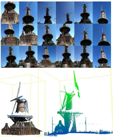
After cutting only the windmill from the original point cloud, the laser scanning point cloud -which can be scene in Figure 2 to-gether with the iPhone point cloud- consists of160,501points where each point has only(x, y, z)attributes.
The iPhone point cloud is generated using multi-view images taken by iPhone 3GS smartphone sensor. The algorithm starts by extracting local features of each input image, as introduced
This contribution has been peer-reviewed.
Figure 1: Left; Leica C10 laser scanner. Right; Point cloud obtained by the laser scanner. The red marker shows the scan station position.
by Lowe (2004). The smallest Euclidean distances between the descriptor vectors are considered for matching local features of overlapping input images. After local feature matching process, the relative rotation, translation and position matrices are calcu-lated and these matrices are used as input for the structure from motion (SfM) algorithm represented by Hartley (1993), in order to estimate the internal and external camera parameters. These are used for initializing the bundle adjustment algorithm which helps us by calculating the complete 3D point cloud. Figure 2 shows some of the input images and the resulting point cloud. In total50iPhone images are used for point cloud generation. The resulting point cloud consists of161,524points where each point is represented by(x, y, z, r, g, b)attributes.
Figure 2: Top; a collage of the sample iPhone images which are used for point cloud generation. Bottom; The point cloud
4 ASSESSMENT OF THE SMARTPHONE AND LASER
SCANNING POINT CLOUDS
In order to compare the smartphone based point cloud with the terrestrial laser scanning point cloud, the point clouds must be aligned. The major problem with smartphone based point clouds is that they are not calibrated. Their scale, rotation and location in 3D space does not show realistic information. On the other hand, our terrestrial laser scanning point cloud shows the 3D distance relationships of the scanned object sampling points in very high accuracy.
The alignment of smartphone point cloud on the laser scanning point cloud is performed in two steps; (1) a course re-scaling and alignment is performed by applying a transformation function to the smartphone point cloud, based on manual tie point selection between the smartphone and laser scanning point clouds, (2) Fine alignment of the smartphone point cloud on the laser scanning point cloud is performed using the Iterative Closest Points (ICP) approach.
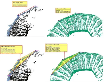
One challenge with the example structure is that, since it is a functioning windmill, its top mill rotates. Therefore, the time dif-ference between the smartphone point cloud generation and laser scanning, causes different positions of the moving parts. One part which is sure to be found stable in different data is the bal-cony of the windmill structure. Therefore, for the smartphone point cloud accuracy assessment, we compare the geometry of the point clouds only for the balcony area. Figure 3 shows the balcony of the smartphone point cloud and its fine alignment on the laser scanning point cloud.
In Figure 4, we show some screenshots of the 3D geometry com-parison of the smartphone and laser scanner point clouds. The top row shows the comparison of the 3D distance between the same reference points. A distance of4.489metersin the laser scan-ning point cloud is measured as4.317metersin the smartphone based point cloud based on the laser scanning point cloud mea-surements taken as reference. This shows that the measurement is done with3.8%error with smartphone. The bottom row of the Figure 4, shows that the balcony edge angle which is146.833 de-grees in laser scanning data is measured as149.345degrees in the smartphone point cloud. This shows that the angle measurement is done with1.7%error when smartphone is used. The results show the very low 3D geometrical error values of the smartphone based point cloud.
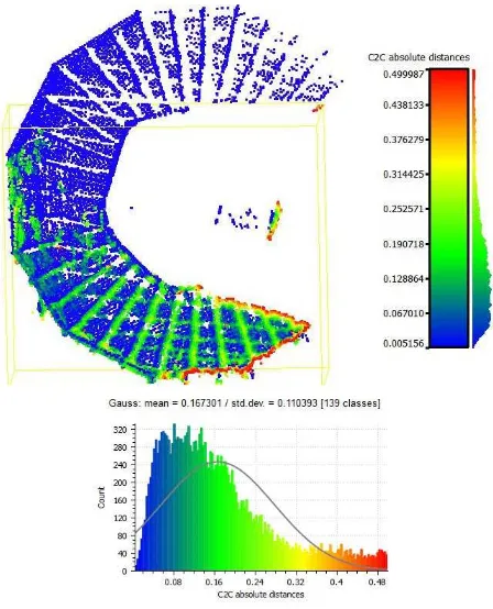
area of the two point clouds the error values (3D Euclidean dis-tance of the iPhone point cloud points to the closest laser scanning points) are computed. The error values and their histogram are represented in Figure 5 (based on comparison of 19163 points in the intersection area). Mean error of the smartphone based point cloud is calculated as0.16meters. This is mainly because of the thin line like structure details of the balcony which could not be modelled with smartphone.
Figure 5: Top; Error values are computed by comparing the distance of the iPhone point cloud points to the closest laser scanning points. Bottom; a histogram of the error values is
presented.
5 USING SMARTPHONE DATA FOR COLORING
LASER SCANNING POINT CLOUD
As we mentioned earlier, color registration to the laser scanning point clouds might require very long data acquisition time which is most of the time undesirable. For this reason, most of the time it is preferred to acquire point clouds without color information. However, coloring point clouds is very important for represent-ing realistic and more informative 3D renderrepresent-ing. In this point, smartphone point clouds might be very helpful to assign color in-formation to the laser scanning point clouds. To do so, herein we propose a new technique for coloring laser scanning point clouds based on smartphone data.
The point cloud coloring approach works as follows. For each point in the laser scanning point cloud, the closest three points of the smartphone point cloud is determined. The mean of red, green and blue attributes of these three smartphone point cloud are computed. Finally, they are assigned as attribute values to the laser scanning point sample. Figure 6 shows the laser scanning point cloud after its colored with smartphone data.
6 CONCLUSION
3D reconstruction of urban structures is crucial for many field such as 3D urban map generation, observing changes in three
Figure 6: Leica C10 laser scanner point cloud colored using smartphone data.
dimensions, developing 3D entertainment, engineering applica-tions, disaster preparation simulaapplica-tions, storing detailed informa-tion about cultural heritage. Point clouds are developing towards a standard product for 3D model reconstruction in urban man-agement field. Still, outdoor point cloud acquisition with active sensors is a relatively expensive and involved process. Genera-tion of point clouds using smartphone sensors could be a rapid, cheap and less involved alternative for local point cloud gener-ation, that could be applied for 3D archive updating. Besides, accuracy computation for practical point cloud generation, we present a method to add color information to existing point clouds with smartphone sensors.
ACKNOWLEDGEMENTS
We give thanks to the FP7 project IQmulus (FP7-ICT-2011-318787) ”A high volume fusion and analysis platform for geospatial point clouds, coverages and volumetric data set” for supporting Leica C10 laser scanning activities.
References
Bach, M. and Daniel, S., 2011. Towards a fast and easy approach for building textured 3D models using smartphones. In proceedings of ISPRS Joint Workshop on 3D City Modelling and Applications.
Baltsavias, E., 1999. A comparison between photogrammetry and laser scanning. ISPRS Journal of Photogrammetry and Remote Sensing54 (2), pp. 83–94.
Belongie, S. and Malik, J.and Puzicha, J., 2002. Shape matching and object recognition using shape contexts.IEEE Transactions on Pattern Analysis and Machine Intelligence24 (4), pp. 509–522.
datasheet, L. S. C., 2011. The all-in-one laser scanner for any application.
Leica Geosystems Product Datasheet.
Friedman, S. and Stamos, I., 2012. Online facade reconstruction from dominant frequencies in structured point clouds.IEEE Computer So-ciety Conference on Computer Vision and Pattern Recognition Work-shops (CVPRW)1, pp. 1–8.
Fritsch, D., Khosravani, A., Cefalu, A. and Wenzel, K., 2011. Multi-sensors and multiray reconstrcution for digital preservation. In Pro-ceedings of the Photogrammetric Week 20111, pp. 305–323.
Hartley, R., 1993. Euclidean reconstruction from uncalibrated views.in proceedings of the second European Workshop on Invariants, Ponta Delgada, Azores, Springer-Verlang1, pp. 187–202.
Heidari, A., Alaei Novin, I. and Aarabi, P., 2013. Fusion of spatial and visual information for object tracking on iphone. 2013 16th Interna-tional Conference on Information Fusion (FUSION)1, pp. 630–637.
Huttenlocher, D. and Ullman, S., 1990. Recognizing solid objects by alignment with an image.International Journal of Computer Vision5 (2), pp. 195–212.
This contribution has been peer-reviewed.
Huttenlocher, D., Klanderman, G. and Rucklidge, W., 1993. Comparing images using the hausdorff distance. IEEE Transactions on Pattern Analysis and Machine Intelligence15, pp. 850–863.
Klein, G. and Murray, D., 2009. Parallel tracking and mapping on a camera phone. In Proceedings of International Symposium on Mixed and Augmented Reality (ISMAR’09, Orlando).
Koch, R., Pollefeys, M. and van Gool L., 1998. Automatic 3d model acquisition from uncalibrated image sequences.Proceedings of Com-puter Graphics InternationalB1, pp. 597–604.
Laffont, P., Bousseau, A. and Drettakis, G., 2013. Rich intrinsic image decomposition of outdoor scenes from multi views.IEEE Transactions on Visualization and Computer Graphics19 (2), pp. 210–224.
Liu, L., Stamos, I., Yu, G., Wolberg, G. and Zokai, S., 2006. Multiview geometry for texture mapping 2d images onto 3d range data. in pro-ceedings of the 2006 IEEE Computer Society Conference on Computer Vision and Pattern Recognition1, pp. 2293–2300.
Lowe, D. G., 2004. Distinctive image features from scale-invariant key-points.International Journal on Computer Vision60(2), pp. 91–110.
Sirmacek, B., Shen, Y., Lindenbergh, R., Zlatanova, S. and Diakite, A., 2016. Comparison of zeb1 and leica c10 indoor laser scanning point clouds.XXIII ISPRS Congress, ISPRS Annals, Prague, Czech Repub-lic.
Thoeni, K., Giacomini, A., Murtagh, R. and Kniest, E., 2014. A com-parison of multi-view 3d reconstruction of a rock wall using several cameras and a laser scanner. ISPRS Technical Commision V Sympo-sium, Riva del Garda, ItalyXL-5, pp. 573–580.
Turner, E. and Zakhor, A., 2012. Sharp geometry reconstruction of build-ing facades usbuild-ing range data.19th IEEE International Conference on Image Processing, ICIP 2012, Lake Buena Vista, Orlando, FL, USA1, pp. 1785–1788.
Wang, S., 2012. Integrating sensors on a smartphone to generate tex-ture images of 3D photo-realistic building models.Proceedings of the Global Geospatial Conference 2012, Quebec City.
Figure 3: Left; balcony of the windmill from the smartphone point cloud. Middle and right; after fine alignment process on the laser scanning point cloud.
Figure 4: Top; measuring the distance between the same reference points based on iPhone and laser scanning point clouds respectively. Bottom; measuring the angle between two edges based on iPhone and laser scanning point clouds respectively.
This contribution has been peer-reviewed.