T
HE
O
PEN
G
EOSPATIAL
C
ONSORTIUM
(OGC®)
AND
R
EQUEST FOR
Q
UOTATION
&
C
ALL FOR
P
ARTICIPATION
FOR THE
A
RCTIC
S
PATIAL
D
ATA
P
ILOT
P
HASE
2
1
Introduction ... 3
1.1 Purpose ... 3
1.2 Background ... 3
1.3 The RFQ Documents and Pilot Process ... 5
1.4 Benefits to Sponsors and Pilot Participants ... 6
2
Context ... 6
2.1 Open Geospatial Consortium ... 6
2.2 Sponsor Objectives ... 6
2.3 Pilot Objectives ... 8
3
Master Schedule ... 8
OGC Arctic Pilot Request for Quotation – Main Body
Copyright © 2016 Open Geospatial Consortium 3
1
I
NTRODUCTION
1.1
P
URPOSEThe purpose of this Request for Quotation and Call for Participation (hereafter referred to as RFQ) is to solicit proposals in response to a set of requirements for the OGC Arctic Spatial Data Pilot
(ArcticSDP) Interoperability Program (IP) initiative.
The OGC, on behalf of the project sponsors, will provide cost-sharing funds to partially offset expenses uniquely associated with the initiative, thus the solicitation is for quotations from bidders wishing to receive cost-sharing. However, not all proposals are expected to seek cost-share funding. OGC intends to involve as many pilot participants in the initiative as possible; to the extent each pilot participant can enhance and/or contribute to the initiative outcomes.
1.2
B
ACKGROUNDUnderstanding and responding to the impacts of climate change and human activities in the Arctic, a unique area among the Earth’s ecosystems, require accessible and reliable data to facilitate monitoring, management, emergency preparedness and decision making. The Arctic region is home to indigenous communities and other residents, unique flora and fauna and this region is of great interest to the world as a result of their linkage to global climate systems, opportunities for economic development, geo-political strategic importance, and their environmental importance as well as sensitive ecosystems.
Arctic data are required by residents, the scientific community and other stakeholders to make informed decisions and support research on topics such as climate, atmosphere, land, oceans, ecosystems, ice and snow, permafrost, and social systems; and by the operations community to support impact assessments, engineering design, safe navigation and operations, risk management, emergency response, weather forecasting, and climate change adaptation. These activities contribute to environmental protection, heritage preservation, economic development, safety of life and property, or national sovereignty.
The polar data community1 is well organized and is pursuing activities to improve data management for all of the diverse members of the polar community. Polar data infrastructure is gradually evolving from a system where data are discovered in data catalogues and downloaded to the local machines of users, to a system of distributed data made interoperable using standards and providing users with storage and computational capacity close to large repositories of data. Currently, the opportunities for data exploration and usage based on interoperable Web service components are not fully exploited. The reasons are multiple, including sub-optimal design of available components, lack of sufficient metadata to discover relevant datasets, or the user community’s change from established workflows using locally stored data to online environments where data is provided at runtime from online Web services. It is the goal of this Arctic Spatial Data Pilot to demonstrate the
1
power and efficiency of distributed online environments for the exchange of geospatial Arctic data. It shall be demonstrated that a software architecture featuring distributed online Web services using open standards allows for an efficient and powerful working environment that supports processing, visualization, and representation of Arctic data in distributed systems. At the same time, this pilot helps gathering further insights into experienced obstacles and difficulties while using available systems to foster system-wide improvements and adaptations to specific users’ needs.
The Arctic Spatial Data Pilot (ArcticSDP) is an initiative by the Open Geospatial Consortium (OGC) sponsored by the US Geological Survey (USGS) and Natural Resources Canada (NRCan), in collaboration with the Arctic Spatial Data Infrastructure (Arctic SDI) Participants. The goal of the ArcticSDP phase 2 is to demonstrate the value of open standards and the capabilities of open distributed software architectures to exchange Arctic data to a broad range of stakeholders. Together with the results from phase-1, the Arctic Spatial Data Pilot will:
• inform the Data and Technical Interoperability Objective of the Arctic SDI Strategic Plan 2015-20202 and showcase for the world the value of shared and integrated services being delivered into an SDI;
• support Canada’s and US’ national priorities for national SDI implementation, evolution and development;
• define a standards based architecture for SDI in the Arctic. The architecture will be demonstrated during the pilot. The architecture and associated standards will be suitable to inform future procurements and developments of SDI in the Arctic.
• help stakeholders gain new perspectives into social, economic, and environmental issues by documenting an online network of resources that improve the sharing, use, and integration of information tied to geographic locations;
• contribute to the understanding of the complex web of stakeholders, SDI architectural approaches, software components, governance settings, and operational guidelines;
• further inform the future of pan-Arctic science, monitoring, and societal, economic, and environmental decision support; and
• help, in a reciprocal process, to generate a better understanding of how national spatial data infrastructures can be developed and applied to support international Arctic priorities, and to potentially showcase for the world the “system of systems” approach for data management across distributed SDIs.
The ArcticSDP is complemented by an ‘SDI for the Arctic’ thread that is part of the current OGC interoperability program activity Testbed-12 (http://www.opengeospatial.org/testbed12).
The Arctic Spatial Data Pilot is organized in two phases. This first phase - Concept Development - which ended March 2016, collected input on core components of an SDI, including an inventory of available geospatial Web service platforms across the Arctic region in general. The geographical
2
OGC Arctic Pilot Request for Quotation – Main Body
Copyright © 2016 Open Geospatial Consortium 5 focus in phase-1 was North America’s Arctic. Phase-1 included a Request for Information (RFI), which was issued earlier this year. Responses to the RFI were incorporated into the ArcticSDP Phase-1 report, published online and serve as an additional resource of information for responders to this RFQ. The second phase of the ArcticSDP – the Pilot deployment phase - starts with this RFQ and ends with final demonstrations planned for March 2017. The geographical region of interest has been broadened to the entire Arctic in phase-2, though to allow rich data integration demonstrations, the pilot demonstrations are to cover North America’s Arctic and other Arctic regions as available data allows.
The ArcticSDP Phase-1 report provides additional insights into a Spatial Data Infrastructure. It is recommended to consult this report prior to submitting a response to this RFQ. The report is available online at http://www.opengeospatial.org/projects/initiatives/arcticsdp.
The RFQ development has been supported by the Conservation of Arctic Flora and Fauna (CAFF), the biodiversity working group of the Arctic Council. This Arctic Spatial Data Pilot has been designed to fully support the Arctic SDI Strategic Plan.
1.3
T
HERFQ
D
OCUMENTS ANDP
ILOTP
ROCESSThe Arctic Spatial Data Pilot Management team, consisting of Sponsors and OGC personnel, has developed this RFQ to describe the requirements and architecture; and deliverables, schedule, and concept of operations, including communications plans organized in the following structure:
• RFQ Main Body (this document)
• RFQ Annex B: Technical Architecture and Deliverables
• RFQ Annex C: Participation in the pilot
o Initiative activities and roles
o Proposal submission instructions
o Evaluation process and criteria
o Kick-off and demonstration workshop requirements
o Communication and reporting requirements
• OGC ArcticSDP RFQ Response Template.docx: MS Word document to be used to respond to
this RFQ
• OGC ArcticSDP RFQ Finance Spreadsheet.xlsx: MS Excel spreadsheet to be used to respond
to this RFQ
1.4
B
ENEFITS TOS
PONSORS ANDP
ILOTP
ARTICIPANTSThe Arctic Spatial Data Pilot offers a prime opportunity to be at the forefront of the technological advancement and guide the standards process to achieve more and effective interoperability. Pilot participants will be first to market with relevant tools needed for by the Arctic community and showcase their tools to a wide market. The pilot participants also have the ability to help shape the direction of possible future changes of current standards in collaboration with the Sponsors. The Pilot will demonstrate and enhance the ability to exchange geospatial Arctic data and helps both pilot participants and Sponsors to gain new perspectives into social, economic, and environmental issues by providing an online network of resources that improves the sharing, use and integration of information tied to geographic locations in the North. The Arctic Spatial Data Pilot further allows pan-Arctic science, monitoring, and societal, economic, and environmental decision support. In a reciprocal process, developing the Arctic Spatial Data Pilot helps to generate a better understanding of how national spatial data infrastructures as well as international approaches such as the Arctic SDI or GEOSS can be developed and applied to support Arctic priorities. By implementing consistent means to share geographic data among all users, Sponsors costs for collecting and using data can be significantly reduced while decision-making is enhanced. Sponsors also reap the benefit of the ability to leverage other Sponsors funding in the Pilot, to assist in working towards the common goal.
Results from this initiative will be documented in an Engineering Report (ER) in the context of a hands-on engineering experience and illustrated in a series of videos. This initiative is aimed to develop, test, identify gaps and demonstrate the use of involved geospatial standards-based technologies in real world-type use cases.
2
C
ONTEXT
2.1
O
PENG
EOSPATIALC
ONSORTIUMThe primary purpose of OGC’s Interoperability Program is to bring Sponsors and industry Participants together in rapid, hands-on, collaborative engineering efforts to advance the development and use of OGC standards for open geospatial interoperability.
A Pilot in the OGC Interoperability Program is a collaborative effort that applies technology elements from the OGC Technical Baseline and other (non-OGC) technologies to Sponsor scenarios. In practice, a Pilot is where an OGC standard – or set of OGC standards and other industry standards – can be “stress tested” based on real-world application and experience.
This Project will involve research and development as well as refining and documenting specifications or enhancements; and for implementing prototype software that exercises existing or enhanced standards. The results of this project are directed at improving specifications, or providing profiles of existing standards rather than in creating new standards.
2.2
S
PONSORO
BJECTIVESOGC Arctic Pilot Request for Quotation – Main Body
Copyright © 2016 Open Geospatial Consortium 7
• Demonstrate the diversity, richness and value of SDI data-rich Web services to Arctic stakeholders for subsequent implementations and to influence Arctic Council information management practices, focusing on use cases that are directly relevant to Arctic Council Working Group priorities within the context of the Ninth Ministerial Meeting of the Arctic Council expressed in the Iqaluit Declaration 2015
• Demonstrate that geospatial data can be integrated from multiple sources efficiently into different clients using open standards developed by the OGC and other standardization organizations
• Implement and document the implementation process of use cases addressing particular needs (e.g. low to no bandwidth, high data production costs, rapid environmental changes) of the Arctic environment using new and existing components such as provided by the Arctic SDI or GEOSS
• Demonstrate polar projections supporting multiple views of Arctic data including on the fly re-projection (supporting EPSG 3571-3576)
• Demonstrate the value of metadata by comparing discovery and integration efforts for data and services with and without metadata
• Demonstrate the handling of real-time data (or least as close to real-time as possible) within Spatial Data Infrastructures
• Demonstrate how limited or no connectivity situations can be handled using offline packaging containers such as GeoPackage in combination with container provisioning services
• Demonstrate that the architecture can handle temporal data sets and sensor data
• Develop video material and further best practice documentation and presentation material that demonstrate all the functional requirements defined above
• Document the architecture that was developed and demonstrated in the pilot to support future procurements.
• Create an inventory of available Web services providing access to Arctic data
2.3
P
ILOTO
BJECTIVESIt is the goal of this Arctic Spatial Data Pilot to demonstrate the power, efficiency, and value of distributed, standards-based3 online environments for the exchange of geospatial Arctic data. It shall be demonstrated that a software architecture featuring distributed online Web services using open standards allows for an efficient and powerful working environment that supports processing, visualization, and representation of Arctic data in distributed systems. At the same time, this pilot helps gathering further insights into experienced obstacles and difficulties while using available systems to foster system-wide improvements and adaptations to specific users’ needs.
3
M
ASTER
S
CHEDULE
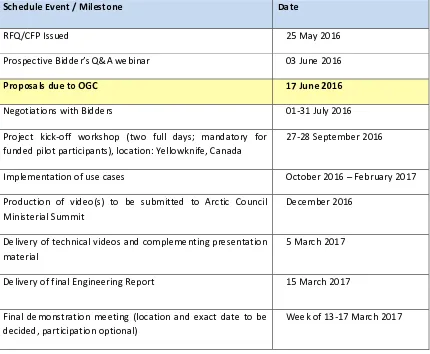
The following table details key events and activities associated with this RFQ:
TABLE 1, ARCTIC SPATIAL DATA PILOT MASTER SCHEDULE
Schedule Event / Milestone Date
RFQ/CFP Issued 25 May 2016
Prospective Bidder’s Q&A webinar 03 June 2016
Proposals due to OGC 17 June 2016
Negotiations with Bidders 01-31 July 2016
Project kick-off workshop (two full days; mandatory for funded pilot participants), location: Yellowknife, Canada
27-28 September 2016
Implementation of use cases October 2016 – February 2017
Production of video(s) to be submitted to Arctic Council Ministerial Summit
December 2016
Delivery of technical videos and complementing presentation material
5 March 2017
Delivery of final Engineering Report 15 March 2017
Final demonstration meeting (location and exact date to be decided, participation optional)
Week of 13-17 March 2017
3