@2011 Puslit Geoteknologi
Lembaga Ilmu Pengetahuan Indonesia 1
TRANSPORT AND TRANSFORMATION OF CHEMICAL
COMPONENTS IN THE GROUNDWATER FLOW SYSTEM OF
JAKARTA METROPOLITAN AREA
Mitsuyo Saito, Shin-ichi Onodera, Yu Umezawa, Takahiro Hosono, Yuta
Shimizu, Robert M. Delinom, Rachmat Fajar Lubis and Makoto Taniguchi
ABSTRACT The aim of this study is to examine the transport and transformation of chemical components within the groundwater flow in Jakarta area, and to evaluate the effects of accelerated urbanization on it. The collected data showed that the current hydraulic potential in the Jakarta metropolitan area is below sea level because of prior excess abstraction of groundwater.
Naskah masuk : 3 Januari 2011 Naskah diterima : 20 April 2011
Mitsuyo Saito
Center for Marine Environmental Studies, Ehime University, Japan
Email : [email protected] Shin-ichi Onodera
Graduate School of Integrated Arts and Sciences, Hiroshima University, Japan
Email: [email protected] Yu Umezawa
Faculty of Fisheries, Nagasaki University, Japan Email: [email protected]
Takahiro Hosono
Priority Organization for Innovation and Excellence, Kumamoto University, Japan
Email: [email protected] Yuta Shimizu
Graduate School of Integrated Arts and Sciences, Hiroshima University, Japan
Email: [email protected] Robert M. Delinom
Research Center for Geotechnology, Indonesian Institute of Sciences, Bandung 40135
Email: [email protected] Rachmat Fajar Lubis
Research Center for Geotechnology, Indonesian Institute of Sciences, Bandung 40135
Email: [email protected] Makoto Taniguchi
Research Institute for Humanity and Nature, Japan Email : [email protected]
The distribution of Cl- and Mn2- concentration in groundwater suggests that the decline in hydraulic potential has caused the intrusion of seawater to shallow groundwater and the movement of shallow groundwater into deep groundwater. It implies an accumulation of contaminants in deep aquifers. On the other hands, the presentation of NO3
--N in groundwater is suggested to be attenuated by the processes of denitrification and dilution in the coastal area.
Keywords: groundwater flow, chemical
components, transport, transformation, urbanization, Jakarta
ABSTRAK Tujuan dari penelitian ini adalah untuk menentukan perjalanan dan perubahan dari zat kimia dalam aliran airtanah di Cekungan Jakarta dan untuk mengevaluasi dampak dari percepatan urbanisasi di daerah tersebut. Data yang dianalisis menunjukkan bahwa potensi hidraulik airtanah yang teramati telah berada di bawah permukaan laut karena pengambilan airtanah yang berlebihan. Distribusi dari konsentrasi Cl- dan Mn2- dalam airtanah memberikan kesan bahwa penurunan potensial hidrolik telah menyebabkan intrusi airlaut terhadap airtanah dangkal dan menyebabkan pergerakan airtanah dangkal ke airtanah yang lebih dalam. Hal ini secara tidak langsung memperlihatkan adanya akumulasi dari kontaminan dalam akifer airtanah dalam. Dengan kata lain, kehadiran NO3—N dalam
airtanah diperkirakan akan menjadi sedikit dengan adanya proses denitrifikasi dan dilusi di daerah pantai.
Kata kunci: aliran airtanah, unsur kimia,
2
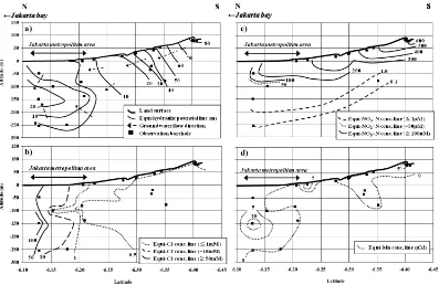
Figure 1 Study area (a) and location of the sampling wells (b).
INTRODUCTION
For the sustainable use of groundwater resources in the future, it is important to conserve its quality as well as quantity. The population of Asia has increased rapidly over the last three decades. In 1995, there were more than five megacities with populations >10 million emerged in Asia (Jiang et al., 2001). Especially in the developing megacities, land subsidence and groundwater pollution by several contaminants (e.g. nitrate, trace metals and organic pollutants etc.) is one of a severe environmental problems, due to the intensive extraction of groundwater and huge amount of contaminant load derived from domestic wastewater as well as agricultural and industrial wastewater (Shindo et al., 2006; Onodera et al., 2009; Umezawa et al., 2009; Hosono et al., 2011). In Tokyo and Osaka, groundwater was used as a water resource during the period of rapid population increase before 1970, and consequently groundwater resources have been degraded (Environment Agency Japan, 1996). To use groundwater in a sustainable manner in developing megacities such as Jakarta, it will be important to conserve groundwater quality and quantity based on the experience gained earlier in Tokyo and Osaka. However, the process of groundwater degradation, including
depletion and contamination, has not been confirmed well in these developing megacities.
The objective of the study is to confirm the transport and transformation of chemical components within groundwater flow in Jakarta area, and to clarify the effect of urbanization on it.
STUDY AREA
Jakarta located on the lowlands of the northern coast of West Java province in Indonesia (Fig. 1a), and it has been one of the Asian megacities from early 2000s. The current population is approximately 12 million. The average annual temperature is 27°C and the annual rainfall is 2000 mm. Land subsidence occurs with the rates of 1-10 cm/year (Abidin et al., 2007) due to the large magnitude of groundwater pumping. In Jakarta, the agricultural area distributes about 40% of the total area. It suggests large nitrogen load by fertilizer application (Umezawa et al., 2009). The study area covered the groundwater basin including the metropolitan area of Jakarta (Fig. 1b).
@2011 Puslit Geoteknologi
Lembaga Ilmu Pengetahuan Indonesia 3 Figure 2 Distributions of (a) hydraulic potential, (b) Cl- concentration, (c) NO3--N concentration and
(d) Mn concentration in the N-S cross section in Fig.1b. marine Pliocene and Quaternary sand and delta
sediments up to 300 m thick. Quaternary deposits may be conveniently divided into three aquifer systems on the basis of hydraulic characteristics and depth: the Phreatic Aquifer System (0 to -40 m), the Upper Confined Aquifer System (--40 to -140 m), and the Lower Confined Aquifer System (deeper than -140 m). Around the Jakarta metropolitan area, the average horizontal hydraulic conductivity is approx. 1.0×10⁻³ cm/s, and the vertical value about 1.0×10⁻⁵ cm/s, respectively.
METHODS
The field studies were performed in the groundwater basin including metropolitan areas (Fig. 1b). Groundwater level measurements and
water sampling were performed at the beginning of the rainy season in study areas at selected boreholes during September 2006. In Jakarta, water samples were collected from 33 shallow production wells and 20 observation wells with depths of 50 to 200 m. Sampling from the observation wells and production wells was performed using a bailer sampler and a water pump, respectively. Electrical conductivity (EC), pH, and dissolved oxygen (DO) concentrations were measured in the field.
Water samples were analyzed for concentrations of Cl- and NO3
by ion chromatography (HIC-NS; Shimadzu, Kyoto, Japan). Concentration of Mn was analyzed by ICP-AES (Optima3000;
4
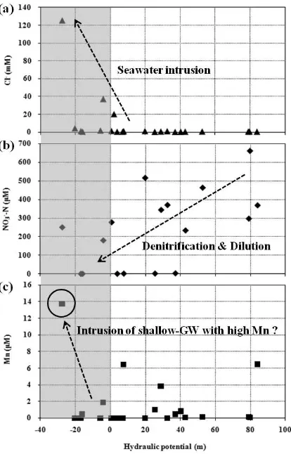
Figure 3 Relation between hydraulic potential and (a) Cl-, (b) NO3
--N and (c) Mn concentrations in groundwater (*shaded are means hydraulic potential is below sea level).
RESULTS & DISCUSSION
Groundwater flow condition
The distribution of hydraulic potential is shown in Figure 2a. It indicates the direction of overall horizontal groundwater flow is from the mountainside to Jakarta Bay (south to north). However, the direction of vertical flow was downward in the relatively shallow groundwater at depths of <50 m from the ground surface, whereas it was upward in the deep groundwater at depths of >200 m around the Jakarta metropolitan area. This suggests that the hydraulic potential of shallow groundwater has declined because of excess pumping of groundwater in this area. Onodera et al. (2009)
pointed out the intrusion of shallow groundwater to the deep groundwater in the metropolitan area. The horizontal hydraulic gradient is estimated to be approximately 0.05 and darcy flux is 5.1×10⁻⁵ cm/s in the mountainside (groundwater recharge area).
Transport and transformation of chemical components with groundwater flow
@2011 Puslit Geoteknologi
Lembaga Ilmu Pengetahuan Indonesia 5 has caused the intrusion of seawater in the
coastal area, and shallow groundwater into deep groundwater. Nitrate-nitrogen (NO3--N) con-centrations in the groundwater are shown in figure 2c. It was more than 600 μM-1 in the relatively shallow groundwater of the mountainside at depths of <100 m. However it caused by the denitrification and dilution process in the coastal area. The distribution of Mn concentration in groundwater on the north-south transect in Jakarta is shown in figure 2d. The concentration was highest at the coastal area, at > 10 μM at a depth of -150 m. The hydraulic potential was lowest at this point. These observations suggest that the high Mn concentration was caused by the intrusion of both shallow groundwater and deep groundwater.
These results suggest that the decline in hydraulic potential has caused the intrusion of seawater and shallow groundwater into the deep groundwater (Fig.3). It implies that Cl- and Mn will be accumulated in deep aquifer, whereas NO3
--N will be attenuated before reaching the sea (Jakarta bay).
CONCLUSION
The current condition of groundwater flow and distribution of chemical components were confirmed, and the effect of urbanization on it was examined on the groundwater of Jakarta metropolitan area. The results show that hydraulic potential of shallow groundwater has declined because of excess pumping of groundwater in this area. It has also caused the intrusion of seawater into shallow groundwater and in some reasons flow to the deep groundwater, and transport and accumulation of Cl- and Mn to deep aquifer. Meanwhile, NO3
--N is suggested to be attenuated by the processes of denitrification and dilution with the groundwater flow.
ACKNOWLEDGMENT
We thank the staffs and students of the Indonesia Institute of Science (LIPI) for support with water sampling and processing. This research was
supported financially by the project “Human Impacts on Urban Subsurface Environment” of
the Research Institute for Humanity and Nature (RIHN).
REFERENCES
Abidin H. Z., Andreas H., Djaja R., Darmawan D., and Gamal M. (2007). Land subsidence characteristics of Jakarta between 1997 and 2005, as estimated using GPS surveys. GPS SOLUTIONS, DOI: 10.1007/s10291-007-0061-0.
Djaja R., RaisJ., Abidin H. Z., and Wedyanto K. (2004). Land subsidence of Jakarta metropolitan area. In: The 3rd FIG Regional Conference (Jakarta, Indonesia, October 3– 7).
Environment Agency Japan (1996). White Paper: Quality of the Environment in Japan, Printing Bureau, Ministry of Finance Japan. Hosono T., Nakano T., Shimizu Y., Onodera S.,
and Taniguchi M. (2011). Hydrogeological constraint on nitrate and arsenic contamination in Asian metropolitan groundwater. Hydrological Processes, DOI: 10.1002/hyp.8015.
Jiang Y., Kirkman H., and Hua A. (2001). Megacity development: managing impacts on marine environments. Ocean and Coastal Management, 44, 293–318. Onodera S., Saito M., Sawano M., Hosono T.,
6
Saito M., Onodera S., Umezawa Y., Hosono T., Shimizu Y., Delinom R., and Taniguchi M. (2009). Evaluation of nitrate attenuation potential in the groundwater of Jakarta metropolitan area, Indonesia. IAHS Publication, 329, 305-310.
Shindo J., Okamoto K., and Kawashima H. (2006). Predidction of the environmental effects of excess nitrogen caused by increasing food demand with rapid economic growth in eastern Asian
countries, 1961-2020. Ecological Modeling, 193, 703-720.