Published by Canadian Center of Science and Education
19
Health Risk Implications of Terrestrial Gamma Radiation Dose Rate in
Central Jakarta, Indonesia: Short Communications
Nursama Heru Apriantoro1, Muzilman Muslim2, Dadong Iskandar3, Purwantiningsih2, Witri Mulyani2 & Samsun1 1
Department of Radiodiagnostic and Radiotherapy, Politeknik Kesehatan Kemenkes Jakarta II, Indonesia 2
Department of Physics, Faculty of Technique and Science, Universitas Nasional, Jakarta Indonesia 3
Center for Technology of Radiation Safety and Metrology, National Nuclear Energy Agency Jakarta, Indonesia Correspondence: Nursama Heru Apriantoro, Department of Radiodiagnostic and radiotherapy, Politeknik Kesehatan Kemenkes Jakarta 2, Hang Jebat III/F-3, Jakarta 12120, Indonesia. Tel/Fax: 62-21-720-6239. E-mail: [email protected]
Received: August 28, 2017 Accepted: September 19, 2017 Online Published: September 25, 2017 doi:10.5539/gjhs.v9n12p19 URL: https://doi.org/10.5539/gjhs.v9n12p19
Abstract
Terrestrial gamma radiation (TGR) dose rate measurement has been conducted around downtown region of Central Jakarta Indonesia. The real time count data was taken 1 m above the ground in eight sub district locations by using a portable gamma Survey meter of Exploranium GR-135 Plus Model. The reading position was determined by Garmin GPSMAP 62s. The average value of TGR dose rate of (47.76 ± 18.24) nSv h-1 ranged from 6.40 nSv h-1 to 120.90 nSv-1, it is higher than in Indonesia average. The annual effective dose rate of 0.06 mSv contributes to fatal cancer risk of about 3.32 x 10⁻⁶ per year for each individual in Central Jakarta. For the subdistrict TGR dose rate value was varied, however all the result is not high enough to cause for alarm.
Keywords: terrestrial gamma radiation, health risks, dose assessment, Central Jakarta 1. Introduction
Background Radiation surveys were conducted in many countries around the world to establish a baseline level of natural radiation (Al-Sharkawy et al., 2012; Songs et al., 2012; Dent et al., 2013; Krishnamoorthy et al., 2013; Muntean et al., 2013; Mykowska & Hupka, 2014; Garba et al., 2014; Todorovic et al., 2014; Liu et al., 2015; Ramli et al., 2016). Background terrestrial gamma radiation dose rate is influenced by primordial radioactive concentration such as uranium, thorium and potassium (Apriantoro et al., 2013; Mohapatra et al., 2013; Krishnamoorthy et al., 2013; Sánchez-González et al., 2014; Karataşlı et al., 2016).
The annual effective dose values for terrestrial gamma radiation dose rate of 0.48 mSv with indoor and outdoor are 0.41 mSv and 0.07 mSv respectively (UNSCEAR, 2010). The abnormally high terrestrial gamma radiation in the world was found in Brazil, it is due to the presence of monazite sand along the Atlantic coast and volcanic intrusion in the Minas Gerias State. Dose rate in this area ranged up to 2.1 Gy h-1 (Roser & Cullen, 1964; The Brazilian Academy of Science, 1977). In Indonesia the mean of terrestrial gamma radiation dose rate is 40 nGy h-1 ( 40 nSv h-1)with range of 23.9 nGy.h-1 to 40.1 nGy h-1, and the high radiation dose rate was found in Bangka Island and Karimu Island, average dose rate in this area of 330 nGy h-1 and 310 nGy h-1 respectively (UNSCEAR, 2010). The main purpose for the study is to determine the base line data of natural radiological background in downtown of Indonesia and its health implication.
2. Study Area
20
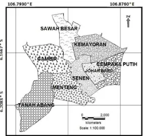
Figure 1.Map of Central Jakarta Region as GIS software
Central Jakarta is underlied by three geological formations, they are alluvial, beach ridge deposits and alluvial fan deposits (Geological Research and Development Center, 1992). Rock formation consists of clay, silt, sand, gravel, and lump. In this area, a coastal region is composed of sedimentary rock like formation consisting coast of coarse sand, shell and molluks. The Central Jakarta is overlaid by the differences soiltype of aquepts (endoaquepts, dystrudeptsaquic, andhalaquepts) and dystrudepts (Indonesia Center for Research and Development of Agricultural Land Resources, 2014).
3. Materials and Methods
3.1 Terrestrial Gamma Radiation (TGR) Dose Rates
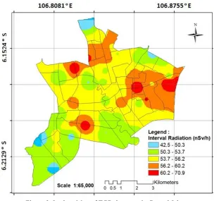
The sampling points were determined randomly based on topography in 59 grid line positions for every 1 km2 as shown in Figure 2. The Sampling points were taken about 1 km distance along the longitudinal and latitudinal in eight sub district regions. The geographic coordinates information was determined using a global positioning system (GPS) hardware by Garmin GPSMAP 62s. The detector to collect data was manufactured byExploranium GR-135 Plus, ModelGR-135ND-H. It quickly and accurately detects and identifies gamma and neutron sources in the field (Leidos, 2017). It was calibrated by the National Atomic Energy Agency, it is a Secondary Standard Dosimetry Laboratory (SSDL).Measurements of terrestrial gamma radiation dose rates surveys were conducted from September 2016 to January 2017.
3.2 Estimation of Annual Effective Dose Rate
Using the conversion coefficient factors for absorbed dose in air to effective dose of 0.7 Sv Gy-1 as recommended by UNSCEAR 2000, the annual effective dose (HE) was calculated by using equation 1
HE = Effective dose rate per an hour (nSv/h) 24 h 365 days OF 0.7 10-6 (1) Where HE is annual effective dose in mSv, and OF Occupancy Factor that is 20% for outdoor activities.
3.3 Estimation of Health Risks
To estimate the risk of fatal cancer for the population, Equation (2) below is used (Alvarez, 1997; Ramli et al., 2009):
21
Figure 2. Grid positions where TGR dose rate were taken
3.3 Estimating of Dose Distribution Map
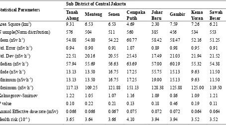
Estimating for dose distribution was shown by Isodose Map which adopted using GIS Applications (Sanusi et al., 2014; Ramli et al., 2016). A inverse distance squared interpolation method was employed to convert the TGR dose rate at each point. Figure 3. Shown the TGR dose rate distribution map in Central Jakarta.
Figure 3. Isodose Map of TGR dose rate in Central Jakarta
4. Results and Discussion
22
the data was created to be normal distribution. the Kolmogorov-Smirnov value for each sub district is higher than 0.05, it may be assumed that the data have a normal. The high annual effective dose rate at sub district in Central Jakarta are in Cempaka Putih, Johar Baru and Gambir. The average value in that area is higher than the world average of 0.07 mSv. It contributes to health risk implication of about 3.85 x 10⁻⁶ per year.
Table 1. Statistical analysis of TGR dose from different Sub district of Central Jakarta
Statistical Parameters
Maximum (nSv h-1) 117.13 109.25 121.88 151.13 128.38 125.88 125.00 119.50
Kolmogorov-Smirnov 1.22 1.05 1.07 1.16 1.09 0.86 1.09 1.21
P value 0.10 0.22 0.21 0.13 0.18 0.46 0.19 0.11
Annual Effective dose rate (mSv) 0.066 0.066 0.067 0.075 0.072 0.072 0.064 0.064
Health risk (10-6 ) 3.65 3.64 3.66 4.10 3.94 3.94 3.52 3.52
In overall from 3,481 data which the distribution is normal, the average value of TGR dose rate is (47.76 ± 18.24) nSv h-1 ranged from 6.40 nSv h-1 to 120.90 nSv-1.It was higher than Indonesia average of 40 nSv h-1 as reported by UNSCEAR 2010. The annual effective dose rate for outdoor activities was calculated of 0.06 mSv.
The TGR dose rate results of Central Jakarta are not influenced by geological features and soil type background because it is not igneous rock or granite. The study area is located in downtown that predominantly disturbed land under commercial and vacant development, with concrete house, apartment, roads and drainage system were constructed. The high reading obtained in the study probably derived from the road in which its materials consists of sand, cement, rock and asphalt. The road materials mostly come from the other area outside Jakarta. They could be from the volcano material after the eruption such as Merapi of Central Java and Galanggung of West Java. However the annual effective dose rate for outdoor activities of 0.06 mSv is lower than world wide average of 0.07 mSv. It contributes to health risk implication, about 3.32 x 10⁻⁶per year. It means that about 1 in every 279,330 people in Central Jakarta might be at risk of cancer from terrestrial gamma radiation dose rate .
5. Conclusion
The average of natural terrestrial gamma radiation dose rate in Central Jakarta is approximately higher than the average value of Indonesia. However the population does not receive the background radiation exposure which is relatively high.The annual effective dose rate of 0.06 mSv contributes to fatal cancer risk about 3.32 x 10⁻⁶ per year which is not high enough to cause for alarm.
The study should be continued to know the TGR dose rate effect of soil, water, radon and toron to health risk implications in the area.
Acknowledgements
We are sincerely grateful to The Center for Technology of Radiation Safety and Metrology, National Nuclear Energy Agency Jakarta, Indonesia for their valuable contributions and facilities during the study.
Competing Interests Statement
23 References
Al-Sharkawy, A., Hiekal, M. T., Sherif, M. I., & Badran, H. M. (2012).An environmental assessment of the level of gamma-radiation stream sediments around Sharm El-Sheikh, South Sinai, Egypt. J. Environ. Radioact., 112, 76-82. https://doi.org/10.1016/j.jenvrad.2012.05.020
Alvarez, J. L. (1997). Ionizing Radiation Risk Assessment. In Molak, V. (eds.), Fundamentals of Risk Analysis and Risk Management (p. 163-175).CRC Press.
Apriantoro, N. H., Ramli, A. T., & Sutisna. (2013).Activity Concentration of 238U, 232Th and 40K Based on Soil Types in Perak State, Malaysia. Earth ScienceResearch, 2(2), 122-127. https://doi.org/10.5539/esr.v2n2p122
BPS Jakarta. Central Bureau of Statistics Jakarta. (2017). Period of Population and Population Growth Rate by Regency/City in Jakarta in 2010, 2014, and 2015. Retrieved February 12, 2017, from https://jakarta.bps.go.id/linkTabelStatis/view/id/136
Brazillian Academy of Sciences. (1997). International Symposium on High-Region Natural Radioactivity. Acad. Brasil de Cienciased.
Dent, D. L., MacMillan, R. A., Mayr, T. L., Chapman, W. K., & Berch, S. M. (2013). Use of Airborne Gamma Summing radiometrics for Real Property for Forested Area in British Columbia, Canada. Journal of Ecosystems and Management, 14(1).
Garba, N. N., Ramli, A. T., Saleh, M. A., Sanusi, M. S., & Gabdo, H. T. (2014). Terrestrial gamma dose rate radiation and radiological mapping of Terengganu State, Malaysia. J. Radioanal. Nucl. Chem, 303(3), 1785-1792. https://doi.org/10.1007/s10967-014-3818-2
Geological Research and Development Center. (1992). Geologic Map of Jakarta and the Thousand Islands, Java.
ICRP. (2007).The 2007 Recommendations of the International Commission on Radiological Protection. ICRP publication, 103.
Indonesia Center for Research and Development of Agricultural Land Resources (2014). Land Resources Review the level of West Java and Jakarta.
Karataşlı, M., Turhan, Ş., Varinlioğlu, A., &Yeğingil, Z. (2016). Natural and the falloutradioactivity level and radiation hazard in soil samples. Environ Earth Sci., 75, 424. https://doi.org/10.1007/s12665-016-5414-y
KODIM JP. (2017, February). Topography Overview Central Jakarta.Retrieved fromhttp://kodimjakpus.insannusantara.com/?page_id=199
Krishnamoorthy, N., Mullainathan, S., & Murugesan, S. (2013). Evaluation of natural radioactivity in rocks Nilgiri hills and radiation hazard to humans. International Journal of Low Radiation, 9(1), 30-37. https://doi.org/10.1504/IJLR.2013.054172
Leidos. (2017, July). ExploraniumGR-135 Plus "Identifier" Radioisotope Identification Device. Retrieved from https://www.leidos.com/products/security/gr-135
Liu, G., Luo, Q., Ding, M., & Feng, J. (2015). Natural radionuclides in soil near a coal fired power plant in the high background radiation area, South China. Environ. Monit. Assess., 187(6), 356. https://doi.org/10.1007/s10661-015-4501-y
Mohapatra, S., Sahoo, S., Kumar, A. V., Patra, A., Lenka, P., Dubey, J., … Puranik, V. (2013). Distribution norms and 137Cs in the soil of the region Visakhapatnam, East India, and the radiation dose related. Radiat. Prot. Dosimetr., 157(1), 95-104.https://doi.org/10.1093/rpd/nct108
Muntean, L. E., Cosma, C., & Moldovan, D. V. (2013).Measurement of natural radioactivity and radiation hazard to some natural and artificial building materials available in Romania. J. Radioanal. Nucl. Chem., 299(1), 523-532. https://doi.org/10.1007/s10967-013-2837-8
Mykowska, A., & Hupka, J. (2014). Radionuclides Activity and Effective Dose referred Geologic Formations.
Journal of Intelligent Industry and Information, 2(4). https://doi.org/10.12720 / jiii.2.4.284-288
Ramli, A. T., Apriantoro, N. H., Heryansyah, A., Basri, N. A., Sanusi. M. S., & Abu Hanifah, N. Z. (2016).. Predicting terrestrial gamma dose rate based on geological and soil information: case study of Perak state, Malaysia. J Radiol Prot., 36(1), 20-36. https://doi.org/10.1088/0952-4746/36/1/20
24
of Health Science, 1(2), 140-149.https://doi.org/10.5539/gjhs.v1n2p140
Roser, F. X., & Cullen, T. L. (1964). External Radiation Levels in High Background Region of Brazil. In Natural Radiation Environment. University of Chicago Press, III: 855-872
Sánchez-González, S., Curto, N., Caravantes, P., & García-Sánchez, A. (2014). Natural gamma radiation and the distribution of uranium in soil and water in the river basin Agueda (Spain-Portugal). Procedia Earth and Planetary Science, 8, 93-97.https://doi.org/10.1016/j.proeps.2014.05.019
Sanusi, M. S. M., Ramli, A. T., Gabdo, H. T., Garba, N. N., Heryansyah, A., Wagiran, H., & Said, M. N. (2014). Isodose mapping of terrestrial gamma radiation dose rate of Selangor state, Kuala Lumpur and Putrajaya, Malaysia. J. Environ. Radioact., 135, 67-74. https://doi.org/10.1016/j.jenvrad.2014.04.004
Songs, G., Chen, D., Tang, Z., Zhang, Z., & Xie, W. (2012).The level of natural radioactivity in the topsoil of the Pearl River Delta Zone, Guangdong, China. J Environ Radioact, 103(1), 48-53. https://doi.org/10.1016/j.jenvrad.2011.06.014
Todorovic, N., Bikit, I., Krmar, M., Mrdja, D., Hansman, J., Nikolov, J., … Jakonic, I. (2014). Natural radioactivity in raw materials used in the building industry in Serbia. International Journal of Environmental Science and Technology, 12(2), 705-716. https://doi.org/10.1007/s13762-013-0470-2
UNSCEAR. (2000). Sources and effects of ionizing radiation United Nation Scientific Committee on the Effects of Atomic Radiation Report to the General Assembly. United NationsNew York, USA.
UNSCEAR. (2010). Sources of Ionizing Radiation Effects of Volume 1.UNSCEAR 2008 Report to the General Assembly with Scientific Annexes. New York: United Nation.
Copyrights
Copyright for this article is retained by the author(s), with first publication rights granted to the journal.