Copyright © 2015 Open Geospatial Consortium. 1
Open Geospatial Consortium
Publication Date: 2015-03-26
Approval Date: 2014-12-05
Submitted Date: 2014-10-08
Reference number of this document: OGC 14-057
External identifier of this OGC® document: http://www.opengis.net/doc/PER/UKIAP2014
Category: Public Engineering Report
Editor(s): Bart De Lathouwer, Peter Cotroneo, Paul Lacey
OGC® and Ordnance Survey - UK Interoperability
Assessment Plugfest (UKIAP)
Engineering ReportCopyright © 2015 Open Geospatial Consortium.
To obtain additional rights of use, visit http://www.opengeospatial.org/legal/.
Warning
This document is not an OGC Standard. This document is an OGC Public
Engineering Report created as a deliverable in an OGC Interoperability Initiative and is not an official position of the OGC membership. It is distributed for review and comment. It is subject to change without notice and may not be referred to as an OGC Standard. Further, any OGC Engineering Report should not be referenced as required or mandatory technology in procurements.
Document type: OGC® Public Engineering Report
Document subtype: NA
Document stage: Approved for public release
Abstract
The Open Geospatial Consortium (OGC), the UK Ordnance Survey, AGI and Dstl conducted a first of a series of events called the United Kingdom Interoperability Assessment Plugfest (UKIAP) 2014. The purpose of UKIAP 2014 is to advance the interoperability of geospatial products and services based on OGC standards within the UK geospatial information (GI) community. The results of the Plugfest will allow Ordnance Survey to provide best practice guidance to those who want to consume or implement geospatial web services or products based on OGC standards. UKIAP 2014 is open to open- and closed source vendors and to all GI organizations in the UK to involve as many participants in the initiative as possible.
Keywords
License Agreement
Permission is hereby granted by the Open Geospatial Consortium, ("Licensor"), free of charge and subject to the terms set forth below, to any person obtaining a copy of this Intellectual Property and any associated documentation, to deal in the Intellectual Property without restriction (except as set forth below), including without limitation the rights to implement, use, copy, modify, merge, publish, distribute, and/or sublicense copies of the Intellectual Property, and to permit persons to whom the Intellectual Property is furnished to do so, provided that all copyright notices on the intellectual property are retained intact and that each person to whom the Intellectual Property is furnished agrees to the terms of this Agreement.
If you modify the Intellectual Property, all copies of the modified Intellectual Property must include, in addition to the above copyright notice, a notice that the Intellectual Property includes modifications that have not been approved or adopted by LICENSOR.
THIS LICENSE IS A COPYRIGHT LICENSE ONLY, AND DOES NOT CONVEY ANY RIGHTS UNDER ANY PATENTS THAT MAY BE IN FORCE ANYWHERE IN THE WORLD.
THE INTELLECTUAL PROPERTY IS PROVIDED "AS IS", WITHOUT WARRANTY OF ANY KIND, EXPRESS OR IMPLIED, INCLUDING BUT NOT LIMITED TO THE WARRANTIES OF MERCHANTABILITY, FITNESS FOR A PARTICULAR PURPOSE, AND NONINFRINGEMENT OF THIRD PARTY RIGHTS. THE COPYRIGHT HOLDER OR HOLDERS INCLUDED IN THIS NOTICE DO NOT WARRANT THAT THE FUNCTIONS CONTAINED IN THE INTELLECTUAL PROPERTY WILL MEET YOUR REQUIREMENTS OR THAT THE OPERATION OF THE INTELLECTUAL PROPERTY WILL BE
UNINTERRUPTED OR ERROR FREE. ANY USE OF THE INTELLECTUAL PROPERTY SHALL BE MADE ENTIRELY AT THE USER’S OWN RISK. IN NO EVENT SHALL THE COPYRIGHT HOLDER OR ANY CONTRIBUTOR OF
INTELLECTUAL PROPERTY RIGHTS TO THE INTELLECTUAL PROPERTY BE LIABLE FOR ANY CLAIM, OR ANY DIRECT, SPECIAL, INDIRECT OR CONSEQUENTIAL DAMAGES, OR ANY DAMAGES WHATSOEVER RESULTING FROM ANY ALLEGED INFRINGEMENT OR ANY LOSS OF USE, DATA OR PROFITS, WHETHER IN AN ACTION OF CONTRACT, NEGLIGENCE OR UNDER ANY OTHER LEGAL THEORY, ARISING OUT OF OR IN CONNECTION WITH THE IMPLEMENTATION, USE, COMMERCIALIZATION OR PERFORMANCE OF THIS INTELLECTUAL PROPERTY.
This license is effective until terminated. You may terminate it at any time by destroying the Intellectual Property together with all copies in any form. The license will also terminate if you fail to comply with any term or condition of this Agreement. Except as provided in the following sentence, no such termination of this license shall require the termination of any third party end-user sublicense to the Intellectual Property which is in force as of the date of notice of such termination. In addition, should the Intellectual Property, or the operation of the Intellectual Property, infringe, or in LICENSOR’s sole opinion be likely to infringe, any patent, copyright, trademark or other right of a third party, you agree that LICENSOR, in its sole discretion, may terminate this license without any compensation or liability to you, your licensees or any other party. You agree upon termination of any kind to destroy or cause to be destroyed the Intellectual Property together with all copies in any form, whether held by you or by any third party.
Except as contained in this notice, the name of LICENSOR or of any other holder of a copyright in all or part of the Intellectual Property shall not be used in advertising or otherwise to promote the sale, use or other dealings in this Intellectual Property without prior written authorization of LICENSOR or such copyright holder. LICENSOR is and shall at all times be the sole entity that may authorize you or any third party to use certification marks, trademarks or other special designations to indicate compliance with any LICENSOR standards or specifications.
This Agreement is governed by the laws of the Commonwealth of Massachusetts. The application to this Agreement of the United Nations Convention on Contracts for the International Sale of Goods is hereby expressly excluded. In the event any provision of this Agreement shall be deemed unenforceable, void or invalid, such provision shall be modified so as to make it valid and enforceable, and as so modified the entire Agreement shall remain in full force and effect. No decision, action or inaction by LICENSOR shall be construed to be a waiver of any rights or remedies available to it.
Contents
Page1 Introduction ... 6
1.1 Scope ... 6
1.2 The Open Geospatial Consortium ... 6
1.3 Ordnance Survey ... 7
1.4 Association of Geographic Information (AGI) ... 7
1.5 Defence Science and Technology Laboratory (Dstl) ... 7
1.6 Document contributor contact points ... 8
1.7 Revision history ... 8
4.1 Objectives of the Plugfest Sprint 2 ... 13
4.2 Plugfest Process, Activities, Procedures, and Artefacts ... 14
4.2.1 Scenarios ... 15
5 Summary of Recommendations and conclusion ... 38
6 Sprint 1 and Sprint 2 GML ... 41
6.1 Simple Features Profile in general (level 0) ... 41
6.1.1 Geometry / spatial property types ... 41
6.1.2 Coordinate space ... 43
6.1.3 Spatial reference system ... 43
6.1.3.1 Referencing the srsName ... 44
6.1.3.2 Recognising spatial reference systems ... 44
6.1.4 Schema design ... 45
6.1.5 Measures ... 45
6.1.6 Code lists and dictionaries ... 46
6.2 Simple Features Profile compliance level 1 ... 46
6.2.1 User defined property types ... 46
6.2.2 Use of nillable and xsi:nil ... 47
6.2.3 Maximum multiplicity > 1 ... 47
6.3 Aspects of GML 3.3 ... 47
6.3.1 LanguageStringType ... 47
6.3.3 Reference data ... 47
6.3.3.1 OS VectorMap District ... 47
6.3.3.2 OS Terrain 5, OS Terrain 50 vector ... 48
6.3.3.3 OS MasterMap Sites Layer ... 48
7 OS Terrain: Coverages ... 50
7.1 OS Terrain: Vector Elements ... 51
7.2 OS MasterMap Site Layer ... 52
OGC® and Ordnance Survey
- UK Interoperability
Assessment Plugfest (UKIAP) Engineering Report
1 Introduction
1.1 Scope
This OGC Engineering Report (ER) describes scenarios and the results of Sprint 21 of the
UKIAP. Results and conclusion provided in this ER based on participant feedback from Sprint 2. Sprint 2 was held on March 3rd 2014 in Southampton, UK. The Sprint was designed to allow participants to measure the level of interoperability of their software (client or server/service) against the relevant OGC standards (see scenarios).
1.2 The Open Geospatial Consortium
The Open Geospatial Consortium (OGC) is an international, not for profit voluntary consensus standards organization that provides a forum and proven processes for the collaborative development of free and publicly available open standards. OGC standards enable easier access to and use of geospatial information and provide improved
interoperability of geospatial technologies (across any device, platform, system, network or enterprise) to meet the needs of the global community. OGC standards have been implemented broadly in the marketplace and are helping to foster distributed and component technology solutions that geo-enable web, wireless, and location based services as well as broader government and business IT enterprises worldwide. To accomplish the mission of the Consortium, the OGC conducts four programs:
• OGC’s Standards Program facilitates formal consensus-based committees and working groups that establish a forum for OGC’s industry, academic/research and user community members to collaboratively identify, prioritize and advance solutions to meet standards needs of the global community.
• OGC’s Interoperability Program promotes rapid prototyping, testing and validation of emerging standards through fast paced testbeds, plugfests, experiments, pilot
initiatives and related feasibility studies.
• OGC’s Communications and Outreach Program conducts programs (training, articles in publications, workshops, conferences, etc.) to promote awareness and
implementation of OGC standards across the global community.
• OGC’s Compliance Program provides a free online testing facility, a process for certification of compliant products, and coordination of a vibrant community of
developers. The purpose of the OGC Compliance Program is to increase system interoperability while reducing technology risks. Vendors gain confidence that they are providing a product compliant with OGC standards, which will be easier to integrate and easier to market. Buyers gain confidence that a compliant product will work with another compliant product based on the same OGC standard, regardless of which company developed the product.
1.3 Ordnance Survey
The Ordnance Survey is a government department founded in 1791 and is the national mapping agency of Great Britain. Ordnance Survey maintains the definitive geographic framework of Great Britain and is responsible for the surveying, production, maintenance and marketing of a wide range of geographic information, relied on by government, business and individuals.
A dynamic, self-financing £120-million-a-year civilian organization, Ordnance Survey is at the forefront of the digital economy, producing digital mapping products and paper maps for business, leisure, administrative and educational use.
1.4 Association of Geographic Information (AGI)
The mission of the AGI is to maximise the use of geographic information (GI) for the benefit of the citizen, good governance and commerce.
The AGI exists to represent the interests of the UK's GI industry; a wide-ranging group of public and private sector organisations, suppliers of GI software, hardware, data and services, consultants, academics and interested individuals. The AGI, by way of its unique membership forum, brings together this previously disparate GI community to share ideas on best practice, experience and innovation, and offers access to unparalleled networking opportunities with significant business benefits. As such it acts on behalf of the community as whole. Since its formal inception in 1989, it has built up a significant membership base and established itself as the respected voice in GI. It is THE
membership body for everyone in the UK with an interest or involvement with GI. AGI is an INSPIRE Spatial Data Interest Community (SDIC) and provides logistical and expert support to the British Standards Committee for Geographic Information (IST36), amongst its many other activities. The AGI aim to bring you the latest industry and AGI news, information about AGI's many Special Interest Groups (SIGs), Regional Groups, events programme, Continuing Professional Development (CPD), plus our highly acclaimed annual AGI GeoCommunity conference, which is the largest independent geospatial event in the UK.
1.5 Defence Science and Technology Laboratory (Dstl)
government with a wide programme of research and scientific and technical support, delivered from internal and external resources.
Dstl’s work is funded by customer contracts from MOD, primarily the Defence Science and Technology (DST) Programme that is owned by MOD’s Chief Scientific Adviser (CSA), Defence Equipment and Support, Defence Intelligence and other government departments, collectively known as funding from other sources. Dstl carries out a broad range of work from high-level analysis to support policy and procurement decisions, to technical research in defence areas including geospatial information and technology.
This ER was developed as part of the UKIAP Sprint 2 initiative as an element of the OGC Interoperability Program. The initiative was based upon interest and contributions from several OGC Member and Non-member organizations.
1.6 Document contributor contact points
All questions regarding this document should be directed to the editor or the contributors:
1.7 Revision history
Date Release Editors Primary clauses
modified
Description
1.8 Future work
No future work is planned. 1.9 Forward
Attention is drawn to the possibility that some of the elements of this document may be the subject of patent rights. The Open Geospatial Consortium shall not be held
responsible for identifying any or all such patent rights.
Recipients of this document are requested to submit, with their comments, notification of any relevant patent claims or other intellectual property rights of which they may be
Name Organization
Bart De Lathouwer Open Geospatial Consortium
Peter Cotroneo Ordnance Survey
Peter Parslow Ordnance Survey
aware that might be infringed by any implementation of the standard set forth in this document, and to provide supporting documentation.
2 References
The following documents are referenced in this document. For dated references, subsequent amendments to, or revisions of, any of these publications do not apply. For undated references, the latest edition of the normative document referred to applies. OGC 01-068r3, OpenGIS® Web Map Service (WMS) Implementation Specification,
version 1.1.1
OGC 02-070, Styled Layer Descriptor Implementation Specification (SLD), version 1.0.0 OGC 03-105r1, OpenGIS®Geography Markup Language (GML) Encoding
Specification, version 3.1.1
OGC 04-016r3, OWS Common Implementation Specification, version 0.3.0
OGC 04-094 OpenGIS® Web Feature Server (WFS) Implementation Specification, version 1.1.0
OGC 04-095, OpenGIS® Filter Encoding Implementation Specification, version 1.1.0
OGC 05-008, OpenGIS® Web Services Common Specification, version 1.0.0
OGC 05-078r4, Styled Layer Descriptor (SLD) profile of the WMS Implementation Specification, version 1.1.0 (revision 4)
OGC 06-023r1, Definition Identifier URNs in OGC namespace, Best Practices Paper
OGC 06-042, OpenGIS® Web Map Server Implementation Specification, version 1.3.0 OGC 06-049r1, Geography Markup Language Simple Features Profile
OGC 06-083r8 OpenGIS® Web Coverage Service Implementation Specification, version 1.1.0
OGC 06-121r3, OpenGIS® Web Services Common Standard
NOTE This OWS Common Specification contains a list of normative references that are also applicable to this Implementation Specification.
OGC 07-006r1, OpenGIS® Catalog Services Specification, Version 2.0.2, Corrigendum 2
OGC 07-036, OpenGIS® Geography Markup Language (GML) Encoding Standard, version 3.2.1
OGC 07-092r3 Definition Identifier URNs in OGC Namespace
OGC 07-107r3 (IETF) A Uniform Resource Name (URN) namespace for the Open Geospatial Consortium (OGC)
OGC 08-038r5 Axis Order Policy and Recommendations
OGC 10-100r3 Geography Markup Language GML simple features profile (with Corrigendum)
OGC 06-103r3 OpenGIS Implementation Specification for Geographic information – Simple feature access – Part 1: Common architecture
ISO 19125-1:2004 Geographic information – Simple feature access – Part 1: Common architecture
OGC 10-129r1 OCG® Geography Markup Language (GML) – Extended schemas and encoding rules
ISO 19106, Geographic Information – Profiles ISO 19115, Geographic Information – Metadata
Department of Defense Discovery Metadata Specification
http://metadata.dod.mil/mdr/ns/DDMS/2.0/
Extensible Markup Language (XML) 1.0 (Fifth Edition)
http://www.w3.org/TR/xml/
In addition to this document, this report includes several XML Schema Document files as specified in Annex A.
3 Conventions
3.1 Abbreviated terms
CITE Compliance & Interoperability Test & Evaluation CAT Catalog Service
DDMS DoD Discovery Metadata Specification
DISR DoD Information Technology Standards and Profile Registry DoD Department of Defense
DSTL Defence Science and Technology Laboratory
EC Entity Catalog
EPSG European Petroleum Survey Group ER Engineering Report
GEOINT Geospatial Intelligence GML Geography Markup Language GWG Geospatial Working Group HTTP HyperText Transfer Protocol IE OGC Interoperability Experiment IP OGC Interoperability Program
KML (was Keyhole Markup Language, now just KML) NEC NSG Entity Catalog
NFDD NSG Feature Data Dictionary
NGA National Geospatial-intelligence Agency NSG National System for Geospatial-Intelligence
OASIS Organization for the Advancement of Structured Information Standards OGC Open Geospatial Consortium
OS Ordnance Survey
OWS OGC Web Services
REGEX Regular Expression (for matching text strings) REST Representational State Transfer
SE Symbol Encoding
SF-0 GML Simple Features Level 0 Profile SLD Style Layer Descriptor
SOAP (was Simple Object Access Protocol, now just SOAP) SRS Spatial Reference System
TBD To Be Determined
TDS Topographic Data Store
TFDM Topographic Features Data Management TIE Technology Integration Experiment URI Universal Resource Identifier URL Universal Resource Locator URN Universal Resource Name WCS Web Coverage Service WFS Web Feature Service WMS Web Map Service
XML Extensible Markup Language
4 Overview
4.1 Objectives of the Plugfest Sprint 2
The purpose of this interoperability initiative was to learn from participant’s experiences and knowledge and to identify areas of improvement in the use of specific OGC
standards. UKIAP consisted of two separate sprints. Sprint 1 tested GI data and web services in commercial and open source client software and set the baseline. The vendors’ engineering teams could then fix the client and/or server software to resolve any issues found during Sprint 1. The results of Sprint 1 are documented in an internal Engineering Report that was not publically disseminated. The results will be available only to relevant OGC Standards Working Groups (SWGs) and will be treated as confidential. To the extent possible, issues will be described without identifying the vendors involved. In Sprint 2, the modified software was tested again against the same scenarios. Ordnance Survey will publish the results of the sprint in a best practice guide focused on the UK GI community. The latter will be a more practical guide for using geospatial products and web services based on OGC Standards. Both the ER and best practice guide will be publically available.
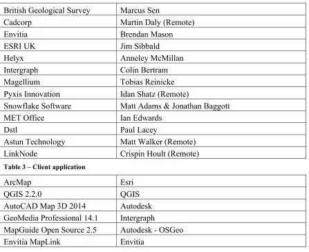
Table 1 – Participating Organizations and Individuals
British Geological Survey Marcus Sen
Cadcorp Martin Daly (Remote)
Envitia Brendan Mason
ESRI UK Jim Sibbald
Helyx Anneley McMillan
Intergraph Colin Bertram
Magellium Tobias Reinicke
Pyxis Innovation Idan Shatz (Remote)
Snowflake Software Matt Adams & Jonathan Baggott
MET Office Ian Edwards
Dstl Paul Lacey
Astun Technology Matt Walker (Remote)
LinkNode Crispin Hoult (Remote)
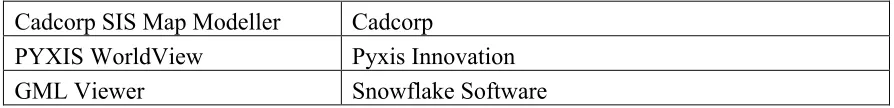
Table 3 – Client application
ArcMap Esri
QGIS 2.2.0 QGIS
AutoCAD Map 3D 2014 Autodesk GeoMedia Professional 14.1 Intergraph
MapGuide Open Source 2.5 Autodesk - OSGeo
Cadcorp SIS Map Modeller Cadcorp
PYXIS WorldView Pyxis Innovation
GML Viewer Snowflake Software
Table 4 – Services
GeoServer running on Tomcat with PostreSQL/PostGIS, deployed using Amazon Web Services
OS UK
GeoServer BGS
4.2 Plugfest Process, Activities, Procedures, and Artefacts
The OGC Plugfest was conducted on March 3, 2014 at the Ordnance Survey. Prior to the Plugfest, a Pre-Sprint 2 conference was organized for all participants for any last minute questions, observations and recommendations.
The published agenda for the day: 08:30 – 09:00 Arrival - coffee
09:00 - 09:15 Introduction – Peter Cotroneo and Bart de Lathouwer 09:15 - 11:00 GML (Including GML questionnaire)
11:00 - 12:00 WMS
The timing of the agenda was initially followed. However, GML section took more time than planned as we took more time to go over the GML questionnaire. Timing was regained as we reduced the time allotted for the WMS sprint. WMS was very successful in Sprint 1, so we decided to rerun the scenario very quickly.
The meeting room had a podium with a large projected screen – the participants sat at individual marked tables that faced the screen.
In Sprint 1 the OS introduced the various OS products and that helped participants understand the scenarios and context and was appreciated by all, especially organisations dialling in from outside the UK who were not familiar with the available OS products. This was not repeated for Sprint 2.
A GoToMeeting session was available for remote participants and included 2 wide-angle Webcams. This was a request from Sprint 1 participants to feel more included in the event.
A WIFI was available to the participants to access the OS services that ran in a cloud environment outside of the operational environment of the OS – this also allowed for the remote participants to access the services without having to be in the OS building and having the same interaction with the OS services. No WIFI or Internet connection issues were encountered during the Plugfest and WIFI performance was sufficient (no
performance measuring was done). 4.2.1 Scenarios
4.2.1.1 Scenario 1
In Scenario 1, participants from UK GI organisations tested their GML product(s) or data in a variety of commercial and open source GIS software. Ordnance Survey tested three of its products (GML 3.2 format): OS VectorMap District (VMD), OS Terrain 5, OS Terrain 50 and OS MasterMap Sites Layer. The goal of this use scenario was to understand which software supports which elements of GML.
OS VectorMap District (VMD) GML Application Schema passed the GML tests against the OGC Compliance Program's TEAM Engine2. The OGC Compliance Program (or
OGC Compliance & Interoperability Testing & Evaluation (CITE) program) is an on-going program that develops tests for OGC standards and makes those tests available for online testing of correct implementation of OGC standards. This web site is a resource for developers that are working with their software to make it OGC compliant, as well as for developers improving the testing scripts and software. It provides a summary of available tests, information about building the source code, reference implementation, etc. (see http://cite.opengeospatial.org).
4.2.1.1.1 Test steps
Connect to Ordnance Survey Network
What versions of GML does your application (officially) support (reading / writing)
Read OS VectorMap District into your client software (no query). SU28.gml ONLY.
Read OS VectorMap District into your client software (with query SU28, Surface_WaterLine 3062, Building 3433 (gml:id='os.vmd.su.215858' )).
Read OS VectorMap District into your client software (with query Query Building gmlid: 215858, verify featurecode is 25014 ).
Read OS VectorMap District into your client software (with query 145742 ).
Read OS Terrain 5 (query SU28NW.gml). Render as shaded model and contours in 3D environment (zoom in/out, Pan/…)
Does the application resolve the ASC from the GML automatically? (Applies only to OS Terrain Grid products)
If multiple Geometry types are available, how are they reported in the client application
Can you overlay the terrain model with OS VectorMap District
Optional: Style shaded model (Hill shading)
Can SLD be provided as part of the GetMap request?
Read OS Terrain 5 (with query). Render as shaded model and contours in 3D environment (zoom in/out, Pan/…)
Read OS Terrain 5 (with query). Render as shaded model and contours in 3D environment (zoom in/out, Pan/…)
see Su28nw and SD71NE
Read OS Terrain 50 (query SU28NW.gml). Render as shaded model and contours in 3D environment (zoom in/out, Pan/…)
Can you overlay the terrain model with other vector and coverages?
Read OS Terrain 5 (With query). Render as shaded model and contours in 3D environment (zoom in/out, Pan/…)
Verify: Feature Counts: Functional sites:508, access points: 1251, routing points 965.
(of the 508, 20 are multipolygon, 488 are polygons)
Displaying all layers from osmmsites_ed_england.gml.
For each of the above steps, the participants were requested to indicate success or failure (elaborate on failure and indicate graceful exit), indication of response time and
observations.
Because of the lengthy GML questionnaire, not all OS GML files where tested in the script (see strike through items in list above). All issues raised during Sprint 1 were rerun and verified.
4.2.1.1.2 Outcomes
Illustration 1, Terrain 5 using Intergraph Geomedia .
Illustration 2, Slope comparison using ArcMap (Esri) .
Illustration 3, GML rendering using Pyxis Worldview .
Observations (Sprint 1)
The following observations were gathered from : 1) comments in the Excel sheets containing the test steps, 2) comments in the GoToMeeting chat window and via email.
No distinction in Geometry Type
No distinction in geometry type for multi‐polygons within the FunctionalSite polygons layer, but is recognized as a multipart when queried.
Multiple access type and nature of access values for a given feature are comma separated, would prefer distinct XML features.
#### listed functionalSite layer as UNKNOWN geometry type but then loaded it as POLYGON.
No distinction in layer but is recognised as multipart as required. Site for Roads is shown as Polygon Z but Utilities is just Polygon
Source Data Issues
distinctiveName1, distinctiveName2, etc. doesn’t always map well to features e.g. a station where distinctiveName1 is “Station Road”
There are just under 10% of features in the functional site layer which have a null value for distinctivename1:
select count(*) from osmm_sites.functionalsite where distinctivename1 is null; count | 2466
OSTerrainContourProducts.xsd issue
OSTerrainContourProducts.xsd was in error. Excerpt from the original xsd:
<complexType name="DataSetType"> <complexContent>
<extension base="gml:AbstractFeatureType"> <sequence>
<element name="metadata"/> <element name="nominalScale"/>
<element name="elevationReference"/> <element name="equidistance"/>
<sequence minOccurs="0" maxOccurs="unbounded"> <element name="member"> </complexContent> </complexType>
Suggested fix:
<complexType name="DataSetType"> <complexContent>
<extension base="gml:AbstractFeatureType"> <sequence>
<element name="metadata"/> <element name="nominalScale"/>
<element name="elevationReference"/> <element name="equidistance"/>
Note the added complexContent element so that the member element explicitly extends gml:AbstractFeatureMemberType. This is required by GML 3.2 for a feature collection (9.9.1 of OGC's 07-036 / ISO 19136).
Manually changing the .xsd and having the .gml file point to the corrected .xsd solved the problem. The .xsd remained unchanged for Sprint 2. OS UK will correct the .xsd as a bug fix to the OS Terrain Contour Products.
4.2.1.2 Scenario 2
In Scenario 2, participants tested their implementations of the OGC WMS standard in a variety of commercial and open source GIS software. (Services had to be
WMS-compliant. See http://www.opengeospatial.org/compliance). Ordnance Survey tested OS OnDemand, which is a national WMS for Great Britain that delivers raster and rasterised vector data to its customers.
The following was tested for both WMS 1.1.1 and 1.3.0:
• GetMap, at all zoom levels and for each layer (including transparency).
• GetFeatureInfo, at all zoom levels and for specific layers (including transparency)
• GetCapabilities
• Coordinate systems that are used in the UK (e.g., ETRS89, WGS84, British National Grid, Irish Transverse Mercator, Irish Grid, etc.)
• Test user-friendliness of server throwing exceptions
• Bbox
4.2.1.2.1 Test steps
Connect to Ordnance Survey Network
What versions of WMS does the application (officially) support
http://betaosondemand.ordnancesurveyite.co.uk/ondemand/wms?REQUEST=GetCapabilities
Retrieve service capabilities using browser from endpoint (getCapabilities) (provide username & password)
Retrieve service capabilities using client from endpoint (getCapabilities) (provide username & password)
Retrieve service capabilities using client from endpoint without KVP's
Retrieve service capabilities using client from endpoint with WMS version mismatch (request version 1.2)
Retrieve service capabilities using client from endpoint for non‐existing end‐point
Retrieve service capabilities using client from endpoint (service returns invalid XML)
Retrieve service capabilities using client from endpoint (service returns valid XML, but containing invalid capabilities)
Verify 38 layers
Retrieve map in area <> and make screenshot
Retrieve map in area <> (using different CRS) ‐ is the map reprojected?
Retrieve all layers in area <> and make screenshot
Retrieve all layer for entire UK and make screenshot
Retrieve multiple layers ‐ is transparency correctly visualized
Click on a feature on the map and retrieve feature info using GetFeatureInfo.
Make a screenshot how the Feature Information is displayed
Retrieve service capabilities using application from protected endpoint (Is user authentication supported (OpenId, SAML2, Oauth)
Service Endpoint #2: http://ogc.bgs.ac.uk/cgi‐bin/BGS_Bedrock_and_Superficial_Geology/wms
Verify x layers
Retrieve map in area <> and make screenshot
Retrieve map in area <> (using different CRS) ‐ is the map reprojected?
Retrieve all layers in area <> and make screenshot
Retrieve all layer for entire UK and make screenshot
Retrieve only a number of selected layers ‐ can layers be individually selected and retrieved (unselected layers are not retrieved)
Retrieve multiple layers ‐ is transparency correctly visualized
Click on a feature on the map and retrieve feature info using GetFeatureInfo.
Make a screenshot how the Feature Information is displayed
Illustration 4, BGS Bedrock using Envitia MapLink
4.2.1.2.2 Outcomes
Version issues (Sprint 1 only)
"Expected: Open up Chrome and provide the following URL:
http://betaosondemand.ordnancesurveyite.co.uk/ondemand/wms?REQUEST=GetCap abilities&version=1.1.1. Get back WMT_MS_Capabilities version=""1.1.1"".
http://betaosondemand.ordnancesurveyite.co.uk/ondemand/wms?REQUEST=GetCap abilities&version=1.3.0. Get back WMS_Capabilities version=""1.3.0"".
VERSION=1.2.0 => GetCaps for 1.1.1 returned, VERSION=1.10.0 => GetCaps for 1.3.0 returned
Returns 1.3.0. If less than 1.1.1 (e.g. 1.1.0) returns 1.1.1 Works without KVP and gives Version 1.3.0
Actual: Seems to access 1.1.0 - may be appending this at the end as requesting this in Firefox without KVP gives back 1.3.0."
"Findings: Any number <1.2 goes to 1.1.0, and number above 1.3 goes to 1.3. When requests were made for retrieving capabilities for differing versions e.g. 1.1.0, the service returned a capabilities document at version 1.1.1. When requesting capabilities for an invalid version the service returned a capabilities document at 1.3.0.
Some services will return a ‘GetCapabilities’ response when the client omits to specify what request it is making.
Graceful exit
No un-graceful exists from applications were reported during Sprint 2.
Transparency
Transparency was correctly supported (portions of the bottom layers where visible, when added top most layers with transparency) by all client applications.
Performance
Feature implementation
GetFeatureInfo not implemented by all applications. When it was implemented, it returned the correct attributes (using ‘Plugfest Bingo’)
Observations (Sprint 1 feedback)
Ideally WMS (and other OGC web services) would return appropriate HTTP status codes when an exception is returned. Currently a HTTP status code of 200 is returned when a service exception occurs. This approach does not work well with the wider web. We have had issues when caching tiled WMS data using HTTP caching
software such as #### as by default responses with a HTTP response code of 200 are assumed to be successful and are hence cached. We do not want service exceptions to be cached so have had to do additional work to look at the MIME type of the
response to know that they should not be cached.
There is an issue with some client software ignoring 'layer limit' and subsequently brings in all layers. This could be important in bandwidth limited areas. The software can publish services compliant to our profile (using an external capabilities file), but cannot ingest in a totally compliant manner because of this. It is interesting the technicality of 'compliant' as far as publishing versus ingesting. Also, the potential to be compliant (based on changing xml files) versus 1-click compliance.
Layer naming
Illustration 6, layer naming issue (Envitia MapLink)
The individual layers had a very narrow display scale band. The capabilities do not advertise the min and max scale denominations. Therefore the client application could not determine the appropriate scales to display the layers.
While it was possible to add all the layers in a single request, there were conflicts in display in the scales. For instance, depending on the layer order, some of the products conflicted at particular scales. This was especially true for the 1:10K scale products. Only IMA25 had GetFeatureInfo available. It should be noted that the capabilities document had attribute entries of queryable=”false”. This is not compliant. However, it was accepted by the application.
Illustration 7, BGS Hydrogeology (Envitia MapLink)
Illustration 9, London Topo (Snowflake)
4.2.1.3 Scenario 3
In Scenario 3, participants tested their implementations of the OGC WMTS standard in a variety of commercial and open source GIS software. (Services had to be WMTS-compliant.) The goal of this use scenario was to understand the success rate of interoperability across the various GIS platforms.
4.2.1.3.1 Test steps
WMTS was run in Sprint 2 only – no WMTS was tested in Sprint 1. A very limited test plan was established for WMTS
Connect to Ordnance Survey Network
Service Endpoint #1:
http://ondemandapi.ordnancesurveyite.co.uk/osmapapi/wmtsgc/P7UGF35T/GetCapabilities?SE RVICE=WMTS&VERSION=1.0.0&REQUEST=GetCapabilities&URL=http://www.ogcplugfest.com
Does your application (officially) support version 1.0
Indicate support for KVP, REST, SOAP
OS OnDemand WMTS uses an API Key/Referrer model of authentication ‐ as many GIS clients assume a username/password model there may need to be some investigation of connection functionality.
Retrieve Tiles from osgb, Southampton
Zoom into Southampton
Is transparency supported? (if Tile has tranparency / alpha channel)
Retrieve Tiles from OS OpenData, Style: default TileMatrixSet "OS OpenData", Identifiers 00, 01,…,10, Tile x,y.
What image encoding is supported by the client?
Click on a feature on the map and retrieve feature info using GetFeatureInfo (if supported by the underlying WMS).
Make a screenshot how the Feature Information is displayed
Retrieve Legend image for the map
Service Endpoint #2 (External):
http://datapoint.metoffice.gov.uk/public/data/inspire/view/wmts?REQUEST=GetCapabilities&k ey=APIKEY
Access GetCapabilities
Connect and display available layers in Geospatial Portal
Service End‐Point 3 (External):
http://demo‐apollo.geospatial.intergraph.com/erdas‐iws/ogc/wmts
Display "bluemarble" layer
Service End‐Point 4 (External):
http://sampleserver6.arcgisonline.com/arcgis/rest/services/WorldTimeZones/MapServer/WMT S/1.0.0/WMTSCapabilities.xml
Display layer "WorldTimeZones".
4.2.1.3.2 Outcomes
WMTS service. Some applications were not able to handle referrer URLs at all, resulting
4.2.1.4 Scenario 4
4.2.1.4.1 Test steps
In Sprint 2, this test plan was not executed, as Sprint 1 indicated that a Cascading WMS behaves absolutely the same a non-cascading WMS. From a client application point of view, there is no distinction between a cascading WMS and non-cascading WMS. 4.2.1.4.2 Outcomes
The outcomes of the test plan steps are identical to WMS. 4.2.1.5 Scenario 5
In Scenario 5, participants will test their implementations of the OGC WFS standard in a variety of commercial and open source GIS software. (Services must be
WFS-compliant.) The goal of this use case is to understand the success rate of interoperability across the various GIS platforms.
4.2.1.5.1 Outcomes
Connect to Ordnance Survey Network
What versions of WFS does the application (officially) support
Supported Encodings by the client? (KVP, XML, SOAP). Can the user select a preference?
Retrieve service capabilities using browser from endpoint (GetCapabilities)
Retrieve service capabilities using client from endpoint (GetCapabilities)
Retrieve service capabilities using client from endpoint without 'GetCapabilities'
Service Endpoint #1: http://ogc.bgs.ac.uk/digmap625k_gsml32_gs/wfs
Retrieve layer x in area y and make screenshot
Can the user see the Feature Description (from GetFeatureType)
Retrieve all layers in area y and make screenshot
Retrieve all layer for entire UK and make screenshot
Retrieve layers x in coordinate system x and make screenshot
Does the client support Transactional WFS? (Insert, Update, Delete) ‐ Is Locking supported? (at what level?)
Retrieve service capabilities using browser from protected endpoint
Service Endpoint #2: http://www.snowflake‐
hydroview.com/proxy/activityregulation/2c7dc3634fcd6bfa6d93915dfd6a2096/?service=wfs&version=2.0 &request=GetCapabilities
Layer count
Retrieve service capabilities using browser from endpoint (GetCapabilities)
Retrieve service capabilities using client from endpoint (GetCapabilities)
Retrieve service capabilities using client from endpoint without 'GetCapabilities'
Count x layers
Retrieve layer x in area y and make screenshot
Can the user see the Feature Description (from GetFeatureType)
Retrieve all layers in area y and make screenshot
Retrieve layers x in coordinate system x and make screenshot
Service Endpoint #3:
http://sedsh13.sedsh.gov.uk/ArcGIS/services/HS/Historic_Scotland/MapServer/WFSServer?service=WFS& request=GetCapabilities&version=2.0
Layer count
Retrieve service capabilities using browser from endpoint (GetCapabilities)
Retrieve service capabilities using client from endpoint (GetCapabilities)
Retrieve service capabilities using client from endpoint without 'GetCapabilities'
Count x layers
Retrieve layer x in area y and make screenshot
Can the user see the Feature Description (from GetFeatureType)
Retrieve all layers in area y and make screenshot
Retrieve all layer for entire UK and make screenshot
Retrieve layers x in coordinate system x and make screenshot
Service Endpoint #4:
http://aws2.caris.com/sfs/services/ows/download/feature/UKHO_TS_DS?request=GetCapabilities&servic e=WFS
Layer count
Retrieve service capabilities using client from endpoint (GetCapabilities)
Retrieve service capabilities using client from endpoint without 'GetCapabilities'
Count x layers
Retrieve layer x in area y and make screenshot
Can the user see the Feature Description (from GetFeatureType)
Retrieve all layers in area y and make screenshot
Retrieve all layer for entire UK and make screenshot
Retrieve layers x in coordinate system x and make screenshot
4.2.1.5.2 Outcomes
The BGS service was difficult to test because of reliability issues (502 error and the service was overloaded after a full dataset retrieval (with a large BBOX or missing BBOX (albeit BBOX is mandatory))); furthermore the BGS was a WFS 2.0 service. Applications that did manage to get past the initial handshaking of GetCapabilities (V1.0.0 client (only Simple Feature Capable) to V2 WFS (with Complex Feature), client support for WFS 2.0.0 is behind) were unable to get access to layers or to display features.
The server reported failing to map ComplexFeatureType to SimpleFeatureType when a WFS v1.0.0 request was made to get a complex feature. This is because complex features cannot be encoded in the GML2 format, which is the default for WFS v1.0.0 responses. The GeoServer software does allow retrieval of the features if GML3 is specified as the outputFormat which is a vendor specific additional format listed in the capabilities. Listing a (complex) feature in the v1.0.0 GetCapabilities response which cannot actually be returned in the default GML2 format is probably not standards compliant but it does allow a workaround of including outputFormat=GML3 in the base service URL which can be used with some v1.0.0 clients to retrieve the features.
(Whether this is helpful or confusing is debatable.) The QGIS WFS 2.0 Plugins was able to display the polygons only.
The Snowflake WFS also reported schema validation errors (e.g. ’non‐whitespace characters are not allowed in schema declarations other than appinfo and
Applications reported that the BBOX parameters must be included to avoid reading all features from the layer (see also service reliability at the start of the paragraph).
In order to continue testing, we took 2 WFS services from data.gov.uk – one serving Historic Scotland, the other serving UKHO information. Plugfest bingo on both services reported consistent numbers.
Illustration 10, Historical Scotland (MapGuide)
We also tried WFS reference site implementations
(http://cite.opengeospatial.org/reference), but some of the links were broken. This was reported to the OGC CITE team.
When complex schemas (like GeoSciML) were served to a WFS client that was not designed to accept a complex schema, no clients crashed but showed the feature attributes without interpreting them.
5 Summary of Recommendations and conclusion
GML
Not all organizations participated in this scenario. Reading GML files is not 100% widespread
The organizations that participated in this scenario did not report any severe
difficulties or problems. Since the fact that the GML specification is very broad and is perceived as a complex standard, more issues were expected. (The Geometry Type being wrongly represented in the UI did not cause any computational and
misrepresentation in the map)
Recommendation: The OS GML files (Simple Features level 0) used during Sprint 1 and Sprint 2 can be used in an operational environment.
Ordnance Survey prepared a questionnaire for Sprint 2 to investigate support for GML beyond SF-0. The questionnaire is at Annex A. It was not practical to complete this questionnaire during the Sprint; Ordnance Survey is interested in taking this discussion forward, and would welcome any responses.
WMS
All organizations participated in this scenario. All applications were able to execute the scenario without difficulties and the queries resulted in the expected images from the services. Some minor non-blocking observations with WMS version number, when the number provide is not the returned version (will take this up with the WMS SWG).
Not all client applications implement GetFeatureInfo. If this feature would be more widely implemented, it would benefit overall interoperability and increase a uniform user experience.
Recommendation: raise awareness of ‘GetFeatureInfo’ with the organisations that build client software
Performance of OS services was immediate or sub-second for the requested queries in the scenario and is according to market expectations.
The various client software dealt with unexpected behaviour from the server by showing the error that was returned from the server (no software crashed or showed an internal message or stack trace). The messages from the server are however not very end user-friendly (subject to further investigation in Sprint 2)
Sprint 1 demonstrated good results and it was deemed unnecessary to dive any deeper in Sprint 2.
WMTS
Service End-Point protection using referrer URL’s did not work (referrer URL’s are not part of the WMTS specification).
API key protected site worked, but acquiring an API key was problematic, due to a BGS back-office problem.
Recommendation: Adding security to in the service URL (either using the referrer URL or using API key) adds to the risk of service unavailability. Alternatives should be investigated.
All WMTS clients had difficulties showing tiles - it was unclear where in the service capabilities document the issues were. Further investigation (on the service side) is needed to determine why titles did not show up.
Recommendation: WMTS instances as serviced during the Plugfest were immature and not ready for operational deployment.
WMTS Client implementation did not give a clear explanation why tiles could not be visualized.
Recommendation: WMTS clients need to provide better user feedback as to why tiles cannot be visualized at specified zoom/scales levels
WMS-Cascading
Comments identical to WMS.
Observation: Cascading had no effect on the WMS behaviour from a client software perspective.
Recommendation: Using a Cascading WMS in an operational environment is likely not to cause any issues and give the OS the opportunity to add, update and remove layers at runtime, depending on customer requirements and needs.
WFS
Scotland and UKHO) worked fine. There was limited client support for WFS v2.0.0. Generic WFS clients have a limited ability to display properties of complex features. Conclusions
The Plugfest demonstrated that GML and WMS (including WMS in a cascading configuration) are very mature and can be deployed in an operational environment. WMTS service implementations needs further attention and should be better checked before using them in a Plugfest. It was hard to test he client against the service and give an indication of maturity.
Service protection through referrer URL’s (most client did not support this) and API keys (insatiability of back-office issuing the keys) adds to the unavailability of WFS services. Alternative techniques must be investigated or better client support for referrer URL must be encouraged.
Future Plugfests should focus on WFS and especially WMTS (which is getting a lot of traction and is a viable alternative to WMS when fast response times are required) and service security implementations.
Annex A
GML
6 Sprint 1 and Sprint 2 GML
During Sprint 1, we demonstrated that the software could read the GML, which adhered to GML 3.2 Simple Features Profile level 0. Even within that specification, there are a number of design choices, the idea here is to probe support for the options, and look at the different user experience that data design choices provide.
For the Ordnance Survey, this will be a valuable steer to our future data design. We hope to have the opportunity to introduce the output into the INSPIRE Maintenance &
Implementation Framework, as a steer for simplifying some of their schemas and specifications.
The questions below in the text were asked during Sprint 2 and the answered were collated by the OS.
6.1 Simple Features Profile in general (level 0) 6.1.1 Geometry / spatial property types
GML Simple Features, following OGC Simple Feature Access, constrains the geometry types to Point, Curve (LineString), Surface (Polygon), ‘Geometry’, MultiPoint,
MultiCurve, MultiSurface, MultiGeometry.
During sprint 1, we noticed that one software raised a warning when presented with a MultiGeometry, but then successfully displayed the LineStrings that delimited the surface.
Question : which geometry types are supported? What is the user experience with each geometry?
See Table 6 in GML SF
GML property type
Values OS Sample data
PointPropertyType Point OS Terrain Spot heights;
VMD SpotHeight, NamedPlace CurvePropertyType LineString Linear
interpolation
VMD
Line
Arc Non-linear
interpolation
Polygon Co-planar vertices -
Surface with
LinearRing FunctionalSite etc Ring with single
Surface -
MultiPoint -
MultiCurve -
MultiSurface -
Question: what does the software do with a feature that has a GeometryPropertyType, in particular if different instances of that feature have geometries of different types e.g. Point, LineString, Surface?
Question: in a 2D coordinate space, is there any difference in user experience, or software performance, between a Polygon and a Surface with a single PolygonPatch?
Note: GML SF allows non-linear interpolation, explicitly gml:Arc, gml:Circle, gml:CircleByCenterPoint
Question: Are the geometry types restricted to those in OGC Simple Feature Access? Note: Ordnance Survey does not have any known requirement for non-linear
interpolation, so is unable to make test data available to exercise this point. 6.1.2 Coordinate space
OGC simple geometry coordinates can be in 2D or 3D space.
Note: Although otherwise the same, ISO 19125 Simple features are constrained to 2-dimensional coordinate space.
Question: given data with coordinates in a 3D space, what ‘3D’ functionality is available to the user?
Test data: OS MasterMap Networks – Water Layer 6.1.3 Spatial reference system
GML SF allows the srsName to be specified once, on the gml:BoundedBy property of the feature collection, on the gml:boundedBy of each feature instance, or on each geometry object. It recommends that the srsName be specified at the highest possible level. Question: how does the software behave with this SF best practice, the srsName appearing only on the bounding box of the feature collection? Is it better to explicitly state it on each geometry?
Question: how does the software behave if it encounters geometry objects in different coordinate systems? Does it make a difference if different feature types use different systems, but they are consistent within the type? (e.g. 2D contours and 3D rivers?) 6.1.3.1 Referencing the srsName
Does the software accept references in URN form, e.g. urn:ogc:def:crs:EPSG::27700 ? (as given in examples in the GML 3.2.1 spec)
Does the software accept references in URL form, e.g.
http://www.opengis.net/def/crs/EPSG/0/27700 ? ( as given in examples in the GML 3.3 spec)
Does the software accept references in short ‘well known’ forms e.g. ‘EPSG::27700’, ‘BNG’, ‘ETRS89-LAEA’ (as specified in INSPIRE CRS Guidance)?
6.1.3.2 Recognising spatial reference systems
In Sprint 1, we demonstrated that the software recognises
http://www.opengis.net/def/crs/EPSG/0/27700 as British National Grid.
Question: Which of the following other spatial reference systems does the software recognise:
UK Location CRS guidance:
http://www.opengis.net/def/crs/EPSG/0/4258 2D ETRS 89
http://www.opengis.net/def/crs/EPSG/0/4326 2d WGS84
http://www.opengis.net/def/crs/EPSG/0/27700 OSGB 1936 / British National Grid
http://www.opengis.net/def/crs/EPSG/0/29903 TM 75 / Irish Grid
http://www.opengis.net/def/crs/EPSG/0/2157 ETRS89 / Irish Transverse Mercator
http://www.opengis.net/def/crs/EPSG/0/3035 ETRS89 Lambert Azimuthal Equal Area (ETRS89-LAEA) projection
urn:ogc:def:crs:EPSG::7405 – compound (3D) reference system of British National Grid and Newlyn Datum (Sample data: Water network)
Question: does it help to include either or both of srsDimension and count, e.g. in each posList?
6.1.4 Schema design
A GML application schema can declare the SF level to which it complies. It can also import other GML application schemas. There is nothing explicit about whether the imported schemas need to be ‘simple’.
Question: if a GML application schema declares itself to be, say, SF-0, and then imports a schema that doesn’t specify conformance to any simple features level, what does the software do?
Personal note: if/when I create a schema like this, I would intend it to mean that all my data instances will be simple, even if the generic schema doesn’t require them to be.
6.1.5 Measures
Simple Features allows properties to use gml:MeasureType, which is an extension of xs:double. It does not discuss subtypes of MeasureType, such as gml:LengthType Question: assuming properties can have a value that is a measure, what is the user experience of the ‘uom’ attribute?
The GML 3.2.1 examples include
<height uom=”http://www.equestrian.org/units/hands">14</height>
Question: does it matter what form the uom attribute takes – ‘well known’ symbol or URI?
Question: how would an instance with uom=’unknown’ be handled (this is explicitly allowed in SF)
Sample data: OS Terrain SpotHeight.propertyValue is a measure (uom=’m’); VMD SpotHeight.height is a simple number. No OS sample at present with URLs
Question: is it acceptable to use a more specalised type in the application schema, such as gml:LengthType? (The instance data would look the same)
6.1.6 Code lists and dictionaries
GML SF allows elements with string content from a code list, where an instance looks like:
<os:functionTheme
codeSpace="http://www.ordnancesurvey.co.uk/xml/codelists/sitethemes.xml ">Education</os:functionTheme
GML SF also allows ‘elements that reference other resources’. GML 3.3 deprecates the code list and states that all references to external dictionaries shall use the reference pattern.
<water:reasonForChange
xlink:href="http://www.ordnancesurvey.co.uk/xml/codelists/reasonforchan ge.xml#new" xlink:title="new"/>
Sample data: Sites uses code lists; Water uses a mix (external dictionary, except where inherited from INSPIRE Hydrography, which uses code list).
Question: what difference does it make to the user experience? What use can a user make of the codeSpace and/or xlink:href URLs? The xlink:title?
6.2 Simple Features Profile compliance level 1
In general, software did not claim to support SF-1, but some of the software allowed the user to access data within user defined types.
Question: which aspects of SF-1 would be difficult to support? 6.2.1 User defined property types
6.2.2 Use of nillable and xsi:nil
Test data: although it doesn’t explicitly use xs:nillable in the schema (except if inherited from INSPIRE?), the water network does sometimes have data instances that use xsi:nil, and nilReason.
6.2.3 Maximum multiplicity > 1
Question: what is the user experience if a data instance contains a repeated XML element, representing more than one instance of the property?
6.3 Aspects of GML 3.3
GML3.3 introduces a number of optional additional clauses that can be used in conjunction with GML3.2.
Overall Question: which of the GML 3.3 clauses are already supported in the software? Which would be difficult to support?
6.3.1 LanguageStringType
This is exactly the same as LanguageStringType described in GML SF (except that the GML SF definition has the xml:lang explicitly optional). GML SF requires it to be added to the application schema (which therefore has to import the W3C xml.xsd).
Question: does the software behave the same if the application schema imports
LanguageStringType from GML 3.3, which results in any localisable strings being in a different namespace?
6.3.2 Dictionaries as gml:ReferenceType See 6.1.6 above
6.3.3 Reference data
During Sprint 1, the following simple Ordnance Survey products were tested, along with OS Terrain grid (which is not simple, as it imports a grid file for its geometry):
6.3.3.1 OS VectorMap District
VMD claims to be SF-0, but actually mistakenly defines its Feature Collection to substitute for gml:AbstractFeature (rather than gml:AbstractGML). This would not be apparent when looking at the data. That is, we could change the VMD schema to be properly conformant, and the data would still be valid.
Also, several feature types have properties that take a user defined type:
• Roundabout.classification: RoadClassificationValueType
• AdministrativeBoundary.classification:AdministrativeBoundaryClassificationValueType • RailwayTrack.classification:RailwayTrackClassificationValueType
• RailwayStation.classification:RailwayStationClassificationValueType • PublicAmenity.classification: PublicAmenity ClassificationValueType
In each case, the user defined type is a restriction of string to an enumerated set of values; so the instance data will look simple.
Instance geometries are Point, LineString, Surface with a single PolygonPatch which has an exterior and 0..* interiors, each of which is a LinearRing.
6.3.3.2 OS Terrain 5, OS Terrain 50 vector
Declares SF-0, but as with VMD defines its feature collection (DataSet) to substitute for gml:AbstractFeature. The DataSet contains several elements that are undefined
(metadata, nominalScale, elevationReference, equidistance)
The string values that are controlled enumerations do so by means of a globally defined simple type (e.g. WaterLevelValueType).
The propertyValue properties on each feature type are of gml:LengthType (a subtype of Measure) – this is not explicitly allowed in GML SF
None of these issues impact the GML instance data; that is the schema could be changed to conform more accurately to SF without needing to change the data. It would then be further from the INSPIRE schema on which it was based.
Instance geometries are Point and LineString 6.3.3.3 OS MasterMap Sites Layer
Claims to be SF-0, but again mistakenly defines its Feature Collection to substitute for gml:AbstractFeature.
Includes several user defined types:
• ReasonForChangeValueType
• AccessTypeValueType
• AccessMechanismValueType
• AccessDirectionValueType • AccessUseRestrictionValueType • NaturOfAccessValueType
The schema also includes ‘PropertyType’ for each feature type, allowing ‘by reference’ containment (gml:AssociationAttributeGroup, gml:OwnershipAttributeGroup). This isn’t explicitly mentioned in SF, either to allow or deny. Also it is not used for the
relationships between the features – explicit attributes carry the TOID of the target as a string.
Annex B
UML
7 OS Terrain: Coverages
class Cov erages
«featureType»
Elev ationGridCov erage
+ interpolationType :CV_InterpolationMethod = bilinear + propertyType :ElevationPropertyTypeValue = height + surfaceType :SurfaceTypeValue = DTM
«featureType» gml:RectifiedGridCoverage
+ rectifiedGridDomain :gml:RectifiedGrid + rangeSet :gml:File
«enumeration»
CV_InterpolationMethod
bilinear
«enumeration»
Elev ationPropertyTypeValue
height depth
«enumerati...
SurfaceTypeValue
DTM DSM Exactly 1 in a Grid
7.1 OS Terrain: Vector Elements
class Vector Elements
«featureType»
ContourLine
+ geometry :GM_LineString + propertyValue :Distance
+ contourLineType :ContourTypeValue
«enumeration»
+ geometry :GM_Point + propertyValue :Distance
+ spotHeightType :SpotHeightTypeValue = generic
«enumeration»
+ geometry :GM_LineString + propertyValue :Distance
+ waterLevelCategory :WaterLevelValue
«featureType»
OS Terrain::DataSet
+ metadata
+ nominalScale :Integer + elevationReference + equidistance :Distance [0..1]
7.2 OS MasterMap Site Layer class Product - Functional Sites
«featureType»
FunctionalSite
+ geometry :GM_Object + toid :CharacterString + version :Integer + versionDate :Date
+ reasonForChange :ReasonForChangeValue + functionStatus :FunctionStatusValue + functionTheme :FunctionThemeValue + function :FunctionValue + perimeter :Length + area :Real
+ distinctiveName1 :CharacterString [0..1] + distinctiveName2 :CharacterString [0..1] + distinctiveName3 :CharacterString [0..1] + distinctiveName4 :CharacterString [0..1] + primaryAddressBaseUPRN :Integer [0..1] + stakeholder1 :CharacterString [0..1] + stakeholder2 :CharacterString [0..1] + stakeholder1Role :StakeholderRoleValue [0..1] + stakeholder2Role :StakeholderRoleValue [0..1] + extentDefinition :ExtentDefinitionValue
«featureType»
AccessPoint
+ geometry :GM_Point + toid :CharacterString + version :Integer + versionDate :Date
+ reasonForChange :ReasonForChangeValue + refToFunctionalSite :CharacterString + accessType :AccessTypeValue
+ accessMechanism :AccessMechanismValue [0..1] + accessDirection :AccessDirectionValue [0..1] + accessUseRestriction :AccessUseRestrictionValue [0..1] + refToRoutingPoint :CharacterString [0..1] + refToITNRoadNode :CharacterString [0..1] + itnRoadNodeVersionDate :Date [0..1] + dateTimeQualifier :Real [0..1] + heightQualifier :Distance [0..1] + widthQualifier :Distance [0..1] + weightQualifier :Real [0..1] + lengthQualifier :Distance [0..1] + natureOfAccess :NatureOfAccessValue
«featureType»
RoutingPoint
+ geometry :GM_Point + toid :CharacterString + version :Integer + versionDate :Date
+ reasonForChange :ReasonForChangeValue + refToITNRoadLink :CharacterString + itnRoadLinkVersionDate :Date + startDistance :Length
«codeList»
+ Air Transport + Education + Medical Care + Rail Transport + Road Transport + Water Transport + Utility or Industrial
«codeList»
StakeholderRoleValue
+ Administered By + Owner Of + Principal User Of + Religious Interest In «codeList»
AccessTypeValue
+ Cycles + Horse Drawn Vehicles + Mopeds + Motorcycles + Motor Vehicles + Pedestrian
+ Ridden or Accompanied Horses + Undefined
«codeList»
AccessUseRestrictionValue
+ Disabled + Emergency Access + Guests + Official Business + Patrons + Residents + Through Traffic
«codeList»
AccessMechanismValue
+ Appointment + Official Pass + Pay and Display + Helicopter Station + Heliport
+ Non State Primary Education + Non State Secondary Education + Special Needs Education + Primary Education + Secondary Education + Further Education + Higher or University Education + Hospice
+ Hospital
+ Medical Care Accommodation + Railway Station + Vehicular Rail Terminal + Vehicular Ferry Terminal + Passenger Ferry Terminal
+ Port Consisting of Docks and Nautical Berthing + Bus Station
+ Coach Station + Road User Services + Chemical Works + Electricity Distribution + Electricity Production + Gas Distribution or Storage + Oil Distribution or Storage + Oil Refining + Manned Barrier + Monitored Rising Barrier + Monitored Rising Bollards + Moveable Barrier + Opening + Revolving Door + Rising Barrier + Rising Bollards + Shutter
+ Fully Defined + Partially Defined + Undefined
{No ITN Node within tolerance} +refToRoutingPoint
7.3 OS VectorMap District
class Administrativ e Boundaries
«codeList» BoundaryType
+ National
+ Parish Or Community + District Or London Borough + County Or Region Or Island VectorMapDistrictFeature
«featureType» Administrativ eBoundary
+ geometry :GM_LineString + classification :BoundaryType ::VectorMapDistrictFeature + featureCode :Integer
class Buildings & Structures
VectorMapDistrictFeature
«featureType»
HeritageSite
+ geometry :GM_Point + name :CharacterString
::VectorMapDistrictFeature
+ featureCode :Integer
VectorMapDistrictFeature
«featureType»
Glasshouse
+ geometry :GM_Polygon
::VectorMapDistrictFeature
+ featureCode :Integer
VectorMapDistrictFeature
«featureType»
ElectricityTransmissionLine
+ geometry :GM_LineString
::VectorMapDistrictFeature
+ featureCode :Integer
VectorMapDistrictFeature
«featureType»
Building
+ geometry :GM_Polygon
::VectorMapDistrictFeature
+ featureCode :Integer
VectorMapDistrictFeature
«featureType»
Ornament
+ geometry :GM_Polygon
::VectorMapDistrictFeature