Climate Change Adaptation Series: Document 8
VILLAGE VULNERABILITY ASSESSMENTS AND
CLIMATE CHANGE ADAPTATION PLANNING (V&A)
JAMBIANI AND PAJE, ZANZIBAR, TANZANIA
March 2012
Prepared for the Pwani Project
by
This report is part of the Pwani Project’s Coastal Community Adaptation Series, which includes the following documents:
1. Coastal and Marine Ecosystems in a Changing Climate: the Case of Tanzania. 2. Workshop Proceedings: Tanzania Coastal Climate Change National Adaptation
Planning Workshop
3. Village Vulnerability Assessments and Climate Change Adaptation Planning (V & A): Kitonga, Bagamoyo District
4. Village Vulnerability Assessments and Climate Change Adaptation Planning (V & A): Mlingotini, Bagamoyo District
5. Rapid Assessment of Shoreline Characteristics and Dynamics of the Lazy Lagoon at Mlingotini Village, Bagamoyo
6. Livelihoods, Climate and Non-Climate Threats and Adaptation: Pangani District Coastal Villages
7. Livelihoods, Climate and Non-Climate Threats and Adaptation: Bagamoyo District Coastal Villages
8. Village Vulnerability Assessments and Climate Change Adaptation Planning (V & A): Jambiani and Paje, Zanzibar
9. Village Vulnerability Assessments and Climate Change Adaptation Planning (V & A): Kitonga and Mlingotini Villages, Bagamoyo District (Summary Report) 10. Village Vulnerability Assessments and Climate Change Adaptation Planning (V &
A): Mwembeni, Pangani District
11. Village Vulnerability Assessments and Climate Change Adaptation Planning (V & A): Sange, Pangani District
This publication is available electronically on the Coastal Resources Center’s website at http://www.crc.uri.edu. For more information contact: Coastal Resources Center,
University of Rhode Island, Narragansett Bay Campus, South Ferry Road, Narragansett, Rhode Island 02882, USA. Tel: (401) 874-6224; Fax: (401) 874-6920.
Citation: Shaghude, Y.W and Jiddawi, N. S. (2012). Village Vulnerability
Assessments and Climate Change Adaptation Planning (V & A): Jambiani and Paje, Zanzibar, Tanzania. Coastal Resources Center, University of Rhode Island,
Narragansett, RI, 33 pp.
Disclaimer: This report is made possible by the generous support of the American people through the United States Agency for International Development (USAID). The contents are the responsibility of the Coastal Resources Center at the University of Rhode Island as part of the Tanzania Coastal Management Partnership/Pwani Project, Cooperative
Contents
1.0 INTRODUCTION ... 1
2.0 CLIMATE CHANGE PROJECTIONS AND TRENDS ... 3
3.0 VULNERABILITY ASSESSMENT METHODOLOGY ... 7
3.1 Sensitization Sessions ... 8
3.2 Stakeholder Analysis ... 8
4.0 VULNERABILITY ASSESSMENT, PAJE AND JAMBIANI VILLAGES ... 10
4.1 Introduction of the Concept of Climate Change ... 10
4.2 Information on Physical Impacts from Climate and Non-climate Stresses ... 10
4.3 Climate Impacts and Sensitivities Identified by the Communities ... 14
4.4 Adaptive Capacity of Paje and Jambiani Villages ... 18
5. ADAPTATION OPTIONS AND RECOMMENDATIONS... 20
5.1 Key Actions Suggested by the Communities... 20
5.2 Promotion of Good Shore Management Practices ... 20
6. CONCLUDING OBSERVATIONS ... 25
REFERENCES ... 26
Appendix 1: Questionnaire Results, Perception of Environmental Change ... 27
1.0 INTRODUCTION
There is now wide agreement by most scientists and climate change professionals that climate change and increased climate variability are already occurring and having serious consequences for many African countries, including Tanzania. The predictions from the experts on climate change are that the problems caused by climate changes will increase and make management of coastal ecosystems and improvements to community resilience even more difficult. The following threats are predicted to cause major problems for coastal resources and the well-being, safety, and food security of coastal communities:
1. More unpredictable precipitation (seasonality and intensity) 2. Increases in strong storms
3. Changes in wind speed and seasonality 4. Sea level rise
5. Increased sea surface and ambient air temperatures 6. Increased ocean acidification
These climate and chemical threats and the problems they create are on top of and in addition to existing local stresses. In most of coastal Tanzania, these include deforestation, over fishing, deterioration in water supply and quality, and development pressures.
Beginning in 2010, the Pwani Project in partnership with researchers from the Institute of Marine Science (IMS), University of Dar es Salaam, initiated an effort to help local leaders and government to assess climate change impacts and find ways to adapt to current and future climate change impacts in a strategic way using their own resources and knowledge. This is part of a larger coastal management effort in a partnership with the government of Tanzania and the United States Agency for International Development (USAID). This Project has a geographic focus on the island of Unguja in Zanzibar and the ecologically important northern coast of mainland Tanzania – Bagamoyo and Pangani Districts. The overall goal is to help sustain the flow of environmental goods and services; revise the trend of environmental destruction of critical coastal habitats; and improve the wellbeing of coastal residents in the Bagamoyo-Pangani and Menai Bay Seascapes.
As a small island, Zanzibar is more vulnerable and faces greater climate change risks— particularly those related to coastal and shoreline impacts—than does the mainland. This is illustrated in the 2010 document “Adaptation to Climate Change: Preparation of an Adaptation Programme of Action for The Revolutionary Government of Zanzibar” that was prepared by the Sustainable Management of Land and Environment (SMOLE) project. This document, endorsed by the Ministry of Water, Construction, Energy and Land, Zanzibar and the Ministry of Agriculture, Livestock and Environment, Zanzibar, highlights the need for climate change data; strengthened disaster management and reduction capabilities; ICM; and a focus on coastal and marine resources at risk, as well as other major economic sectors at risk—e.g., tourism, fisheries, seaweed farming, and agriculture.
addition, a technical committee comprised of Department Directors has been launched, and the formation of working groups on specific climate change issues has been approved. In January 2011, the RGOZ launched a comprehensive study on the economics of climate change on Zanzibar. The full draft, which is currently under review, provides a basis for the formulation of a Zanzibar Climate Change Strategy and a Zanzibar-specific NAPA. This vulnerability assessment document contributes to this larger effort.
The USAID/Pwani project in Paje and Jambiani is rooted on an earlier project of a regional programme for the sustainable management of the coastal zones of the countries of the Indian Ocean (ReCoMap), which was conducted at Jambiani and Paje villages, along the eastern coast of Unguja Island, Zanzibar. The ReCoMap project was a two year (2009-2010) European Union funded project whose main goal was to empower the coastal communities to plan for sustainable coastal livelihoods using GIS and modeling decision support tools. It collected scientific knowledge on the major causative factors of shoreline changes along the Jambiani/Paje coastal section for the purpose of developing future adaptation strategies.
At the completion of the ReCoMap project all the GIS data results and the modeling data results were synthesized but the project had ended before disseminating and sensitizing the important aspects of the results to local stakeholders. In view of this, the TCMP Pwani project followed-up was for the purpose of climate change vulnerability assessment and development of climate change adaptation strategies.
The specific objectives of the TCMP Pwani project for vulnerability assessments include the following:
1. To develop awareness and understanding of the concept of climate change.
2. To develop awareness and understanding on the natural factors that had been contributing to the observed shoreline changes along the coastal sections of Jambiani and Paje villages.
3. To develop awareness and understanding on the human factors that had been contributing to the observed shoreline changes.
2.0 CLIMATE CHANGE PROJECTIONS AND TRENDS
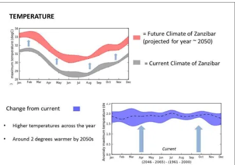
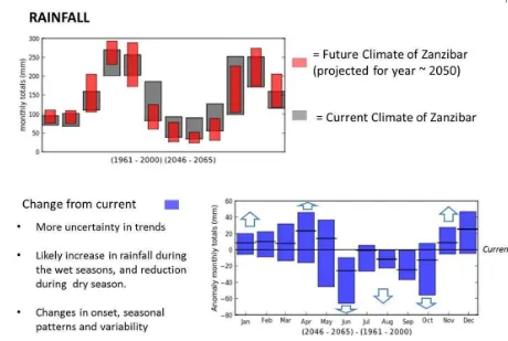
The overall observations for climate trends in Zanzibar indicates large inter-decadal variations in sea levels, with decreasing trends from the 1980s (Ragoonaden, 2006), and recent rising trends especially after 2004 (Watkis et al, 2012). Analyses of meteorological data reveal strong evidence of rising air temperature over the last 30 years with strong increases in average and maximum temperatures in December to May. There are also indications of rainfall variability, change of wind and wave climate regime and extreme weather events, with higher rainfall intensity events, increasing wind speeds and wave heights and increase of extreme weather events in recent years (Shaghude Dubi, 2008; Watkis et al, 2012). The sea will become more acidic from carbon sequestered in the sea which then forms carbonic acid, and areas with bimodal rainfall patterns) will experience increased rainfall. These are the trends suggested by existing models and research.
Sea level rise causes habitat inundation, shoreline erosion, and saline intrusion to groundwater and soil. Ocean acidification can weaken corals and other marine animals that have shells or skeletons made of calcium carbonate (such as shellfish and starfish). More intense rainfall over the rainy season can cause flooding and loss of crops. Higher sea temperature can result in coral bleaching and mortality, increase incidence of disease in marine animals, and alter the seasonality of biological events and abundance and distribution of fish.
From this starting point, village level V&As seek to overlay local knowledge on climate trends that are beginning to show themselves in the two villages and to plan accordingly. For example, local knowledge can help answer the basic question: “Has the frequency, magnitude, or timing of precipitation, flooding, or drought events changed in the last several decades?” By integrating best available scientific knowledge with local knowledge, communities and government can take responsible action even in situations where there is imperfect climate change information.
Global climate change is one of the greatest challenges that humans will face in this century (Mcleod et al., 2006). Although geological records show climatic changes throughout history, the present rate of global warming threatens the survival of entire ecosystems (Mcleod et al.,
2006). Small islands and low lying coastal areas are especially vulnerable to climate change. Zanzibar also has seen some changes in wind patterns. (See for example Figures 1 and 2).
According to Tilya (2012), climate of a location encompasses the statistics of weather taken over longer period of time, say 30 years, and this is affected by its latitude, terrain, and altitude, as well as nearby water bodies and their currents and climate change ooccurs when changes in climate elements mean or variance or both distribution are observed.
institutions. The vulnerability assessment presented in this report was carried out in a way that aims to correct this imbalance.
It is known that the abundant natural wealth and scenery of the coast of Jambiani and Paje villages have provided livelihoods for many years to coastal communities. The key livelihoods are fisheries, burying coconut husks and some agriculture. Seaweed farming and tourism started in the last 20 years. With most of the population living directly along the coast, greater pressure is placed on it from human uses. Global climate change will intensify that pressure. Also with rising sea levels, increased storms and higher temperatures predicted, the challenge will be to manage coastal activities in a sustainable way whilst ensuring the health of coastal ecosystems (Mazilli et al., 2010).
Some of these activities put pressure along the coast e.g. the cutting of sea grass in seaweed areas, mining of live corals, and dragging activity of collecting seaweed, contribute to various negative natural and socio-economic impacts along the coast. These include increased coastline erosion, declines in abundance of fish and the consequent impact on fisheries and livelihoods, changes in the composition of fish communities, loss of aesthetic value to reefs and shoreline that are important for tourism, and reduced forest cover (Mazilli et al., 2010).
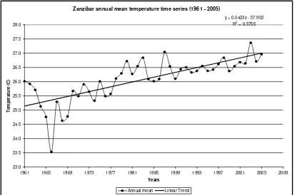
Figure 1. Rise in average temperature Zanzibar 1961-2005 (+1.9°C). Source: Tanzania Meteorological Agency
Looking forward, The UK DFID funded “Economics of Climate Change” project developed
Zanzibar annual mean temperature time series (1961 - 2005)
y = 0.0423x - 57.902
1961 1965 1969 1973 1977 1981 1985 1989 1993 1997 2001 2005 2009
3.0 VULNERABILITY ASSESSMENT METHODOLOGY
Vulnerability factors are the degree to which the particular area and people are impacted (sensitivity), the types and amount of assets at risk (exposure), and the ability to cope with actual or expected changes (adaptive capacity).
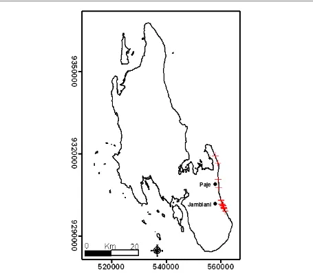
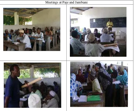
Paje and Jambiani are situated on the east coast of Unguja Island (Figure 4), The methodology used to achieve the aims of the assessment began through a series of sensitization meetings (Figure 5), followed by field practical demonstrations and sharing of experiences from amongst the local communities. Also a questionnaire based on what changes have been observed by the community to determine their understanding on climate change and what should be done was given to about 64 people and the results are presented in Appendix 1 (Figures 10 and Figure 11)
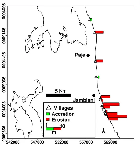
Figure 4. The Map of Unguja Island, Zanzibar showing the location of the Jambiani village. Note that the red plus symbols were the sites where magnitude and rates of erosion were estimated during the ReCoMap study.
3.1 Sensitization Sessions
At least two meetings in each village were used to gather information from villagers on vulnerability and adaptation options. The sensitization meetings were conducted in Jambiani and Paje between June and December 2011. The participants of both meetings included: village leaders, representatives from various local community groups, fisherfolks, school teachers, local non-governmental organizations, and representatives from different age groups.
Some definitions used during the sensitization meetings include the following: (Know climate change, 2012)
Vulnerability is a function of the character, magnitude, and rate of climate change and variation to which a system is exposed, its sensitivity, and its adaptive capacity. It is the degree to which a system is susceptible to, or unable to cope with, the adverse effects of climate change, including climate variability and extremes
Adaptive capacity: The capacity for natural or human systems to adjust in response to actual or expected climatic changes or their impacts, so as to reduce harm or exploit beneficial opportunities.
Coping Range: Coping range represents the magnitude or rate of disturbance various systems like communities, enterprises, or ecosystems can tolerate without significant adverse impacts or the crossing of critical thresholds.
3.2 Stakeholder Analysis
During these meetings each community was asked to mention the key stakeholders in their areas. Stakeholder analysis is a methodology used to facilitate institutional and policy reform processes by accounting for and often incorporating the needs of those who have a ‘stake’ or an interest in the reforms under consideration. With information on stakeholders, their interests, and their capacity to oppose reform, reform advocates can choose how to best accommodate them, thus assuring policies adopted are politically realistic and sustainable.
Four major attributes are important for stakeholder analysis: the stakeholders’ position on the reform issue, the level of influence (power) they hold, the level of interest they have in the specific reform, and the group/coalition to which they belong or can reasonably be associated with.
Table 1. Summary of stakeholders identified
Villagers Fishermen Seaweed farmers Hotels
NGOs
Woman gleaners Investors
Tourists
Village heads and councilors Women burying coconut husks Traditional use as sacred sites (mzimu)
Community from Zanzibar town who come for swimming, exercise, and recreation NGOs
Bait collectors Fish mongers
Marine research institutions ( IMS, SUZA) Government institutions
Department of Lands
Department of Environment Department of Fisheries Woman and youth
Meetings at Paje and Jambiani
4.0 VULNERABILITY ASSESSMENT, PAJE AND JAMBIANI
VILLAGES
The basic elements of a vulnerability assessment are identifying the extent to which the villages and their economic activities are exposed to climate and non-climate hazards and impacts, the degree to which important areas or assets are sensitive to likely impacts, how adaptable the community members and businesses are likely to be.
The participatory approach reveals this information often in indirect and interactive ways, rather than in simply filling out pre-determined questionnaires and applying a mathematical formula to compute some number representing overall vulnerability. The dialogue in Paje and Jambiani was already ongoing before the current assessment was initiated. The assessment presented in this section reflects the ebb and flow of this ongoing discussion.
4.1 Introduction of the Concept of Climate Change
During the first meetings, Dr. Shaghude presented the scientific concept of climate change. Important concepts covered during the presentation included:
• The green-house gases and the concept of global warming
• The influence of human activities on the global climate change
During the second meetings, presentations were given of the main results of the ReCoMap project to raise awareness and understanding on the natural factors contributing to climate change at Jambiani and Paje coastal areas. The presentation was made during a plenary session constituting of a total number of participants of 34 (in Jambiani) and 32 (in Paje), represented by various community groups. From the presentation of the results, it was learned that:
The entire coastal section along the southern coast of Zanzibar between Jambiani and Paje is currently highly threatened by coastal erosion.
The magnitude and rate of erosion at Jambiani coastal area was relatively higher than at the neighboring Paje village located to the north of Jambiani (Figure 6).
4.2 Information on Physical Impacts from Climate and Non-climate
Stresses
During the meeting the community clamed that fish are declining. They were informed that this could be attributed to many factors such as over fishing, increase in number of fisher due to increase in demand, use of destructive fishing gears, use of destructive gears and possibly one of them being climate change. According to Combes, (2005) fish are increasingly threatened by global warming. Greenhouse gases released mainly by humans burning coal, oil, and natural gas have led to a sharp rise in mean global temperatures over the last 50 years. Warmer waters, as well as changes in rainfall, currents, are already affecting the world’s fish and fisheries. While slightly warmer water may not sound so bad to many of us, its effect on fish and aquatic ecosystems, and ultimately on the global food supply and economic stability, could be severe. This is because fish are more sensitive to temperature than many animals. They cannot maintain a constant body temperature like we do. In most cases, their body is exactly the same temperature as the water they are swimming in (Combes, 2005).
The GIS data used for the ReCoMap project consisted of three aerial photo images (1977, 1989 and 2004) all obtained from the Department of Lands and Survey, Zanzibar. Each of the three sets of images was ortho-rectified and superimposed on the topographic map containing the villages along the investigated coastal section. Using this dataset, the magnitude and rates of erosion/accretion at specific points within the two villages were then estimated. The GIS assessments of the rates and magnitudes of erosion were later confirmed by the local communities during the stakeholder’s workshop.
Such involvement of the local communities from the early beginning of the project was considered to be an important aspect of coastal management as the intended future management plan would require a bottom-up participatory approach.
Mapping of the of the existing coastal protection methods was accomplished using a digital camera and a hand held GPS. The information gathered was then documented in a field logbook, classified with final creation of the GIS inventory of the major generic classes.
4.3 Climate Impacts and Sensitivities Identified by the Communities
The communities made a great number of observations of their own about changes they have already seen, and identified those that they believe might be associated with the climate change. The observed changes are outlined below.
Fisheries
• Resources have declined due to overfishing, increase in number of fisher due to increase in demand, use of destructive fishing gears, change in types of fish caught, and possibly due to changes in sea temperature and other climate effects.
Shoreline uses and coastal processes
• Increasing eroded beaches brought by removal of rocks along the beach and cutting the Ipomea plants
• Rampant building, especially building too close to the shoreline (not adhering to the setback line regulation which prohibit building permanent structure in front of the 30 m setback line
• Community drying seaweed on top of the Ipomea plants resulting in their death
• Removal of seagrass from the intertidal area. Communities believe that the seagrass acts as buffers against the waves and slow tidal currents and protect the beaches from erosion, they also believe that the seagrass trap the sediments thereby enhancing sedimentation in the intertidal area.
• Sweeping of the beach in front of hotels to remove leaves of seagrass and other algae materials brought by the swash waves during high tides
• Driving of motorbikes along the beach by tourists. The local communities believe that motor biking destabilizes the beach sand and enhances erosion
• Sand mining for filling the Hotel’s pavement and for building
• Installation of coastal structures, such as jetties and vertical seawalls are also believed to accelerate erosion either by blocking longshore sediment transport or enhancing cross –shore sediment transport flow, thereby starving the beach areas from having enough sand
• Most people were of the opinion that significant shoreline change has occurred during the last five years. The most obvious evidence of these changes include uprooting of coconut trees and other coastal vegetations, increasing salt water intrusion in underground water (drinking water) and collapse of some of the coastal settlements (houses), especially in Jambiani
Storms
pumping which has led to salt water intrusion is probably due to increased water usage associated with tourism developments over the past two-three decades
• Apart from the above observations from the local coastal communities, other related phenomena potentially impacting the Jambiani-Paje coastal area include:
Acidification of the ocean
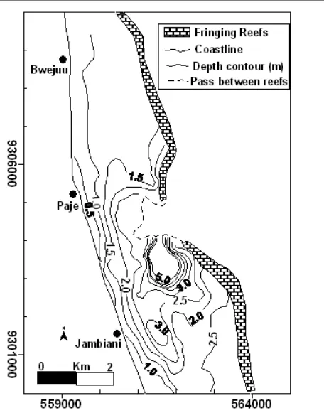
• Corrosion of reefs. This occurs if the acidity of the water increases. The entire coastal section between Jambiani and Paje is fringed by coral reefs, which are composed of carbonate rocks. The fringing reefs help to protect the beaches from erosion. With the increasing threats of acidification of ocean waters the carbonate rocks may slowly disappear and this would increase the vulnerability of the coast to erosion.
Socio-economic related issues
• According to Yanda (2011) women and men are affected differently by altering roles and tasks they perform. Women may for instance need to travel long distances searching for water and firewood. The degrading of freshwater supply due to sea water intrusion would likely have significant impacts to women than to me. Furthermore, with the increasing threats of people losing their assets and becoming poorer from various natural hazards such as floods, drought and erosion along the beach the women are expected to be mostly affected.
Summary of observed changes
In view of the presented findings (gathered from the scientific point of view and local community perceptions), shoreline erosion is one of the biggest environmental problem facing the two villages (Jambiani and Paje).The shoreline erosion problem is both naturally induced and human induced (Table 2; Appendix 2).
Human Impacts Natural Causes
Seagrass degradation Hurricanes
Increase in sea urchins Spring Tides
Cutting trees along the coast and removal of grass for drying seaweed
Increase in Rain
Passages on the sea bed through trampling Strong Waves
Biodiversity reduction Strong Winds
Destruction of reefs from bad fishing practices Tsunami Uncontrolled building along the coast or building too close to
the coast
Disappearance of some type of fish and elasmobranches e.g. manta ray
Digging holes for garbage disposal Salt intrusion in wells
Sand mining Sea level rise
Seaweed farming Increase in water temperature
Over collection of some gastropds e.g. Capreacassis ruffa Coral bleaching Predation. Coral diseases
Lack of environmental education Sedimentation
Bait digging Floods
Failure to abide by laws and regulations Too much rain causing floods in certain areas Cleaning the natural grasses (by hoteliers) brought in by waves
Throwing of garbage in the ocean Increase in number of tourists
Unawareness of the laws and regulations by villagers Diving, fishing and passenger boats
Dumping of waste along the coast and nutrient enrichment
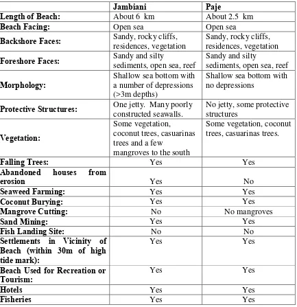
Table 3. Physical and socio-economic setting of the two villages Jambaini and Paje, Zanzibar
Jambiani Paje
Length of Beach: About 6 km About 2.5 km
Beach Facing: Open sea Open sea
Backshore Faces: Sandy, rocky cliffs, residences, vegetation Sandy, rocky cliffs, residences, vegetation
Foreshore Faces: Sandy and silty sediments, open sea, reef Sandy and silty sediments, open sea, reef
Morphology: Shallow sea bottom with a number of depressions (>3m depths)
Shallow sea bottom with no depressions
Protective Structures: One jetty. Many poorly constructed seawalls. No jetty, some protective structures
Vegetation:
Abandoned houses from
erosion Yes No
Seaweed Farming: Yes Yes
Coconut Burying: Yes Yes
Mangrove Cutting: No No mangroves
Sand Mining: Yes Yes
Beach Used for Recreation or
Tourism: Yes Yes
Hotels Yes Yes
4.4 Adaptive Capacity of Paje and Jambiani Villages
Climate change is considered to be one of the most serious threats to sustainable development, with adverse impacts expected on the environment, human health, food security, economic activity, natural resources and physical infrastructure. While mitigation has traditionally been the pivotal issue for many climate change experts, adaptation to the effects of climate change is now acknowledged as necessary for responding effectively and equitably to the impacts of both climate change and climate variability. Although the capacity of individuals to adapt to climate change is a function of their access to resources, the adaptive capacity of societies depends on the ability to act collectively in the face of the threats posed by climate variability and change. In Paje and Jambiani there are several activities on going to enhance the adaptive capacity of the communities in both Paje and Jambiani through various awareness programmes. Also the community has mobilized themselves to form committees to manage their coastal resources through replanting of Ipomea as well as mangroves as a first step to reduce the observed impacts.
Adaptive Capacity Questions (similar in both villages) Paje and Jambiani
How well do community members work together on coastal development
planning and coastal management, including coastal hazards?
Each village has community based organizations responsible for overseeing various activities e.g. mangrove management committee, environmental committees, and fisheries committees. Work is done on a volunteer basis.
What practices are currently employed to cope with natural hazards? Who is responsible for developing and implementing such measures?
There is a Department of Environment which is responsible on proper control of the environment. Also there is the National Adaptation Programme of action (NAPA) run from SMOLE (Lars, 2010). They provide training in preparedness and resilience initiatives There is also the Disaster Management Department (2nd Vice Presidents Office) mandated to coordinate national efforts in response to emergence situations. The Department plays vital role in ensuring community protection against natural hazards.
Are decision-makers and the community in general informed and engaged?
Adaptive Capacity Questions (similar in both villages) Paje and Jambiani
Do most people rely on the same activity for their livelihoods? For example, does everyone rely on fishing or agriculture, such that a single event could destroy their livelihoods of many in the community?
Most people have more than two livelihood activities. Most fishers are also farmers. Most seaweed farmers also do other activities when they can not go into the oceans during neap tides.
In an emergency, are there multiple means of communicating or transporting people and supplies? Or will damage to a single road or bridge isolate the community?
There are good communication and transporting systems in most areas having quick links to various places
How healthy are the ecosystems and how well are natural resources managed?
The major ecosystems such as corals, mangrove and seagrass in these areas are partially destroyed but in most cases they are still in good condition. One
5. ADAPTATION OPTIONS AND RECOMMENDATIONS
5.1 Key Actions Suggested by the Communities
Each village formed special committees were to address follow-up actions. The committees took on the responsibility for overseeing the planting of Ipomea along the beach to control erosion. Also other recommendations were provided as follows. The overarching emphasis by the communities was on actions they could carry out within their own abilities and efforts.
• Awareness programmes need to be conducted to inform the community on the issue of climate change and exchange experiences
• Laws and regulations should be revised to consider the issue of climate change
• Improve enforcement of building rules and regulations along the coast
• Meetings involving hoteliers, relevant government institutions and the community need to be held as these people rarely have an opportunity to meet. The aim of the meetings would be to discuss how together they can tackle the problem of erosion.
• Encourage planting of Ipomea along the coastal strip
• Find alternative drying techniques for the seaweed farmers to eliminate drying on the
Ipomea grass
• The local government needs to find alternative inland locations for sand mining so as to promote the elimination of beach sand mining
• Put in place government preparedness measures to address disasters
5.2 Promotion of Good Shore Management Practices
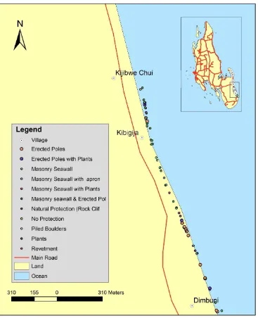
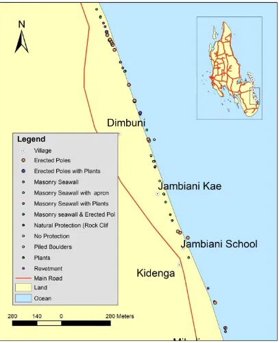
The GIS inventory of the existing coastal protection measures along the entire Jambiani – Paje revealed that masonry seawalls were the most common coastal protection measures (Figure 8). The masonry seawalls were generally vertical and either without any other supplementary protection or with additional supplementary protections such as quarried rock aprons or indigenous plants. Other less common protection measures were natural protection, erected poles and piled boulders. Plants and revetment protection were rare.
were demonstrated (Figure 9). Committees of 10 and 13 people were formed at Paje and Jambiani respectively for promoting good shore management practices.
EXAMPLE TYPE OF PRACTICE
(a) = a vertical masonry seawall (one of the observed bad shore management practice),
(b) = revetment (one of the two observed good shore management practices)
(c) Ipomea creeping plants (one of the two observed good shore management practices)
6. CONCLUDING OBSERVATIONS
There have been several benefits of doing coastal management work prior to the vulnerability assessment in the case of Paje and Jambiani. The IMS assessment team became familiar with the site, and it was easy to plan and organize meetings because the communities already knew the team. It was also easy to meet with the community since they already knew what they wanted from us, they understood us, and could talk with us. The village head had also built trust with the assessment technical team. We had already become familiar with the area. So when they mentioned the names of certain areas it was easy for us to picture what they were talking about.
In the previous coastal management planning, IMS worked with the scientists and the community separately to gather information. But what we found was that there was a high degree of convergence between the observations of both groups, one using its life experience and the other using the tools of science and scientific data. The community has very detailed and accurate information on the environment. One of the implications of this is when working in new villages along the coast it would be wise to bring some community members along with the technical team, to speed up the process of orienting a new village to the issue of climate change and the methods for doing the assessment. It would be expected that understanding and confidence would emerge much more quickly when peers are sharing their ideas and experiences.
In Paje and Jambiani, most understood that there are ongoing changes in climate. Some people knew about climate change and vulnerability because they were able to talk about observed changes in temperature of sea water, disappearance of some fish species, and changes in fish distribution. Also, they knew that salt water intrusion is occurring in some wells. However, there are invariably some who mix up weather and climate, noting perhaps that since it was windy two days ago that it was attributable to climate change.
REFERENCES
Construction Industry Research And Information Association (CIRIA). (1996) Beach Management Manual. CIRIA Report 153. Construction Industry Research and Information Association, London. 448pp.
Combes, Stacey. (2005). Climate change threatens fish and fisheries as temperatures rise in oceans, lakes and rivers. WWF, the global conservation organization, Gland, Switzerland.
Know Climate Change. (2012). Definitions of adaptation and mitigation. http://know.climateofconcern.org/index.
Mazzilli, S. ; Hills, J.;Jiddawi, N.S. Nyandwi, N.; Shaghude. Y. Sanga.I.; Babu M. T.; Sudheesh K.; Kyewalyanga, M and Ehrlich, D. (2010).The participatory approach to coastal management at Jambiani, Zanzibar. Using Decision Support Tools: Good practice for coastal management. UNESCO/IOC/IMS/ RECOMAP/EU, 12 p.
Møller, Lars. (2010).Adaptation to Climate Change. Programme of Action for Zanzibar Sustainable Management of Land and Environment II, (SMOLE II) 2010-2013 NIRAS .pp 45
Shaghude,Y.W., Mburu,J.W, Arthurton, R.S. , Dubi, A., Gachuiri,S., Kangwe, J.,
Magori,C., Msuya, F., Mwaipopo,R., Nyandwi, N., Ochiewo, J., Ong’anda,H., Sallema,R., Sanga, I., Shalli, M., Uku, J. (2010). Shoreline change in Tanzania and Kenya: Assessment procedures and mitigation strategies for management. 88 p., submitted, Western Indian Ocean Journal of Marine Science.
Watkiss, P., Maclean, A., Pye, S., Hendriksen, G., Maclean, A., Bonjean, M., Jiddawi, N., Shaghude, Y., Sheikh, M.A. and Khamis, Z. (2012). The Economics of Climate Change in Zanzibar, Final Summary Report, July 2012. Global Climate Adaptation Partnership, funded by UK AID from the Department for International Development, 35 p. http://economics-of-cc-in-zanzibar.org/images/Impacts_vulnerability_and_adaptation_vs_3.pdf
0
Appendix 1: Questionnaire Results, Perception of Environmental Change
Figure10. Perceived environmental changes by the communities ( n= 64)
Figure 11. Responses on what should be done by the community in relation to the changes along the beach ( n= 64)
Appendix 2: Photos Depicting Erosion and Coastal Activities at Paje and Jambiani
Erosion and coastal activities at Paje and Jambiani
Large stones from a fallen wall at Jambiani Eroded beach at Jambiani
Erosion and coastal activities at Paje and Jambiani
Seaweed farming at Paje
Women busying coconut husks at Jambiani
Planting of Ipomea grass to control erosion at Paje beach
A layer of seagrass mixed with algae washed from the sea