SITE INVESTIGATION FOR CONSTRUCTION OF
EMERGENCY SPILLWAY AT THE JATIGEDE
DAM
Gusti Warman and I Gde Budi Indrawan∗
Geological Engineering Department, Faculty of Engineering, Gadjah Mada University, Yogyakarta, Indonesia
Abstract
An emergency spillway has been planned to be con-structed at the Jatigede Dam, West Java, to allow floodwater to flow downstream and to prevent the capacity of the main spillway to be exceeded dur-ing large flood events. The complex geology of the Jatigede Dam area, however, poses a challenge to de-termine the suitable location for the emergency spill-way construction, either in the area to the west or to the east of the embankment dam. An engineer-ing geological mappengineer-ing and landslide susceptibility zoning were conducted to determine the engineering geological characteristics of the area surrounding the Jatigede Dam. The site investigation showed that the area to the west of the embankment dam tended to have a lower slope inclination than the area to the east of the embankment dam. Both areas to the west and to the east of the embankment dam were found to be composed of less erosion resistant rock units. The existence of the earth retaining structures for slope stabilization in the area to the east of the embank-ment dam will, however, likely limit the flexibility in developing the emergency spillway route. With re-spect to the existence of fault systems, both areas to the west and to the east of the embankment dam will likely be influenced by similar conditions. The area to the west of the embankment dam tended to be less susceptible to landslide as compared to the area to the east of the embankment dam. The undeveloped land use of the area to the west of the embankment
∗Corresponding author: IG.B. INDRAWAN,
Geolog-ical Engineering Department, Faculty of Engineering, Gadjah Mada. Jl. Grafika 2 Yogyakarta, Indonesia. E-mail: [email protected]
dam as compared to the area to the east of the em-bankment dam will provide more flexibility in con-struction of the emergency spillway. Due to the more favorable engineering geological conditions, the area to the west of the embankment dam is proposed for the location of the emergency spillway construction. Keywords: Emergency spillway, Engineering geo-logical mapping, Jatigede Dam
1 Introduction
A spillway is an essential feature of a dam that is constructed to pass flood water safely down-stream when the reservoir is overflowing (No-vaket al., 2007). Dams typically consist of two spillways, which are main and emergency spill-ways. The main spillway maintains normal wa-ter level in the reservoir. Meanwhile, the emer-gency spillway is designed to operate during emergency conditions, particularly when the main spillway fails to fully operate during ex-treme flood events or when the capacity of the main spillway has been exceeded, to prevent overtopping of the dam.
11,000 m3/s probable maximum flood (PMF) discharge (PT. Indra Karya Consulting Engi-neer, 2013). Maximum discharge capacity of the main spillway is about 58.76% of the total discharge capacity. When all four or, at least, three gates of the main spillway operate in max-imum flood events, the water level of reservoir is expected to be under the freeboard. How-ever, when only two gates operate normally in maximum flood events, the water level of reser-voir is estimated to exceed the freeboard. To ensure the safety of the embankment dam dur-ing extremely large flood events, an emergency spillway is, therefore, required.
The possible locations for the emergency spillway construction are around the periph-ery of the water reservoir, either in the area to the west or to the east of the embankment dam. The flood water is then released to the Cimanuk River downstream behind the em-bankment dam. As the Jatigede Dam and the surrounding area are composed of complex geology (Makmur, 2013), a detailed site char-acterization is required to ensure the planned emergency spillway will not be affected by the existing and future geological conditions.
The Jatigede Dam area is located at the ern part of Bogor Anticlinorium having an east-west fold axis (van Bemmelen, 1949). Ac-cording to the Regional Geological Map of the Arjawinangun Sheet (Djuri, 1995), the oldest rock unit deposited in the research area was a sandstone intercalated with shale of the Up-per Oligocene to Oligo-Miocene Cinambo For-mation. Subsequently, it was deposited a vol-canic breccia of the Lower Part of the Lower to Upper Miocene Halang Formation, a clay-stone of the Upper Part of the Lower to Up-per Miocene Halang Formation, a claystone in-tercalated with tuffaceous sandstone of the Up-per Part of the Lower to UpUp-per Miocene Halang Formation, a tuff breccia of the Lower Quarte-nary Folded Breccia Formation, a volcanic brec-cia of the Middle Quartenary Undifferentiated Old Volcanic Products, and a clayey sand of the Recent Alluvial and Talus Deposits. In ad-dition to the complex lithologies, the Jatigede Dam area has also a complex tectonic history (Makmur, 2013).
This paper presents results of site investiga-tion to determine the most suitable locainvestiga-tion for construction of an emergency spillway at the Jatigede Dam. The engineering geological char-acteristics of the areas to west and to east of the embankment dam are presented and compared.
2 Methodology
An engineering geological mapping was con-ducted to determine the engineering geolog-ical characteristics of the areas surrounding the embankment dam. Data of morphology, soil and rock physical and engineering prop-erties, geological structure, seepage, vegeta-tion, and land use were collected during the site investigation and drawn in 1:25,000-scale topographic maps. Rock weathering degrees were determined following the classification by ISRM (1981). Data of rainfall and earthquake frequency were collected from existing reports of previous site investigations. A landslide susceptibility zoning was then conducted fol-lowing the Regulation of Indonesian Minister of Public Works No. 22/PRT/M/2007 (De-partemen Pekerjaan Umum, 2007). Two groups of landslide-controlling parameters are consid-ered in the regulation, which are natural condi-tions and human activities. However, the pa-rameters of natural conditions were only con-sidered in this research since human activities in the area surrounding the embankment dam were relatively low. The landslide-controlling parameters used in the landslide susceptibility zoning included slope inclination, soil cover, rock slope, rainfall intensity, seepage, earth-quake frequency, and vegetation. Each of those landslide-controlling parameters was given a different susceptibility weight and classified into a 1, 2, or 3 susceptibility class, indicating a low, moderate, or high class of susceptibility to landslide, respectively. A susceptibility in-dex of each parameter to landslide was then cal-culated by multiplying the weight by the class. The rating criteria in the landslide susceptibility zoning are shown in Table 1.
Table 1: Rating criteria in landslide susceptibility zoning (Departemen Pekerjaan Umum, 2007).
of susceptibility to landslide. The vegetation existing in the research area consisted of trees having needle-like leaves and coarse grasses, weeds, and scrubs, and could be categorized into moderate and high classes of susceptibility to landslide, respectively. Meanwhile, the con-ditions of rainfall, seepage, and earthquake fre-quency were relatively uniform in the research area. The annual rainfall in the Cimanuk Wa-tershed ranged from 1900 mm to 4200 mm (PT. Indra Karya Consulting Engineer, 2013) and, therefore, the parameter in the research area could be classified into a moderate class of sus-ceptibility to landslide. No seepage or spring was observed in the research area and, there-fore, the parameter could be classified into a low class of susceptibility to landslide. The earthquake in the research area had been rel-atively infrequently (Sobirin, 2005; Joneset al., 2014) and the parameter could be classified into a moderate class of susceptibility to landslide.
A total susceptibility index was calculated by summing the susceptibility indices of all pa-rameters using the overlay method in the
geo-graphic information system (GIS). The total sus-ceptibility index of 1.00 to 1.69, 1.70 to 2.39, and 2.40 to 3.00 indicated low, moderate, and high classes of susceptibility to landslide, respec-tively. The engineering geological characteris-tics, particularly the morphology, engineering properties of the soil cover and rock, geological structure, susceptibility to landslide, and land use, of the areas to the west and to the east of the embankment dam were then compared qualita-tively for determination of the most suitable lo-cation for of the emergency spillway construc-tion.
3 Results and Discussions
Figure 1: Slope inclination map of the research area.
and the blue dash line lies to the south of the embankment dam shown in the map is the planned reservoir boundary. In the area to the west of the embankment dam, the slope incli-nation ranged from 3 to 20%, while in the area to the east of the embankment dam, the slope inclination ranged from 14 to 55%. With respect to the topography, an emergency spillway con-structed in the area to the east of the embank-ment dam will likely suffer more severe erosion that that in the area to the west of the embank-ment dam due to a higher hydraulic gradient. Erosion of unlined earthen emergency spillway may cause failure of spillway structures and catastrophic release of reservoir waters, spill-way channel bank failure, and sedimentation in the spillway exit and main channel (Cameronet al., 1990).
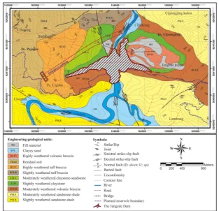
The engineering geological units compos-ing the research area are shown in Figure 2. The sandstone intercalated with shale of the Cinambo Formation exposed in the areas to the south and north-east of the embankment dam could be distinguished into the slightly weathered sandstone-shale (PSLR) and mod-erately weathered sandstone-shale (PSLS) unit (Figure 3). Both units were highly fractured. The slightly weathered sandstone-shale unit had a 36.9-108.9 kgf/cm2 unconfined compres-sion strength (UCS) value (Makmur, 2009). The moderately weathered volcanic breccia (BVLR) unit of the Lower Part of the Halang Formation, which was largely exposed in the area to the east of the embankment dam, was highly frac-tured and had a 60-95% rock quality designa-tion (RQD) value and a 69.1-127.2 kgf/cm2UCS value (Makmur, 2009) (Figure 4a). The slightly weathered claystone (LLR) unit of the Upper Part of the Halang Formation, which was ex-posed in the areas to the east and north-west of the embankment dam, and the mod-erately weathered claystone-sandstone (LPLS) unit of the Upper Part of the Halang Formation, which was exposed in the area to the north-west of the embankment dam, were also fractured (Figure 4b and Figure 4c–d). The claystone unit is essentially impermeable to water flow. Due to weathering and fracturing, however, the rock unit generally had up to 5 Lugeon
permeabil-Figure 3: Moderately weathered and fractured sandstone-shale (LPLS) of the Cinambo Forma-tion.
ity value (Makmur, 2009). The slightly weath-ered tuff breccia (BTLR) and highly weathweath-ered tuff breccia (BTLT) units of the Folded Brec-cia Formation exposed in the area to the west of the embankment dam had a 0-100 Lugeon permeability value, where the upper range of permeability value was the characteristics of the highly fractured and weathered tuff brec-cia unit (Makmur, 2009) (Figure 4e). The resid-ual soil (TRLB) unit in the top left corner of the map was essentially a weathering product of the tuff breccia of the Folded Breccia Forma-tion and had up to a 40 kgf/cm2 UCS value (Makmur, 2009). The clayey sand (EPL) unit of the unconsolidated Alluvial and Talus Deposits was exposed in the area along the river. The fill material (MU) unit located to the east of the embankment dam partly covered the area un-derlain directly by the highly weathered vol-canic breccia (BVTT) unit of the Undifferenti-ated Old Volcanic Products (Figure 4f). The fill material (MU) unit was essentially a geogrid re-inforced soil and a graded soil foundation of gabion gravity retaining walls for slope stabi-lization and erosion control. The earth retain-ing structures were installed in the area com-posing of the highly weathered volcanic breccia (BVTT) unit because the area had been very sus-ceptible to landslide, as discussed in the para-graph of landslide susceptibility zoning below.
in the area to the west of the embankment dam will likely cut through the highly ered tuff breccia (BTLT), moderately weath-ered claystone-sandstone (LPLS), and slightly weathered claystone (LLR) units. The highly weathered tuff breccia (BTLT) unit will likely be vulnerable to erosion by flood water. Mean-while, an emergency to be constructed in the area to the east of the embankment dam will likely cut through the slightly weathered clay-stone (LLR), highly weathered volcanic breccia (BVTT), and fill material (MU) units. The highly weathered volcanic breccia (BVTT) and fill ma-terial (MU) units will likely be vulnerable to erosion by flood water. Although both areas composed of less erosion resistant rock units, the existence of fill material (MU) units and the earth retaining structures in the area to the east of the embankment dam will likely limit the flexibility in developing the emergency spill-way route. In other words, the area to the west of the embankment dam is more favorable for construction of the emergency spillway.
Figure 2 also shows a number of faults existing in the research area, including the large north-south strike-slip faults along the Cimanuk River and perpendicular to the em-bankment dam. With respect to the existence of fault systems, both areas to the west and to the east of the embankment dam will likely be influenced by similar conditions. Although the existing faults in the research area are not active faults (PT. Indra Karya Consulting Engineer, 2013), caution must be taken when an unlined emergency spillway to be constructed crossing the strike-slip fault at the contact between the slightly weathered claystone (LLR) and mod-erately weathered claystone-sandstone (LPLS) units in the area to the west of the embankment dam or crossing the normal fault cutting the highly weathered volcanic breccia (BVTT) unit of the Undifferentiated Old Volcanic Products in the area to the east of the embankment dam since the fault zones may induce uncontrolled seepage.
Figure 5 shows the landslide susceptibility zones in the research area. In general, the result of the landslide susceptibility zoning obtained from this research is in a reasonably agreement
with the Regional Map of Landslide Suscepti-bility Zone of Arjawinangun Sheet (Sugalang and Sugiyanto, 1994), which indicates that the Jatigede area is located in the moderate to high susceptibility to landslide. The hilly areas of the research area are characterized by a moderate to high class of susceptibility to landslide, while the river valleys are characterized by a low class of susceptibility to landslide. Figure 5 also shows that the previous landslides occurred mainly in the high susceptibility zones, imply-ing a reasonably high accuracy of landslide pre-diction using the adopted method. The slope inclination and material engineering properties appear to dominantly control the susceptibility of the research area to landslide.
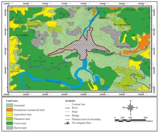
In the area to the west of the embankment dam, the relatively steep slopes along the Cimanuk River were highly susceptible to land-slide (Figure 5). Meanwhile, in the area to the east of the embankment dam, the hilly area composed of the highly weathered volcanic breccia (BVTT) unit of the Undifferentiated Old Volcanic Products was highly susceptible to landslide. Landslide may cause damage to the emergency spillway structure or block the emergency spillway channel and those two zones of high susceptibility to landslide should be avoided for construction of the emergency spillway. However, since the area to west of the embankment dam had relatively a smaller number of landslide cases and less area of high susceptibility to landslide than the area to the east of the embankment dam, the area to west of the embankment dam is likely more favorable for construction of the emergency spillway.
Figure 5: Landslide susceptibility map of the research area.
the area to the west of the embankment dam provided more flexibility in construction of the emergency spillway.
Considering the more favorable engineer-ing geological characteristics, particularly the morphology, engineering properties of the soil cover and rock, geological structure, suscep-tibility to landslide, and land use, the emer-gency spillway is, therefore, proposed to be constructed in the area to the west of the em-bankment dam, as shown in Figure 2. The nearly straight emergency spillway route is ex-pected to take the flood water shortly to the Cimanuk River downstream behind the em-bankment dam.
4 Conclusions
A site investigation involving an engineering geological mapping and landslide susceptibil-ity zoning was conducted to determine the en-gineering geological characteristics of the areas to the west and to the east of the Jatigede Dam. The area to the west of the embankment dam tended to have a lower slope inclination than the area to the east of the embankment dam. Both areas to the west and to the east of the
Figure 6: Land use map of the research area.
Acknowledgements
The research was supported by Department of Geological Engineering Universitas Gad-jah Mada and Balai Besar Wilayah Sungai (BBWS) Cimanuk-Cisanggarung. The first author wishes to thank the BBWS Cimanuk-Cisanggarung for the opportunity to do the research. The assistance of Mr. Dwi Agus Kun-coro and Mr. Anwar Makmur of the BBWS Cimanuk-Cisanggarung is gratefully acknowl-edged.
References
Cameron, C.P., Patrick, D.M., May, J.H., Palmer-ton, J.B., McAneny, C.C., Hatheway, A.W., Bartholomew, C.O., Mathewson, C.C., and Cato, K.D. (1990) Geotechnical Aspects of Rock Erosion in Emergency Spillway Chan-nels. Report 5: Summary of Results, Con-clusions, and Recommendations. US Army Corps of Engineers.
Departemen Pekerjaan Umum (2007) Pedo-man Penataan Ruang Kawasan Rawan Ben-cana Longsor. Peraturan Menteri Pekerjaan
Umum No.22/PRT/M/2007. Departemen
Pekerjaan Umum, Direktorat Jenderal Pe-nataan Ruang, Jakarta, p.15-43.
Djuri (1995) Peta Geologi Lembar Arjawinan-gun, Jawa Barat, Skala 1 : 100.000. Direktorat Geologi Bandung, Bandung.
Jones, E.S., Hayes, G.P., Bernardino, M., Dan-nemann, F.K., Furlong, K.P., Benz, H.M., Vil-lasenor, A. (2014) Seismicity of the Earth 1900–2012 Java and Vicinity, U.S. Department of the Interior, U.S. Geological Survey, Open-File Report 2010–1083-N.
ISRM (1981) Basic Geotechnical Description of Rock Masses. International Journal of Rock Mechanics Mining Sciences and Geomechan-ics Abstracts, 18, pp. 85-110.
Makmur, A. (2009) Rock Foundation Excava-tion in Case at Jatigede Dam. A Project Re-port, p. 2-4.
Makmur, A. (2013) Pengaruh Struktur Ge-ologi Terhadap Mutu Batuan Pondasi
Ben-dungan Jatigede. SNVT Pembangunan
Waduk Jatigede, Direktorat Jenderal Sumber Daya Air, Kementerian Pekerjaan Umum, Sumedang, p. 2-15.
PT. Indra Karya Consulting Engineer (2013) Pe-mantauan dan Kajian Penggenangan Waduk Jatigede (Paket 30). Laporan Triwulan: Ke-menterian Pekerjaan Umum, Direktorat Jen-deral Sumber Daya Air, Balai Besar Wilayah Sungai Cimanuk-Cisanggarung, Sumedang.
Sobirin (2005) Penolakan Pembangunan Waduk Jatigede dan Pemulihan DAS di Jawa Barat, DPKLTS, Bandung.
Sugalang, U.B. dan Sugiyanto (1994) Peta Zona Kerentanan Gerakan Tanah Daerah Arjaw-inangun dan Sekitarnya, Jawa Barat, Skala 1 :
100.000, Direktorat Vulkanologi dan Mitigasi Bencana Geologi, Bandung.
van Bemmelen, R.W. (1970) The Geology of In-donesia Vol. 1 A. General Geology of Indone-sia and Adjacent Archipelagoes, 2nded., Gov-ernment Printing Office, The Hauge, Amster-dam, p. 645-653.