Mapping of Tree Damage Classification in the Western Part
of Medan City Green Belts Using Geographic Information
System
Rahmawaty
1*, I E P Sembiring
1, R Batubara
1and P Patana
1 Forestry Study Program, Faculty of Forestry, University of Sumatera Utara Jl. Tri Dharma Ujung No. 1 Kampus USU, Medan 20155, IndonesiaEmail:[email protected]
Abstract. The existence of trees in the cities is very important. Trees play an important role as an absorber of CO2and a storage facility for carbon (C). This study aimed to classify and map the tree damage in the Western Part of Medan City Green Belts. The experiment was conducted using the Forest Health Monitoring (FHM) and the classification of tree damage classes was determined based on the scoring of index values based on USDA Forest Service. The results showed that there were 46 very healthy trees, 976 healthy trees, 1114 lightly damaged trees, 167 medium trees and 9 dead trees. The level of tree damage was dominated by the lightly damaged trees class. If the health of the tree is well preserved, then the tree can perform its function properly. Therefore, it is necessary to carry out this research to provide important information about the damage of the trees then it can be used as a reference for the proper trees care activities.
1. Introduction
Medan City is the third largest city in Indonesia. As a metropolitan city, Medan experiences constant transportation activity. Therefore, the existence of trees in the cities is extremely important. Trees have the ability to reduce air pollutants [1]. One of the city government efforts to create comfort in Medan City is to build a green belt along the main and secondary roads. The green belts were located either along the edges or median strips of roads or solely along the edges of the road. Green belts along median strips function to assist steering along the road, to assist forming views and restricting glare from other vehicles; those on the edges of roads serve as pollution-absorbent, shade-providing and noise-cancelling barriers as well as wind breakers [1-5]. The primary requirements for landscaping plants in streets as stipulated by the Regulation of the Ministry of Public Works (1996) No. 033 are (1) their roots do not damage the road construction, (2) they are easy to maintain, (3) their stems and branches are not easily broken, (4) their leaves do not easily shed and (5) they are safe and offer comfort to motorists and other road users [1].
Tree damage classification in the Western Part of Medan City Green Belts can implement Mangold modification concept [6]. Trees as the main object of the composition of green belt are expected to be guaranteed its health to provide a sense of security and comfort for the community. The tree damage in the Western Part of Medan City Green Belts can be presented in the form of maps using Geographic Information System (GIS) technology. The GIS is a system-oriented operation relating to the conventional collection, storage and manipulation of referenced geographical data by computers (hardware and software) capable of handling this data. Among other functions of such mapping is the capacity to show the spatial distribution of geographical phenomena, including the nature and characteristics of their different positions on the surface of the
earth [7].
GIS system can be developed a multi techniques and used to compared the field trees mapping survey result accuracy, not just for display a map field data survey result only[8,9]
. The model can be develop using another indirect factor such as pixel and whole tree scale, vegetation index, AVIRIS or NDVI statistical analysis[10].
Since information regarding the tree damage in the Western Part of Medan City Green Belts is lacking, conducting this research is of great importance. This study aimed to classify and map the tree damage in the Western Part of Medan City Green Belts. This study is expected to provide information that will assist the government in Medan City in determining a management plan for the environmental development of Medan City.
2. Data and Method
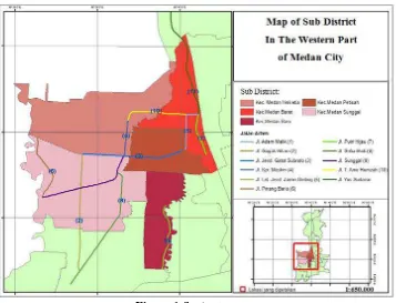
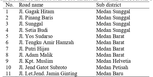
This study was conducted from April to October 2016 in the Western Part of Medan City Green Belts. This research was conducted in 11 main roads that were located in five sub-districts, namely: Medan Barat, Medan Baru, Helvetia, Medan Petisah and Medan Sunggal (Figure 1 and Table 1).
Table 1.Name of the road at five sub district in WesternPart of Medan City
No. Road name Sub district
1 Jl. Gagak Hitam Medan Sunggal
2 Jl. Pinang Baris Medan Sunggal
3 Jl. Sunggal Medan Sunggal
4 Jl. Setia Budi Medan Sunggal
5 Jl. Yos Sudarso Medan Barat
6 Jl. Tengku Amir Hamzah Medan Barat
7 Jl. Putri Hijau Medan Barat
8 Jl. Adam Malik Medan Barat
9 Jl. Kpt. Muslim Medan Helvetia
10 Jl. Jend Gatot Subroto Medan Petisah 11 Jl. Let.Jend. Jamin Ginting Medan Baru
The green belts for each sub-district of Medan City were determined using a purposive sampling technique. A tree inventory was compiled for all tree species (via a census method) located in the selected green belts.The GPS was used to record the coordinate points of the trees and GIS was used to analyse the distribution of the tree damage in green belts
[11].
The experiment was conducted using the Forest Health Monitoring (FHM), which is monitoring forest stand conditions to analyse the present and the future, and provide recommendations for improving management. The classification of tree damage classes was determined based on the scoring of index values[12].The 12 codes and damages type, 10 codes and locations of damage, 10 codes and classes of severity of damage and weights of tree damage index alsorefers toindex values [12].
Damage assessment used criteria based on the FHM method[6,13,14].Data obtained from the damage assessment was calculated by Damage Index Value (DIV) with the code and the weight of the DIV.Damage assessment calculation (1) used criteria based on previous study [6,13,14], namely:
= ( Xi. Yi. Zi) (1)
Where:
DIV : Damage Index Value at the tree level Xi : The weight value on the type of damage
Yi : The weight value on the part / location of the damaged tree Zi : The weight value on the severity of the damage
The class of damage for the tree based on the weight of the index value with the following criteria: healthy class: 0 - <5, class of lightly damage: 6 – 10, medium damage class: 11-15, and class of heavy damage: 16 - > 21. The final calculation results (DIV) was classified as: healthy class, lightly class, medium class and heavy class.
3. Results and Discussion
in accordance to the resultsof previous study [11,15],followed bySwietenia macrophylla(20.66%) andSwietenia mahagoni(17.59%).
Table 2. Tree species found at the study site
No. Name of tree Scientific name Number of tree Percentage
1 Angsana Pterocarpus indiscus 1264 54.71%
2 Mahoni Swietenia mahagoni 407 17.59%
3 Mahoni daun lebar Swietenia macrophylla 478 20.66%
4 Mangga Mangivera indica 9 0.39%
5 Tanjung Mimusops elengi 9 0.39%
6 Glodokan Polyalthia longifolia 60 2.59%
7 Sengon Paraserianthes falcataria 1 0.04%
8 Melur Podocarpus elongates 1 0.04%
9 Petai cina Leucaena leucocephala 7 0.30%
10 Saga Adenathera pavonina 14 0.61%
11 Asam jawa Tamarindus indica 55 2.38%
12 Beringin Ficus benjamina 3 0.13%
13 Waru Hibiscus tiliaceus 4 0.17%
Total 2313 100.00%
There are 10 types of damage from 13 types of damageproposed by previous study [6]. Of the 10 types of damage (Figure 2), the most common type of damage was vandalism (34%), due to research conducted in urban areas with many advertising activities, such as: sticking banners using nails or wire. The result is in contrast to previous study [16] which found that the most damage type was further decay of the trees. This is because the research was conducted in the Bogor Botanical Gardens where the trees were old.
Figure 2. Percentage of damage type
The percentage of tree damage types can be observed in Figure 3. A total of 2,312 individual trees on 11 arterial roads found in 5 sub-districts in Medan City, the most affected part of trees was on the bottom of stem (41%), because it was easily accessible to humans.In contrast to previous study [16],
the most commonly found tree parts are in the root and stump part, because many trees were old and easily fallen.
Figure 3.Percentage of damage location
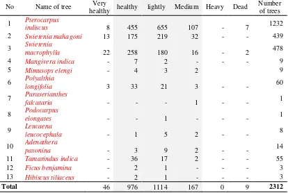
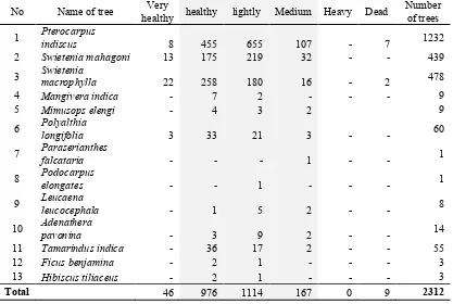
There were three tree damage classifications in the Western Part of Medan City Green Belts, namely: healthy, lightly damaged, and medium trees. Heavy damage classification was not found in the western part of Medan City Green Belts (Table 3).Pterocarpus indicuswas dominant tree in the study sites (1,232 individual trees). A total of 655 individuals were classified as lightly damage. A total of 455 individuals were healthy and 107 individuals trees were classified as medium.
Table 3. Damage classes based on tree types Roots (open) and
healthy healthy lightly Medium Heavy Dead
Number of trees
1 Pterocarpusindiscus
8 455 655 107 - 7 1232
2 Swietenia mahagoni 13 175 219 32 - - 439
3 Swietenia
macrophylla 22 258 180 16 - 2 478
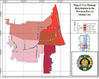
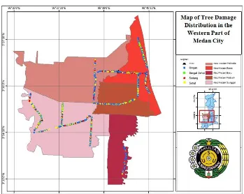
Based on FHM criteria, there were 976 healthy trees, 1114 lightly damaged trees, and 167 medium trees. The Percentage of Damage Class can be observed in Figure 4 while Map of Tree Damage Distribution on 11 arterial roads in Five Sub District in Medan City can be observed in Figure 5.
Figure 4.Percentage of damage class
Figure 5. Map of tree damage distribution on 11 arterial roads in five sub district in Medan city The level of tree damage was dominated by the lightly damaged trees class (Table 3and Figure 5). Based on these conditions, it will require intensive maintenance, such as watering and trimming. Another thing that that should be a concern in the area was vandalism (destructive trees) that was commonly found in the trees along the western part of Medan City Green Belts.
Very Healthy
2%
Healthy 42%
Lightly 48% Medium
7%
Heavy
0% Dead
4. Conclusion
There were three tree damage classifications in the Western Part of Medan City Green Belts, namely: healthy, lightly damaged, and medium trees. Heavy damage classification was not found in this location. The level of tree damage was dominated by the lightly damaged trees class. The most common type of damage was vandalism and most damage locations were found on the bottom of the stem.
Acknowledgement
We are grateful to the Indonesian Directorate General of Higher Education (DIKTI) and the University of Sumatera Utara (USU) for providing financial assistance, as well as to the organising committee of the7thInternational Symposium for Sustainable Humanosphere 2017, for supporting the presentation of this work on 1-2 November 2017, at the Salak Tower Hotel, Bogor. We also thank the students of the Faculty of Forestry at the USU (especially for Indra) who has assisted with field work.
5. References
[1] Rawat JS and Banerjee SP 1996 Urban forestry for improvement of environment Energy Environment Monitor.12 (2)109-116
[2] Ministry of Public Works 1996 Planning procedure of technique landscape road No. 033/TBM/1996.The Directorate General of Highways; Ministry of Public Works Jakarta.pp 58
[3] Sharma SC, Sharga and Roy RK 1994 Abatement of industrial pollution by landscapingIndian Journal of Environmental Protection.14(2)pp 95-97
[4] Nowak DJ, Stevens JC, Susan MS and Christopher JL 2002 Effects of urban tree management and species selection on atmospheric carbon dioxideJournal of Arboriculture.28113-121 [5] Rauf A, Rahmawaty and Syofyan A 2016 Technology-based land use for watershed
management.USU Press.pp26
[6] Mangold R 1997Forest Health Monitoring: Field Methods GuideUnited States Department of Agriculture Forest Service. Washington
[7] Prahasta E 2004 Geographic information system: Tutorial ArcView.CV. Informatika Bandung. pp456
[8]
Diem JE 2002 Remote Assessment of Forest Health in Southern Arizona, USA: Evidence
for Ozone-Induced Foliar Injury.
Environ.l Manage.
29
pp 373–384
[9]
Xiao QF 2005 Tree health mapping with multispectral remote sensing data at UC Davis,
California Urb. Ecosyst.
8
pp 349–361
[10]
Xiao QF, Ustin SL and Mc Pherson EG 2004 Using AVIRIS data and multiple-masking
techniques to map urban forest tree species.
Int. J. Remote Sens.
25
pp 5637–5654
[11]Rahmawaty, Sitorus NA and Rauf A 2017 Distribution, above-ground biomass and
carbon stock of the vegetation in Taman Beringin Urban Forest, Medan City, North
Sumatra, Indonesia.
The Malaysian Forester
80 (1)
pp 73-84
[12] USDA Forest Service 2001 Forest Health Monitoring to Monitor the Sustainability of-Indonesian Tropical Rain ForestSEAMEO BIOTROP. Indonesia
[13] Khoiri S 2004 Study of tree damage level in Srengseng Urban Forest, West Jakarta (Studi tingkat kerusakan pohon di Hutan Kota Srengseng Jakarta Barat). Thesis, Department of Forest Resource Conservation, Faculty of Forestry, Bogor Agricultural University (Skripsi Jurusan Konservasi Sumberdaya Hutan Fakultas Kehutanan Institut Pertanian Bogor). [14] Noviady I and Rivai R R 2015 Identification of shade plants health condition in
peneduh di Kawasan Ecopark. Cibinong Science Center-Botanic Gardens).
Proceedings of
National Seminar of Biodiversity Society of Indonesia
(Prosiding Seminar Nasional Masyarakat Biodiversity Indonesia).1(6)pp 1385-1391No Part (line) Reviewer evaluation Authors response (Modification)
· Jawaban author dan atau versi yang direvisi
· Pada naskah ditandai dengan warna font merah atau di highlight kuning
The result is in contrast to Miardini's study [12] Should be written as: The result is in contrast to previous study [12]
The classification of tree damage classes was determined based on the scoring of index values [12].
The 12 codes and damages type, 10 codes and locations of damage, 10 codes and classes of severity of damage and weights of tree damage index also refers to index values [12]. Pterocarpus indiscus was the dominant tree species found in the study site (54.71%) in accordance to the results of previous study [11,15], followed bySwietenia macrophylla (20.66%) andSwietenia mahagoni(17.59%).
There are 10 types of damage from 13 types of damage proposed by previous study [6].
Of the 10 types of damage (Figure 2), the most common type of damage was vandalism (34%), due to research conducted in urban areas with many advertising activities, such as: sticking banners using nails or wire. The result is in contrast to previous study [16]...
... In contrast to previous study [16], the most commonly found tree parts are in the root and stump part, because many trees were old and easily fallen.
Damage assessment calculation (1) used criteria based on previous study [6,13,14], namely:
assessment calculation (1) used criteria based ...
3 Line 98 Manuscript should be
written in English, please
all the Indonesian words have been translated
please see table 3 and references
4 Line 133 We can’t find Table 4 at
the manuscript draft.
The Correct one is Table 3
Mapping of Tree Damage Classification in the Western Part
of Medan City Green Belts Using Geographic Information
System
Rahmawaty
1, I E P Sembiring
1, R Batubara
1and P Patana
1 Forestry Study Program, Faculty of Forestry, University of Sumatera Utara Jl. Tri Dharma Ujung No. 1 Kampus USU, Medan 20155, IndonesiaE-mail: [email protected]
Abstract. The existence of trees in the cities is very important. Trees play an important role as an absorber of CO2 and a storage facility for carbon (C). This study aimed to classify and
map the tree damage in the Western Part of Medan City Green Belts. The experiment was conducted using the Forest Health Monitoring (FHM) and the classification of tree damage classes was determined based on the scoring of index values based on USDA Forest Service. The results showed that there were 46 very healthy trees, 976 healthy trees, 1114 lightly damaged trees, 167 medium trees and 9 dead trees. The level of tree damage was dominated by the lightly damaged trees class. If the health of the tree is well preserved, then the tree can perform its function properly. Therefore, it is necessary to carry out this research to provide important information about the damage of the trees then it can be used as a reference for the proper trees care activities.
1. Introduction
Medan City is the third largest city in Indonesia. As a metropolitan city, Medan experiences constant transportation activity. Therefore, the existence of trees in the cities is extremely important. Trees have the ability to reduce air pollutants [1]. One of the city government efforts to create comfort in Medan City is to build a green belt along the main and secondary roads. The green belts were located either along the edges or median strips of roads or solely along the edges of the road. Green belts along median strips function to assist steering along the road, to assist forming views and restricting glare from other vehicles; those on the edges of roads serve as pollution-absorbent, shade-providing and noise-cancelling barriers as well as wind breakers [1-5]. The primary requirements for landscaping plants in streets as stipulated by the Regulation of the Ministry of Public Works (1996) No. 033 are (1) their roots do not damage the road construction, (2) they are easy to maintain, (3) their stems and branches are not easily broken, (4) their leaves do not easily shed and (5) they are safe and offer comfort to motorists and other road users [1].
suffered by the constituent trees. Damages can be caused by diseases, insect pests, weeds, fire, weather, animals and human activities [6].
Tree damage classification in the Western Part of Medan City Green Belts can implement Mangold modification concept [6]. Trees as the main object of the composition of green belt are expected to be guaranteed its health to provide a sense of security and comfort for the community. The tree damage in the Western Part of Medan City Green Belts can be presented in the form of maps using Geographic Information System (GIS) technology. The GIS is a system-oriented operation relating to the conventional collection, storage and manipulation of referenced geographical data by computers (hardware and software) capable of handling this data. Among other functions of such mapping is the capacity to show the spatial distribution of geographical phenomena, including the nature and characteristics of their different positions on the surface of the
earth [7].
GIS system can be developed a multi techniques and used to compared the field trees mapping survey result accuracy, not just for display a map field data survey result only[8,9]
. The model can be develop using another indirect factor such as pixel and whole tree scale, vegetation index, AVIRIS or NDVI statistical analysis[10].
Since information regarding the tree damage in the Western Part of Medan City Green Belts is lacking, conducting this research is of great importance. This study aimed to classify and map the tree damage in the Western Part of Medan City Green Belts. This study is expected to provide information that will assist the government in Medan City in determining a management plan for the environmental development of Medan City.
2. Data and Method
This study was conducted from April to October 2016 in the Western Part of Medan City Green Belts. This research was conducted in 11 main roads that were located in five sub-districts, namely: Medan Barat, Medan Baru, Helvetia, Medan Petisah and Medan Sunggal (Figure 1 and Table 1).
Table 1. Name of the road at five sub district in WesternPart of Medan City 10 Jl. Jend Gatot Subroto Medan Petisah 11 Jl. Let.Jend. Jamin Ginting Medan Baru
The green belts for each sub-district of Medan City were determined using a purposive sampling technique. A tree inventory was compiled for all tree species (via a census method) located in the selected green belts. The GPS was used to record the coordinate points of the trees and GIS was used to analyse the distribution of the tree damage in green belts
[11].
The experiment was conducted using the Forest Health Monitoring (FHM), which is monitoring forest stand conditions to analyse the present and the future, and provide recommendations for improving management. The classification of tree damage classes was determined based on the scoring of index values [12]. The 12 codes and damages type, 10 codes and locations of damage, 10 codes and classes of severity of damage and weights of tree damage index also refers to index values [12].
Damage assessment used criteria based on the FHM method [6,13,14]. Data obtained from the damage assessment was calculated by Damage Index Value (DIV) with the code and the weight of the DIV. Damage assessment calculation (1) used criteria based on previous study [6,13,14], namely:
= (Xi. Yi. Zi) (1)
Where:
DIV : Damage Index Value at the tree level Xi : The weight value on the type of damage
Yi : The weight value on the part / location of the damaged tree Zi : The weight value on the severity of the damage
The class of damage for the tree based on the weight of the index value with the following criteria: healthy class: 0 - <5, class of lightly damage: 6 – 10, medium damage class: 11-15, and class of heavy damage: 16 - > 21. The final calculation results (DIV) was classified as: healthy class, lightly class, medium class and heavy class.
3. Results and Discussion
Table 2. Tree species found at the study site
No. Name of tree Scientific name Number of tree Percentage 1 Angsana Pterocarpus indiscus 1264 54.71% 2 Mahoni Swietenia mahagoni 407 17.59% 3 Mahoni daun lebar Swietenia macrophylla 478 20.66% 4 Mangga Mangivera indica 9 0.39% 5 Tanjung Mimusops elengi 9 0.39% 6 Glodokan Polyalthia longifolia 60 2.59% 7 Sengon Paraserianthes falcataria 1 0.04% 8 Melur Podocarpus elongates 1 0.04%
There are 10 types of damage from 13 types of damage proposed by previous study [6]. Of the 10 types of damage (Figure 2), the most common type of damage was vandalism (34%), due to research conducted in urban areas with many advertising activities, such as: sticking banners using nails or wire. The result is in contrast to previous study[16] which found that the most damage type was further decay of the trees. This is because the research was conducted in the Bogor Botanical Gardens where the trees were old.
Figure 2. Percentage of damage type
The percentage of tree damage types can be observed in Figure 3. A total of 2,312 individual trees on 11 arterial roads found in 5 sub-districts in Medan City, the most affected part of trees was on the bottom of stem (41%), because it was easily accessible to humans. In contrast to previous study [16], the most commonly found tree parts are in the root and stump part, because many trees were old and easily fallen.
Figure 3.Percentage of damage location
There were three tree damage classifications in the Western Part of Medan City Green Belts, namely: healthy, lightly damaged, and medium trees. Heavy damage classification was not found in the western part of Medan City Green Belts (Table 3). Pterocarpus indicus was dominant tree in the study sites (1,232 individual trees). A total of 655 individuals were classified as lightly damage. A total of 455 individuals were healthy and 107 individuals trees were classified as medium.
Table 3. Damage classes based on tree types
Based on FHM criteria, there were 976 healthy trees, 1114 lightly damaged trees, and 167 medium trees. The Percentage of Damage Class can be observed in Figure 4 while Map of Tree
Roots (open) and stump
0% Bottom root and stem
Damage Distribution on 11 arterial roads in Five Sub District in Medan City can be observed in Figure 5.
Figure 4. Percentage of damage class
Figure 5. Map of tree damage distribution on 11 arterial roads in five sub district in Medan city
The level of tree damage was dominated by the lightly damaged trees class (Table 3 and Figure 5). Based on these conditions, it will require intensive maintenance, such as watering and trimming. Another thing that that should be a concern in the area was vandalism (destructive trees) that was commonly found in the trees along the western part of Medan City Green Belts.
4. Conclusion
There were three tree damage classifications in the Western Part of Medan City Green Belts, namely: healthy, lightly damaged, and medium trees. Heavy damage classification was not found in
Very Healthy
2%
Healthy 42%
Lightly 48% Medium
7%
Heavy
0% Dead
this location. The level of tree damage was dominated by the lightly damaged trees class. The most common type of damage was vandalism and most damage locations were found on the bottom of the stem.
Acknowledgement
We are grateful to the Indonesian Directorate General of Higher Education (DIKTI) and the University of Sumatera Utara (USU) for providing financial assistance, as well as to the organising committee of the7th International Symposium for Sustainable Humanosphere 2017, for supporting the presentation of this work on 1-2 November 2017, at the Salak Tower Hotel, Bogor. We also thank the students of the Faculty of Forestry at the USU (especially for Indra) who has assisted with field work.
5. References
[1] Rawat JS and Banerjee SP 1996 Urban forestry for improvement of environment Energy Environment Monitor.12 (2) 109-116
[2] Ministry of Public Works 1996 Planning procedure of technique landscape road No. 033/TBM/1996. The Directorate General of Highways; Ministry of Public Works Jakarta.
pp 58
[3] Sharma SC, Sharga and Roy RK 1994 Abatement of industrial pollution by landscaping Indian Journal of Environmental Protection.14(2) pp 95-97
[4] Nowak DJ, Stevens JC, Susan MS and Christopher JL 2002 Effects of urban tree management and species selection on atmospheric carbon dioxide Journal of Arboriculture.28 113-121 [5] Rauf A, Rahmawaty and Syofyan A 2016 Technology-based land use for watershed
management.USU Press.pp26
[6] Mangold R 1997 Forest Health Monitoring: Field Methods Guide United States Department of Agriculture Forest Service. Washington
[7] Prahasta E 2004 Geographic information system: Tutorial ArcView.CV. Informatika Bandung.
pp456
[8]
Diem JE 2002 Remote Assessment of Forest Health in Southern Arizona, USA:
Evidence for Ozone-Induced Foliar Injury.
Environ.l Manage
.
29
pp 373–384
[9]
Xiao QF 2005 Tree health mapping with multispectral remote sensing data at UC
Davis,
California Urb. Ecosyst.
8
pp 349–361
[10]
Xiao QF, Ustin SL and Mc Pherson EG 2004 Using AVIRIS data and
multiple-masking techniques to map urban forest tree species.
Int. J. Remote Sens
.
25
pp
5637–5654
[11]
Rahmawaty, Sitorus NA and Rauf A 2017 Distribution, above-ground biomass and
carbon stock of the vegetation in Taman Beringin Urban Forest, Medan City, North
Sumatra, Indonesia.
The Malaysian Forester
80 (1)
pp 73-84
[12] USDA Forest Service 2001 Forest Health Monitoring to Monitor the Sustainability of-Indonesian Tropical Rain Forest SEAMEO BIOTROP. Indonesia
[13] Khoiri S 2004 Study of tree damage level in Srengseng Urban Forest, West Jakarta (Studi tingkat kerusakan pohon di Hutan Kota Srengseng Jakarta Barat). Thesis, Department of Forest Resource Conservation, Faculty of Forestry, Bogor Agricultural University (Skripsi Jurusan Konservasi Sumberdaya Hutan Fakultas Kehutanan Institut Pertanian Bogor).
[15] Rahmawaty, Patana P and Latifah S 2017 Spatial analysis on distribution of green belt to reduce impacts of climate change in Medan City, North Sumatra. Malays. Appl. Biol.46(2)
pp 67–76
Invitation Letter
Ref. no : The 7th ISSH/HSS 2017/2017/1508129935 To whom it may concern
On behalf of the organizer of the The 7th International Symposium for Sustainable Humanosphere held at Bogor, Indonesia at November 1-2, 2017, I certify that :
Name : Rahmawaty
Institution : Universitas Sumatera Utara
Address : Faculty of Forestry, University of Sumatera Utara.
Jl. Tri Dharma Ujung No. 1 Kampus USU, Medan 20155, Indonesia
has registered as a participant to the meeting. We have also approved his/her registration to attend the meeting as a speaker with a title of TREE DAMAGE CLASSIFICATION IN THE WESTERN PART OF MEDAN CITY GREEN BELTS FOR REDUCING THE IMPACTS OF CLIMATE CHANGE.
I do hope that this invitation letter would help the person mentioned above to complete any administrative requirement needed for attending the meeting. Thank you for your attention and kind help.
The 7th ISSH/HSS 2017 - Organizer
Dr. Riksfardini Annisa Ermawar
Chairman
12/2/2018 Gmail - [ISSH 2017] Submission Acknowledgement
https://mail.google.com/mail/u/1?ik=346879a4fa&view=pt&search=all&permthid=thread-f%3A1582745571621138076&simpl=msg-f%3A15827455716… 1/1 Rahmawaty PhD <[email protected]>
[ISSH 2017] Submission Acknowledgement
1 message
Dr. Maya Ismayati <[email protected]> Tue, Oct 31, 2017 at 11:19 AM
To: Rahmawaty Rahmawaty <[email protected]>
Rahmawaty Rahmawaty:
Thank you for your submission, "MAPPING OF TREE DAMAGE CLASSIFICATION IN THE
WESTERN PART OF MEDAN CITY GREEN BELTS USING GEOGRAPHIC INFORMATION SYSTEM" to International Symposium for Sustainable Humanosphere. With the online
conference management system that we are using, you will be able to track its progress through the editorial process by logging in to the conference web site:
Submission URL:
http://www.biomaterial.lipi.go.id/conference/index.php/ISSH/2017/author/submission/32
Username: rahmawaty
If you have any questions, please contact me. Thank you for considering this conference as a venue for your work.
Dr. Maya Ismayati
International Symposium for Sustainable Humanosphere
________________________________________________________________________ The 7th International Symposium for Sustainable Humanosphere
12/2/2018 Gmail - IOP Proceeding Review-rahmawaty revision
https://mail.google.com/mail/u/1?ik=346879a4fa&view=pt&search=all&permthid=thread-f%3A1592742686336160812&simpl=msg-f%3A15927426863… 1/1 Rahmawaty PhD <[email protected]>
IOP Proceeding Review-rahmawaty revision
1 message
Rahmawaty PhD <[email protected]> Sun, Feb 18, 2018 at 7:43 PM
To: The 7th ISSH Organizing Committee <[email protected]>
Cc: rahmawaty <[email protected]>, Rahmawaty PhD <[email protected]>, Rahmawaty Hamsuddin <[email protected]>
Dear Editor in Chief,
please find my revision as attached.
Thanks and Best Regards,
--
================= Rahmawaty, Ph.D Faculty of Forestry
University of Sumatera Utara
Jl. Tri Dharma Ujung No. 1 Kampus USU Medan 20155 Sumatera Utara
website : www.usu.ac.id
Virus-free. www.avg.com
2 attachments
@Author's response paper-B13 (Rahmawaty)_V0Eng.docx
418K
@Rahmawaty-Author's response form (Paper Code).docx