REINWARDTIA
A JOURNAL ON TAXONOMIC BOTANY,
PLANT SOCIOLOGY AND ECOLOGY
Vol. 14(2): 249-324, December 23, 2015
Chief Editor
Kartini Kramadibrata (Mycologist, Herbarium Bogoriense, Indonesia)
Editors
Dedy Darnaedi (Taxonomist, Herbarium Bogoriense, Indonesia) TukirinPartomihardjo (Ecologist, Herbarium Bogoriense, Indonesia) Joeni Setijo Rahajoe (Ecologist, Herbarium Bogoriense, Indonesia) Marlina Ardiyani (Taxonomist, Herbarium Bogoriense, Indonesia) Topik Hidayat (Taxonomist, Indonesia University of Education, Indonesia) Eizi Suzuki (Ecologist, Kagoshima University, Japan)
Jun Wen (Taxonomist, Smithsonian Natural History Museum, USA)
Managing Editor
Himmah Rustiami (Taxonomist, Herbarium Bogoriense, Indonesia) Lulut Dwi Sulistyaningsih (Taxonomist, Herbarium Bogoriense, Indonesia)
Secretary Endang Tri Utami
Layout Medi Sutiyatno
Illustrators Subari
Wahyudi Santoso Anne Kusumawaty
Correspondence on editorial matters and subscriptions for Reinwardtia should be addressed to: HERBARIUM BOGORIENSE, BOTANY DIVISION,
RESEARCH CENTER FOR BIOLOGY-INDONESIAN INSTITUTE OF SCIENCES CIBINONG SCIENCE CENTER, JLN. RAYA JAKARTA - BOGOR KM 46,
CIBINONG 16911, P.O. Box 25 CIBINONG INDONESIA
PHONE (+62) 21 8765066; Fax (+62) 21 8765062 E-MAIL: [email protected]
http://e-journal.biologi.lipi.go.id/index.php/reinwardtia A
C
B
D E G
F
H
Abdul Latiff Mohamad, Faculty of Science & Technology, Universiti Kebangsaan Malaysia, Malaysia Abdulrokhman Kartonegoro - Herbarium Bogoriense, Bogor, Indonesia
Agus Susatya - University of Bengkulu, Bengkulu, Indonesia
Axel D. Poulsen - Royal Botanic Garden Edinburgh, Edinburgh, Scotland, UK Campbell O. Webb - Arnold Arboretum, University of Harvard, USA
Edwino Fernando - Dept. of Forest Biological Sciences, University of the Philippines, Los Baños, Philippines Fabian Brambach - Dept. of Ecology & Ecosystem Research, Georg August University, Gottingen, Germany
John Mood - Lyon Arboretum, University of Hawaii, USA
Kuswata Kartawinata - Integrative Research Center, The Field Museum, Chicago, USA
Mark Newman - Royal Botanic Garden Edinburgh, Edinburgh, Scotland, UK Martin Dancak - Faculty of Science, Palacky University, Czech Republic
REINWARDTIA Vol 14, No 2, pp: 249 – 258
249
the Asian conservation ecology is recognized to develop global conservation science and integrated research group for establishing new integrated research trends emphasizing biodiversity-ecosystem links. Furthermore, a network of biodiversity observation is created in Asia as research fields to carry out integrative biodiversity observations which located in Japan, China, Cambodia, Thailand and Indonesia. Hence, ecology conservation strategies designed by sharing information and
integrating data, play important role in defining interconnections and interdependencies in research
INTRODUCTION
There are many factors that are linked in complex ways to human population increase as well as transformation of the land for human use and global change in climate (Battrick, 2006; Letcher, 2009). These processes are resulting in the reduction of biodiversity, including the loss of entire ecosystems and the extinction of many species. Currently, biodiversity changes are eminent in Asia where the most serious biodiversity loss in the world is observed (Yahara, 2009). Recently, the program of
GEOGRAPHIC INFORMATION SYSTEM (GIS) WEB SERVER FOR
BIODIVERSITY INFORMATION SYSTEM
ReceivedFebruary 28, 2015; accepted March 30, 2015
IBRAHIM DJAMALUDDIN
Faculty of Engineering, Hasanuddin University, Jl. Poros Malino KM 6, Bontomarannu, Gowa, South Sulawesi, 92171. E-mail:[email protected]
POPPY INDRAYANI & YASUHIRO MITANI
Faculty of Engineering, Kyushu University, Motooka 744, Nishi-Ku, Fukuoka 819-0395 Japan. E-mail:[email protected]; [email protected]
SHUICHIRO TAGANE & TETSUKAZU YAHARA
Faculty of Sciences, Kyushu University. Hakozaki 6-10-1, Fukuoka 812-8581, Japan. E-mail: [email protected]; [email protected]
ABSTRACT
DJAMALUDDIN, I., INDRAYANI, P., MITANI, Y., TAGANE, S. & YAHARA, T. 2015. Geographic Information System (GIS) web server for biodiversity information system. Reinwardtia 14 (2): 249 – 258. — Ecological protection strategies, designed by sharing information and integrating data, play an important role in defining interconnections and interdependencies in research as well as in increasing global awareness. The Geographic Information System (GIS) web server is one technology solution to improve the interoperability and sharing between the biodiversity databases of an organization and the databases of other research groups. In this paper, a database system integration framework based on GIS technology and a GIS server system using the latest cloud-based technology have been developed to incorporate biodiversity databases in Asian region. A GIS server is a GIS web platform integrating multiple geodatabases and provides data display and query, allowing users to apply internet browsers to manipulate the functions and query the data, etc. To demonstrate the effectiveness of a GIS web server, plant biodiversity survey dataset of Mt. Gede-Pangrango, West Java in Indonesia, was given as a case study for development and utilization of biodiversity information system in Asian region.
Key words: Biodiver sity infor mation, database system, GIS, inter oper ability, web ser ver .
ABSTRAK
DJAMALUDDIN, I., INDRAYANI, P., MITANI, Y., TAGANE, S. & YAHARA, T. 2015. Server web GIS untuk sistem informasi keanekaragaman hayati. Reinwardtia 14 (2): 249 – 258. — Strategi perlindungan ekologi, disusun berdasarkan pembagian informasi dan data yang terintegrasi, memegang peranan penting dalam mendefinisikan inter-koneksi dan interdependensi pada penelitian, demikian juga halnya dalam meningkatkan kesadaran global. Server web Sistem Informasi Geografi (SIG) merupakan salah satu solusi teknologi untuk meningkatkan interoperabilitas dan pembagian antara pangkalan data keanekaragaman hayati dari suatu lembaga dengan lembaga penelitian lainnya. Dalam makalah ini, kerangka integrasi sistem pangkalan data didasarkan pada teknologi SIG dan sistem server SIG yang menggunakan teknologi berbasis cloud terbaru yang telah dikembangkan untuk menyatukan pangkalan data keanekaragaman hayati di kawasan Asia. Server SIG merupakan web SIG gabungan dari berbagai macam pangkalan geodata dan menyediakan tampilan data dan isian, memungkinkan pengguna untuk mengajukan mesin pencari di internet untuk memanipulasi fungsi dan isian data dan lain sebagainya. Untuk mendemonstrasikan keefektifan server web SIG, seperangkat data survei keanekaragaman tumbuhan di Gunung Gede-Pangrango, Jawa Barat, Indonesia disajikan sebagai contoh studi kasus bagi pengembangan dan penggunaan sistem informasi keanekaragaman hayati di kawasan Asia.
as well as in increasing global awareness.
The Geographic Information System (GIS) web server is one technology solution to improve the
interoperability and sharing between the biodiversity database of the organization and the
database of other research groups (John & Donald, 1994). To support sustainable data-sharing for Asian conservation ecology, a GIS database is desirable to construct by using storage system using Spatial Database Engine (SDE) based on a GIS web server. SDE can managed spatial data in a integrated database management system (RDBMS) and enables it to be accessed by many clients (Bradley et al., 1994). Any SDE database that deals with biodiversity information has to be geo-graphically based and able to predict where new populations of species with a limited recognized range might be expected, indicating potential hot spots. Locating biodiversity features associated with their attributes allows diverse data to be combined, compared and analyzed in a single GIS database server.
GIS technology for ecological assessment tool
GIS is a system that processes digitized geographic information in an integrated manner on digital maps to provide visual expressions and high-level analyses. Massive amounts of biodiversity information acquired through the use of GIS can be used to “visualize” changes in complex phenomena in the world that occur moment by moment (Pollock & McLaughlin, 1991). Furthermore, high-level analyses can enable the accurate sharing of information and help to resolve problems. GIS can be used as an effective tool for monitoring biodiversity changes. Data on species or habitat distribution from different dates allow monitoring of the location of change (where) to be
identified and the extent (how much) measured. The variety of data potentially able to be entered into a GIS is large. In addition, GIS can be applied as geospatial model tools for assessing biodiversity. Generally, assessment of biodiversity is based on availablelity data on the range of species. For instance, a species range is the area occupied by a species, and is used to refer to a distribution area. To determine species range, biologists record the geographic location of their observations and collect specimens. These data can be plotted on maps to represent species range using various way of mapping techniques. For a comprehensive assessment of biodiversity, environmental factors such as climate, vegetation, soils and geology should be considered. Models of the distribution can be constructed in GIS to assess where study efforts may be targeted, to be used as substitutes for full investigations of species in biodiversity analysis at a regional scale and to assess possible impacts of environmental changes.
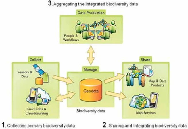
In respect to our current research, GIS can be utilized as an advanced cloud computing technology to develop a web server application to distribute species distribution maps, share biodiversity databases and delivering biodiversity information services to improve internal workflows, communicate vital issues and engage stakeholders in Asian region. An illustration of a GIS web server managed by using a geodata for utilizing biodiversity information is shown in Fig.1.
A framework for databases and system integration
An advanced research has been performed to create and design geodata integration which makes full use of the capabilities of a GIS web application and a server. Fig. 2 shows designing framework to
DJAMALUDDIN et al.: GIS web server for biodiversity information system
2015] 251
Fig. 2. Framework of designing biodiversity integration databases and services system
integrate biodiversity databases and biodiversity related geospatial databases for enabling the comprehensive searching, acquisition, development and utilization of biodiversity information services. In this framework, the geodata for biodiversity information are not just another spatial data format that can be used; it is an integral part of the GIS web server system. Biodiversity datasets from research groups and public organizations will be collected to develop datasets, data modeling and geodata by utilizing GIS workflow process and interoperability functions. By storing biodiversity datasets from many database resources, geospatial relationships will be modeled between observation researches data (feature datasets), enabling more advanced analysis to contribute a useful component for ecological forecasting.
Development of GIS Web Application of Client Side
Nowadays, it is ordinary to observe maps or other geographic information integrated seamlessly into Web sites (Peterson, 2005). A GIS-based server can be used to share the GIS resources across an enterprise and across the GIS web resources are the maps, globes, address locators, geodata and tools. The main advantages of sharing GIS resources on a GIS server are the same as sharing any data through any kind of server technology (Goodchild, 1993).
Components of the GIS Server System
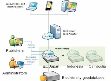
Demands are rising for easy-to-use biodiversity information that is geared toward the diverse and intensive needs of users. Fig. 2 shows the framework of designing biodiversity integration databases and services system. The following components comprise a GIS base server system site that exposes the scalability and functionality (ESRI, 2007) (Fig. 3).
1. GIS server, the GIS server does the work of fulfilling requests to web services. It draws biodiversity maps, runs tools, queries species data and performs any other action with a biodiversity information service. The GIS server can consist of one machine or many machines working together.
2. Web adaptor, is to integrate GIS servers with existing enterprise web server. The Web adaptor receives web service requests through a common URL and sends them to the various GIS server-machines in a site.
3. Web server, a web server can host biodiversity web applications and provide optional security and load balancing benefits to GIS server site. 4. Data server, biodiversity databases as a geodata
can be stored directly on each GIS server, or access it from a central biodiversity database repository.
METHODS
Development of a GIS web application for utilizing biodiversity information services
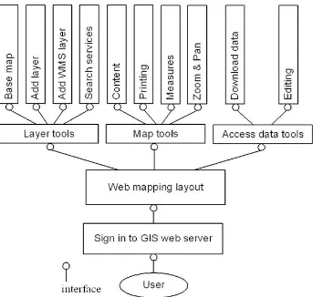
At present, our research is developing a GIS web application using Silverlight technology to investigate the capability and functionality of a GIS web application for utilizing biodiversity information services for client-side. Once biodiversity data resource has been created, it can be published rapidly as a biodiversity information service and it can be shared by a GIS web application. The interface of the web application created by Silverlight technology that mainly uses to increase the quality and convenience by, for example, providing easy access to a high level of useful biodiversity information services, ecological analysis tools and other biodiversity related geospatial information services. Fig. 4 shows the tool interface functions of the developed GIS web application in which user can access the services for
searching and utilization of biodiversity information. Fig. 5 shows the interface of the developed GIS web application using Silverlight technology and interface of tools to provide easy access of biodiversity information. Detail explanation of the tool functions are described as follows.
1. Layer tools (scalability)
Layer tools are established to provide the user-side for integrating other biodiversity information services or base map which is provided by the developed GIS server or other available server. The operation tool is set according to the content of the operation such as Add Layer is used to add data to the biodiversity distribution map by browsing to an GIS server endpoint, and Add web map services (WMS) layer is used to add OGC (open geospatial consortium) web map services. The Base map and Search services are provided as a common tool to add a base map and online map services.
2. Map tools (functionality)
Map tools are basic function for the map and the data that makes the users uses it in the exploration of biodiversity information. The map function tools of the content, the printing, the measure and the zoom & pan is provided as a user function to the comprehensive searching, acquisition. A content function is included in the map tools to give biodiversity information about the data services, and layers.
3. Access data tools (accessibility & inter-operability)
DJAMALUDDIN et al.: GIS web server for biodiversity information system
2015] 253
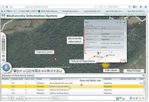
Fig. 5. Interface of the developed GIS web application layout and tools for biodiversity information system
Select base
Add layers
Search Geodata services
Table contents
Attribute tables
Query database layers
Spatial analysis (an example)
Download, measure & print
Add Open Layer (WMS) services
DJAMALUDDIN et al.: GIS web server for biodiversity information system
2015] 255
Fig. 8. Four examples of power point slides in a draft Pictured Guide.
Fig. 9b. Basemap provides geographical context and background for the content in a map.
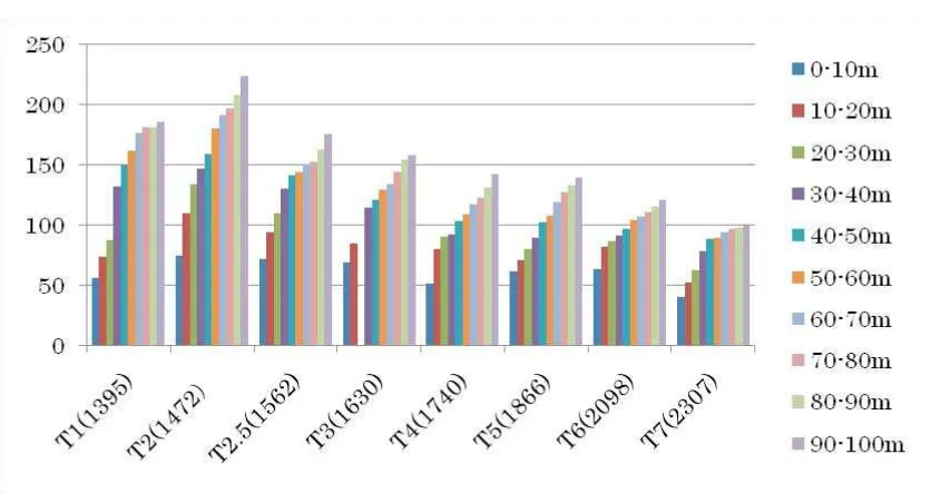
Fig. 10. Species richness in eight transects. Bars show cumulative numbers of species in ten sections of the transects.
(access feature and data update, etc.) are prepared, and web browser can be used properly according to user roles and the authority. Accessible biodi-versity datasets and the function are limited by the user account at login.
RESULTS AND DISCUSSION
Biodiversity data sharing using a GIS web ap-plication (a case study)
A botanical survey at Mt. Gede-Pangrango, West Java, Indonesia was conducted from
DJAMALUDDIN et al.: GIS web server for biodiversity information system
2015] 257
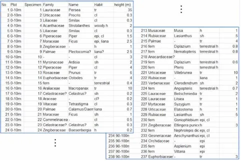
transect to ten sections of 10 m × 4 m (see Fig. 6 as an example) and recorded all the vascular plant species in the first section. From the second to tenth section, we recorded vascular plant species that we found for the first time in that transect and did not record species occurrence at the section for species that were already recorded in previous sections. We made 1705 records of species occurrence and made 1099 voucher specimens to identify species. For most specimens, we took pictures in the field to edit a pictured guide for the flora of Mt. Gede-Pangrango. For epiphytes, we collected species occurring below 8 m height using a pole with a cutter on the top. Thus, some species growing on tree trunks or branches higher than 8 m may be unrecorded. Fig. 7 shows a part of data recorded in transect 1 as an example of raw data structure. In addition to these species occurrence records, we recorded the approximate height of trees higher than 3 m in each section to the nearest 1 m for trees lower than 10 m and to the nearest 5 m for trees higher than 10 m. We used a pole of 8 m as a reference. This data provides the number of trees belonged to a height class in each section.
Identification
We tried to identify as many species as possible in the field using taxonomic literature at hand including the Flora Taman National of Mt. Gede-Pangrango (Sunarno & Rugayah, 1992) in which 844 taxa are listed with a short description. After the field survey, we identified species of Urticaceae, Ficus, Lasianthus and some other plant groups. However, most specimens remain to be identified or their identifications remain to be verified. Thus, the results described below are based on tentative identifications that should be revised by further studies with specimens.
Pictured guide
We prepared a pictured guide of the plants we collected by editing pictures that we took for 1099 specimens in the field using the software Power Point (Fig. 8). This power point files will be used to give the detail information about the species.
Biodiversity information services
For preliminary assessment of the effectiveness of the developed GIS web server application, plant survey datasets of the Mt. Gede-Pangrango (Microsoft Excel spreadsheet, raster image, power point files, Geo-reference data, etc.) was used to create, integrate and utilize biodiversity information as Geodata. Using a Geodata, a GIS web server can be used to collect primary biodiversity data, share and integrate biodiversity data and aggregate the integrated biodiversity data from many sources of data. Fig. 9a shows the
interface of the GIS web application that contains the biodiversity information services of the Mt. Gede-Pangrango. Moreover, the interface of the GIS web application shows the biodiversity data-base on spreadsheet, picture of specimens and photos. With this application, users can add, edit and manage biodiversity data and ready to use basemaps (topography, geology, vegetation cover, etc.) through internet access. A basemap provides geographical context and background for the content that want to display in a map (Fig. 9b). The GIS web server application for Silverlight provides with several basemaps from which to choose suitable backgrounds for geospatial data of the Mt. Gede-Pangrango in which other technology platforms (e.g. MapServer, or GeoServer) do not provided.
Charting species richness using biodiversity information services
By using the distribution of topography data from biodiversity information services, species richness was the highest in T2 at 1270 m and the lowest in T7 at 2300 m. Species richness continuously decreased with altitude in 8 transects placed along the trail to theMt. Gede-Pangrango (Fig. 10). Species richness of T1 at the lowest elevation (in the reserve of Cibodas Botanical Garden) was the second highest. Cumulative numbers of species showed saturating trends in T1 and T7, but increased nearly proportionally in other transects.
CONCLUSIONS
In this paper, a GIS web server for biodiversity information system that is a synthesis of individual systems and services has been developed. Moreover, a GIS web application using Silverlight technology has been established for client-side that enabling the comprehensive searching and utilization of biodiversity information. To demonstrate the effectiveness of the GIS web server application, plant biodiversity survey at the Mt. Gede-Pangrango, West Java in Indonesia, as one of important ecological protection areas has been studied for utilizing biodiversity information services. With the developed GIS web server, users can query the survey data of each species, view the location and photo of the species, and find the data of each species, etc.
internet-based biodiversity information services that support cooperation among public research organizations, university researchers, community residents, NPOs and others. Using a GIS web application makes sharing biodiversity database about important biodiversity information services and ecological conservation decisions more efficient and effective.
ACKNOWLEDGEMENTS
This work was supported in part by Global COE Program (Center of excellence for Asian conservation ecology as a basis of human-nature mutualism), MEXT, Japan. We thank RISTEK for issuing the na-tional research permits and the Research Centre for Biology-LIPI in their field research and provided facili-ties for laboratory analysis.
REFERENCES
BATTRICK, B. 2006. The Changing Earth, ESA Pub-lication Division, The Netherlands. Ecosystem to Global Scales. Taylor & Francis, London. Pp. 299– 314.
ESRI (Environmental Systems Research Institute), Geo-spatial Service-Oriented Architecture (SOA), an ESRI White Paper. Retrieved June 2007 from: http://www.esri.com/library/whitepapers/pdfs/ geospatial-soa.pdf.
GOODCHILD, M. F. 1993. Sharing Imperfect Data, Sharing Geographic Information. New Brunswick, New Jersey. Pp. 363– 374.
JOHN, J. K. & DONALD, L. P. 1994. Global Envi-ronmental Characterization: Lessons from the NO-AA-EPA Global Ecosystems Database Project. Environmental Information Management and Analy-sis: Ecosystem to Global Scales. Tailor & Francis, London. Pp. 315– 327.
LETCHER, T. 2009. Climate Change, Observed Im-pacts on Planet Earth. Elsevier, The Netherlands. PETERSON, M. P. 2005. Maps and the Internet.
Else-vier, The Netherlands.
POLLOCK, R. J. & MCLAUGHLIN, J. D. 1991. Data-based management system technology and geo-graphic information systems. J. of Surveying Engi-neering 117 (1): 9 – 26.
SUNARNO, B. & RUGAYAH. 1992. Flora Taman Nasional Gede Pangrango. Herbarium Bogoriense, Puslitbang Biologi – LIPI, Bogor.
INSTRUCTION TO AUTHORS
Scope. R einwardtia is a scientific ir r egular jour nal on plant taxonomy, plant ecology and ethnobotany
published in December. Manuscript intended for a publication should be written in English.
Titles. Titles should be br ief, infor mative and followed by author’s name and mailing address in
one-paragraphed.
Abstract. English abstr act followed by Indonesian abstr act of not mor e than 250 wor ds. Keywor ds
should be given below each abstract.
Manuscript. Manuscr ipt is or iginal paper and r epr esent an ar ticle which has not been published in any
other journal or proceedings. The manuscript of no more than 36 pages by using Times New Roman 11, MS Word for Windows of A4 with double spacing, submitted to the editor through <[email protected]>. New paragraph should be indented in by 5 characters. For the style of presentation, authors should follow the latest issue of Reinwardtia very closely. Author(s) should send the preferred running title of the article submitted. Every manuscript will be sent to two blind reviewers.
Identification key. Taxonomic identification key should be pr epar ed using the aligned couplet type.
Nomenclature. Str ict adher ence to the Inter national Code of Botanical Nomenclatur e is obser ved, so
that taxonomic and nomenclatural novelties should be clearly shown. English description for new taxon proposed should be provided and the herbaria where the type specimens area deposited should be presented. Name of taxon in taxonomic treatment should be presented in the long form that is name of taxon, author’s name, year of publication, abbreviated journal or book title, volume, number and page.
Map/line drawing illustration/photograph. Map, line dr awing illustr ation, or photogr aph pr efer ably
should be prepared in landscape presentation to occupy two columns. Illustration must be submitted as original art accompanying, but separated from the manuscript. The illustration should be saved in JPG or GIF format at least 350 pixels. Legends or illustration must be submitted separately at the end of the manuscript.
References. Bibliogr aphy, list of liter atur e cited or r efer ences follow the Har var d system as the
following examples.
Journal : KRAENZLIN, F. 1913. Cyrtandraceae novae Philippinenses I. Philipp. J. Sci. 8: 163–179.
MAYER, V., MOLLER, M., PERRET, M. & WEBER, A. 2003. Phylogenetic position and generic differentiation of Epithemateae (Gesneriaceae) inferred from plastid DNA sequence data. American J. Bot. 90: 321–329.
Proceedings :TEMU, S. T. 1995. Peranan tumbuhan dan ternak dalam upacara adat “Djoka Dju” pada suku Lio, Ende, Flores, Nusa Tenggara Timur. In: NASUTION, E. (Ed.). Prosiding Seminar dan Lokakarya Nasional Etnobotani II. LIPI & Perpustakaan Nasional: 263–268. (In Indonesian).
SIMBOLON, H. & MIRMANTO, E. 2000. Checklist of plant species in the peat swamp forests of Central Kalimantan, Indonesia. In: IWAKUMA, T. et al. (Eds.) Proceedings of the International Symposium on: Tropical Peatlands. Pp.179-190.
Book : RIDLEY, H. N. 1923. Flora of the Malay Peninsula 2. L. Reeve & Co. Ltd, London.
Part of Book : BENTHAM, G. 1876. Gesneriaceae. In: BENTHAM, G. & HOOKER, J. D. Genera plantarum 2. Lovell Reeve & Co., London. Pp. 990–1025.
Thesis : BAIRD, L. 2002. A Grammar of Kéo: An Austronesian language of East Nusantara. Australian National University, Canberra. [PhD. Thesis].
Website : http://www.nationaalherbarium.nl/fmcollectors/k/KostermansAJGH.htm). Accessed 15 February 2012.
REINWARDTIA
Author Agreement Form
Title of article :
Name of Author(s) :
I/We hereby declare that:
My/Our manuscript was based on my/our original work.
It was not published or submitted to other journal for publication.
I/we agree to publish my/our manuscript and the copyright of this article is owned by Reinwardtia. We have obtained written permission from copyright owners for any excerpts from copyrighted
works that are included and have credited the sources in our article.
Author signature (s) Date
___________________________________________________________________________________________
Name
Published by Herbarium Bogoriense, Botany Division, Research Center for Biology, Indonesian Institute of Sciences
Address: Jln. Raya Jakarta-Bogor Km. 46 Cibinong 16911, P.O. Box 25 Cibinong Telp. (+ 62) 21 8765066; Fax (+62) 21 8765062