STUDI KERENTANAN LONGSOR PADA RUAS JALAN
DEPOSISI INTRUSI BATUAN BEKU INTERAKSI STRUKTUR SESAR
Agustinus T1, Lawalenna Samang2, Herman Parung3, and Tri Hariyanto4
ABSTRAK
Peristiwa tanah longsor pada ruas jalan didaerah Parangloe menuju ke kota Malino yang sering terjadi pada waktu musim hujan dengan curah hujan yang cukup tinggi sudah perlu menjadi perhatian untuk diteliti terutama dibeberapa titik dari khususnya dari Km +62 kearah kota Malino yang terletak di kecamatan Parangloe. Tujuan dari penelitian ini dapat ditinjau dari pengaruh kontrol topografi yang memiliki variasi dan kondisi geologi yang tersusun oleh tubuh tanah atau batuan residual vulkanik berumur Pliosen-Miosen, berasal dari hasil aktivitas vulkanik terdiri dari tanah dan batuan tufa, breksi, tufa berlapis, batuan beku serta keterkaitannya dengan adanya tubuh intrusi batuan beku dan struktur sesar. Ditunjang dengan metodologi startigrafi terukur, pemboran dan hasil dari pengamatan laboratorium yang terdiri dari petrografi, diharapkan dari penelitian ini dapat menjelaskan bahwa longsor yang terjadi di daerah Parangloe ada hubungan korelasi Interaksi sesar dan intursi batuan beku terhadap tubuh tanah atau batuan vulkanik.
Kata Kunci : Longsor, Tanah dan Batuan Vulkanik, Intrusi, Sesar, Parangloe.
1 1 Post Graduate Student of Civil Engineering Department, Hasanuddin University of Makassar Perintis Kemerdekaan Street
Km-10, Indonesia, Email: [email protected]
2 2 Lecturer of Physics Department, Hasanuddin University of Makassar Perintis Kemerdekaan Street Km-10, Indonesia, Email:
3 3 Lecturer of Engineering Geology Department, Hasanuddin University of Makassar Perintis Kemerdekaan Street Km- 10 ,
Indonesia,, Email: [email protected]
Terbentuk dari akumulasi micro lempeng yang terurai dari berbagai variasi sumber fragmen dari lempeng Asia,Pasific dan Australia (gambar 1). Sejak itu Formasi yang terbentuk merupakan kompleks geologi
Since its formation in the Tertiary period to the present, it
consequently produces continuous complex geological and tectonic phenomena. Due to the insistence of influence / pressure by the three major plates, it becomes a very vulnerable condition and includes one of the most active islands in the world.
Fenomena Geologi dan tektonik daerah yang tersusun oleh Parangloe Vulkanik yang terdiri dari oleh Tufa tidak berlapis dan tufa berlapis breksi, intrusi batuan beku, geological structures (joint and fault), and periodic activeness in every 15 to 30 years. Geological condition and tectonic uplift, causing shoreline changes advancing towards the sea, the occurrence of abrasion, sedimentation and uplift, threatened marine biota (benthos), shallower seabottom in the front of port of Parepare, bedrock
earthquake at any time, will lead to vulnerable coastal area. Further studies are needed to support an integrated management of the coastal area.
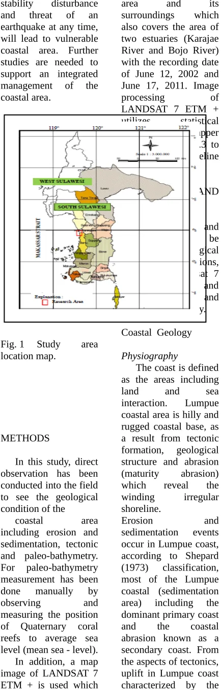
Fig. 1 Study area location map.
METHODS
In this study, direct observation has been conducted into the field to see the geological condition of the
coastal area
including erosion and sedimentation, tectonic and paleo-bathymetry. For paleo-bathymetry measurement has been done manually by
observing and
measuring the position of Quaternary coral reefs to average sea level (mean sea - level). In addition, a map image of LANDSAT 7 ETM + is used which includes Lumpue coast
also covers the area of two estuaries (Karajae River and Bojo River) with the recording date of June 12, 2002 and June 17, 2011. Image
processing of
LANDSAT 7 ETM + utilizes statistical software ERMapper 7.0 and ArcGIS 9.3 to digitize shoreline change map.
RESULTS AND
DISCUSSIONS
Results and
discussions will be based on geological coastal conditions, analysis by Landsat 7 ETM +, tectonic and paleo-bathymetry and coastal vulnerability.
Coastal Geology
Physiography
The coast is defined as the areas including
land and sea
interaction. Lumpue coastal area is hilly and rugged coastal base, as a result from tectonic formation, geological structure and abrasion (maturity abrasion) which reveal the winding irregular shoreline.
Erosion and
sedimentation events occur in Lumpue coast, according to Shepard (1973) classification, most of the Lumpue coastal (sedimentation area) including the dominant primary coast and the coastal abrasion known as a secondary coast. From the aspects of tectonics, uplift in Lumpue coast characterized by the coastal terrace and
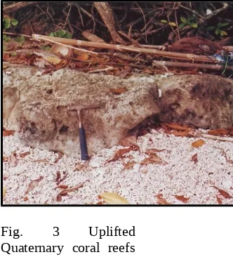
Quaternary alluvial flat, including emergence coast, Johnson, 1919 (Fig. 2 and Fig. 3).
Lithology
The rocks found in
Lumpue coast
(Sukamto, 1982)
consists of lava, volcanic breccia, tuff
(Upper Miocene),
Quaternary sandstones and alluvial
deposits. Lava, volcanic breccia and tuff are trachytic sourced from the eruption of Parepare volcano
(Kaharuddin, 2007) with Lumpue coastal caldera, alluvial and
sandstones are
Quaternary sediments from the terrestrial erosion processes. METHODS
In this study, direct observation has been conducted into the field to see the geological condition of the
coastal area
including erosion and sedimentation, tectonic and paleo-bathymetry. For paleo-bathymetry measurement has been done manually by
observing and
Tectonics and Paleo-bathymetry
In addition, a map image of LANDSAT 7 ETM + is used which includes Lumpue coast
area and its
surroundings which also covers the area of two estuaries (Karajae River and Bojo River) with the recording date of June 12, 2002 and June 17, 2011. Image
processing of
LANDSAT 7 ETM + utilizes statistical software ERMapper 7.0 and ArcGIS 9.3 to digitize shoreline change map.
RESULTS AND
DISCUSSIONS
Results and
discussions will be based on geological coastal conditions, analysis by Landsat 7 ETM +, tectonic and paleo-bathymetry and coastal vulnerability.
Coastal Geology
Physiography
The coast is defined as the areas including
land and sea
interaction. Lumpue coastal area is hilly and rugged coastal base, as a result from tectonic formation, geological structure and abrasion (maturity abrasion) which reveal the winding irregular shoreline.
Erosion and
sedimentation events occur in Lumpue coast, according to Shepard (1973) classification, most of the Lumpue coastal (sedimentation area) including the dominant primary coast and the coastal abrasion known as a secondary coast. From
the aspects of tectonics, uplift in Lumpue coast characterized by the coastal terrace and uncovering Quaternary coral reefs and also Quaternary alluvial flat, including emergence coast, Johnson, 1919 (Fig. 2 and Fig. 3).
Lithology
The rocks found in
Lumpue coast
(Sukamto, 1982)
consists of lava, volcanic breccia, tuff
(Upper Miocene),
Quaternary sandstones and alluvial
deposits. Lava, volcanic breccia and tuff are trachytic sourced from the eruption of Parepare volcano
(Kaharuddin, 2007) with Lumpue coastal caldera, alluvial and
sandstones are
Quaternary sediments from the terrestrial erosion processes.
RESULTS AND
DISCUSSIONS
Results and
discussions will be based on geological coastal conditions, analysis by Landsat 7 ETM +, tectonic and paleo-bathymetry and coastal vulnerability.
Fig. 2 Coastal terrace (X) and abrasion flat (Y), the caldera cliff on the Lumpue coast.
Fig. 3 Uplifted Quaternary coral reefs above sea level in the Dutungan area.
X
Geological structure
Geological
structures that appear in the Lumpue coast area are join and fault. The join in the form of open and closed irregular joint, while the fault through Bojo River and the east-west trending and in Karajae River in the north, both are dextral slip fault.
.
Abrasion and
sedimentation
Apparent abrasion on trachytic lava can be seen either at Lumpue coastal area or at Ujung Lero peninsula. The nature of acid rock is not resistant to sea water waves (alkaline), consequently causing an increased the rate of abrasion, especially during the west season, from January to April every year. Sediments from Karajae River and Bojo River are
apparently lying along Lumpue Coastal area consist of sand and gravel particularly from stream sediment and several other small rivers (Fig. 4).
Fig. 4 Sand deposit at Lumpue coast.
Landsat 7 ETM + Analysis
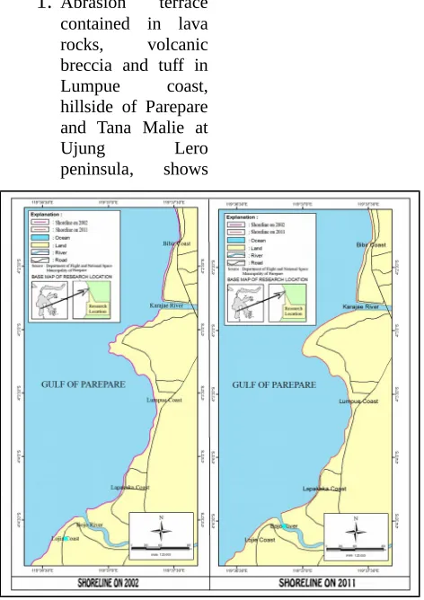
Interpretation of shoreline changes based on Landsat 7 ETM + from year of 2002 and 2011 are combined with field data, indicating that the shoreline change is dominated by the rapid advancement of the shoreline seaward along the 6-13 meters, covering southern part of Lumpue coastal area (the Lojie coast,
Lapakaka coast),
Karajae estuary and its surrounding. Changes of coastal area are causing by: (1) sedimentation is about 36491.24 m2; (2) abrasion is about 40458.95 m2; and (3) reclamation is about 61847.24 m2. Based on the calculation above, the natural process of abrasion is more extensive (bigger) than the area of deposition. In reality, there is an advance of the
shoreline. This shows that the sedimentation rate (man made and natural processes) is greater than the mass of sediment removal, so even if the abrasion occurs, the re-sedimentation process still takes place in the Lumpue coastal area. It is clear that the
shoreline grows
seaward (Fig. 5).
Fig. 5 Shoreline change map of Lumpue coast.
Tectonics and Paleo-bathymetry
The development of Sulawesi regional tectonic affected by divergent tectonic activity of the Pacific plate moves westward, urged the island of Sulawesi, produce large
fault trending
southeast–northwest known as Walanae Fault accompanied by small fault, rocks deformation, up-lift of the coastal base and coral reefs as well as abrasion rate increasing (Kaharuddin, 2007).
The Phenomena of Quaternary tectonics
Quaternary tectonic phenomena that appear in the coastal areas surrounding Lumpue such as abrasion terrace, coast terrace (sand), alluvial flat, rocks jointing, lifting of coral reefs and the earthquake. The details can be mentioned as follows:
1.
Abrasion terrace contained in lava rocks, volcanic breccia and tuff inLumpue coast,
hillside of Parepare and Tana Malie at
Ujung Lero
peninsula, shows
cliff and abrasion flat (Figure-2). The forming of the abrasion terrace as a result of vertical up-lift of a vertical of at least 5 times as much (of a number of terrace exposed);
2.
There are Lumpue coast terrace which composed by the steps of sandsediment that
extends parallel to the shoreline;
3.
Alluvial flatoccupies Lumpue plain and Parepare city;
4.
Joints on rock, cracks in rocks that are not regular and high density as the impact of rock deformation and two faults through this area;5.
Uplift of coral reef. Regionally, the west coast of Sulawesi, including Lumpue coast, coral reefs are emerging in the form of islands above the sea level around 0.5 to 4 meters (Figure-3);6.
Earthquake in Parepare (Lumpue)is an active seismic lines of Walanae-Majene having a return period of between 15 to 30 years (Kaharuddin, 2007).
Paleo-bathymetry
Manually Paleo-bathymetry
measurement aimed to determine the presence of tectonic uplift and sea-level change which impacts the shoreline
changes. This
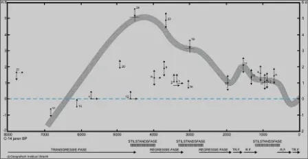
measurement is done by observing and measuring the position of the Quaternary reef on mean sea level. This method is based on the assumption that coral reefs flourish at a depth of at least 5 meters below sea level. A long the Lumpue coast and Dutungan coast at the south, there are reefs outcrop up to ± 50 cm above sea level now. According to De Klerk (1982), any increase in the base 1 meter reef takes 1000 years. Accordingly, the age of the coastal basement is now exposed in the form of land about 5500 years which was once a shallow sea with a depth of ± 5.5 to 6 meters. De Klerk has conducted research on the coral reefs of the C14 dating and changes in sea level due to tectonic uplift. It shows that from 7000-4500 years ago there was an increase in sea level of about 5 meters, and up to 1500 years ago there was a decrease in sea level due to the uplift sea basement (Fig. 6).
the Quaternary era ( De Klerk , 1982) .
Coastal Vulnerability Based on Tectonics and Shoreline Change
Tectonic activity in the form of rock layers up-lift can make intensive more erosion processes on the earth's surface. The results of optimally eroded rocks and coastal sediment material. If sediment supply is smaller than the wave energy, there will be abrasion
causing landward
retreat of the shoreline, as was the case in most
Lumpue coastal. shown in igneous lava and volcanic breccia
that experienced
intensive abrasion (Fig. 7).
Fig. 7 High abrasion of lava and volcanic
a. Up-lift of basement
coastal and
sediment accumulation, causing threat to the port of Parepare and benthic
organisms; b. Abrasion
activities more intensified work in line with the increased of wave activity, result due to up-lift;
c. Geological structure zone is mainly the fault and joint are vulnnerable to physical
changes, rock resistance weakened, vulnerable to earthquakes and mass
movement;
d. Unconsolidated sediment of coastal lithology and less massive are vulnerable to abrasion, soil mechanics aspects (bearing capacity) as well as every time happen
earthquake at Parepare city; It is supported by the evidence discovered by Kaharuddin
compared with the effects of abrasion. This resulted in the
sorting and
distribution of sedimentary material less than perfect so that low bearing capacity.
CONCLUSIONS AND RECOMMENDATION S
1. Conclusions
a. Geology Conditions of Lumpue coast has hilly morphology, plains and irregular shoreline - including a primary coastal type
and emergence,
composed of lava, volcanic breccias, tuffs and alluvial. It affected
by the fault structure, joint and abrasion.
b. Analysis of Landsat 7 ETM+ images showed abrasion wider area (40458.95 m2) than the sedimentation area (36491.24 m2), but that is accompanied by re-sedimentation so shoreline changes along the sea advancing toward 6-13 meters during 2002-exposure terrace coastal, alluvial flat, jointing rock,
lifting of
Quaternary coral
reefs and
earthquake;
-
Paleo-bathymetry, shows coastal basement condition exposed by tectonic uplift about 5.5 to 6 meters above sea level for ± 5,500 years ago (BP);
-
The coastal vulnerability such as uplift and decreasing depththe Parepare
harbor also benthic organism, the abrasion activity more intensive, rock fracture and high weathering, unconsolidated sediment,
vulnerable to
abrasion and
bearing capacity, analysis of Landsat 7 ETM+ images shows that erosion and sedimentation interaction
Tectonics and Paleo-bathymetry
2. Recommendations
Further research is needed to support an integrated management of the coast.
REFERENCES
Addo, K.A., (2009), Detection of coastal erosion hotspots in Accra, Ghana,
Journal of
Sustainable Development in Africa. 11(4). De Klerk, L.G.,
(1982), Sea-level, reef and coastal plains of South West Sulawesi, Indonesia,
Ultrech, Netherland. Kaharuddin, (2007),
The impact of quatenary tectonic to sea-level and climate global
change in
Indonesia, case study in Dutungan Island, Barru Regency,
Engineering Faculty Research Result Proceeding. 1.
Kaharuddin, (2013), Study of volcano facies and the implication for metal minerals resource potential at central facies of Pangkajene Caldera,
Sidenreng Rappang
Regency. South Sulawesi
Province,
Engineering Faculty Research Result Journal, Engineering
Makassar coastal area based on mitigation of natural hazard (case Study in Barombong Coast
– Celebes
convention centre) Research Result Proceeding, Engneering Faculty. 5.
Kumar, A., Kunte, P.D., (2012), Coastal vulnerability assessment for Chennai, East Coast of India using geospatial technique, Natural Hazard.. 6 : 853-872.
Mukhopadhyay, A., Dasgupta, R.,
Geology, Earth and
Environmental Sciences. 2(1) : 57 – 69. shoreline change : An indicator of coastal vulnerability for Huan
landuse and
Development in Kien Giang, Vietnam.
Pendleton, E,A.,
Thieler, E.R., Williams, S.J., (2010), Importance of coastal change Coastal Research. 26 (1) : 176 – 183.
Reyes, S.R.C., Blanco, A.C.,(2012), Assessment of coastal vulnerability to sea level rise of Bolinao Pangasinan using remote sensing and geographic information system, International Archieve of the Photogrammetry, Remote Sensing
and Spatial
Information Sciences. 6. Rustamadji, R.M.,
Danial, M., Priadi, E., and Zulkarnaen (2010),
Vulnerability model of coastal area : case study at
South Jawai
Distric and Jawai Distric Sambas West Kalimantan,
Journal of Disaster Preventing Shoreline changes and its influence for level of coastal vulnerability, Proceedings of
International Conference on Georesources and Geological Faculty, Gadjah Mada University. : 289 – 298.
Sukamto, R., (1982), The Geology of the Pangkajene and Western Part Centre, Bandung. Tarigan, M.S., (2007),
The shoreline
change at
Cisadane coastal
area, Banten