SUSTAINABLE FISHERIES
MANAGEMENT PROJECT (SFMP)
EXCHANGE VISIT FOR TCPD
OFFICERS: WORKSHOP REPORT
This publication is available electronically on the Coastal Resources Center’s website at http://www.crc.uri.edu/projects_page/ghanasfmp/ and Hen Mpoano’s website at
http://www.henmpoano.org
For more information on the Ghana Sustainable Fisheries Management Project, contact:
USAID/Ghana Sustainable Fisheries Management Project Coastal Resources Center
Graduate School of Oceanography University of Rhode Island
220 South Ferry Rd.
Narragansett, RI 02882 USA
Tel: 401-874-6224 Fax: 401-874-6920 Email: [email protected]
Citation: Mensah, J., Amoakoh, A.O., Kankam, S. (2015). Exchange Visit for TCPD Officers: Workshop Report, June 29 – 30, 2015. The USAID/Ghana Sustainable Fisheries Management Project (SFMP). Narragansett, RI: Coastal Resources Center, Graduate School of Oceanography, University of Rhode Island, Hen Mpoano and Spatial Solutions.
GH2014_SI013_HM. 22 pp. Authority/Disclaimer:
Prepared for USAID/Ghana under Cooperative Agreement (AID-641-A-15-00001) awarded on October 22, 2014 to the University of Rhode Island and entitled; the USAID/Ghana Sustainable Fisheries Management Project (SFMP).
This document is made possible by the support of the American People through the United States Agency for International Development (USAID). The views expressed and opinions contained in this report are those of the SFMP team and are not intended as statements of policy of either USAID or the cooperating organizations. As such, the contents of this report are the sole responsibility of the SFMP Project team and do not necessarily reflect the views of USAID or the United States Government.
Cover photo: Workshop in session
Detailed Partner Contact Information:
USAID/Ghana Sustainable Fisheries Management Project (SFMP) 10 Obodai St., Mempeasem, East Legon, Accra, Ghana
Brian Crawford Chief of Party [email protected]
Najih Lazar Senior Fisheries Advisor [email protected]
Patricia Mensah Communications Officer [email protected]
Bakari Nyari Monitoring and Evaluation Specialist [email protected]
Don Robadue, Jr. Program Manager, CRC [email protected]
Justice Odoi USAID Administrative Officer Representative [email protected]
Kofi.Agbogah
SNV Netherlands Development Oganization #161, 10 Maseru Road,
E. Legon, Accra, Ghana 233 30 701 2440
Donkris Mevuta Kyei Yamoah
[email protected] Friends of the Nation Parks and Gardens Adiembra-Sekondi, Ghana 233 312 046 180
Peter Owusu Donkor Spatial Solutions
[email protected] #3 Third Nautical Close,
Nungua, Accra, Ghana
Darkuman Junction, Kaneshie Odokor Highway
Headmaster residence, Sekondi College Sekondi, Western Region, Ghana 233 243 326 178
For additional information on partner activities: CRC/URI: http://www.crc.uri.edu
ACRONYMS
CEDECOM Central Region Development Commission
CR Central Region
CRC Coastal Resources Center at the Graduate School of Oceanography, University of Rhode Island
CSLP Coastal Sustainable Livelihood Project EDC Environmental Data Center
EPA Environmental Protection Agency GHA Ghana Highways Authority
GIS Geographic Information System
GIZ German Federal Enterprise for International Cooperation GoG Government of Ghana
GPS Global Positioning System GSS Ghana Statistical Service
GUMPP Ghana Urban Management Pilot Programme ICFG Integrated Coastal and Fisheries Governance IUU Illegal Unreported Unregulated
LAP Land Administration Project
LUPMIS Land Use Planning and Management Information System MMDAs Metropolitan Municipal and District Assemblies
MOFAD Ministry of Fisheries and Aquaculture Development RIGIS Rhode Island Geographic Information System SDF Spatial Development Framework
SFMP Sustainable Fisheries Management Program SNPA Street Naming and Property Addressing TCPD Town and Country Planning Department
UN United Nations
URI University of Rhode Island USA United States of America
USAID United States Agency for International Development VRA Volta River Authority
Table of Contents
Acronyms ... iii
Introduction ... iv
Chairperson’s Remarks ...1
Summary of Presentations ...2
Overview of SFMP and Purpose of the Exchange Visit ...2
General Status of planning in the Central Region ...5
Leveraging the Power of GIS for Informed Community Planning ...8
Experiences from the Western Regional Data Hub ...9
Breakout Session:...12
Field Visit...15
Feedback from Participants...16
Next Steps ...16
Annex ...17
LIST OF FIGURES
Figure 1: The Chairperson of the workshop delivering his welcome remarks ... Error! Bookmark not defined. Figure 2: Participants listening to presentation on the purpose of the project and the workshop. ...3Figure 3: From left to right: Richard Jones, Kobena Asiedu Bediako and Eugene Nyansafo responding to questions from participants ...10
Figure 4: Participants during the breakout session ...13
INTRODUCTION
The Ghanaian fishery is on the verge of collapse. More than 100,000 metric tons of high quality low-cost animal protein that was traditionally available to poor and vulnerable coastal and inland households has been lost. Overfishing due to an increasing number of boats and fishers in an open access fishery and weak governance all contribute to this situation.
At risk are not only the livelihoods of more than 25,000 Ghanaians engaged in the fishery sector but also the food security of the nation. In addition to the crisis in the fishery, coastal communities are vulnerable to hazards and evolving impacts of climate change, particularly sea level rise, flooding, less frequent rainfall as well as non-climate stressors including mangrove degradation, poor land use, landlessness, poverty etc.
The Sustainable Fisheries Management Project (SFMP) is a five-year initiative supported by the U.S. Agency for International Development (USAID-Ghana) whose main goal is to rebuild targeted marine fisheries stocks through the adoption of sustainable fishing practices and exploitation levels
The SFMP will work closely with the Government of Ghana (GoG) through the Ministry of Fisheries and Aquaculture Development (MOFAD) under the World Bank-funded fisheries project as well as with the Fisheries Commission (FC) to achieve the goal of revamping the fisheries sector. The project will also engage with the Town and Country Planning Department (TCPD) for effective spatial planning of the coastal communities.
SFMP will build on the lessons learned and experiences gained from the engagement with TCPD under the Integrated Coastal and Fisheries Governance (ICFG) initiative in the Western region. One major outcome of this engagement is the proposed establishment of an Environmental Data hub in the Central region after the similitude of the Regional GIS Data Hub the ICFG established in the western region.
The Exchange Visit/Study tour forms part of the ongoing efforts to replicate the Data Hub idea in the Central Region. The purpose of this workshop was to initiate peer-to-peer exchange among planners from both the Western and Central regions and to demonstrate the successes and experiences from the western regional GIS data hub.
A total of 30 participants attended the two-day workshop. This comprised Spatial Planners and Technical officers from all the Coastal Metropolitan Municipal and District Assemblies (MMDAs) in the two regions; representatives from the TCPD headquarters in Accra and CEDECOM. The Western Regional Director of TCPD who is also the acting Director of Central regional office was present to grace the event. Also in attendance were selected staff of three SFMP implementing partners: Coastal Resources Center/University of Rhode Island, Hen Mpoano and Spatial Solutions.
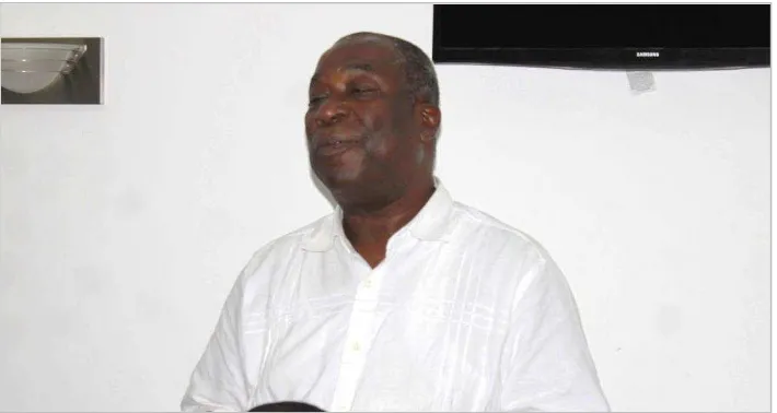
CHAIRPERSON’S REMARK
S
deliberate extensively on how spatial planning can be practical and effective. He concluded his speech with a quote by Julius Kambarage Nyerere;
“Of what use is a building if the building
is not used to educate people”
Figure 1: The Chairperson of the workshop delivering his welcome remarks. (Photo Credit: Hen Mpoano)
SUMMARY OF PRESENTATIONS
Presentations were delivered by staff of SFMP and TCPD officers. The presentations outlined the objective of the SFMP and purpose of the exchange visit, current status of planning in the central region, application of the hub facility and trainings in the western region and a similar application in Rhode Island, USA.
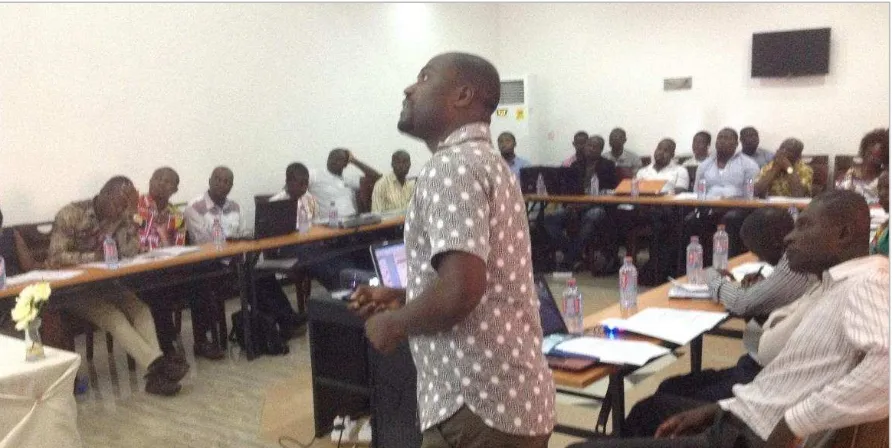
OVERVIEW OF SFMP AND PURPOSE OF THE EXCHANGE VISIT
Stephen Kankam, Activity Manager (Western and Central) for SFMP
Figure 2: Participants listening to presentation on the purpose of the project and the workshop. (Photo Credit: Hen Mpoano)
Despite its fisheries focus, Stephen explained that coastal spatial planning plays an important role of achieving this goal. He reiterated the need to address spatial planning in a fisheries management project. According to him, more than 90% of fishing activities is carried out on land. “Fisheries are water dependent hence requires proximity to land. The limited coastal land should therefore be planned in a sustainable manner to accommodate the teeming migrant population and the dynamic coastline".
It is against this background that the project is working with the Town and Country Planning Department and the MMDAs to incorporate sustainable coastal planning in their development plans. These plans should be based on data collected and processes in a systematic manner by trained expert in the department. He explained that the purpose of the Exchange visit was to assess status of GIS based planning in WR and CR and to initiate peer-to-peer relationship among planning officers from the two regions.
Selected slides
This overall goal has been broken further into four Intermediate result areas
Coastal spatial planning is a major activity under the intermediate result area IR 4
Why address spatial planning in a fisheries management project?
GENERAL STATUS OF PLANNING IN THE CENTRAL REGION
Obed Agyapong, TCPD, Gomoa East
The presentation provided the background of the Central region with emphasis on population dynamics, available resources and major economic activities. The presentation also highlighted the capacity of the TCPD at both the MMDA and regional levels. Obed concluded his presentation with a look at some challenges faced by the region and some recommendations.
Selected slides
Are you liaising with the fisheries commission on the project?
The project will work with the Government of Ghana through the Fisheries Commission and MOFAD
The consumption of tilapia in the country is high. Is the project considering aquaculture?
The focus of this project is marine fisheries and the objective is recovery of small pelagic fish stocks and not aquaculture.
How will the the project measure the sustainability of the fishery?
The M&E document for the project has
establihsed baseline ecological status and this will be compared with end of project data
There is the need for the project to consider encroachment on the coast
Are you going to develop a framework for spatial planning in the district?
The project will not formulate spatial plans but will contribute fisheries and coastal information to the process
Stakeholders are not working together. There is the need for fisheries commission, planners, etc to be brought together
Population of Coastal MMDAs Is 51.17% of total population of the region
Human resource capacity of central region TCPD
Questions and Comments
Questions and Comments Responses
Legal backing will help planners to exercise their duties effectively
There is mad rush for vast lands for real estate development in central region especially areas closer to greater accra region
Is there a local plan for the coastal communities in the central region?
LEVERAGING THE POWER OF GIS FOR INFORMED COMMUNITY
PLANNING
Christopher Damon, EDC, URI, Rhode Island
The highlight of the presentation was on the goal and the primary functions of a data hub. Chris explained the RIGIS conceptual model of the data hub and took participants through the fundamental principles of a data hub. After a brief history of the Environmental Data Center in the University of Rhode Island, Chris provided two instances where the data hub model was used for informed community planning in the state.
Selected slides
The land tenure arrangement in the central region is a bit different from most parts of the country where chiefs own the lands. Lands are owned by families in the central region, the need therefore to look at it as such and target family heads in decision making
The conceptual model of the data hub that the EDC has adopted over the years is a continuous loop of data exchange from the central hub and beneficiaries/stakeholders. The hub provides capacity building to stakeholders in exchange for their local knowledge and data which is archived, consolidated, standardized and distributed by the hub.
Questions, Comments and suggestions
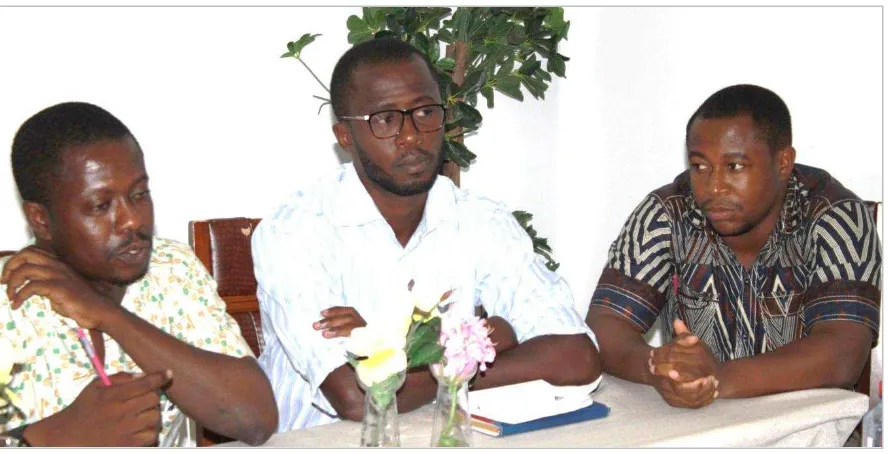
EXPERIENCES FROM THE WESTERN REGIONAL DATA HUB
Richard Jones, Eugene Nyansafo and Asiedu Bediako
The panel presentations outlined the main objective of the Western regional GIS hub and the application of the data and training in regional, district and community level planning in the region. In his presentation, Jones recounted how the inception of the GIS hub facilitated the migration from the paper maps to digital GIS maps. He also explained how the Regional hub has applied the hub conceptual model since the hub was established under the ICFG initiative
Questions and Comments Responses
How is the size of Rhode Island compared to western and central regions and how is the hub funded there?
Relatievely smaller. Rhode Island depends on project to fund the hub
How do you reduce data redunduncy? Quarterly meetings to know if communities can work together
Not charging for data
High internet
Are there any other GIS systems in RI aside the Data hub?
Figure 3: From left to right: Richard Jones, Kobena Asiedu Bediako and Eugene Nyansafo responding to questions from participants. (Photo Credit: Hen Mpoano) Eugene and Bediako also took turns to show how Shama and Ellembelle districts apply GIS in their daily planning activities. These two districts have gone through all the three levels of spatial planning
Take-home Messages:
TCPD is a service establishment of Central government, Regional Coordinating Councils, and Metropolitan Municipal and District Assemblies for the;
• Formulation of human settlement development policies.
• Formulation of legislation and technical standards to regulate the development of land.
• The preparation and coordination of plans and proposals to direct development initiated by public agencies as well as private individuals.
• Provision of various forms of planning services to other land Sector Agencies such as Lands Commission, stool lands and organizations such as the tourist board and EPA.
Some activities the hub has undertaken during the last three years of operation
include;
Staff of TCPD within the Six (6) Coastal Districts trained in LUPMIS and its applications.
• TCPD Staff within WR trained in MapMaker and basic applications of GIS
• Scanning and storage of district specific sector layouts.
• Digitizing of features via satellite images and orthophotos to guide Street Naming and Property Addressing (SNPA) implementation in selected districts.
• Hosted envoys from Uganda, Sierra Leone and students from UCC (Department of Geography)
Challenges of the hub include (but not limited to)
• Inadequate personnel needs assessment to aid training in GIS
• Limited funding resulting in limited timeframe allocated to training activities.
• Frequent power outages
• Breakdown of equipment
• Unsustainable source of funds for running the GIS Hub
Both Elembelle and Shama districts have benefited from the Hub in diverse ways and rely on the training acquired for the day-to-day planning activities albeit some challenges.
Questions and Comments
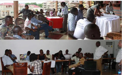
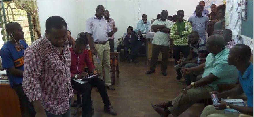
BREAKOUT SESSION:
After the presentations, participants were randomly divided into 3 groups to deliberate on possible ways to improve coastal and marine planning and decision making in the western and central regions. Using the café methodology, each of the groups discussed and shared their responses to the following questions;
a. What are the issues facing coastal places in the region?
b. What thematic data do we need to address the above mentioned issues? regional TCPD’s? What is the plan of TCPD for the hub?
How do you want to see the hub in 5years time?
Becoming a centre of excellence.
Government is passing a law to support TCPD and the hub concept.
At the moment Government support is not coming
Is there budget allocation for the hub? There isn’t. The district assemblies have the budgetary powers, not TCPD, thus making it difficult in terms of finances. However, TCPD will
soon be part of the MMDA’s under the new law expected to be passed soon, meaning there will be funds for the maintenance of the hub
TCPD should think of innovative ways of generating funds for the hub? Eg. Making agencies who access the hub pay something for the mainateinance of the hub
Going forward there can be a system where data from all the MMDAs will be submitted to feed the hub on quarterly basis
The coastal areas of Ellembelle has been earmarked for development according to the Spatial Development Framework (SDF). How do we reconcile that with fisheries protection?
Figure 4: Participants during the breakout session. (Photo Credit: Hen Mpoano)
Child trafficking
FIELD VISIT
The second day of the workshop was dedicated to field visits. The visits accorded the participants the opportunity to interact among themselves and continue with the coastal planning discourse. The team first visited the Western regional Hub where participants interacted with the staff and had a firsthand experience with the hub. Maps and plans including the WRSDF, structure plans and local plans from the coastal MMDAs of the western region were exhibited. Mr. Paintsil, Jones and Edem took some time to react to questions from the team
The next stop was the Shama District TCPD office. The district planner, Eugene Nyansafo made a presentation on how GIS has been applied to analyze data for effective planning which has influenced decision making in the district. He also explained the Spatial Development Framework process and provided some background for the location of the Industrial enclave in the district.
Figure 5: Participant interacting with the staff of TCPD in Shama. (Photo Credit: Hen Mpoano)
Participants were taken to the Volta River Authority (VRA) Thermal Plant in Aboadze to What are the
existing opportunitie s that can be leveraged upon?
Existing Initiatives
CSLP
LAP 2 (Survey and mapping)
Coastal foundation
GIZ- Street naming and property addressing
GUMP
UN-habitat-slum upgrading project (New Takoradi)
African Info movement
The industrial enclave is given the accolade “the thermal power house of the nation”. Following the work of the VRA in the area, the district earmarked the enclave for power generation due to the economies of scale investors tend to benefit from.
FEEDBACK FROM PARTICIPANTS
• Despite Central region boasting a lot of natural resources and the longest coast in the country, planning isn’t very effective due to inadequate planners and planning equipment. Current computers are not even up to 10. There is the need for assistance on that front.
• More targeted training for central region TCPD will be extremely helpful and this should be preceded by a needs assessment.
NEXT STEPS
The following points were identified as activities that will follow the Exchange visit
• Material needs assessment for central region TCPD
• Training for planning officials in the central region
• Periodic exchanges and peer learning events for both regions.
• Will continue working with the western region TCPD
ANNEX
Training program
Draft Agenda for Ghana Sustainable Fisheries Management Project (SFMP) Exchange Visit for Western and Central TCPD Officers
June 28-30, 2015
Grand Favor Hotel, Takoradi Objectives
1. Initiate peer-to-peer relationship among Western and Central officers
2. Share successes, challenges and general experiences from the Western regional hub 3. Demonstrate some application by district and Regional Coordinating Council Agenda
DAY 1
4.00 – 7.00pm Arrival of participants; check in hotel and have dinner DAY 2
8.00 – 9.00 am Participant registration
9.30 –10.00am Welcome, Overview of SFMP and Purpose of the Exchange Visit 10.00 –10.30am Introduction of Chairperson/ Chairperson’s remarks
10.30 –11.00am Presentation: General Status of planning in the Central Region
11.00–11.15am Plenary Discussion
11.15–11.30 am Snack Break
11.30– 12.00 Presentation: Leveraging the Power of GIS for Informed Community Planning
12.00–12.15 Plenary Discussion
12:15 –1.15pm Presentation: The Western Regional Data Hub Overview of the objective and the operation of the hub
Application of the Hub Concept in Shama Application of the Hub Concept in Ellembelle
1.15–1.30pm Plenary Discussion