TERRESTRIAL AND AERIAL GROUND-PENETRATING RADAR IN USE FOR THE
ARCHITECTURAL RESEARCHES: ANCIENT 16
THCENTURY WATER SUPPLY AND
DRAINAGE AT THE MONASTERY OF EL ESCORIAL (MADRID, SPAIN)
P. Chias a, *, T. Abad a, E. Echeverríaa
a Department of Architecture, School of Architecture, 28801 Alcala de Henares, Madrid, Spain – [email protected] a Department of Architecture, School of Architecture, 28801 Alcala de Henares, Madrid, Spain - [email protected] -
CIPA Task Group 2
KEY WORDS: Radar, Infrared, Cartography, GPS, Architecture, Cultural Heritage, Representation, El Escorial
ABSTRACT:
Remote sensing techniques in Archaeology are increasingly essential components of the methodologies used in archaeological and architectural researches. They allow uncovering unique forgotten data which are unobtainable using traditional excavation techniques, mainly because their precise location is lost. These data are still important since they can help to prevent flood effects inside the ancient building cellars and basements, as it happened periodically in El Escorial. Wide ancient drainage galleries run more than one hundred feet downhill outside the building, ensuring that rainwater and springs were adequately drained. Nowadays their plans are lost, and the lack of documents related both to the ancient water supply and drainage systems become an impediment to solve the stains of damp on the stone masonry walls and vaults, and even other occasional flooding effects. In this case, nondestructive techniques were needed to find the ancient underground passages in order to preserve the integrity of the building and its current activities. At a first stage oblique aerial infrared images taken from a helium barrage balloon helped to find easily, quickly and cheaply the buried masonry structures. Secondly, radar pulses were particularly interesting to image the subsurface as they were valuable means of assessing the presence and amount of both soil water and buried structures. The combination of both techniques proved to be an accurate and low-cost way to find the ancient drainage systems. Finally, results were produced by means of open source software.
* Corresponding author.
1. INTRODUCTION
The first notices about damages due to floods at the Monastery of El Escorial (Madrid, Spain) were described by an anonymous 1645 report, the Libro de la Fontanería (Drainage Book), whose original manuscript is preserved at the Monastery Library (Andrés, 1965).
Flood effects inside the building have been substantially palliated after the new drainage system was built in the 1960s. Although the original 16th century water supply and sewage tunnels were mostly preserved, the lack of use implied that a great part of their traces are currently lost, both inside and outside the building.
These installations are particularly interesting considering that the first one still reaches the height of the 30 feet storey of the building, and that formerly included a hot water distribution network. The second one took advantage of rain and spring water through the construction of eleven cisterns and a wide net of tunnels.
After locating the main entrances, we are going round the original tunnels inside the building, measuring, drawing and describing them with the aim of documenting the original water supply and sewage systems. While the inner tunnels are still accessible, vegetation has blocked up the outer sewage tunnels, whose location is currently lost.
1.1 Objectives
Our research aimed to find the still existent original sewage tunnels and reservoirs outside the building, to document them and to preserve them from aggressive factors -as the invasive vegetation which is destroying the ancient stone and brickworks.
To achieve these main targets, we used non destructive fast low-cost techniques as aerial visible and infrared images and ground-penetrating radar at a second stage.
Results and documentation were produced using open source software, according to the targets of the CIPA Task Group 2 “Open source in use for the Cultural Heritage communication processes.”
1.2 Case Study: The Monastery of San Lorenzo de El Escorial (Madrid, Spain)
The recently built sewage network helped to erase the memory of the original buried structures; but as they were not destroyed, it is still possible to study and document them.
Written sources as the Libro de la Fontanería provide an accurate description of the different tunnels, pipes, taps, and fountains which are located inside the Monastery. A recent work by Martín Gómez (1986) also deals with the water supply system. But both are vague on defining the location of the external tunnels and water towers, only mentioning that the two main galleries run somewhere under the Royal Pantheon and under the Galería de Convalecientes (Gallery of Convalescents). International Archives of the Photogrammetry, Remote Sensing and Spatial Information Sciences, Volume XL-5/W2, 2013
Among the documents located in the main Spanish archives there are some drawings related to water supply and drainage in the royal palaces; the most useful in our research was a sketch on a letter by the former architect Juan Bautista de Toledo located in the Archivo General de Simancas (Figure 1), that shows the tunnel under the Galería de Convalecientes, at the South side of the Monastery.
Figure 1. Juan Bautista de Toledo 1564, sketch of the drainage tunnel under the Galería de Convalecientes on top of a letter to King Philipp II. Archivo General de Simancas (Valladolid,
Spain).
No other document or drawing was found about the other main tunnel under the Royal Pantheon, excepting a description of the works undertaken to finish it in 1645 by friar Francisco de los Santos (1657), when water flooded the crypt (Figure 2).
Figure 2. Herrera and Perret, 1587: longitudinal cut of the Monastery showing the Royal Pantheon (detail).
As the Monastery is included since 1984 on the World Heritage List of UNESCO, the methods to be used had to be nondestructive and must also preserve the current uses of the building as a main touristic site, but also as a school, a monastery and offices of Patrimonio Nacional. On the other hand, methods should also be able to be applied quickly and at low cost.
Two modern techniques as aerial visible and infrared images and ground-penetrating radar (GPR) when combined proved to be useful tools to accomplish our targets, considering all the previous determining factors.
1.3 Precedent researches
Precedent researches on the use of aerial oblique visual and infrared images for archaeological researches are numerous: among the recent contributions can be mentioned: about low cost aerial photographic techniques, see Eppich, Almagro, Santana and Almagro (2011); about producing georeferenced cartography from single oblique Photos, see Bozzini, Conedera and Krebs (2011); about the identification of archaeological remains from the air, see Aber, Marzolff and Ries (2010), as well as Mirijovsky, Martinek and Brus (2011). The use of small remote-controlled helicopters for architectural and archaeological surveyings is being applied for long by the DAVAP Research Team at the University of Valladolid (Sánchez, San José, Fernández, Martínez and Finat 2011). Similarly some interesting experiences have been accomplished using GPR, as those led in the Alhambra (Granada, Spain) by Rafael Gómez (2008), and by the team of Prof. Conyers at the University of Denver (Conyers, Ernenwein & Bedal 2002), who uses the GPR mapping for the detection and interpretation of cultural materials. Finally, the use of GPR in urban areas has been carried out by Basile, Carrozzo, Negri and Nuzzo (2000) in Lecce (Italy) to obtain a detailed characterization of the most superficial layers, where presumably archaeological structures were buried.
Finally, about integrated geophysical survey methods in the assessment of archaeological sites, see Keay et al (2009).
2. METHODOLOGY
2.1 Previous considerations
Before planning the works, we took in consideration some specific characteristics of the site which could affect the development of the works.
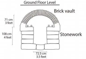
Figure 3. Section of the water supply tunnels inside the Monastery. Depth from the ground floor level varies from 0.5 m
to 1 m.
Firstly, we knew in advance the materials and constructive features of the tunnels, as we have drawn them at their inner sections inside the Monastery applying direct measuring, photogrammetry, and free drawing tools as Inkscape (Figure 3). Another important question to be considered was the existing granite rock layer under the Monastery, who served as a solid basement to the building, but whose depth and extension was unknown.
Finally, different degrees of moisture were detected on the stone façades of the monastery. They were particularly evident on the stonework surfaces near the drainage areas (Figure 4).
Figure 4. Eastern façade of the Monastery (Muro de los Nichos or Wall of the Niches), showing the stains of damp on the stone
masonry walls.
2.2 Description of the methods
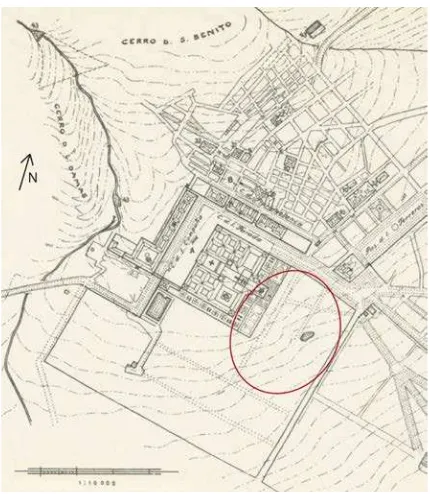
Figure 5. Topographic map of the Monastery of El Escorial and its surroundings; the circle defines the research area.
The external area of the Monastery that was chosen to apply the above mentioned techniques was the East slope that run downhill from the Muro de los Nichos to El Bosquecillo (Little Wood), covering an area of about 12 Ha (Figure 5).Originally a big pond was located in this place, about 750 m far from the Monastery, and its main function was to collect the water from the different sewage tunnels and channels coming from the Monastery and its orchard and gardens. The pond was replaced in the 1950s by a swimming pool, during the modernisation of the whole water supply system.
As we mentioned above, two main methods were applied in this research.
At a first stage we searched the ancient tunnel using low aerial oblique visible and infrared images, in order to set the limits to the area to be explored at the second stage with the RDP.
2.3 Instrumentation for the visible light spectrum and IR data collection
Along the first stage we decided to take two series of oblique aerial images: the fist one with a digital camera equipped both for visible and infrared light spectrum. After visiting the area we established in advance the conditions for IR, sensitivity, focus, and shutter, together with the bearing parameters and timetable according to the light hours.
Among the qualities of the digital camera was its lightness (only 650 g without battery) and its small size (128 x 93 x 129 mm) (Table 1). It included Fujifilm’s Hyper Utility Software HS-V” version 3, which became a useful tool with side-by-side image comparisons along with metadata analysis.
To take the images we used a barrage helium balloon, remote-controlled, which allowed the operator to visualise in real time the camera recordings, thus having the full control of the work. The PVC balloon was 5 m long, with a capacity of 9.6 m3 of helium. In order to detect the buried structures, it was furnished with robotics able to pan the camera 360º, with an azimuth of 90º.
Sensor 1/1.6” Type CCD (Super CCD HR) Visible – IR (400-900 nm) 9.0 million effective pixels
Image sizes 3488 x 2616
3696 x 1464 (3:2 format) 1600 x 1200
640 x 480
File formats CCD-RAW
JPEG (Exif Ver 2.2) Monie AVI (Motion JPEG) Image
parameters
Standard Chrome
B&W
ISO sensitivity AUTO
ISO 80 - 1600
Recommended ISO 200 or higher for IR photography
Table 1. Digital Camera IS-1 main specifications.
We searched firstly for perceptible terrain anomalies and their location within the research area. The aerial images allow observing both a wide area and details of its features.
With this aim we took the series of visible light spectrum images at 30 m high and 45º azimuth, selecting 28 mm focal length and a B&W 486 filter.
The following image series were captured in the infrared light spectrum at 40 m high and 47º azimuth, using a B&W 093 filter. Its built-in 10.7x, 28-200 mm optical zoom system International Archives of the Photogrammetry, Remote Sensing and Spatial Information Sciences, Volume XL-5/W2, 2013
minimised dust. On the other hand, through the use of an infrared cut or “hot mirror” filter on the lens, the camera could capture a visible light image very close in quality to that of a standard digital camera, adding flexibility and cost-effectiveness to the overall package.
This kind of IR camera detects any buried structures, showing them by means of contrasts between their traces and its impact on the terrain surface and the vegetation cover. Frequently these superficial changes cannot be perceived on the visible light spectrum, but IR brings them into light under particular conditions (Figure 5).
Figure 5. Comparison of the visible light spectrum and the IR images; the purple traces correspond to the main buried tunnel.
2.4 Instrumentation for the GPR data collection
Once the research area was limited, we introduced the GPR technique in order to get the accurate plan of the main sewage tunnel. This method does not need to establish any direct contact with the ground; it is fast and easy to manage, and can be worldwide used excepting on saline soils (which is not the case).
In our case, the maximum depth of the tunnel vault does not exceed 1 m, what could be considered as an advantage. On the other hand, the granite rocks that were spread all around the study area could introduce some distortions that must be considered on the later analysis.
GPR technique takes advantage of the fact that all buried materials in the ground have particular physical and chemical properties that affect the velocity of electromagnetic energy propagation, the most important of which are electrical conductivity and magnetic permeability. The reflectivity of radar energy that occurs at a buried interface is primarily a function of velocity changes, which is measured by differences
in the relative dielectric permittivity (RDP). The greater the change in velocity, the higher the amplitude of the reflected wave. The greatest factor affecting RDP is the moisture content and its distribution. Thus, in order to generate a significant reflection in a profile, the changes in GPR between two bounding materials must occur over a short distance. As the brick vault of the tunnel has different physical and chemical properties than the surrounding organic-rich surface soils or forested lands, significant reflections occurred at their interface. Similarly, differences between the underlying granite rocks and wet soils near the sewer water can be easily detected (Table 2). We used a GSSI UtilityScan with 400 Mhz and 900 Mhz antennas, on a SmattCar cart running at 0.5 m/s speed, that allowed collection of datasets each 2 m. Working under good conditions this instrument can detect structures buried at a depth of 6 m, what can be considered more than enough in this case study.
The GPR included a GPS in order to georeference each dataset, which made easier the later cartographic production.
GPR data were collected along closely spaced transects within a grid. This is an active method that transmits electromagnetic pulses from surface antennas into the ground, and then measures the time elapsed between the moment when the pulses are sent and the moment when they are received back at the surface (two-way travel time).
Material RDP
Air 1
Granite 4-6
Organic-rich surface soil 12
Forested land 12
Fresh water 80
Table 2. Relative dielectric permittivities (RDPs) of the geological materials in El Escorial.
As the radar pulses are transmitted through various materials on their way to the buried target feature, their velocity changes; and when the travel time of energy pulses is measured, and their velocity through the ground is known, depth in the ground can be accurately measured (Figure 6).
Figure 6. Radar energy cone of transmission and footprint.
The approximate size of the radiation footprint at a depth in the ground is estimated from the antenna frequency and the RDP of the ground through which the energy passes.
The cone of transmission becomes wider with depth when the relative dielectric permittivity (RDP) of the material is low. In high RDP materials the transmission cone is narrower, and its footprint radius at any depth is much smaller.
Figure 7. Reflection hyperbolas.
When hundreds or thousands of reflection traces are stacked together, a two-dimensional reflection profile is produced. Point source hyperbolas (diffractions) are generated as conical patterns from buried objects of a limited size, its apex denoting the actual location of the tunnel (Figure 7).
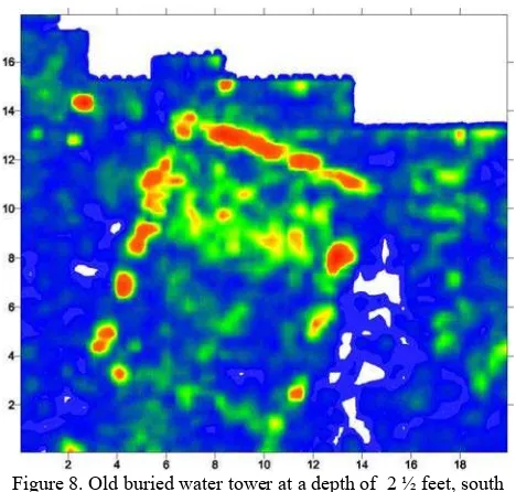
GPR georeferenced maps were produced in eight horizontal slices (distant ½ feet) showing the presence of the buried tunnels and an old water tower. They are similar to arbitrary level-maps in standard archaeological investigations, except they are showing the strength of radar reflections with certain depth intervals.
2.5 Results
After the field work and once back at the office we started with the data process and interpretation.
Radargrams were processed using the software RADAN 6.5, which allows introducing digital filters such as the finite and the infinite impulse response (FIR and IIR), space filters, migration, and Hilbert transform.
Figure 8. Old buried water tower at a depth of 2 ½ feet, south east slope. Units were chosen in this case according to the
historical 16th century distance units.
Once data are processed by removing the unwanted noise and the point source hyperbola tails (high angle reflections) are
removed to improve the accuracy, leaving only the reflections at the apex, the resulting reflection profiles are ready for additional image production (Soldovieri and Orlando 2009) (Figure 8). As the datasets can be exported and presented into different graphic file formats, it is easy to draw maps and to produce photorealistic 3D models. For example, the datasets from the horizontal slices can be imported into an open source visualisation program as 3D Studio Max and SketchUp, to render them into 3D shapes (Figure 9).
Figure 9. Map of the South-east area of the Monastery, showing the different sections of the drainage tunnel. The water tower is
located in D.
2.6 Discussion
In GPR technique, point-source reflections are generated from one distinct point feature in the subsurface. In this case the buried materials that generate this kind of point-source reflections could be individual granite rocks, metal objects, or ceramic pipes of old sewage systems, but also the 16th century drainage tunnels.
The ability to identify buried features is mostly a function of the wavelength of the energy reaching them at the depth they are buried. When features are different to large planar surfaces, wavelengh should be larger than the clutter and greater than about 75% of one wavelength or so in dimension.
On the one hand, a usual disturbance that affects the resolution of reflections in the ground is background noise, which is almost always recorded during GPS surveys. On the other hand, GPR radar antennas employ electromagnetic energy of frequencies that are similar to those used in television, FM radio and other radio communication bands, so there is almost always nearby noise generators of some kind.
3. CONCLUSIONS
The acquisition of reliable results with GPR techniques depends on the knowledge in advance of the type of soils and geologic materials, and their moisture. According to Conyers (2004), rain is the most important factor in resolving ancient structures in radar.
To define the depth of the prospective target features and their approximate dimensions and composition using estimates of RDP, the cone of transmission can be predicted, and a potential resolution of features of interest can be estimated from the footprint size using different frequency antennas.
Some of the important factors to be considered in choosing an antenna frequency are: the electrical properties of the ground at International Archives of the Photogrammetry, Remote Sensing and Spatial Information Sciences, Volume XL-5/W2, 2013
the site, the depth of radar energy transmission necessary to study the buried features, their size and dimensions, the site access, and the presence of possible external electrical interferences within the frequency spectrum of the antenna. Radio interferences and their sources must be previously identified, in order to choose an adequate antenna frequency so as to minimize that influence. pavements, which is the case of the tunnel under the Galería de Convalecientes, the expected high attenuation of electromagnetic energy due to the wet granite supposes a low penetration depth of the signal, not exceeding 1 m even using a 100 MHz antenna.
As a summary, the importance and accuracy of integrated transdisciplinary methods (as the geophysical and land survey methods) in the assessment of architectural sites has proved to be an interesting methodology. It supplies complementary datasets to the traditional ones which are got through photogrammetric or scanner laser methodologies.
4. REFERENCES
Aber, J.S., Marzolff, I. and Ries, J.B., 2010. Small Format Aerial Photography: Principles, Techniques and Geoscience
Applications. Elsevier, Amsterdam.
Andrés, G., 1965. Descripción de la fontanería del Monasterio de El Escorial hecha en 1645. In J. Zarco (ed) Documentos para la historia del Monasterio de San Lorenzo el Real de El
Escorial, Madrid, Vol. 8, pp. 219-318.
Basile, V., Carrozzo, M.T., Negri, S. and Nuzzo, L., 2000. A ground-penetrating radar survey for archaeological investigations in an urban area (Lecce, Italy). Journal of
Applied Geophysics, 44 (1), pp. 15-32.
Bozzini, C., Conedera, M. and Krebs, M., 2011. A new tool for obtaining cartographic georeferenced data from single oblique photos. In K. Pavelka (ed.) XXIIIrd International CIPA
Symposium. CIPA, ISPRS, Czech Technical University in
Prague, Czech Society for Photogrammetry and Remote Sensing, Prague (CD).
Conyers, L.B., 2004. Moisture and Soil Differences as Related to the Spatial Accuracy of GPR Amplitude Maps at Two Archaeological Test Sites. Tenth International Conference on
Ground Penetrating Radar, Delft, The Netherlands, pp. 1-4.
Conyers, L.B., Ernenwein, E.G. and Bedal, L.-A., 2002. Ground-Penetrating Radar (GPR) Mapping as a method for planning excavation strategies, Petra, Jordan. Society for
American Archaeology.
http://mysite.du.edu/~lconyer/petra/index.html (10 Sept. 2012).
Eppich, R., Almagro, A., Santana, M. and Almagro, A., 2011. The view from above. Overview and comparison of low cost aerial photographic techniques. In K. Pavelka (ed.) XXIIIrd
International CIPA Symposium. CIPA, ISPRS, Czech Technical
University in Prague, Czech Society for Photogrammetry and Remote Sensing, Prague (CD).
Gómez, R., 2008. Aplicación del radar de penetración en tierra (georadar) a la exploración no destructiva de yacimientos arqueológicos. Universidad de Granada.
Keay, S., Graeme, E., Hay, S., Kay, S., Ogden, J. and Strutt, K.D., 2009. The role of integrated geophysical survey methods in the assessment of archaeological landscapes: the case of Portus. Archaeological Prospection, 16 (3), pp. 154-166.
Martín Gómez, P., 1986. La evolución y los sistemas en la obra de El Escorial. In Fábricas y orden constructivo [La Construcción], IV Centenario del Monasterio de El Escorial.
Ministerio de Obras Públicas, Madrid, pp. 83-96.
Mirikovsky, J., Matinek, J. and Brus, J., 2011. Recosntruction of historical paths with using of small-format aerial photography. In K. Pavelka (ed.) XXIIIrd International CIPA
Symposium. CIPA, ISPRS, Czech Technical University in
Prague, Czech Society for Photogrammetry and Remote Sensing, Prague (CD).
Sánchez, J.I., San José, J.I., Fernández, J.J., Martínez, J. and Finat, J., 2011. Integration of hybrid outdoor and indoor surveying. A Case study in Spanish Renaissance style towers. In K. Pavelka (ed.) XXIIIrd International CIPA Symposium. CIPA, ISPRS, Czech Technical University in Prague, Czech Society for Photogrammetry and Remote Sensing, Prague (CD).
Santos, friar Francisco de los 1657. Descripción breve del Monasterio de San Lorenzo el Real de El Escorial, única maravilla del mundo, fábrica del prudentísimo Rey Philippo Segundo; ahora nuevamente coronada por el Cathólico Rey Philippo IV el Grande, con la majestuosa obra del pantheon y traslacion de los Cuerpos Reales, reedificada por nuestro Rey y Señor Carlos II después del incendio. Imprenta Real, Madrid. [Reeds. 1667, 1681, 1698; Facsimile 1984: Madrid, Ed. Almiar].
Soldovieri, F. and Orlando, L., 2009. Novel tomographic based approach and processing strategies for GPR measurements using multifrequency antennas. Journal of Cultural Herotage,
10 (1), pp. 83-92.
5. ACKNOWLEDGEMENTS
We wish to acknowledge the University of Alcalá for supoorting the CIPA Task Group 2 activities and their diffusion. International Archives of the Photogrammetry, Remote Sensing and Spatial Information Sciences, Volume XL-5/W2, 2013