Community forestry-based climate
change adaptation:
a practitioner’s brief
Community forestry-based climate change adaptation: a practitioner’s brief
RECOFTC - The Center for People and Forests Copyright © RECOFTC June 2016
Bangkok, Thailand
All photos courtesy of RECOFTC
Reproduction of this publication for educational or other non-commercial purposes is authorized without prior written permission from the copyright holders provided the source is fully acknowledged. Reproduction of this publication for resale or other commercial purposes is prohibited without written permission of the copyright holder.
A framework for climate change
adaptation through community
forestry
In 2014, the USAID Climate Change Adaptation Project Preparation Facility for Asia and the Pacific (USAID Adapt Asia-Pacific ) teamed up with RECOFTC – The Center for People and Forests to establish a demonstration site in the Bishnupur community of Sarlahi district of Nepal, on planning, financing and implementing community forestry-based climate change adaptation (CF-CCA).
The primary objective of the demonstration site, which is under the direction of the community’s women-led Community Forestry User Group (CFUG), is to promote learning and replication regarding the intersection of community forestry (CF), integrated climate change adaptation and women’s empowerment. Activities at the site involve assessing vulnerabilities through participatory approaches, identifying CF-CCA interventions, understanding locally available financial and technical support for adaptation, developing proposals for priority interventions and implementing interventions through the CFUG. The women-led CFUG participates in all program activities, and therefore benefits accrue directly to women with general benefits to the community as a whole.
Background and summary
There is growing recognition that those that have contributed the least to global carbon emissions, such as natural resource dependent communities in developing countries, will be the hardest hit by the impacts of climate change. Therefore, these communities must urgently adapt and gain access to the funds increasingly flowing from the international community in response to global climate change commitments. Further, because climate change impacts do not respect socially constructed boundaries between forestry, agriculture, livestock, water and socio-political dynamics, adaptation efforts must consider how these sectors intersect and the best ways to implement interventions for positive cross-sectoral impacts.
However, despite the range of tools available to support integrated adaptation (CARE 2009, ICEM 2011, ICIMOD 2011), practitioners still lack frameworks that effectively bridge social and ecological needs, allowing for assessment at a landscape level. And, the CF literature on climate change has generally not included the topic of adaptation, focusing instead on community-based mitigation and REDD+. Therefore, in 2012 RECOFTC published a series of case studies highlighting the potential role that CF can play in adaptation, providing the impetus to undertake the work that led to the present brief.
This brief presents an integrated CF-CCA framework for practitioners working in rural contexts, including natural resource management user groups and non-governmental and civil society organizations. The framework draws on an integrated landscape approach (Reed et al. 2014) to natural resource management, which aims to reconcile trade-offs, balance competing demands, integrate policies and identify priorities across different land-use sectors. Further, the framework aims to improve existing landscape management strategies for climate change adaptation by utilizing the institutional and material aspects of CF and CFUGs as an entry point for adaptation assessment and intervention. It focuses on enabling CFUG members to access local level financing in order to lead adaptation initiatives that address both climate and non-climate vulnerabilities. It places the poor, disadvantaged ethnic groups, castes and women at the center of all activities.
1 USAID Adapt Asia-Pacific is an integrated knowledge-transfer, capacity-building and technical-assistance program that helps eligible Asia-Pacific countries undertake climate change vulnerability assessments, link to appropriate climate funding organizations and prepare bankable climate change adaptation projects.
CF-CCA framework
The CF-CCA framework is comprised of three major phases with participatory monitoring and evaluation undertaken throughout the process. These include:
1. Vulnerability assessment;
2. Feasibility assessment, comprised of intervention prioritization and matching to locally available financing options; and
3. Intervention implementation.
The CF-CCA schematic
Phase 1: Vulnerability assessment includes:
• Review of all systems within the broadly defined ‘CF landscape’ and how different land use sectors interact;
• Assessment of current and future climate trends based on local knowledge and meteorological data; and
• Evaluation of political, social and economic factors and their effect on community level adaptive capacities and livelihood assets (human, social, financial, physical and natural assets).
Phase 2: Feasibility assessment includes the prioritization of adaptation interventions identified in the previous phase and identification of local financing opportunities. It also provides tools to guide project proposal development and the identification and assessment of potential partner institutions.
Phase 3: Implementation is comprised of priority intervention implementation.
The present brief will focus on Phases 1 and 2, taking the practitioner from understanding the CF landscape, to understanding the vulnerabilities.
Phase 1: Vulnerability assessment
Following a free, prior and informed consent (FPIC) process with relevant stakeholders, the CF-CCA framework begins with a community level vulnerability assessment, consisting of:
• The identification of climate threats and impacts;
• The assessment of threats and impacts according to community livelihood assets;
• The identification of vulnerabilities; and
• The identification of vulnerability response topics.
To aid practitioners in replicating this process, a series of tables have been developed to organize information and ease analysis. The tables allow for the clear collection, organization and evaluation of the climate change and socio-economic information needed to assess landscape vulnerabilities to climate change. Each table builds on the information captured in the previous one and should be filled in sequentially. Portions of each table are included below, with a brief description of how they should be completed. It is important to note that the tables have been shortened here for length and only show a glimpse of the Bishnupur experience. The various climatic variables and exposed sectors that are analyzed by the tables will depend on site-specific factors.
Both primary and secondary information will have to be collected from various sources to fill in the tables. Primary data should draw on common participatory rural appraisal and participatory action research approaches. Secondary data should come from CFUG guidelines and operational plans, district level government offices (including the District Forest Office) and forest and land use research institutes, among other sources. The table below provides a full list of the data collection tools and information sources that should be drawn on during the various stages of the vulnerability assessment.
Vulnerability assessment data collection tools
Stage Tools/sources of information
Quantitative analysis, focus group discussions, workshops, National Adaptation Programme of Action (NAPA)
Identification of climatic impacts
Transect walks, women’s mobility mapping, household data, well-being rankings, seasonal calendars, historical timelines, hazard mapping, pairwise ranking
Adaptive capacity and vulnerability assessment
Gender-based social and power mapping, stakeholder mapping, focus group discussions
Identification of response options
Focus group discussions, stakeholder workshops
Identification of financing opportunities
Office visits
CASE STUDY: PILOTING THE CF-CCA FRAMEWORK IN NEPAL’S TERAI
RECOFTC – The Center for People and Forests, with funding from USAID Adapt Asia-Pacific, has piloted the CF-CCA framework in the Bishnupur community of Nepal’s Terai. The framework has enabled a women-led CFUG to identify promising adaptation interventions and attain local adaptation financing.
Before beginning to fill out the tables, practitioners should conduct a Rapid Rural Appraisal (RRA) to ensure a holistic understanding of the landscape and how it is impacted by climate change. Priority sectors within the community forest landscape pertinent to the vulnerability assessment should be selected together with the community.
Using the vulnerability assessment tables
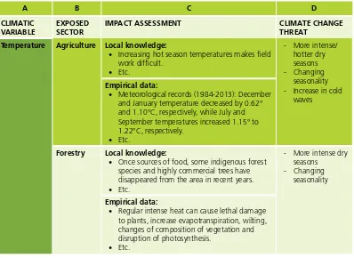
Table 1 facilitates the compilation of both the local knowledge of community members and meteorological data on climate change in order to clarify and assess the nature of climate threats and impacts. Using the various tools in Table 1, including historical timelines, focus group discussions and transect walks, practitioners should use this table to compare the impacts of climate change on various sectors and populations according to different information sources (i.e. local knowledge and meteorological data). Though the agriculture and forestry sectors are presented below, the priority sectors evaluated will vary depending on the context and should be identified with the community, as mentioned above. After the table is complete, the practitioner(s) will be able to determine the nature of the threats posed by different climate variables, such as temperature, wind, precipitation, etc. The table should be completed as follows:
• Column A: Climatic variables. List those variables determined by the climate that have potential to impact the community as a result of climate change, i.e. temperature, wind, rainfall, storms, etc. These are not the same as threats, which will be identified later, but rather outline key impacting variables.
• Column B: Exposed sector. List those sectors influencing and/or influenced by the community forest landscape (determined with the community). Note that these will repeat, as the table guides you to conduct the analysis for all the sectors under each climate variable.
• Column C: Impact assessment. Compare information of impacts gathered through local knowledge on the one hand (via the data gathering methods listed above) and empirical data (including meteorological and climate modeling data) on the other.
• Column D: Climate change threats. Based on an assessment of Column C, list the threats impacting the CF landscape. Threats are typically related to the climatic variables in that they identify the direction, frequency and severity of change in climatic variables that impact the community.
Identifying the CF landscape in Bishnupur
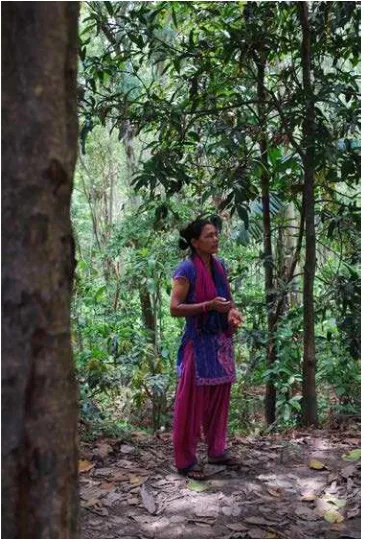
The Bishnupur community has a strong relationship with their community forest. It was the community’s women who planted the forest two decades ago in order to function as a natural barrier against flooding and riverbank erosion, which was cutting into their agricultural lands. Twenty years later, the community forest is officially recognized and continues to be a point of collective action for the community.
Table 1 (shortened): Identifying climatic threats and impacts
IMPACT ASSESSMENT CLIMATE CHANGE
THREAT
Temperature Agriculture Local knowledge:
• Increasing hot season temperatures makes field work difficult.
• Meteorological records (1984-2013): December and January temperature decreased by 0.62° and 1.10°C, respectively, while July and September temperatures increased 1.15° to 1.22°C, respectively.
• Etc.
Forestry Local knowledge:
• Once sources of food, some indigenous forest species and highly commercial trees have disappeared from the area in recent years. • Etc.
• Regular intense heat can cause lethal damage to plants, increase evapotranspiration, wilting, changes of composition of vegetation and disruption of photosynthesis.
• Etc.
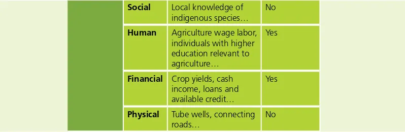
Table 2 further assesses the climate change threats determined in Table 1 (Column D) by looking at the threats’ impacts on the different assets within each sector and across different populations within the community. Drawing on the Sustainable Livelihoods Approach (SLA), these assets include natural,
Locating empirical climate information for Bishnupur
In order to gather climate information for Bishnupur the project team had to consult a number of sources. Though efforts were made to locate specific projections, downscaled climate modeling data for Nepal and the southern Terai region in particular, remains limited. However, two useful sources of other relevant climate change information included a synthesis report on the state of climate knowledge produced by the Climate and Development Knowledge Network (CDKN) for the Ministry of Science, Technology and Environment, and Nepal’s NAPA which indicates a number of likely climate trends.
In order to get a closer look at climate trends in the study area, climatic data on rainfall and temperature over the past 30 years was collected and analyzed from Karmaiya and Manusmara meteorological stations located near the study site in Sarlahi District: Karmaiya (5 km west) and Manusmara (20 km south). Additionally, ground water levels were assessed based on data from the Agriculture Development Office, Naktajhij, Janakpur, and the Ground Water Development Board, Jaleshwar.
social, financial, physical and human capital. Through this evaluation, it will become clear how sectors are impacted by climate change. A binary scale (i.e. yes or no) should be used to assess the existence of climate change impacts on the various assets. Though this may seem reductive, the final column provides those using the framework the opportunity to elaborate and add relevant details regarding the climate change impacts on various assets within each sector and how these impacts affect different populations differently. Once again, each exposed sector will be repeated, as all sectors are assessed within the context of each climate threat identified in Table 1.
Table 2 (shortened): Assessing threats and impacts through an asset lens
A B C D E F
ASSET ASSET DESCRIPTION IMPACTED? DESCRIPTION OF IMPACTS ON
Agriculture Natural Land, crops including local seed varieties, Defining Assets (from DFID 1999):
• Natural capital: The natural resource stock from which resources useful to livelihoods are derived. Natural resources may include land, water, forest, pasture, sea and minerals. • Social capital: A set of social relationships upon which people can draw in pursuit of their
livelihood goals. Social capital is gained from a range of factors including contacts, networks, trusting relationships, group and organizational memberships and access to wider societal institutions.
• Human capital: The skills, knowledge, ability and health needed to pursue livelihood activities. At the household level, this includes both the quantity (number of productive individuals) and the quality (what these individuals know and how hard they are able to work) of human resources. Human capital also includes knowledge and skills learned from formal education and through non-formal/experiential learning.
• Physical capital: The basic infrastructure related to transport, shelter, water management, energy, and communications as well as tools, machines, etc. which enable people to sustain their livelihoods. Physical capital includes both those things that people own and those that they have access to (roads, irrigation systems, telephone networks, etc.).
Social Local knowledge of indigenous species…
No
Human Agriculture wage labor, individuals with higher education relevant to agriculture…
Yes
Financial Crop yields, cash income, loans and available credit…
Yes
Physical Tube wells, connecting roads…
No
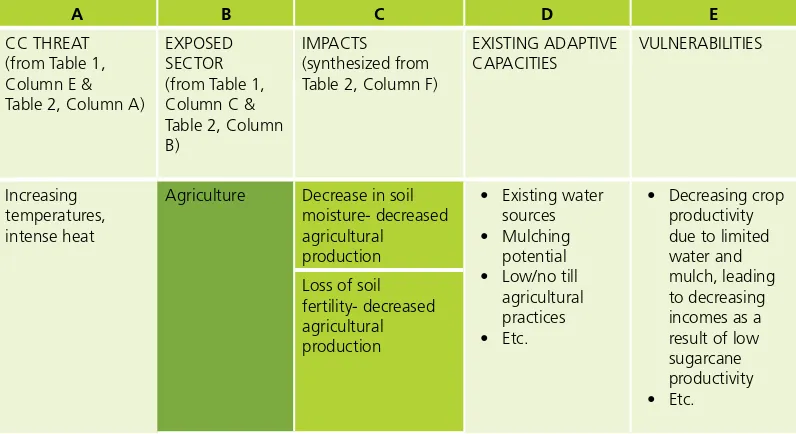
Table 3 (shortened): Identifying vulnerabilities
Agriculture Decrease in soil moisture- decreased
Identifying adaptive capacities and vulnerabilities in Bishnupur
The Bishnupur community has developed a number of capacities to deal with local environmental change. These include:
• Knowledge of and experience in rotational agriculture practices;
• Reforestation as a tool to mitigate localized flood and riverbank erosion events and to improve water quality and quantity;
• Political connections through local line agencies such as the District Forest Office, the District Soil Conservation Office and service providers such as the Federation of Community Forestry User Groups, Nepal, and other forest and environment networks;
• Knowledge of water related infrastructure, practices, and institutions (e.g. hand pump wells, upstream-downstream water management and underground water surveys); and
• Equitable and efficient knowledge and information sharing practices through the CFUG. Upon assessing the magnitude of climate threats, the way they are impacting the sectors and assets and the adaptive capacity of the community, a number of community level vulnerabilities emerged that are the result of both climate and non-climate threats. These included:
• Low crop productivity due to declining soil fertility and moisture, changing rainfall patterns, and an increasing number of pests and weeds;
• Decreasing incomes as a result of low sugarcane productivity and low negotiating power against sugar mills (previously a major income generator), which limits spending on other household needs;
• Limited ability to supplement livelihoods from the community forest resulting from decreased availability of multipurpose tree species;
• Water scarcity leading to increasing workloads for women (as primarily responsible for household water consumption) and decreasing potential for agriculture based livelihoods, in general; and
The final table, Table 4, serves two purposes: (1) to understand the severity of the identified climate change vulnerabilities, as a function of threat frequency and impact seriousness, in order to be able to prioritize intervention areas, and (2) to identify specific adaptation responses based on the magnitude and type of vulnerabilities identified. Column B of Table 4 allows practitioners to evaluate the ‘frequency of climate change threats’ listed in Column A. Column D evaluates the ‘seriousness of impacts’ of those vulnerabilities listed in Column C. This information should illustrate how vulnerable CFUG members are to different threats and allow for the community to identify a vulnerability rating related to each threat (of high, medium or low) to record in Column E. Vulnerabilities linked to highly frequent climate threats that cause very serious impacts would likely be labelled with a high vulnerability rating. Vulnerabilities linked to infrequent, but seriously impactful climate threats might receive a medium or even low rating, depending on how uncommon the threat is perceived to be. As with the prior tables, this subjective analysis should be undertaken together with the community.
These vulnerability ratings can then be used to guide the development of broad adaptation response ‘topics’ in Column F, as well as to help prioritize specific activities in Phase 2; these responses should crosscut both climate change threats and sectors and be based on CFUG inputs.
Table 4 (shortened): Identifying response options to vulnerabilities
At this point practitioners should move on to the feasibility assessment phase of the CF-CCA framework.
Phase 2: Feasibility assessment
In order to develop specific interventions related to the CF landscape, a feasibility assessment process must be undertaken based on target CFUG member and other stakeholder inputs. This process facilitates the articulation of possible adaptation interventions and, subsequently, the singling out of options that crosscut sectors relevant to the CF landscape. The feasibility assessment proceeds in a stepwise progression.
• Step 1: CFUG members and facilitators should begin by reviewing the vulnerability assessment and the intervention topics identified in Column F of Table 4. It is assumed that at least three intervention topics (general adaptation strategies, within which a number of specific actions can be taken) have been identified through the vulnerability assessment on the basis of recognized climate threats, vulnerabilities and existing adaptive capacities. The purpose of the feasibility assessment is to provide a logical and replicable series of steps for the evaluation of each response topic.
• Step 2: Using the provided template for evaluating adaptation topics, facilitators should assist in collating relevant information into a single ‘snapshot’ document in order to enable the selection of a more detailed course of action. Within the template (Template 1, below), sections 1 and 2 can be completed by the facilitators using information that was gathered during the vulnerability assessment. In contrast, most of the information needed for sections 3 and 4, on risks and potential impacts on sectors and stakeholders, should be completed based on CFUG member inputs. Information on existing assets can be drafted in advance by the facilitator, based on information within the vulnerability assessment.
• Step 3: Section 5 of the feasibility assessment (Template 1) facilitates the listing of potential experts and the expertise required for intervention topics. It should be compiled with target CFUG members. The facilitators should then build upon the list identified, if necessary, while considering
Zeroing in on areas of intervention
The following intervention areas were identified to address the vulnerabilities in Bishnupur.
1. Agroforestry systems: In order to support ecosystem and livelihood resilience, one adaptation response area identified was the strengthening of agroforestry systems. The purpose would be to diversify cropping and land-use systems in order to meet multiple objectives such as reduced dependence on a single crop, increased overall forest cover for ecosystem services, and increased multi-functionality including trees for livestock fodder and income generation.
2. Water management: Water shortage is understood by the community to be one of their most prominent vulnerabilities. Tackling this problem requires an eye towards a short term solution with long term sustainability. It would likely involve a ‘suite’ of options that would incorporate water conservation oriented landscape management. Responding to the issue of water shortage would have especially positive benefits for women in the community given that their increased workload is attributed directly or indirectly to water collection.
3. Riverbank stabilization: River flooding has been an ongoing challenge in the Bishnupur community. With a forecasted increased likelihood of more intense rainfall, there is a need stabilize the riverbanks in and around the community in order to minimize soil and land erosion, maintain the integrity of the community forest and reduce the impacts of flash flooding.
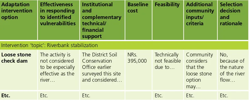
Template 1: Questionnaire template for evaluating selected adaptation topics (Feasibility assessment)
TOPIC: Riverbank stabilization
1. Describe how the topic responds directly to climate change vulnerabilities identified in the vulnerability assessment
The vulnerability assessment report identified a list of priority vulnerabilities being experienced by the commu-nity. This particular intervention responds in part to point number 7 on vulnerability to flooding. In addition to the infrastructure damage referred to, flash floods and changing upstream land use patterns have impacted the riverbed itself, leading to further widening of the river and gradual erosion of both community forest and agricultural land.
As described in the vulnerability assessment, river flooding has been an ongoing challenge in Bishnupur and surrounding communities, and in fact, this was the initial trigger for afforesting the former Bishnupur grazing lands. With a forecasted…
2. Relevance and links to the forest landscape
The Bishnupur CF was initiated as a direct adaptive response to river flooding. While upstream land manage-ment practices and climatic factors leading to flash floods are difficult for the community to directly influence, there are local level activities that can be undertaken to mitigate the damage of flash floods on housing, ag-ricultural lands and infrastructure. The community notes in their historic timeline that while there have been at least 2-3 significant floods in the area since the establishment and afforestation of the Bishnupur CF, the impacts of these floods…
3. Existing assets and risks associated with the intervention ‘topic’
Existing assets:
• Strong community motivation (a sub-committee has been formed for the purpose of implementing this activity)
• Etc. Risks:
• Maintenance costs and required knowledge may not be available to the community in the medium to long-term
• Etc.
4. Potential impacts on sectors and stakeholders (either outside of the CF landscape or within)
Sectors:
• Forest sector: trees and seedlings in particular are damaged during flash floods, CF land is being lost through riverbank erosion
• Etc. Stakeholders:
• Land owning community members, especially those in proximity to the river, would benefit from mitigated damage to cropland
• Etc.
5. Technical expertise/technology required (along with list of government service providers, organizations and other experts)
Technical expertise required:
• Engineering expertise specific to riverbank stabilization
• Etc.
Government line agencies offering potentially relevant expertise:
• The District Soil Conservation Office - planning and design of sub-watershed management, design and construction of check dams and gabion boxes, vegetative structures, facilitation of upstream-downstream linkages through whole river system
6. Listing of possible specific options under each intervention ‘topic’
General options for intervention:
• Construction of infrastructure based riverbank supports
• Etc.
Specific intervention options include:
• Loose stone check dam
• Etc.
• Step 4: Along with this process of adaptation topic evaluation, practitioners and CFUG members should conduct a review of the national, district and local level financing opportunities for adaptation related to intervention areas identified in Phase 1. This should be done with an understanding that no matter how well designed an adaptation intervention may be, it will not go anywhere if there are no resources to implement it. Furthermore, adapting to climate change is not a one-off activity, but rather requires iterative efforts to understand changing vulnerabilities and invest in reducing them. This process should identify:
· Key contact people for funding and technical support institutions; · Specific areas of funder interest and method of distribution; · Funding timeline information (e.g. funding cycle);
· Funder requirements (e.g. proposal format, reporting, executing entity); and · An assessment of the ‘likelihood of success’ for each funder.
In Bishnupur this stage consisted of a review of financing and technical support opportunities via the Department of Forests, the District Development Committee, the District Soil and Conservation Office and the Agriculture Development Office, among others. This information will feed into Table 5, and help to determine the most feasible response options.
Table 5 (shortened): Response option criteria identification and feasibility assessment
Etc. Etc. Etc. Etc. Etc. Etc.
• Step 6: After finalizing specific intervention strategies, the next step is for the facilitators and community members to develop a short ‘intervention work-plan’ for each strategy. Each work-plan should be brief (2-3 pages) and describe the specific steps to be undertaken and the intervention timeline. This will likely involve mapping the sites where interventions will occur, which can be done by target CFUG members. The work-plans should also include a description of all of the stakeholders and service providers relevant to the intervention, along with a revised and specified list of potential funding sources and relevant information on budgets and/or proposal submission cycles.
• Step 7: The specific intervention strategy and work-plan must be discussed, and ideally drafted, with target CFUG members for their comment and adjusted accordingly. During this process, community members should also identify indicators (one or more) to measure the effectiveness and success of the intervention(s) and propose a timeline for monitoring and evaluating the project. The results from these consultations should then be included in a revised intervention work-plan.
Following this process, practitioners should implement the adaptation actions identified, with strong participatory monitoring and evaluation systems in place and technical support as needed.
Stabilizing the riverbank in Bishnupur
From the identified response topics identified in Bishnupur, community members and other stakeholders decided to first pursue an adaptation response related to riverbank stabilization. Specifically, the project went forward with a bioengineering intervention that combined gabion boxes and vegetative check dams. Through a participatory process it was determined that this intervention was contextually and financially appropriate. It was also determined that the intervention could be supported by a number of governmental bodies, including the District Forest Office, the District Soil Conservation Office, the District Development Committee and others, for support in the form of technical expertise and subsidized materials.
Conclusion
References
CARE. 2009. Climate vulnerability and capacity analysis: Handbook. CARE International.
DFID. 1999. Sustainable livelihoods guidance sheets. Department for International Development (DFID), London, UK.
ICEM. 2011. Climate change adaptation and mitigation (CAM) methodology brief. ICEM – International Centre for Environmental Management, Hanoi, Vietnam.
ICIMOD. 2011. Framework for community based climate vulnerability and capacity assessment in mountain areas. ICIMOD, Kathmandu, Nepal.
OECD. 2009. Integrating climate change adaptation into development co-operation: policy guidance. OECD, Paris, France.
REED, J., DEAKIN, L., and SUNDERLAND, T. 2014. What are ‘Integrated Landscape Approaches’ and how effectively have they been implemented in the tropics: A systematic map protocol. Environmental Evidence 4 (2): 7.
RECOFTC’s mission is to enhance capacities for stronger rights, improved governance and fairer benefits for local people in sustainable forested landscapes in the Asia and the Pacific region.
RECOFTC holds a unique and important place in the world of forestry. It is the only interna-tional not-for-profit organization that special-izes in capacity development for community forestry. RECOFTC engages in strategic net-works and effective partnerships with govern-ments, nongovernmental organizations, civil society, the private sector, local people and re-search and educational institutes throughout the Asia-Pacific region and beyond. With over 25 years of international experience and a dy-namic approach to capacity development – in-volving research and analysis, demonstration sites and training products – RECOFTC delivers innovative solutions for people and forests.
RECOFTC – The Center for People and Forests
P.O. Box 1111 Kasetsart Post Office Bangkok 10903, Thailand Tel (66-2) 940-5700 Fax (66-2) 561-4880 [email protected] www.recoftc.org
Printed on recycled paper
USAID Adapt Asia-Pacific
CLIMATE CHANGE ADAPTATION PROJECT
PREPARATION FACILITY FOR ASIA AND THE PACIFIC
The USAID Adapt Asia-Pacific Project (2011-2016) helps countries in Asia and the Pacific obtain financing to address climate change impacts, through a combination of technical support in project preparation and capacity building at the regional, national and local levels for accessing climate change adaptation finance. For more information, please see www.adaptasiapacific.org