Herrera-Moreno, A. (2005). Historical Synthesis Of Biophysical Information Of Samana Region,
Dominican Republic. Santo Domingo, DR: Center for the Conservation and Eco-development of Samana Bay
and its surroundings (CEBSE, Inc.).
MANAGING FRESHWATER INFLOWS TO ESTUARIES
A. Herrera - Moreno
Historical Synthesis of Biophysical
Information of Samaná Region,
Dominican Republic
Dr. Alejandro Herrera-Moreno
Center for the Conservation and Eco-development
of Samaná Bay and its surroundings, CEBSE, Inc.
C
C
O
O
N
N
T
T
E
E
N
N
T
T
S
S
Págs.
Introduction 3
Material and Methods
3
Information compilation and analysis
3
Cartography 5
Acknowledgements 5
Physical aspects
6
Biological aspects
10
Mangrove Swamps
11
Western Coast of Samaná Bay
14
North Coast of Samaná Bay
14
South Coast of Samaná Bay
14
North and West Coast of Samaná Peninsula
14
Soft Substrate Estuarine Bottom
16
Prairies of marine grasses
16
Coralline reefs
17
Marine Biota
18
Fishing aspects
20
General characteristics of fishing activity
21
Identification of fishing types in the region of Samana
21
Shrimp fishery
21
Coralline reefs fishery
24
Deep Fishing in the border of the platform
24
Pelagic-oceanic fishery of FAD’S fishery
25
Pelagic-Coast fishery
25
Giant squid fishery
25
Current state of the main fishing resources
26
White Shrimp Penaeus schmitti
26
Groupers (Pisces: Serranidae)
26
Snappers (Pisces: Lutjanidae)
27
Diamond Squid Thysanoteuthis rhombus
28
Situation of fishing information
28
References
28
Annex I. Marine Biota
38
Annex II. Digital Bathymetric Models: 2 and 3-dimensional
49
I
I
N
N
T
T
R
R
O
O
D
D
U
U
C
C
T
T
I
I
O
O
N
N
This report is part of a study made for the Center for the Conservation and Eco-Development of
the Bay of Samana and its surroundings (CEBSE), with the objective of compiling physic,
biological and fishery information to have a basis for a Rapid Ecological Assessment.
Our specific objective is to characterize the biophysical regimen of Bay of Samana in regard to
freshwater contribution of Yuna and Barracote Rivers through the analysis of existing
information and identification of the most important lagoons to be address by the REA.
In order to do this we performed the following activities: a) collection and revision of historical
information on hydrology, circulation, bathymetry, water flows, habitat distribution and fish
resources of the Samana region, b) elaboration of a digital bathymetric model to help future
ecological and oceanographic studies, c) revision of the fish captures in some places to
complement the compiled information, d) revision and analysis of the information on the shrimp
fishery in the estuary complex at the West of the Bay of Samana.
The studied region is the estuary and the interior of Bay of Samana, although if we consider that
Samana region extends to Punta Arena in the north of the Samana Peninsula, and to Nisibón in
the south, we additionally considered all information in this area that could be relevant for future
research.
M
M
A
A
T
T
E
E
R
R
I
I
A
A
L
L
A
A
N
N
D
D
M
M
E
E
T
T
H
H
O
O
D
D
S
S
INFORMATION COMPILATION AND ANALYSIS
As a starting point of our work we took the previous coast and marine biodiversity review of
Samana region made by Betancourt (1998) for the CEBSE, which is here extended and
complemented. By visiting libraries and web sites of several national and international
institutions we completed the search of all inedited or published information including products
of projects and research papers on different themes. We reviewed the libraries of The Nature
Conservancy (TNC) and Center for Marine Biology Research (CIBIMA) of University of Santo
Domingo.
Special attention was directed to library of CEBSE because this institution has conducted
several general investigations of this region in which available information on natural resources
of the basin and the north and east of the peninsula has been compiled. In the same way, we
made direct contact with researchers or Cornell University and the Sea Education Association of
Woods Hole to get the paper research made by these institutions at Samana.
The information on the general biota was complemented with data of CIBIMA (1994) and the
most current information of the Project HISPABIOTA MARINA (Herrera-Moreno and
Betancourt, 2005, for the information on fishery we used the FishBase by Froese and Pauly
(2005), the review of Ramírez and Silva (1994), the report of ICRAFD (2001) and the results of
the Chapter on Dominican Republic of the Regional Fishery (Herrera et al., in press.).
During our search we included some international museums that have in their collections
material from Samana. They are: National Museum of Natural History (NMNH, 2005), Florida
Museum of Natural History (FMNH, 2005), National History Museum of Los Angeles County
(NHMLC, 2005) and the California Academy of Science Catalog of Fishes (CASCF, 2005).
Information of these museums regards to international expeditions of research ships Caroline,
Silver Bay y J. E. Pillsbury, which conducted biological sampling in the Bay of Samana and
nearby sea. General data about this is showed in Table 1.
Table 1. Data about some expeditions that have conducted biological surveys in the Samana region.
ship Month year Station Latitude N Longitude O Depth (m) Caroline Feb 1933 52 19° 10´ 25´´ 69° 20´ 55´´ 26-40 Silver Bay Oct 1963 5174 19° 22´ 00´´ 69° 27´ 00´´ 68 Pillsbury Jan 1970 1157 19° 06´ 18´´ 69° 01´ 00´´ 18-40
Information compiled on species of macroalgae, marine invertebrates and fish for Samana region
was organized in tables arranged by taxonomic group, following the order by Ruppert and
Barnes (1994). We tried to organized, from an ecological point of view, all species information
according to the habitat, such as those from the interior of the basin, those corresponding to
studies carried out in areas of the interior of the Bay of Samaná, swamps, marine grasses and
reefs of scarce development, and those corresponding to external areas of the Bay of Samaná, in
arrecifal habitats that are developed under the oceanic influence, although this subdivision can be
in some relative cases.
Total number of species per group were added for the “external” and “internal” areas and
compared to get conclusions on regional differences regarding group diversity and species
richness.
In connection with the fishing data, information was compiled whenever it was possible of all the
places of landing of the region of Samaná that go from Punta Arena until Nisibón.
To supplement the gathered information we carried out visits to several landing places including
that of the fishermen in Sánchez, where fishing activity is directly related with the estuarine
habitat. To compare the variations of the fishing resources in a gradient from the estuary to the
ocean we included the data of the eight landing places proposed by Sang et to the one. (1997):
Sánchez, Miches, Los Cacaos, Sabana de la Mar, Las Pascualas, Santa Bárbara de Samaná, Las
Galeras and Las Terrenas. The data of these places were organized in order from the interior to
the exterior of the bay offering a pattern of the species according to
swamp-estuary-prairie-reef-ocean habitats.
Whenever it was possible we took the coordinates of all the points where reports of species or
ecosystems/habitat information were found, for cartographic location. Some points where
biophysical data were obtained for the present work are indicated in Figure 1, where the places
of origin of biological oceanographic or fishing information are explained. In the case of
mangrove swamps and the marine grasses, there is not a precise geographical indication of study
places because all obtained information corresponds to the whole periphery of the region that is
indicated in the map and in particular the mangrove swamps to the coast West of the Bay of
Samaná.
C
ARTOGRAPHYThe digital bathymetric pattern was elaborated starting from the data of Coordenates UTM WGS
84 and depth obtained using the most recent bathymetric map available in the Military
Cartographic Institute, scale 1:30,000, adjusted to a previously designed grid. This way we
obtained maps of the general bathymetry –two and three-dimensional - both in the GOLDEN
SURFER Program Version 8, of the Golden Software, Inc., through the Krigging Model, by a
previous calculation of the adjustment variogram. These maps just pretend to offer a general
model of the topography of the submarine bottom to analyze its characteristics and to serve as a
basis for future work on ecosystem and habitat delimitations.
To support this and because the lack of information on the bottom types of the bay, the points
corresponding to the different available bottom types in the bathymetric map were equally
mapped, with the interest of having a preliminary idea of the distribution of the muddy habitat
associated to the contribution of the rivers.
A
CKNOWLEDGEMENTSWe thank the personnel of The Nature Conservancy, the library of the Center for Marine Biology
Research (CIBIMA) and especially the Center for the Conservation and Eco-Development of the
Bay of Samana and its surroundings (CEBSE), for the facilities offered during the search of
information. We thank to the Dr. Erik Zettler, Scientific Coordinator of Sea Education
Association of Woods Hole for his collaboration by supplying information of the Cruise C-191
on board of the Research Ship Corwith Cramer from Key West to Samaná. In the University of
Cornell we thank to M. Laba, S. D.Smith and S. D. DeGloria for sending us their work on land
use in the low basin of the Yuna River and to Ruth Sherman for sending us her excellent works
on the mangrove swamps of the Bay of Samaná.
C52 SB5174
P1157 SS
SN
1 2 3
4 5 6 7 8 9 10 11 12 13 14 15 16 17 18 19 20 21 22 23 24 25 26 27 28 29 30 31 32 33 34 35 36 37 38 39 40 41 42 43 44 45 46 47 48 49 50 51 2 1000 00 21 10000 2120 000 2 1300 00 214 0000
435000 445000 455000 465000 475000 485000 495000
Sabana de la Mar
Santa Bárbara de Samaná
Rí o Y u n a Rí o Bar raco te
Península de Samaná
Bahía de Samaná
Cayo Levantado
Miches
Océano Atlántico
Bahía de San Lorenzo Sánchez Las Pascualas Las Terrenas Las Galeras SAMANA HATO MAYOR Cabo Cabrón Punta Balandra Cabo Samaná El Valle La Jina
Estudios de los arrecifes coralinos Datos de oceanografía y plancton Sitios de desembarco pesquero
Colectas biológicas de expediciones internacionales Datos del régimen térmico del Programa PTSAVC
Figure 1. General map of Samana region with several points were biophysical information was obtained.
International expeditions: SB. BI Silver Bay Estación 5174, C52. BI Caroline, Estación 52 BI Pillsbury Estación
1157. Landing sites: 1. Las Cañitas, 2. El Cossón, 3. Bonita Beach, 4. Las Terrenas, 5. El Estillero, 6. Punta Coquito, 7. El Limón, 8. El Morón, 9. Las Canas, 10. El Valle, 11. Rincón Beach, 12. Punta Frillet, 13. La Playita, 14. Las Galeras, 15. Madama, 16. El Francés, 17. Punta Balandra, 18. Los Cacaos, 19. Las Flechas, 20. El Caletón, 21. Simi Báez, 22. Los Gratin, 23. Carenero, 24. Punta Lirio, 25. Villa Clara, 26. Anadel, 27. Samaná, 28. Los Cocos, 29. Las Pascualas, 30. Punta Corozo, 31. Arroyo Barril, 32. Los Róbalos 33. Los Corrales 34. Arroyo Hondo 35. El Majagual 36. Las Garitas 37. Arroyo Higuero 38. Punta Gorda, 39. Sánchez, 40. Naranjo Abajo, 41. Amado Cave, 42. El Coco, 43. Naranjo Arriba, 44. Sabana de la Mar, 45. Capitán, 46. Las Cañitas, 47. Magua, 48. Cabezú, 49. Arroyo Rico, 50. Ensenada de la Jina y 51. Miches (taken from Herrera-Moreno and Betancourt, 2003).
P
P
H
H
Y
Y
S
S
I
I
C
C
A
A
L
L
A
A
S
S
P
P
E
E
C
C
T
T
S
S
It can be said that physical/chemical oceanographic information on Bay of Samana is not
available at all. Surprisingly, the biggest estuary in the Dominican Republic -and one of the most
important of the Caribbean - it has never been object of a deep oceanographic investigation, with
a seasonal approach, including the physical and chemical factors that reveal the hydrological
pattern, related with the freshwater contribution of the Yuna and Barracote Rivers.
Ferreras et al (1990) and Ferreras (1991) offer the only well-known data on some oceanographic
parameters in the western region of the Bay of Samaná, between November of 1988 and August
of 1989. In four stations (Fig. 1) determinations of salinity, temperature, pH, and chlorophyll
concentrations were made, but only in the superficial stratum. These studies were carried out
with investigations of the plankton (Lysenko, 1991). This early physical-chemical
characterization showed big fluctuations of salinity (0 to 25 ‰), temperature (22 to 32 oC), pH
(7.5 at 8.5) and chlorophyll concentrations (0.53 to 6.9 mg/m3), which reveals the dynamic
nature of the region linked to the fluvial influence (Ferreras et to the., 1990; Ferreras, 1991).
However, these data are limited because they only refer to superficial samples that do not allow
to determine the position of the saline intrusion neither to describe the estuary type appropriately.
On the other hand, the works do not clarify in what phase of the tide cycle the samplings were
made every month, and the scarce data are not supplemented with previous meteorological
information during the samplings (for example precipitations) and do not cover a complete
annual cycle of observations.
In regard to the salinity, without doubts the most excellent parameter for the characterization of
the estuary, the data show the biggest variations in the proximity of the Río Yuna (0 to 4 ‰) and
the Río Barracote (0 to 12 ‰). The station between both rivers (19 to 25 ‰) it never showed
values so low indicating that, at least under the conditions of this sampling, the effect of the fresh
water was very located at the river mouth. Finally in their station farthest to the rivers, the values
varied between 18 and 25 ‰ indicating that important fluctuations of the superficial salinity can
be observed up to about 18 kms from the western coast (Fig. 2), although these can be related
with the contribution of other courses that exist in the riversides North and South of the bay. In
fact, in the South coast at Miches, Herrera-Moreno and Betancourt (2001) report salinities of the
order of 10‰ in the coastal area influenced by the La Mulata Creek and its tributary Los
Ranchos stream.
A hydrological study (1993) is mentioned, carried out by the Agency of Spanish Cooperation
(AECI) that seems to be the most complete previous oceanographic study of the estuary but we
had no access to those data for this work. It would be of great interest to manage such
information with comparative purposes, since that study contains values of salinity in surface and
bottom in an extensive net of stations in the western region of the bay from 12 years back.
As part of data search on the oceanographic characteristics of breeding areas of the hunchback
whales (Megaptera novaengliae) at Banco de la Navidad, Banco de La Plata and Samana Bay,
Betancourt and Herrera-Moreno (2005a) show information about the seasonal variation of the
superficial temperature of the water in the two nearest stations to the mouth of the Bay of
Samaná (Fig. 3) from Program PTSAVC
1(RSMAS, 2002).
1
PTSAVC (Average Water Superficial Temperature and Wind for the Carribbean) from the Rosentiel School of Marine and Atmospheric Science of Miami University presents twelve maps of Atlantic Ocean and Caribbean Sea, in which every month represents an average of twelve years of observations. From these maps it can be obtained information on superficial temperature if coordenates of the interest point are known.
0 5 10 15 20 25
Diciembre Enero Abril Agosto BS4
0 5 10 15 20 25
Diciembre Enero Abril Agosto BS8
0 5 10 15 20 25
Diciembre Enero Abril Agosto
BS7
0 5 10 15 20 25
Diciembre Enero Abril Agosto
BS6
BS4
BS6 BS7 BS8
2
1100
00
21
2000
0
440000 450000 460000 470000
Sabana de la Mar
Santa Bárbara de Samaná Río
Yuna
Río Barracote
Península de Samaná
Bahía de Samaná
Cayo Levantado
0 2500 5000 7500 10000 m
Figure 2. Variation of salinity in four stations (BS4, BS6, BS7 y BS8) in the western of Samana Bay, during four month from 1988 to 1989 (elaborated from data by Ferreras et al., 1990 and Ferreras, 1991).
25.5 26.0 26.5 27.0 27.5 28.0 28.5 29.0 29.5
E F M A M J J A S O N D
SS
SN
T
em
p
e
rat
u
ra °
C
Meses del año
72° 71° 70° 69° 68°
18° 19° 20°
SS SN
República Dominicana
Océano Atlántico
Samaná
Mar Caribe
Figure 3. Right. Dominican Republic Map showing the two stations of the Program PTSAVC closest to Samana Bay. Est. SS: 19° 06.0´ 69° 06.0; Est. SN 19° 12.0´ 69° 06.0´ Left. Seasonal Variation of Water Superficial Temperature at two the two stations indicated (from Betancourt and Herrera-Moreno, 2005a).
These data show the temperature seasonal tendency in the oceanic region adjacent to the bay and
although they do not correspond to the estuary area of our interest they offer, nevertheless, a
general comparative frame on the regional thermal pattern useful for future investigations.
Lastly, we have had knowledge that the Sea Education Association of Woods Hole,
Massachusetts has carried out oceanographic cruises on board the Research Ship Corwith
Cramer, in the Atlantic and Central Caribbean with some stations in the Bay of Samaná (SEA,
2004). We currently are waiting answer from this institution about possible relevant
oceanographic information since their investigation includes temperature, salinity, nutrients and
photosynthetic pigments.
In regard to sediments, we only know that slime and clay percentages reach 40 to 76% and
concentrations of organic matter are high, Ferreras et al (1990) and Ferreras (1991). To the
present time it has not been carried out any study of the bay that allows knowing the distribution
and types of superficial sediments, although the contribution of Yuna and Barracote Rivers are
very important, as it is shown in Figure 4. Types of sea bottom in Figure 5 give an idea of the
distribution of deposits and show in a general scale a gradient fromWest to East, according to the
contribution of the rivers. In the western end, near the mouth river, mud bottom prevails with
isolated patches of sand. This muddy area represents a deep basin of more than 30 m. The
distribution of the muddy biotope extends and combines with sandy and coralline bottoms
toward the East, although at a considerable distance of the West coast muddy patches are
observed. Evidence of coralline bottoms appeared at about 24 km from the western coast at
coordenates UTM (WGS 84) 457204 east. Such characteristics are shown in the Digital
Bathymetric Model of the Annex II.
0 5000 10000 m
Figure 4. Aerial picture Samana region from Cartographic Military Institute. It can be observed the influence of deposits from Yuna and Barracote Rivers at the west side of the bay.
2107 000 2 109 500 2 1120 00 2 114 500 21 170 00 2 1195 00 21 220 00 21 2450 0
439750 442250 444750 447250 449750 452250 454750 457250 459750 462250 464750
F F F F F F F F F F F F F F F F F F F F F F F F F
F F F
F F F F F F F F F F F F F F F F F F F F F F F F F F F F F F F F F F F F F F F F F F F F F F F
F F F F F F F F F F
F F F F F F F F F F F F F F F F F F F F F F F F F F F F F F F F F F F F F F
F F F
F F F F F F F F F F F F F F F F F A A A A A A A A A A A A AA A A A A A A A A A A A A A R R RR
R R R R R R R R R R R R R R R R R R Las Pascualas Santa Bárbara de Samaná Sánchez R ío Yu na R ío B ar rac ote Los Haitises Naranjo Abajo Naranjo Arriba Bahía de San Lorenzo Sabana de la Mar Punta Yabón Arroyo Barril Las Garitas Fondos fangosos Fondos arenosos Fondos rocosos Fondos coralinos F A R
TIPOS DE FONDOS
0 2500 5000m
Figure 5. Map of Samana Region used for elaboration of the Digital Bathymetric Model. Types of bottom are shown: mud, sand, rock and coralline.
All these elements indicate that one of the main objectives of future investigations of this estuary
should be address to know the characteristics of the hydrological regime during a tide cycle
through the analysis of the -horizontal and vertical space variation - of oceanographic
parameters. Also, collection of superficial sediments is very important in order to describe
physical-chemical characteristics. Such a characterization is key to know the behavior of the
estuary, the dynamics of the local deposits, to make inferences about the patterns of currents and
to offer the physical basis for the description of benthonic habitats.
B
B
I
I
O
O
L
L
O
O
G
G
I
I
C
C
A
A
L
L
A
A
S
S
P
P
E
E
C
C
T
T
S
S
Bay of Samaná characterizes by its marked contrast among highly fluctuating estuarine
conditions toward the West -related with the contribution of several courses of water - and more
stable oceanic conditions toward the East, in the Atlantic direction. This interaction among
terrestrial and oceanic influences, conditioned by the hydrological régime, local climate and the
very particular physiography of the region generates a gradient of ecological conditions among
the bay, the coastal area and the adjacent ocean that transforms Samana into a mosaic of
environments where lives a highly diverse biota, which is exploited with fishing purposes.
Main coastal and marine habitats directly related with the estuary system are: mangrove forest,
soft substrate bottoms, marine grasses on mud-to-sand substrate and the coralline reefs. Next
chapter is a discussion of a basic review on each of these habitats by Betancourt (1998) of the
Center for the Conservation and Eco-Development of the Bay of Samana and its surroundings.
MANGROVE
SWAMPS
Mangrove swamps of the region of Samaná have an estimated total surface between 82.1 km²
(TRD, 1992) and 130 km², equivalent to near 3% of the vegetable covering of the region
(CEBSE, 1993). The knowledge about the distribution of the swamps in the region comes from
different individual works whose analysis reveals that the most important extension of swamp
forest is located to the occident of the bay. Isolated patches exist –more or less conserved - in the
North coast and South of the bay, while in the Peninsula there are scarce mangrove sections to
the North and these are practically absent to the East.
According to the available data, the mangrove swamps at the interior of Bay of Samaná, from
Punta Palometa in the Northeastern end of the bay to Punta Yabón at the North of Sabana de la
Mar, occupy 40 km equivalent to about 92% of the extension of swamps of this region (Sang
and Lamelas, 1995). To the North and East of the Peninsula, according to Sang and Lamelas
(1995a) the extension of swamps decreases to less than 4 km (Table 2).
Table 2. Extension of the mangrove forest in different areas of Samana region.
Location Limits Coast line (km) Mangrove Extension (km)
Reference
Bahía de Samaná Punta Yabón to Punta La Palometa 140.0 40.0 Sang and Lamelas, 1995 Península Este Punta Palometa to Cabo Cabrón 39.5 0.1 Herrera andPeguero, 2004 Península Norte Cabo Cabrón to Punta Arena 63.4 3.6 Sang and Lamelas, 1995a
Total 242.9 43.7
W
ESTERNC
OAST OFS
AMANÁB
AYIn the western portion of the bay, associated mainly to the contribution of Yuna and Barracote
Rivers, it is developed the biggest mangrove forest of Samaná region and the biggest continuous
extension of this ecosystem in the Dominican Republic (CEBSE, 1993). With 17.6 km (Sang and
Lamelas, 1995), this forest occupies the whole occidental portion of the Samaná Bay, from the
town of Sánchez until the south margin of the Barracote mouth. General estimates on their
surface give 65 km² (Álvarez and Cintrón, 1984) and 62.6 km² (Pérez et al, 1994) which has
been more precise after the calculation from air pictures by Sherman (1996) reducing it to 42
km².
Typical species of the Caribbean mangrove swamps: Rhizophora mangle (red mangrove),
Laguncularia racemosa (white mangrove) and Avicennia germinans (black mangrove) are
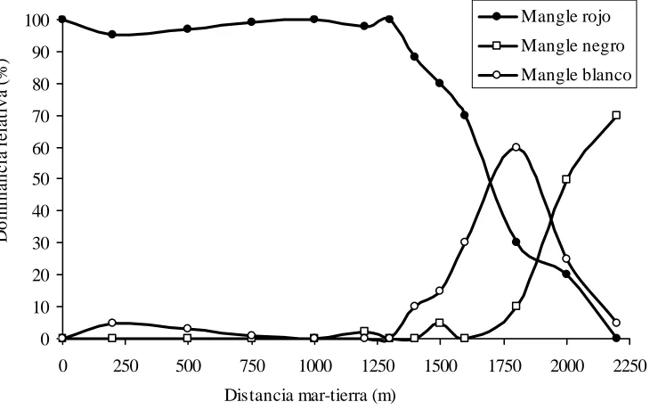
structured in that same order from sea to land, (Sang et al., 1994). Sherman (1994) offers the first
quantitative data of the frequency of these species (Fig. 6), the density and basal area of the trees.
0 10 20 30 40 50 60 70 80 90 100
0 250 500 750 1000 1250 1500 1750 2000 2250 Mangle rojo Mangle negro Mangle blanco
D
o
m
in
a
n
c
ia
r
e
la
tiv
a
(
%
)
Distancia mar-tierra (m)
Figure 6. Changes in relative abundance of three species of mangrove in the western portion of Samaná Bay (according to Sherman, 1994).
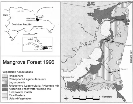
Figure 7. Species associations in the mangrove forest at the western portion of Samaná Bay (Sherman, 2003).
With support of physical-chemical data of the interstitial water (salinity, pH and nutrients) and
soil (organic matter, nutrients and soil grain) Sherman (1994) bases the ecological factors that
determine the abundance and distribution of mangrove species. This study and their later species
associations’ cartography (Sherman, 2003) in the mangrove forest (Fig. 7) constitute an
important starting point for the understanding of the structure and function of mangrove forests
at Samaná Bay, supplementing by this way previous descriptive studies (Álvarez and Cintrón,
1984).
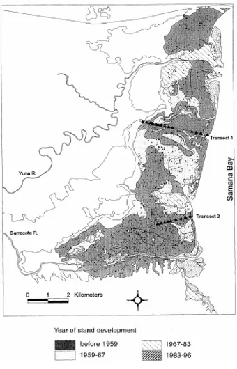
Later investigations of the University of Cornell have offered information on the soil cover in the
low basin of Yuna River (Laba et al, 1997), the historical evolution of the mangrove (Fig. 8)
through the analysis of aerial pictures (Sherman, 1994; 2000), the relationship between the
vegetation and the physical-chemical characteristics of the soil (Sherman, 1998; Sherman et al,
1998b), the roll of small-scale disturbances, like lightning, in the distribution and abundance of
mangrove (Sherman, 1998a; Sherman, 2000; Sherman et al, 2000), the disturbance-recovery
patterns before hurricanes (Sherman et al, 2001) and the space patterns of the biomass and the
productivity (Sherman et al., 2003).
After 1946 tsunami that destroyed great part of the forest (Álvarez and Cintrón, 1984), the
mangrove forest has rapidly colonized and expanded increasing its total area from 33 km² in
1959 to 47 km² in 1996, according to aerial pictures by Sherman (2000) (Fig. 8). These results
were in fact the starting point from Sherman et al. (2001) who evaluate the structural damage of
Georges Hurricane on the mangrove ecosystem in Samaná Bay and their later recovery. This
work that values the impact on the density and the interspecific differences in vulnerability
constitutes an important contribution to the knowledge of the dynamics of mangrove forests in
the case of great scale meteorological events.
N
ORTHC
OAST OFS
AMANÁB
AYSang and Lamelas (1995) describe the mangrove places along the North coast of the Samaná
Bay. The biggest swamp forest is reported between Los Corozos and Punta Mangle, occupying
1.6 km of coast line and an area of 0.75 km² (Sang and Lamelas, 1995). Red mangrove areas are
observed at Los Caceros, Majagual, Patosa, Escolástica and Cayito associated to freshwater
effluents (Sang et al, 1994). The presence of red mangrove is reported in marshes, behind the
sandy costs of the beaches Las Pascualas and Las Garitas. More to the east, in the bay of Santa
Bárbara de Samaná, there are small patches in the mouth of the stream Pueblo Viejo and in the
beach La Aguada (Sang et al. 1994).
S
OUTHC
OAST OFS
AMANÁB
AYÁlvarez (1978) offers general information about the mangrove between Sabana de la Mar and
Miches and Sang and Lamelas (1995) describe the mangrove places along the south coast of
Samaná Bay. The biggest mangrove tract is in San Lorenzo's Bay with an extension of 11 km²
associated to Caño Hondo and Chiquito Rivers that end to the southwest of this bay. In the north
coast of San Lorenzo's Peninsula, another extension of mangrove of 8.1 km of coast line related
with Yabón River is presented (Sang et al., 1994). Álvarez and García (1986) describe the
swamps of San Lorenzo's Bay and their associate biota. In the coast of Jina Bay, located to the
west of Miches, they are also located an important extension of red mangrove (Ferreras et al.,
1990).
N
ORTH ANDW
ESTC
OAST OFS
AMANÁP
ENINSULAIn the north coast of the peninsula mangrove are reported in several isolated points such as: La
Majagua, Playa Balatá, El Anclón, El Estillero, The Moron, Playa El Hermitaño and La
Ensenada of la Poza (Salazar and Peguero, 1994; Sang and Lamelas, 1995; Peguero, 1995;
Herrera-Moreno and Betancourt, 2001). A thick forest of red mangrove (Rhizophora mangle)
whose width varies between 16 and 65 m and it reaches a total extension of 26,000 m² occurs in
the periphery of the Laguna Maricó at Las Terrenas never referred before in the literature
(Herrera-Moreno and Betancourt, 2004). In the coast east of Samaná Peninsula, the mangrove
areas are much scarcer, being the most interesting one that of Caño Frío River mouth at Playa
Rincón (Herrera-Moreno and Peguero, 2004).
Figure 8. Development of mangrove forest in the west part of Samaná Bay. (after Sherman, 1996; 2000).
SOFT
SUBSTRATE
ESTUARINE
BOTTOM
The presence of numerous pipes and rivers that end in the coast at Samaná Bay contribute to
create estuarine conditions at a small scale, but little it is known about these habitats. The biggest
estuary in the region, whose influence even determines the distribution of other ecosystems like
marine grasses and coral reefs, is related with Yuna and Barracote Rivers. The Yuna River ends
in the northwest part of the Samaná Bay, with an extension of 5,495 km² and a flow that it
oscillates from 52 m
3s
–1to 57 m
3s
-1(monthly minimum averages) and it reaches an average of
144 m
3s
–1in the month of July (CEBSE, 1993). Barracote River ends in the southwest coast and
it is an important tributary of the Yuna River. Among these two rivers other courses of
freshwater of smaller flow occur, they are called from North to South: Boca Caimán, Boca
Grande, Boca del Barraquito, Boca del Caño La Ceja y Boca del Caño Los Pinitos; to the North
of the main outlet of the Yuna River there is a small pipe called Boca Colorao (Sang et al. 1994).
The important contribution of sediments that flows to this coast (Fig. 4) is responsible for an
extensive muddy basin that constitutes, for their extension and ecological value, one of the most
important biotopes of the bay (Fig. 5). These estuarine bottoms are compound for fine sediments
of terrestrial origin, probably lacking macro-vegetation. As we have already described, the
physical-chemical characterization of this area shows big fluctuations of all parameters in the
water, high slime and clay percentages in the sediments and high concentrations of organic
matter. The physical-chemical processes that take place when entering in contact the freshwater
with the sea water, make a large quantity of sediments associated to the organic matter to settle
down and in fact, the coast west of the bay is defined as of constructive type where the thickness
of the sediments can reach 15 m (Ferreras et al., 1990). Annex II Maps show that this deposition
seems to be much bigger in the area of the Barracote River where the flow of water is
comparatively smaller. This group of estuarine characteristics promotes the development of
peneid shrimp populations and other eurihaline species.
PRAIRIES
OF
MARINE
GRASSES
In the Samaná region marine grasses bottoms are represented by the fanerogams Thalassia
testudinum and Syringodium filiforme and in less proportion Halophila decipiens and Holodule
wrightii (Ferreras et al., 1990; CEBSE, 1993). Research carried out on this ecosystem
corresponds mainly to qualitative reports of observations from the border of the coast or diving
with snorkel to less than 10m (Ferreras et al., 1990; Sang and Lamelas, 1995). Because of this,
the compiled information is insufficient to have a complete idea of the limits of the marine
prairies in the region that have never been mapped. The most detailed study corresponds to Sang
and Lysenko (1994) that in 10 stations in the north coast of the Samaná Bay and to the south in
San Lorenzo Bay determined the distribution and extension of the marine grasses and estimated
the density and several foliar parameters of the main fanerogam species. In the north bank of the
bay development of marine grasses is reported starting from the beach Los Cacaos (Sang and
Lysenko, 1994) where the vegetation is developed in muddy to sandy soil. These fanerogam
portions are of variable extension with widths from 40 to 150 m growing from the very border to
a depth not bigger than 9 m, according to the limit of the observations (Sang and Lysenko, 1994).
Toward the east, starting from Cayo Levantado, these prairies are associated to coralline reefs. In
the south coast of Samaná Bay patches of marine herbs occur associated to several areas of the
rocky coast of Los Haitises and isolated patches to the south of San Lorenzo Bay. However,
starting from this point, it appears an extensive and more or less continuous area of marine
grasses that can reach up to 100 m starting from the border of the coast (Sang and Lysenko,
1994). In the west coast of the bay, development of marine grasses is not observed due to the
influence of the rivers Yuna and Barracote that impose conditions of high turbidity,
sedimentation and wide fluctuations of salinity (Sang and Lysenko, 1994). The marine prairies to
the north and east of Samaná Peninsula, from Punta Arena until Cabo Cabrón, have registered in
all the costs growing on sandy substrates, most of them related with ecosystems of adjacent
coralline reefs (Sang and Lamelas, 1995).
From these results it can be concluded that the presence of the marine grasses in the Samaná Bay
is only known by observations from the coast or by means of diving in a reduced interval of
depths (Sang and Lysenko, 1994). It allows saying that the marine grasses are broadly distributed
along most of the coast border of the bay but when not existing data on the central area, where
bigger depths are reached, it is not possible to establish the extension of this biotope. It might
possibly be the most extended sublitoral ecosystem in Samaná Bay and their surroundings, with
a distribution ruled by the sediment and hydrological conditions.
CORALLINE
REEFS
The studies of the reefs in the region of Samaná are scarce and limited. It is known that the
development of the coralline reefs inside the Samaná Bay is limited due to the influence of the
sedimentation and the turbidity associated to the typical estuarine conditions of this area.
However, to the present it has not been defined with accuracy which the limits of this influence
are neither mapped the reef formations of the region. For this reason distribution and
development is inferred starting from the results of particular studies or evidence of general maps
of bottom types (Fig. 5) or bathymetric (Annexed II). Ferrera et al. (1990) make some qualitative
valuations on the fluvial influence in the reef development and comment that just starting from
the 69
o21’(equals to UTM WGS 84 461054 AND) coralline formations begin to be observed.
The coralline development is increased toward the exterior of the bay with a bank in the north
entrance: the Canadaigua, and others of more extension to the east of the Ensenada de la Jina
(Sang, 1994), but the biggest development is to the north and east of the peninsula where a
strong oceanic influence exists. Geraldes (1994) describes the reef at 12 m of depth in front of El
Portillo, but the biggest study carried out in the reefs of the region corresponds to Sang (1996)
that offers data of the covering and the diversity of the communities of fish, corals, octocorals
and sponges from Las Terrenas to Cabo Cabrón at 21m of depth.
MARINE BIOTA
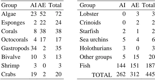
A total of 445 representative species of the coast and marine biota were collected, known for the
Samaná region: 262 species in the internal area and 312 in the external area. It includes it 72
species of algae: 24 rhodophyta, 16 phaeophyta and 30 chlorophyta, some 258 species of
invertebrates belonging to about 22 high taxonomic groups and 236 species of bony fish, sharks
and rays (Annex 1). Table 3 summarizes the number of compiled species -total and for areas- for
the best represented taxonomic groups. Although in comparative terms the internal area and the
external one have similar total number of species interesting differences can observed at the level
of particular groups.
For example, algae have 23 reports of species in the internal area while in the external area 52
species, including two cyanophytic species related with the reef habitat. For the invertebrates,
variation of the number of species reported in both areas is reported. This way, sponge,
octocorals and corals increase richness of species to the external area and lobsters and crinoids
only have reports outside of the bay. On the other hand, bivalve, crabs and gastropods, increase
their number of species toward the interior of the bay, where the only found reports of shrimps
and holothurians exist.
Table 3. Species number per area and total number of species per taxonomic group, considered in this study.. AI. Internal areas of Samana Bay, mangrove habitats, marine grasses and low development reefs. Áreas. AE: External area of Samana Bay, reef habitats under strong oceanic influence.
Group AI AE Total Group AI AE Total Algae 23 52 72 111 Lobster 0 3 3 Esponges 2 22 24 Crinoids 0 2 2 Corals 8 38 38 Starfish 2 1 2 Octocorals 4 17 17 Sea urchins 5 4 6
Gastropods 34 2 35 Holothurians 3 0 3 Bivalve 10 3 13 Other groups 5 15 20
Shrimp 3 0 3 Fish 144 151 187 Crabs 19 2 20 TOTAL 262 312 445
Although the heterogeneity of studies does not allow arriving to definitive conclusions the
ecological regularity that emerges of this compilation exists. In the first place, toward the
external area an increment exists -in some significant cases - of the number of benthonic
typically- reef species (for e.g. sponges, corals, octocorals or crinoids). Toward the internal area
an increment of macro-benthic groups linked to sedimentary habitats (for e.g. gastropods,
bivalve and holothurians). Although in these differences the nature and heterogeneity of the
compiled data as well as the intention and depth of the studies influence, we consider that the
they are also a reflection of the strong contrast between the richness of species inside of and
outside of the bay related with the environmental stability and variability imposed by two
different environmental circumstances: an area with fluvial influence and an under oceanic
influence.
In the case of fish, total numbers of species are almost same in both areas: 144 in the internal
area and 151 in the external one (Table 3). However, it includes 85 species that were only
present in the internal area, 92 species only reported for the external area and 59 shared species.
It evidences there is an ichthyofauna association typical for each habitat, as well as a movement
of species among them, and this is clear when families of fish that are disembarked in places of
the interior and in the exterior of the bay are analyzed (Chart 4).
Table 4. Presence and absence of crustracean and fish families in seven fishery places of Samana arranged according to a gradient from estuary to ocean. (after data from Sang et al., 1997 and current field data). Letters indicate landing places: SZ: Sánchez, M: Miches, LC: Los Cacaos, SM: Sabana de la Mar, LP: Las Pascualas, LG: Las Galeras y LT: Las Terrenas.
Habitat: Mangrove-Estuary-Prairies-Reef-Ocean
Landing places
Families SZ M LC SM LP LG LT Pristigasteridae X Ophidiidae X
Cynoglosidae X
Elopidae X
Engraulidae X X
Stromateidae X X X Trichiuridae X X X
Clupeide X X X X
Penaidae X X X X
Synodontidae X X X
Mugilidae X X X X
Centropomidae X X X Ephippidae X X X X
Gerreidae X X X X X X X
Scianidae X X X X X X
Carangidae X X X X X X X Lutjanidae X X X X X X X Haemulidae X X X X X X X Sphyraenidae X X X X X X X Scombridae X X X X X X X Polynemidae X X X X
Scaridae X X X X X X
Mullidae X X X X X X
Sparidae X X X X X X
Serranidae X X X X X X Holocentridae X X X X X X Priacanthidae X X X X X Balistidae X X X X X X
Belonidae X X X X X
Palinuridae X X X X X
Labridae X X X X X
Acanthuridae X X X X Ostracidae X X X
Pomacanthidae X X X
Coryphaenidae X X
For it, Table 4 has been elaborated starting from the information of the study “Composition and
diversity of fisheries in eight places of landing of Samaná Bay” (Sang et al., 1997) and the
information obtained during our visits for the present work. Data was arranged following an
ecological-geographical sense, from estuary to ocean. Gradual changes are observed in families
of fish represented in different landing places that vary according to their geographical position
regarding the different adjacent fishing habitats: estuary, mangrove swamps, marine grasses and
coralline reefs. In the areas of the interior, in the northwest of the bay (such as Sánchez), the
biggest captures of peneids shrimps and typically estuarine ichthyofauna are registered, with
demersal species belonging to the families Centropomidae and Mugilidae and pelagic such as
Engraulidae.
As we leave the influence of the estuary in the occident of the bay and begins the development
of marine grasses and coralline reefs (see Bathymetric Digital Model in Annex II), like it
happens toward Las Pascualas, Los Cacaos (to the North and center of the bay), Sabana de la
Mar and Miches (to the Southeast almost outside of the bay) it increases the representation of
neritic, demersal reef families like Serranidae, Holocentridae, Balistidae and Scaridae although
for the gradient effect some estuary and typically pelagic species are also registered.
In Las Galeras y Las Terrenas (outside of the bay and to the north of the peninsula) which
represent the end of the gradient toward the ocean, some of the previous families are absent,
while others of the marine-reefs grasses complex appear (indicating their relationship with these
ecosystems that reach great development outside of the bay) and pelagic families such as
Coryphaenidae and Istiophoridae appear, in agreement with the location of these places in the
proximities of open sea. This regularity has been the base for a proposal of a new regional
fishing classification that supplements the current one (based alone in commercial categories)
considering three ecological complexes of fishing for the estuary coast, marine grasses-coralline
reefs and oceanic area (Herrera, 2000).
F
F
I
I
S
S
H
H
I
I
N
N
G
G
A
A
S
S
P
P
E
E
C
C
T
T
S
S
Due to the richness in fishing resources, based in the ecological characteristics presented in the
previous sections, the region of Samaná has historically been very important place in the national
fish captures (CEBSE, 1993), concentrating about 34% of the fishermen of the country (CEBSE,
1996). According to the census of Colom et al (1994), the total number of fishermen estimated
for the country was 8,640, from which 3,223 for Samaná region, data has stayed according to the
last data that SERCM offers (2004). This chapter discusses information gathered on the fishing
activity in the region of Samaná, which has been enlarged and supplemented from the basic
compilation of Betancourt (1998).
GENERAL CHARACTERISTICS OF FISHING ACTIVITY
Fishing community of Samaná has shown through the years a continuous tendency of increment
in men's number, fishing arts and landing places. From 1991 at 1993, the number of boats passed
from 999 to 1029 and the number of fishing arts from 957 to 1120. In a longer interval of time,
1980 to 1993, the number of fishermen was increased from 1197 to 2103 (Silva and Aquino,
1993). In Sabana de la Mar and Miches, Aquino and Silva (1995) report that from 1980 to 1994
the number of boats was increased from 173 to 446, and the number of fishermen from 342 to
846. Currently, about 55 landing places have been detected (Fig. 1).
Technologically, the fishery in Samaná is completely handmade for all the fishing resources,
with some regional variations in the fishing means. Silva and Aquino (1993) and Aquino and
Silva (1995) reported a total of 1475 fishing crafts divided in wood boat
(30), fiber glass boats
(181),
pivots (26), ships (8) and wood kayaks (1230). According to the last data of SERCM
(2004), the proportion seems to have been maintained in a general way.
The fishing arts also vary regionally according to the port location and interest species. They are
different types of fishing cages, fishing lines, bottom nests, diving with or without equipment
(Silva and Aquino, 1993; Aquino and Silva, 1995) and the drag net locally known
“licuadora”(spanish for blender) (Sang et al., 1997). For the pelagic fishery, rafts are used
(León, 1996). No current data exist about the fishing arts although it is known that the traditional
ones have stayed in a general way and some new ones have been introduced and promoted,
especially by japanese specialists, like those used for pelagic or deep fishing (Hara 1999).
I
DENTIFICATION OF FISHING TYPES INS
AMANA REGIONIn order to organize fishing information gathered for this report we took fishery types by Herrera
et al. (in preparation) to adapt them to Samaná fishing situation, considering: a) fish resource
type and their importance, b) areas of fishing, c) fishing arts, d) intervals of depth and, d)
importance of the resource in the national fishing regulations. With these approaches we
identified fishery types that are indicated in Table 5 and described next.
Shrimp Fishery
Colom et al. (1994) they recognize like a national unit the shrimps fishery with gill nets and hand
nests of Sánchez in Samaná, described by Núñez and García (1983) and Silva and Aquino
(1993). This fishing activity began at the beginnings of 1960 with the closing of the rail
operations in Sánchez that forced local residents to look for other income sources. The most
important region due to its extension, abundance of the resource and number of fishermen is,
with no doubts, the western region Samaná Bay, where the flows of Yuna and Barracote Rivers
contribute to define an extensive estuary region.
The high productivity of the region makes this fishing area something unique in the country. In
the town of Sánchez, where landing place is located, three species of shrimps are disembarked
(Núñez and García, 1983): the Atlantic sea bob or “flechúo” Xiphopenaeus kroyeri, the pink
shrimp Penaeus durorarum and the white shrimp P. schmitti. This last shrimp can be considered
the key species since its represents around 86% (Sang et al., 1997) and 95% (Then et al., 1995)
of the total capture of shrimps.
An interesting aspect of this fishery is that, in spite of the time operating, has not still been able
to exhaust the estuary fishing potential due to its handmade character. Fishermen inform that
they can only operate their fishing arts in the proximity of the coast (Fig. 5) between Las
Pascualas and Punta Yabón (being the areas of more capture near Los Haitises and the river
mouth), at a depth not bigger than 7m. This fact limits them to fish in a narrow tract of about
100 km² or smaller, being the deep muddy basin outside (to see Bathymetric Digital Model in
Annex II) which might contain an important exploitable potential.
434750 437250 439750 442250 444750 447250 449750 452250 454750 457250
210 8500 21 11000 21 13500 211 6000 21 1850 0 2 12100 0 2 12350 0 2 12600 0 Las Pascualas Sánchez Rí o Y una R ío Ba rr a cote Los Haitises Naranjo Abajo Naranjo Arriba Caño Chiquito Bahía de San Lorenzo Río Yabón Punta Yabón Caño Colora do Ca ño B er ra quito Punta El Negro La Garita Arroyo Barril Arroyo Los Robalos Río Madrigal Arroyo Canta Maco Arroyo El Azabache Arroyo
Rancho Español Arroyo Juana Vicenta
0 2500 5000 7500 10000 m
Figure 9. Map of Samaná region showing the 7m depth isobar (striped zone). It indicates the approximate area of shrimp fishery, according to fishermen information.
Table 5. Fishery types in Samana Region. Abbreviations: Types: Co. Coast, De. Demersal, Es. Estuary. Pe. Pelagic, Re. Coral Reef. CP. Fishery Character: SSC. Commercial Small Scale, MSC. Commercial Medium Scale, SSA. Artesanal Small Scale, SI. Semi-industrial, S. Subsistence, TA. All year, ES. Seasonal. Fishery Arts:. At. Atarraya,
Ba. Balsa, Bu. Buceo, Chah. Chinchorro de ahorque, Char. Chinchorro de arrastre, Cd. Cordel, LC. Línea para calamar, Nb. Nasa del bajo, Nc. Nasa chillera, PA. Palangre (after Herrera et al., en preparation).
Name Key specie (local name/ latin/ common name) Type Depth. (m)
Art CP Time References
Shrimp fishery
Penaeus schmitti (white shrimp), P. duorarum
(pink shrimp), Xiphopenaeus kroyeri (Atlantic seabob)
De/ Es
0-5 Char, At
SSA TA Sang et al.,
1997
Reef fishery Several fish species (Lutjanidae, Haemulidae, Acanthuridae, Balistidae, Holocentridae, Serranidae, Pomacanthidae, Pomacentridae, Sparidae, Labridae) and crustacean (Majidae & Xanthidae), Panulirus argus (Caribbean spiny lobster) and Strombus gigas (queen conch)
Co/ Re 0-30 Nb, Bu Chah, Cd
SSA TA Sang et al.,
1997;
Deep fishery at the border of the plataform
Chillo Lutjanus vivanus (Silk snapper), chillo oreja negra L. bucanella (black-fin snapper), boral Etelis oculatus (queen snapper), roamo
Pristipomoides macrophtalmus, (cardinal
snapper), besugo Romboplites aerorubens (vermilion snapper), meros Epinephelus
mystacinus, (misty yellowedge grouper) E. flavolimbatus (misty grouper).
De 100-500
Pa, Nc, Cd
SSA TA Sang et al.,
1997; Arima, 1997; 1998; 19898a; 1998b; 1999; 1999a; 1999b Pelagic fishery or FAD’S fishery
Atunes, bonitos y albacoras: Thunnus albacares (yellowfin tuna), Euthynnus alleteratus (little tunny), Auxis thazard (frigate tuna), Katsuwomis
pelamis (skipjack tuna), macarelas
Scomberomorus sp. (mackerels), guatapaná Acanthocybium solandri (wahoo), dorado Coryphaena hippurus (dolphinfish) y la aguja Istiphorus albicans (Atlantic sailfish)
Pe - Co, Ba, Cu
SSA ES Sang et al.,
1997; León, 1996
Squid Fishery
Calamar diamante Thysanoteuthis rhombus (diamond squid)
Pe 300-750
LC SSC ES SERCM, 2004
Coast-Pelagic fishery
Carangidae (jacks), Clupeidae (herrings), Atherinidae (silversides), Hemiramphidae (balyhoo), Gerridae, Scianidae (drums), Centropomidae (snooks), Engraulidae
(anchiovies), Sphyraenidae (juvenile barracuda), tiburones (bull, blackfin, hammerhead, nurse, reef, lemon sharks).
Pe/ Co
0-10 At, Co, Cu
SSC TA CFRM, 2004
The arts used for the shrimp fishery accidentally capture a great quantity of species that can
occupy up to 54% of the total capture. Sang et al. (1997) found that in this sub-capture could be
represented up to 24 families of fish and two of crustaceans. Among this species are:
Cetengraulis edentulous (Atlantic anchoveta), Cynoscion jamaicensis (Jamaica weakfish),
Stellifer colonensis (stardrum), Micropogonias furnieri (whitemouth croaker), Mugil hospes
(hospe mullet), Centropomus ensiferus (swordspine snook), Callinectes sapidus y C. danae (blue
crabs). It is known that a small proportion of small fish are discarded before landing, so there is
no information available about them. This is a small scale fishery activity that extends all year
including the prohibited period from February to March. Se conoce que una proporción de peces
pequeños se descartan pero no existen cifras pues éstos no llegan al sitio de desembarco. This is
a fishery of small scale that takes place during the whole year excluding the months of prohibited
from February to March (Presidential Decree 3546-73).
Coralline Reef Fishery
Coralline reefs fishery in Samaná is typical for its more external areas where reef development
exists and takes place approximately until 30 m of depth, Sang et al. (1998). Key species of this
type of fishery belong to a group of typically reef families like, Lutjanidae, Haemulidae,
Acanthuridae, Balistidae, Holocentridae, Serranidae, Pomacanthidae, Pomacentridae, Sparidae
and Labridae. These species are distributed in the interval of depth from the mangrove swamps
and marine grasses (juvenile stages) and the coralline reefs (mature stages) for what the value of
each one of them in number and weight in the capture can vary locally and according to the art
and the fishing place. For example, in the reef fishery with several different arts at Sabana de la
Mar, Sang et al (1998) report that half of the capture is occupied by Lutjanidae (33%),
Haemulidae (15%) and Scaridae (8%) while in Las Terrenas the most abundant families are
Scaridae (28%), Lutjanidae (22%) and Serranidae (14%).
Among the species more frequently reported in the captures of the reef are: Lutjanus analis
(mutton snapper), L. griseus (gray snapper), L. synagris (lane snapper), Ocyurus chrysusrus
(yellowtail snapper), Cephalopholis cruentata (graysby), Epinephelus striatus (Nassau grouper),
Sparisoma aurofrenatum and Scarus taeniopterus (parrotfishes), Haemulon aerolineatum, H.
flavolineatum, H. plumieri and Acanthurus bahianus (Chart 5).
This fishing also has three species of crabs (Majidae and Xanthidae) as key species: Carpilius
corallinus (coral crab), Mitrax spinosissimus and Stenocionops furcata (spider crabs), although
the most important crustacean is the lobster Panulirus argus, (Herrera-Moreno and Betancourt,
2003). This is a small scale, handmade, coastal fishery dedicated in their biggest part to the
domestic market. It is characterized by their variety of arts -in agreement with their diversity of
species - that includes fishing cages, gill nets, diving with or without equipment and all line
types. This fishery takes place during the whole year (Chart 5). Collected data shows that the
resources are subjected to high exploitation. There are not precise information on production.
Deep Fishing in the border of the platform
In the north and east coast of Samaná Peninsula takes place a deep fishing below the bank in
depths among 100 to 500 m. The most important areas are those where the 100 m can be reached
with a handmade boat at short distance from the coast, because the platform is narrow or because
the lines of depth come closer to the coast due to geographical accidents (Sang et al., 1998;
Arima, 1997; 1998; 1998a; 1998b; 1999; 1999a; 1999b). The fishing is directed to lutjanids and
serranids with seven key species that occupy more than 80% of the captures and in order of
importance include Pristipomoides macrophtalmus (cardinal snapper), Lutjanus vivanus (silk
snapper), L. bucanella (blackfin snapper), Rhomboplites aerorubens (vermillion snapper), Etelis
oculatus (queen snapper), Epinephelus mystacinus (misty yellow-edge grouper) and E.
flavolimbatus (Table 5). The analyses of captures reveal that this group of species is dominant in
capture weight, although their proportions can vary according to the locality, depth and fishing
art. Fishing arts include fishing cages, lines and
drag net. This is a small scale, handmade fishery
that exploits big specimens, takes place along the year and seems to concentrate on annual spawn
places well-known places for the fishermen.
Pelagic-Oceanic Fishery or FAD’s fishery
Pelagic fishing in Samana is documented by León (1996) and Sang et al. (1997). It is practice
with drag nets, gill nets, and others
,
with or without fish aggregating devices (FAD’s).
Key
species are several migratory species from family Scombridae: Thunnus albacares (yellowfin
tuna), Euthynnus alleteratus (little tunny), Auxis thazard (frigate tuna), Katsuwomis pelamis
(skipjack tuna), Scomberomorus sp. (mackerels), Acanthocybium solandri (wahoo); Coryphaena
hippurus (dolphinfish) and Istiphorus albicans (Atlantic sailfish) (Table 5). It can include some
sharks incidentally. This is a handmade fishery of small scale with seasonal character.
Nevertheless, since it involves so many species -the migratory bigger part of them - the fishing
stays during the whole year according to availability of the resources.
Pelagic-Coast Fishery
CFRM (2004) reports this fishery type that takes place particularly near the coastal border on
bottoms of marine grasses that, as we said before, practically border the coast of Samaná. It
includes a big group of species of the families Carangidae (jacks), Atherinidae (silversides),
Hemiramphidae (balyhoo), Scianidae (drums), Sphyraenidae (juvenile barracuda), Gerridae
(mojarra), Clupeidae (herrings), Centropomidae (snooks) and Engraulidae (anchovies). These
last four families are generally associated to freshwater flows near the coast, where we can also
include family Mugilidae (mullet). This fishing also includes some juvenile sharks. The captures
are carried out along the year, both for key or incidental species, mainly with gill nets, cast nets,
lines and sometimes fishing cages, according species
.
It is considered a moderately exploited
fishery, although there is not data for a complete evaluation. Stocks can also be affected by the
coastal contamination.
Giant squid fishery
Recently, Japanese specialists introduced in Samaná the fishing of giant squid. The key species is
the diamond squid Thysanoteuthis rhombus, epipelagic oceanic species that reaches 100m of
longitude of the mantel and 20 kg of weight. Their distribution includes tropical and subtropical
waters of the world. Fishing depth varies from 300 to 750m and the place of main fishing is
located 3 miles to the east of El Francés, in the coast east of Samaná Peninsula. Squids are
captured using a squid drop line fishing. This is a small scale, handmade, incipient fishing that
takes place seasonally although fishing stations are not clear because migration of this species in
oceanic waters are practically unknown (Table 1). According to the authorities at the
secretary of Coastal and Marine Resources, this resource will turn to be on of the most important
in next years (SERCM, 2004).
CURRENT STATE OF THE MAIN FISHING RESOURCES
White Shrimp Penaeus schmitti
Shrimp is fished only in shallow areas (less than 7 m) of the western region of the Bay of
Samaná using 250 cast nets and 350 drag nets operated from 512 kayaks
with a 2 men average
crew. About 900 fishermen participate in this fishing (Colom et al., 1994) and although the
resource seems to be over exploited in its traditional areas, the contribution of specimens that
come from deep areas, 10m to 30 m where it is not fished, it seems to contribute to maintain
certain capture levels, always promoted by the high price of the product (about $180 to $240
Dominican pesos per pound = US$6- 8/pound). Fishermen argue that it has taken place a
reduction of the captures and an increment of the fishing effort. There is not any biological study
of this shrimp in the Dominican Republic and the stocks have never been evaluated. As the
fishermen referred us, the use of no-sustainable fishing arts takes place secretly in hours of the
night.
Sang et al. (1998) offer minimum (0.7cm) and maximum (7.3 cm) values of cephalotorax length
(including the rostrum), with an average of 3.5 cm, values that are in the order of those that we
detect during our visit. There are a serious lack of biological and fishing information of the
resource and the levels of exploitation. The Decree 3546-73 prohibits the fishing of the shrimp
between February and May, but it doesn't clarify to which species is directed the prohibition and
fishermen admit that fishing stays all year. Between 1963 to 1980 landings varied from 125 to
200 MT (Fisheries Development Limited, 1980). According to CFRM (2004), the capture annual
averages is in the order of 184 TM, that which is below the productions that are already
achieving with culture methods in other regions of the country with amounts of 400 TM (FAO,
2001).
Groupers (Pisces: Serranidae)
In the region of Samaná serranids are represented in the reef fishery with thirteen species (Sang
et al., 1998). Cepalopholis fulva, C. cruentata (graysby), Epinepehelus guttatus and E. striatus
are registered practically in all fishing areas, although presence and diversity of species in the
captures vary according to the landing place. This way, in Sánchez they do not register serranid
captures while to the north of the peninsula it is common to find them (Table 6). Serranids are
fished with lines, fishing cages
(made of wire or fiber similar to those used for lobster fishery),
or diving for reef fishing, but for deep fishing, it is used palangre, lines and fishing cages. This
indiscriminated fishing and the absence of effective regulations have made that numerous species
are in critical situation in some regions. Sizes registered in biological-fishing studies of Samaná
(Sang et al., 1998) reveal that all the reef fishing species are being captured before reaching their
size of first maturation.
Table 6. Presence and absence of serranid and lutjanid species of fishery places of Samana in seven landing sites, arranged according to a gradient from estuary to ocean (from data by Sang et al. (1997) and current field data. Letters indicate landing places: SZ: Sánchez, M: Miches, LC: Los Cacaos, SM: Sabana de la Mar, LP: Las Pascualas, LG: Las Galeras and LT: Las Terrenas.
Estuary-Prairie-Reef-Ocean
Landing places
Family Epecies SZ M LC SM LP PS LT LG Serranidae Ephinephelus guttatus X X X X X X X
Ephinephelus striatus X X X X X X
Ephinephelus cruentatus X X X X X X
Ephinephelus fulvus X X X X X
Alphestes afer X X
Hypoplectrus puella X
Mycteroperca venenosa X X X
Ephinephelus itajara X X
Ephinephelus adscensionis X X
Mycteroperca bonaci X
Serranus tabacarius X
Serranus. Phoebe X
Paranthias furcifer X
Lutjanidae Lutjanus analis X X X X X X X
Lutjanus synagris X X X X X X X X
Lutjanus apodus X X X X X X X
Lutjanus griseus X X X
Ocyurus chryrsurus X X X X X X X
Rhomboplites aurorubens X X X X X X
Lutjanus mahogoni X X X
Lutjanus buccanella X X
Lutjanus vivanus X X
Lutjanus cyanopterus X
Etelis oculatus X X
Apsilus dentatus X X
Pristipomoides macrophthalmus X X
Snappers (Pisces: Lutjanidae)
In the region of Samaná Lutjanidae family is represented in the reef and deep fishery for
fourteen species (Sang et al., 1998). Lutjanus analis, L. griseus, L. synagris and Ocyurus
chrysusrus are registered practically in all reef fishing areas, while bigger species as Lutjanus
vivanus, L. bucanella, Etelis oculatus, Pristipomoides macrophtalmus and Romboplites
aerorubens are reported in deep fishing in the border of the platform. Lutjanids are fished with
the same arts that the serranids: lines, bottom fishing cages, or diving for reef fishing
palangre
and lines for deep fishing. As we pointed out for the serranids sizes registered in the
biological-fishing studies reveal that all species in the reef biological-fishing are being captured before reaching their
size of first maturation (Table 6).
Diamond Squid Thysanoteuthis rhombus
Diamond squid are captured from boats with a three men crew, using a squid drop line fishing.
Currently, only 20 fishermen, 6 boats and 12 fishing arts are involved in this capture that can
reach up to 4 to 5 squids per day. There are not any biological study about this species whose
migratory patterns, feeding behaviour and breeding are unknown. (Kazunari et al., 2001).
S
ITUATION OF FISHING INFORMATIONFrom information analyzed we can conclude that biological-fishing studies in the region of
Samaná, as in the rest of the country, have had a descriptive character, for all approaches:
economic, commercial, technological, social, taxonomic or evaluation of fishing arts. Strictly
biological-fishing investigations of long term, with evaluations of key species stocks are
practically nonexistent.
In spite of the importance in fishing biology of studying the composition for sizes and sex of
populations under exploitation with a time-space approach, there are not studies in this respect
and many population data lack statistical consistency. Some works in Samaná have been directed
to carry out estimates of capture and the sustainable maximum effort (Silva, 1995) but they have
been single isolated efforts. One of the serious problems of the regional fishing investigation is
the lack of evaluations of fishing stock. Resources have generally been exploited without being
studied, as has already happened with the shrimp and is beginning to occur with the giant squid.
One of the main problems for the regional fishing organization is the lack of continuous series of
temporary, properly standardized data that allow analyzing regional and national tendency of the
captures. In Samaná the statistical data has been kept for some years by CEBSE (Silva and
Aquino 1994; Silva et al., 1995; Aquino and Silva, 1995) but this effort could not have
continuity. It has been demonstrated that the concept of the fishing ecological complexes
constitute an approach of high methodological and practical value (Silva and Colom, 1996;
Herrera, 2000).
R
R
E
E
F
F
E
E
R
R
E
E
N
N
C
C
E
E<