Emergency Risk Management Unit, Health Security and Emergency Response Department, SEARO, WHO
Earthquake in Maw Laiak Township, Sagaing Region, Myanmar.
Date and time of Incident: 13.04.2016, 19:20 hrs. Local timeIncident Site Mapping and affected area photos Caption1: Map showing the epicenter of the earthquake in Myanmar Caption 2: First responders transporting an injured patient to near by hospital in India.
Earthquake Information
The Sagaing region is in seismic zone and earthquake of small scale has been reported from time to time Annex 1). This time, it was reported that the epicentre is in the jungle, 174 miles north-west of Mandalay, in Sagaing Region and it is sparsely populated area. WHO is in contact with MoH and Township Medical Officers in affected areas have been mobilized to evaluate damage. So far there are no reported casualties and there is only some damage in infrastructure. OCHA is
HIGHLIGHTS
• On 13th April 2016 at 19:20 hrs local time, a powerful earthquake, scale of 6.9 M, epicenter at 134 KM
inland struck south west of Maw Liake Township, Sagaing Region in Myanmar. The tremors were felt in the northern parts of its neighboring countries; Thailand, China, Bangladesh and India.
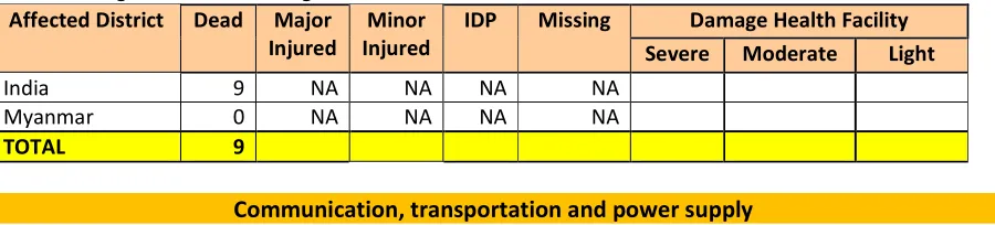
• 9 persons in India have died due to collapse of partially damaged infrastructures and homes. A few injured cases were referred and treated in nearby hospitals in Myanmar and India. A few houses and two pagodas were reported partially damaged in Myanmar.
• WHO Country Offices in close collaboration with Ministry of Health and selected Health Partners are on
monitoring social and local media, but no reports on impact on eventual affected people or only small damages have been reported up to now, i.e. only small damages have been reported up to now, e.g. partial damage of a school roofing in Kalay Township, one house was collapsed in Kalay Downtown, Kalay Township, two pagodas affected in Mon Ywa and Yin Mar Pin Districts in Sagaing Region. The Mawlaik town, Shwe Bo and Monywa did not report any damage at the moment.
Casualties and Damage
Table showing casualties & damaged infrastructure and homes Affected District Dead Major
Injured
Minor Injured
IDP Missing Damage Health Facility Severe Moderate Light
Communication is still working. All phone line are working.
Transportation
Difficult to access affected areas as news are scattered all over the media channels. The data sets and photos are available more in social media sites like face book and twitter.
The shaking pattern of the earthquake seems strange this time as it moves more towards India like a wave and it may have travel along with the fault line. Usual circular spreading fashion was not noted.
Myanmar is on its long Thyingen Water festival and new year holidays. Information is coming in bits and pieces.
Response Activities
The government and UN offices are closed for one week for water festival in Myanmar which will open next week. However, WHO Country office has managed availability of staffs during emergency.
On 14 April (this morning), WHO followed up further and has been informed by Regional Health Director that all TMOs (including Kaley Wa and Tant Se townships as well as Monywa) reported no casualties had been brought to these hospitals.
WHO Regional and Country Offices have expressed readiness to provide any support if MoH may need at this time.
The Emergency Operations Center (EOC) has not been activated yet.
Media Reporting
Information from Local resident: (one house was collapsed in Kalay Downtown, Kalay Township) Facebook
Thit Htoo Lwin Website - http://www.thithtoolwin.com/2016/04/blog-post_364.html (reported about 2
pagodas affected in Mon Ywa and Yin Mar Pin Districts in Sagaing Region) Myanmar Breaking News -
http://myanbnews.blogspot.co<http://myanbnews.blogspot.co/>m/
Annex 1
Historical data on earthquake event in Sagaing, Myanmar
about 6 hours ago 4.6 magnitude, 67 km depth Mawlaik, Sagain, Myanmar
about 21 hours ago 6.9 magnitude, 134 km depth Mawlaik, Sagain, Myanmar
December 01, 2015 UTC 4 months ago 4.2 magnitude, 35 km depth Monywa, Sagain, Myanmar
November 27, 2015 UTC 5 months ago 4.5 magnitude, 34 km depth Monywa, Sagain, Myanmar
5 months ago 5.4 magnitude, 39 km depth Monywa, Sagain, Myanmar
5 months ago 4.3 magnitude, 104 km depth Mawlaik, Sagain, Myanmar
7 months ago 4.1 magnitude, 90 km depth Mawlaik, Sagain, Myanmar
Source: http://earthquaketrack.com/p/myanmar/sagain/recent
WHO Contacts
WHO Country Office, ERM / IHR unit - SEARO
No Name Designation Phone Fax Email Address
1 Dr Maung Maung Lin ERM Focal Point, NPO, WCO [email protected]
2 Dr Gyanendra Gongal Scientist, IHR Unit, HSE, SEARO
1 Dr Kyaw Win Vijaya Nath
Technical Officer, ERM, HSE, SEARO