Cambridge Advanced
Learner Guide
Cambridge
International AS & A Level
Geography 9696
In order to help us develop the highest quality Curriculum Support resources, we are undertaking a continuous programme of review; not only to measure the success of our resources but also to highlight areas for improvement and to identify new development needs.
We invite you to complete our survey by visiting the website below. Your comments on the quality and relevance of Cambridge Curriculum Support resources are very important to us.
www.surveymonkey.co.uk/r/GL6ZNJB
Contents
Contents 3
Section 1: Syllabus content – what you need to know 4
Section 2: How you will be assessed 5
About the examinations 5
About the papers 5
Information about each paper 6
Section 3: What skills will be assessed 8
Section 4: Example candidate response 9
A. Question 10
B. Mark scheme 11
C. Example candidate response and examiner comments 13
Section 5: Revision 15
General advice 15
Paper 1 and Paper 2 advice 17
Paper 3 and Paper 4 advice 18
Revision checklists 20
Section 1: Syllabus content – what you need to know
This guide explains what you need to know about your Cambridge International AS & A Level Geography course and examination. It will help you plan your revision programme and will help to show you what we are looking for in the answers you write.
It can also help you revise by giving you a revision check list in Section 5, where you can tick off topics you have been taught and you have learned for the examination.
By studying this Cambridge International AS & A Level course you will develop:
an understanding of the principal processes operating within physical geography and human geography
an understanding of the causes and effects of change on natural and human environments
an awareness of the usefulness of geographical analysis to understand and solve contemporary human and environmental problems
the ability to handle and evaluate different types and sources of information
the skills to think logically, and to present an ordered and coherent argument in a variety of ways
an excellent foundation for studies beyond Cambridge International A Level in Geography, in further or higher education, and for professional course.
We recommend that you have previously studied on and completed a Cambridge O Level or Cambridge IGCSE or an equivalent level of study in Geography.
For this Cambridge International AS Level Geography course you will study Core Physical and Core Human Geography. And for the Cambridge International A Level Geography course you will study Advanced Physical and Advanced Human Geography.
Section 2: How you will be assessed
About the examinations
For AS Level you will take Paper 1 and Paper 2.
For the full A Level you will take Paper 1 and Paper 2, as well as Paper 3 and Paper 4.
Find out from your teacher which papers you will be taking, and when you will be taking them.
About the papers
The table below gives you further information about the examination papers:
Paper
Time and
marks
Questions
% of total
mark
What is tested
and % of total
You answer questions from two sections, Section A and Section B.
In Section A, you need to answer all three data response questions on Core Physical topics. Each question is worth 10 marks.
In section B you will answer one
structured question from a choice of three, worth 30 marks.
50% if
You answer questions from two sections, Section A and Section B.
In Section A, you need to answer all three data response questions on Core Human topics. Each question is worth 10 marks.
In section B you will answer one
structured question from a choice of three, worth 30 marks.
50% if
You will answer questions on two
different optional topics. Each topic will have one structured question (worth 10 marks) and a choice of two essay questions (worth 20 marks).
Paper
Time and
marks
Questions
% of total
mark
What is tested
and % of total
You will answer questions on two
different optional topics. Each topic will have one structured question (worth 10 marks) and a choice of two essay questions (worth 20 marks).
25% A Level Knowledge 20%
Information about each paper
Paper 1
tests the three Core Physical Geography topics: Hydrology and fluvial geomorphology Atmosphere and weatherRocks and weathering
There are two sections:
Section A (30 marks) contains three questions. You must answer all of them. Each question is worth 10 marks, and includes a geographical resource. You must try to answer each question equally well.
The questions make use of resources such as maps, graphs, photographs, diagrams, data tables and sometimes survey maps (1:25000 and 1:50000) so you should practice your skills and ability to understand and write about these. You may be asked to draw and label appropriate diagrams and sketch maps, so you should practice this.
Section B (30 marks) contains three longer structured questions. You must answer only one of them.
There will be a question on each physical core topic.
Paper 2
tests the three Core Human Geography topics: PopulationMigration
Settlement dynamics
Section A (30 marks) contains three questions. You must answer all of them. Each question is worth 10 marks, and includes a geographical resource. You must try to answer each question equally well. Here questions may cover two or more topics because there are strong interrelationships between all three topics.
The questions make use of resources such as maps, graphs, photographs, diagrams, data tables and sometimes survey maps (1:25000 and 1:50000) so you should practice your skills and ability to understand and write about these. You may be asked to draw and label appropriate diagrams and sketch maps, so you should practice this.
Paper 3 and Paper 4
These are separate question papers. Paper 3 has twelve questions on the Advanced Physical Geography topics below (three on each topic). You must answer questions on two different topics. You choose two topics and you must answer the question worth 10 marks, and one of the two questions worth 20 marks.
The Advance Physical Geography topics are:
Tropical environments Coastal environments Hazardous environments
Hot arid and semi-arid environments
Paper 4 has twelve questions on the Advanced Human Geography topics below (three on each topic). You must answer questions on two different topics. You choose two topics and you must answer the question worth 10 marks, and one of the two questions worth 20 marks.
The Advanced Human Geography topics are:
Production, location and change Environmental management Global interdependence Economic transition
In both Paper 3 and Paper 4 there is one 10 mark question, and two 20 mark questions in each topic. For two topics you must answer the resource based question (10 marks).
You also have a choice of two essay questions and you must answer one of them on the same topic as your 10 mark question.
The 10 mark question in each topic will make use of resources such as maps, graphs, photographs or diagrams. You will use these resources to show your understanding of geographical ideas. It will not matter if you have not studied the place/example in a resource as you are only expected to interpret information and show ideas that can be used in any similar situation.
You need to organise your writing well and use relevant case studies or developed examples. The essay questions (20 marks) require you to use your skills of evaluation.
Revision
Section 3: What skills will be assessed
The examiners take account of the following skills areas (assessment objectives) in the examination papers
Knowledge
Understanding and application Skills
Evaluation
It is important that you know the different weightings (%) of the assessment objectives, as this affects how the examiner will assess your work. For example, assessment objective 4 (AO4: Evaluation) is worth 12% of the total marks in Paper 1, and 12 % of the total marks in Paper 2. However, in Paper 3 and Paper 4, AO4 is worth 40% of the total marks.
AO1 Knowledge Remembering facts and ideas
1.1 give definitions and explanations of relevant geographical terms and concepts
1.2 show working knowledge of relevant principles, theories and models
1.3 recall accurately the location and character of places and environments
1.4 show knowledge of physical and human processes and factors.
2.1 understand the complex and interactive nature of physical and human environments
2.2 understand how processes bring changes in systems, distributions and environments
2.3 recognise the significance of the similarities and differences between places, environments and people. 2.4 recognise the significance of spatial scale and time
scale
2.5 apply geographical understanding to unfamiliar contexts.
AO3 Skills How you study data and come to conclusions about it
3.1 interpret a variety of types of geographical data and sources and recognise their limitations.
3.2 Use geographical data to identify trends and patterns 3.3 Use diagrams and sketch maps to illustrate
geographical features
3.4 demonstrate skills of analysis and synthesis of geographical information
3.5 communicate geographical evidence, ideas and arguments
AO4 Evaluation How you assess, judge and consider information in different contexts.
4.1 assess the effects of geographical processes and change on physical and human environments 4.2 consider the relative success or failure of initiatives 4.3 assess how the viewpoints of different groups of people,
potential conflicts of interest and other factors interact in the management of physical and human environments 4.4 critically evaluate geographical principles, theories and
Section 4: Example candidate response
This section takes you through an example question and learner response. It will help you to see how to identify words within questions and to understand what is required in your response. Understanding the questions will help you to know what you need to do with your knowledge, for example, you might need to describe something, explain something, argue a point of view, apply the knowledge in a different way, or list what you know.
All information and advice in this section is specific to the example question and response being
demonstrated. It should give you an idea of how your responses might be viewed by an examiner but it is not a list of what to do in all questions. In your own examination, you will need to pay careful attention to what each question is asking you to do.
This section is structured as follows.
A. Question
Words in the question have been highlighted and their meaning explained. This should help you to understand
clearly what is required by the question.
B. Mark scheme
This tells you as clearly as possible what an examiner expects from an answer to award marks.
C. Example candidate response
This is an answer by a real candidate in exam conditions. Good points and problems have been highlighted.
D. How the answer could have been
improved
This summarises what could be done to gain more marks.
E. Common mistakes
This will help you to avoid common mistakes made by candidates. So often candidates lose marks in their
A. Question
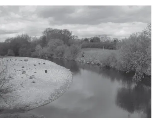
Hydrology and fluvial geomorphology
1
Fig. 1 shows features of a meander on the River Swale in North Yorkshire, UK.
(a)
Identify
the features labelled in Fig. 1.
(i) A
(ii) B
[2]
(b)
Describe
the processes that lead to the features you have identified in
(a)
.
[5]
(c)
Briefly
explain
how a floodplain is formed.
[3]
Fig. 1
A meander on the River Swale in North Yorkshire, UK
Identify The examiner will be expecting you to give the name of feature A and B in Fig. 1.
Describe The examiner will be expecting you to give the key characteristics of the processes that lead to the formation of the features shown in Fig. 1.
B. Mark scheme
All the questions in Paper 1, Section A are point marked. This means that one mark can be gained for each separate point made. No additional marks are available for the same point stated in a different way, or if more points are made than there are marks available.
Question Answer Marks
1(a)(i) Identify the features labelled in Fig. 1. A River cliff
1
1(a)(ii) B Point bar / slip off slope 1
(b) Describe the processes that lead to the features you have identified in (a)
Credit can be given to diagrams where they help illustrate an answer.
River cliff
Velocity is fastest on the outer bend of the river where the channel is deeper and there is less friction. (1)
This is due to the water being flung towards the outer bend as it flows around the meander. (1) This causes greater friction, which results in more erosion which deepens the channel. (1)
This lateral erosion results in undercutting of the river bank (1) and the formation of a steep sided river cliff.
Point bar
On the inner bend water is low velocity (1) being a low energy zone, deposition occurs resulting in a shallower channel (1).
This increase of friction further reduces the velocity (thus further reducing energy) (1), encouraging further deposition.
Over time a small beach of material builds up on the inner bend (1); this is called a point bar/slip off slope.
5
Question 1a
You need to learn the terms and features which are specified in the syllabus as well as additional terms which would be expected to help give and explain answers for that topic.
Question 1b
The answer here is explaining the processes which lead to the features.
The use of key terms in the mark scheme help to guide the examiner as to what to expect in an answer.
You are expected to use geographical terms, such as friction, lateral erosion, velocity, undercutting.
As this paper is point marked, where you see a (1) in the text, this means that you can gain a mark if your answer included the point which was immediately before it.
Question Answer Marks
1 (c) Briefly explain how a floodplain is formed.
Candidates may suggest:
Meander migration erodes the valley floor over time, to create a wider and flatter valley (lateral erosion) (1) Sediment is transported within the river (by solution and suspension) or along the river bed (by saltation and traction). When a river floods over the surrounding land it loses energy and deposition occurs. (1)
This process is repeated, causing a build-up of sediment on the flood plain (1)
Reference to the shallower depth of water flowing over the surface results in frictional drag and a reduction in velocity (speed of flow).
As the floodwater loses energy, the capacity and competence of the floodwater is reduced, leading to deposition.
The heaviest materials (bedload) are deposited first nearest the channel, as these require the most energy to be transported and therefore build up around the sides of the river forming raised banks known as levees. Finer material such as silt and clay continue to flow further over the floodplain before they are deposited (alluvium).
Regular flooding results in the building of layers of nutrient rich alluvium which forms a flat and fertile floodplain.
The slopes of the river valley border the edge of the floodplain. These slopes are known as the bluff line, and mark the edge of the floodplain.
The width of the flood plain is a result of the meander migration and lateral erosion. Answer may be via a well annotated diagram.
3
Question 1c
The word ‘briefly’ in the question helps to indicate to you that a full and detailed explanation is not required, as explaining how a floodplain is formed could be quite lengthy.
The mark scheme includes more guidance to help show range of answers that could be given and gain credit.
Question 1c
The bullet points suggest the three basic points that a good answer would include.
Lateral erosion (helping to widen the valley floor and create the area of floodplain).
Now let’s look at the sample candidate’s response to the question and the examiner’s comments.
C. Example candidate response and examiner comments
Question 1 a.(i) Levee (ii) Point bar
b. A point bar can occur due to secondary flow of a river. This is
called the helicoidal flow in which fast velocity water erodes the
outside of the meander. This water collects sediment and can
transport it on the bottom of the river where it loses velocity on the outside of the meander. Due to the loss of velocity, the sediment is then deposited thus creating a point bar.
A levee can be created natural or man-made. A levee can form
natural due to repetition of a flood. This is when a river exceeds its
bank full discharge and deposits the sediment on a flood plain up to
the river bluffs. The levee can be built higher due to the repetition
of the process in which a levee can be built up by layers.
c. a floodplain is formed when a river experiences high levels of water and exceeds its bankfull discharge. A floodplain ends at the river bluffs. The land which is flooded experiences deposition and sediment is deposited when the water infiltrates the floodplain.
Total mark awarded = 5 out of 10
1
2 3
4
5
Geographical terms are used such as bankfull discharge, bluff, infiltration. Clarity needed on when deposition of sediment happens, and when the sediment that has been deposited is visible. Infiltration does not directly cause sediment deposition.
6
The focus needs to be on the processes rather than the classification of the feature.
4
Good use of terms, although this information is relevant for the next question. Make sure you read all the questions carefully.
5
Helicoidal flow is a secondary flow which helps to transport the material from the outside of the bend to the inside. Make sure your definition is clearly understood.
1
Using two sentences here will help, so that helicoidal flow is not interpreted to be the fast velocity.
2
6
The candidate here should use the term ‘erodes’ or ‘entrains’ and not
How the answer could have been improved
1 (a)(i) The candidate incorrectly identifies feature A. The position of the label A is important, as it is below bankfull, and is part of the vertical channel profile. A levée is a feature beside the channel rather than within it.
1 (b) The specific processes are erosion, transportation and deposition. The candidate mentions erosion, but does not give detail as to the type of erosion. Other specific detail is missing, for example the way that the deposition process can result in the different sizes of sediment being deposited within the point bar in different places. The candidate focuses on the result of helicoidal flow, rather than writing about the range of processes, which together, form the point bar.
There is opportunity, through describing the second feature, to gain more marks. However, the landform of a levee was not correctly identified from the figure. Whilst clearly described, does not help focus on the description of the processes which lead to the formation of the feature. The candidate includes material when describing levées which would have been better placed in the answer for q1(c). No credit is given here for material which could be credited in the next question.
1 (c) The candidate mentions that deposition occurs, but does not explain why. They correctly identify the term river bluffs, but again don’t link it is with the explanation of the formation of flood plains (relating to meander migration and lateral erosion). The candidate needed to suggest that there are repeated flooding events. The candidate does use some terms, such as bankfull and velocity, however they could increase their use of terminology, such as with the terms: loss of energy, suspended load, alluvium.
Common mistakes
One common mistake is not appreciating the value of an annotated diagram, especially for q 1(b) as this can be credited as part of the marks for description, and may help the candidate to fully describe the processes which lead to the formation of the landforms.
Anther common mistake is for candidates not to revise, and use, the terms that are contained within the syllabus. The terms need to be known as definitions and used more within the answers. Key words both within and outside of the syllabus need to be used more to support the answers, with examples, and case studies (where more detail is requested) being learnt alongside the theory.
General advice
In order to do your best when answering a question, make sure you read the question very carefully. Make note of the command words (question words, e.g. identify, explain, etc.) in the question. A command word ‘describe’ is different to ‘explain’. Words like ‘evaluate’ or examine’ mean bringing in opinions and evidence. Therefore command words change the nature of the answer.
Diagrams are useful and can help you describe concepts, processes or theories more clearly than sometimes words can do. Diagrams can be used when they help to illustrate the answer, even when they are not specifically asked for.
Where a certain number of ideas or points are requested for the answer, then that number needs to be given. Any more won’t be credited.
Your answer can be structured in such a way as to highlight each point being made, such as starting a new line for each additional point.
Use the terms which you have learnt to help answer the questions.
Section 5: Revision
This advice will help you revise and prepare for the examinations. It is divided into general advice for all papers and more specific advice for Paper 1, Paper 2, Paper 3 and Paper 4.
Use the tick boxes
to keep a record of what you have done, what you plan to do or what you understand.
General advice
Before the examination
Find out when the examinations are and plan your revision so you have time to revise. Draw up a revision timetable and divide it into sections to cover each topic.
Find out how long each paper is, how many questions you have to answer, how many marks there are for each question and work out how long you have for each question.
Find out the choices you have on each paper, make sure you know how many sections there are and which sections you should answer from.
When there is a choice of questions in a section, make sure you revise enough to have a choice.
Work for short periods then have a break. Revise small sections of the syllabus at a time.
Make revision notes. Try different styles of notes. See the Learner Study Guidewww.cie.org.uk/ which has ideas about note taking. Find out what works best for you.
Test yourself by writing out key points, redrawing diagrams, etc.
Know the meaning of the command words used in questions and how to apply them to the information given. These are listed at the end of the syllabus. Look at past examination papers and highlight the command words and check what they mean.
Make sure you define, geographical terms accurately. E.g.deforestation is not simply ‘cutting down trees’, it is ‘the total deliberate removal or clearance of forest/trees by cutting and/or burning at rates faster than natural regeneration or without replanting’.
Definitions must not reuse the words to be defined. E.g. land pollution means the contamination (pollution) of the earth’s surface (land) by the unplanned or illegal disposal of waste substances.
Make your own dictionary or draw up a glossary of key terms for each section of the syllabus.
Look at maps, diagrams, tables, etc. to find out what they show; e.g., recognising landforms and settlement patterns on maps and photographs.
Practise drawing clear, simple, neat, fully-labelled diagrams and maps.
Learn your case studies thoroughly. What do they show? How you might use them? Where in the world are they? Are they are local, regional, international or global scale? Make a list of case studies for each section of the syllabus. Look at past questions and decide which case study would be best to answer each one. Know your own local case studies, whenever possible.
Learn to spell geographical terms correctly.
Have a look at past questions so that you are clear of what to expect in an examination.
In the examination
Read the instructions carefully and answer the right number of questions from the right sections.
Do not answer more questions than are needed, as this will not gain you more marks in the examination.
Plan your time according to the marks for each question. For example, a question worth three marks requires less time and a shorter answer than one worth ten marks. If a question has several parts, then the parts with more marks will need more time and more developed answers.
Do not leave out questions or parts of questions. Remember, no answer – no mark.
Read each question very carefully.
o Identify the command words – you could underline or highlight them. o Identify the other key words and perhaps underline them too.
o Try to put the question into your own words to understand what it is really asking.
Read all parts of a question before starting your answer. Think carefully about what is needed for each part. You will not need to repeat material.
Look very carefully at the resource material you are given.
o Read the title, key, axes of graphs, etc. to find out exactly what it is showing you.
o Look for dates, scale, and location.
o Try using coloured pencils or pens to pick out anything that the question asks you about.
Answer the question. This is very important!
o Use your knowledge and understanding.
o Do not just write all you know, only write what is needed to answer the question.
Plan your answers. Clear, concise, well-ordered, well-argued, well-supported answers get more marks than long, rambling, muddled, repetitious answers. Quality is better than quantity.
Use geographical terms in your answers as much as possible.
Use the resource material given in the question to support your answer.
Annotated maps, diagrams and graphs can help you, and be used to support your answer. Use them whenever possible but do not then repeat the information in words.
Use case-study material even when it is not required specifically by the question. Case studies and examples can come from your home area.
Paper 1 and Paper 2 advice
Make sure you are familiar with all the core topics.
Work out how much time you have for each section and keep to it.
If a question asks for two challenges, then avoid writing about more than two.
Be prepared to use map reading, graph reading, diagram reading skills.
You can use diagrams to describe: A well-labelled diagram can show the characteristics of a landform such as a delta. Try to make your diagrams as accurate and informative as possible.
Where a labelled sketch of a figure is required you must base it on what is shown on the insert and not on a textbook diagram.
Use information from the resource to support your answer in the data response questions. This adds substance and achieves marks. Try to use the resource as fully as you can in your answers.
Make sure you know your case studies and can use these to demonstrate your understanding of a concept when required.
There are some common misunderstandings. To help check your own understanding, make sure you Know the difference between
o rate and amount
o volcanoes and fold mountains
o island arcs and volcanic hot spots
o river channel and catchment (drainage basin) o hydrolysis and hydration
o solution and suspension,
o urbanisation and rural – urban migration o a cross-section, a plan and a profile.
Know examples, especially from your home area; you will write more convincingly if you are familiar with an area.
Paper 3 and Paper 4 advice
Read the question, so you are clear about the level of detail required for each question.
Evaluation is an essential skill; make sure you understand how to tackle questions such as those that
Look at each question carefully and break it down – for example, look at the command word, the key idea and the scale/context of the question.
Look at the wording of past questions and check for terms that may be unfamiliar.
Practise your evaluative/assessment skills; they are needed throughout the paper. You can assess in terms of degree of success or failure, the past versus the present, unforeseen results, different spatial outcomes, effects on different groups of people, relative importance of different factors.
Take note of the command words – e.g. be sure that you are clear whether you have to explain or evaluate. Don’t just write all you know about a topic – make sure you apply this to the question you have been asked.
Understand the different command words compare and contrast.
Be able to relate physical processes to their outcome in the landscape as landforms.
‘Scale’ is important. Make sure you know the difference between global, national, regional and local, and answer accordingly if these terms are used in a question.
Be aware that the scale of landforms affects their importance in a characteristic landscape. For instance, tower karst is more significant than stalagmites in limestone scenery.
If asked for a specific number of reasons in a question, do not write about more than the specified number. Otherwise you will have less time to write about each and your answer will be less detailed.
Write precisely and in detail focusing on the central requirements of the question. Do not write vague, generalised comments that are not related to the content of the question.
Be able to explain human impacts in terms of how they affect physical processes.
Keep up to date with events that are happening in the news as these can provide material for recent examples to use in your answers.
Use and integrate case studies and examples, particularly from your home country, wherever possible, even if the question does not specifically ask for them, but make sure it is relevant to the question being asked.
Develop your skills in producing fully annotated diagrams and use them in your text. Make sure they are relevant to the question you are answering.
Be able to produce detailed, annotated maps and diagrams to illustrate your answer. Practise these when revising.
Knowledge of and ability to draw diagrams can help give detail to your answers, e.g. the Gersmehl
diagrams are very useful for explanation of nutrient cycling in ecosystems and for explaining the impact of human activities.
Paper 3 and Paper 4 advice
If a question is about a specific place, do not assume you need to have studied that place. You just need to use your skills and geographical understanding.
Pay particular attention to data or a resource given in a question. Read it and familiarise yourself with it, think analytically about it and then use it to support your answer.
Effects can be long term or short term; physical, economic, social and political; positive and negative.
Know key terms that are used in questions, e.g. relationships, factors, character, etc.
Sustainable management is referred to in each topic within Physical Geography, so make sure you understand what 'sustainable' means, and how it can be put into practice.
Understand the difference between plan and profile, especially in relation to coasts and be able to explain different cliff profiles.
Use as much geographical terminology in your answer as you can. Try to be as precise as possible if a question asks you to explain a key term.
In Paper 3 you need to understand and explain how physical processes work. Be as precise as possible. Understand the relationship between the physical and human environment. You need to know about the physical geography as well as the human impact on the physical environments of your particular areas of study.
In Paper 4 you need to understand how physical, economic, social and political factors influence human activities. They can operate as positive and/or negative factors. Be able to discuss these in relation to each option you have studied.
In the table below you will find the things you may be tested on in the examination. They are arranged in the order they occur in the syllabus. If there any words or terms you do not understand, ask your teacher.
Revision checklists
In the next part of this guide we have provided some revision checklists. These include information from the syllabus that you should revise. The table headings include:
Topic Sub-topic You should be able to
Checklist Comments
The core
Add further information of your own, such as names of case studies needed.
add learning aids, such as “winds blow from high to low pressure” pinpoint areas of difficulty you need to check further with your teacher or textbooks
Revision checklists
Paper 1 Core Physical Geography
Topic
Sub-topic
You should be able to
Checklist
Comments
1. Hydrology and fluvial geomorphology
1.1 The drainage basin system
understand the hydrological cycle as it is applied to drainage basins
describe and explain the processes at work in a drainage basin understand the drainage basin as a system with inputs, outputs, stores and flows which include:
o precipitation o evaporation o evapotranspiration
o river discharge
o interception o soil water o surface water
o channel storage
o throughfall o stemflow o overland flow
o channel flow
o infiltration o percolation o throughflow
o baseflow
o groundwater o recharge o springs
o water tables
know what inputs and outputs are and how they affect and are affected by stores and the flows
understand the way water moves through the system (from store to store), both above and below ground – from initial precipitation to interception to overland flow to infiltration to movement through the soil and rock to the channel
Topic
Sub-topic
You should be able to
Checklist
Comments
ground water, water table)
understand how a change in one part of the system will cause changes in other parts
apply the above to basins in a variety of different climatic
environments, e.g. very wet (tropical rainforest), seasonal rainfall, etc.
1. Hydrology and fluvial geomorphology
1.2 Discharge relationships within drainage basins
understand storm (flood) hydrographs and basic terms, e.g.
o discharge
o rising limb o falling limb o lag time
o peak
o stormflow o baseflow o storm event
be able to draw typical storm (flood) hydrographs
describe and understand the difference between a storm (flood) hydrograph and an annual hydrograph (river regime graph) describe and understand the factors that create different hydrographs, e.g.
o climate and weather variations (precipitation type and intensity,
temperature, evaporation, transpiration, evapotranspiration, antecedent moisture)
o drainage basin characteristics (size, shape, drainage density, slope)
o geology, soils and vegetation (porosity and permeability of soils, rock type, vegetation type, land-use).
Topic
Sub-topic
You should be able to
Checklist
Comments
1. Hydrology and fluvial geomorphology
1.3 River channel processes and landforms
describe and explain the main types of river processes of
o erosion, (abrasion/corrasion, solution, cavitation, hydraulic action)
o load transport (traction, saltation, suspension and solution) o deposition and sedimentation
describe and understand where and when erosion, transportation and deposition operate (knowledge of the hjülstrom curve) understand characteristics of river flow like velocity and discharge describe the patterns of river flow (laminar, turbulent and
helicoidal) and thalweg
reasons for differences in flow patterns
draw, describe and understand the types of channel patterns
o in plan i.e. straight, braided, meandering
o in cross-section
describe and explain a range of features:
o inside the channel, including meander (river cliffs, point bars,
oxbow lakes) riffle and pool sequences
Topic
Sub-topic
You should be able to
Checklist
Comments
1. Hydrology and fluvial geomorphology
1.4 The human impact
describe and explain how catchment stores and flows, and channel flows can be modified in a drainage basin caused by
o land-use change (deforestation, afforestation, urbanisation)
o people taking water from the river (abstraction) o water storage (for example by dams)
understand the following about floods and flooding:
o causes o impacts
o predicting flood risk and recurrence intervals
methods of preventing and ameliorating floods through:
o forecasts and warnings
o hard engineering (dams, straightening, levées, and diversion
spillways
o soft engineering (floodplain and drainage basin management, wetland and riverbank conservation and river restoration.
You need to know about a recent river flood event and have details about
the causes of the flood (human and physical causes) the impact on people
the impact on the environment
evaluating the attempts to reduce the impact of the flood.
2. Atmosphere and weather
2.1 Diurnal energy budgets
describe the factors affecting the diurnal energy budget
o incoming (shortwave) solar radiation
o reflected solar radiation
o energy absorbed into the surface and subsurface o albedo
o sensible heat transfer
o longwave radiation
Topic
Sub-topic
You should be able to
Checklist
Comments
2. Atmosphere and weather
2.2 The global energy budget
understand which places on Earth gain more heat than they lose, described by the latitudinal pattern of radiation. Which latitudes have excesses and which latitudes have deficits
understand how such imbalances are overcome by heat being transferred around the Earth through atmospheric transfers of wind belts and ocean currents.
describe and understand world patterns of:
o temperature o pressure
o winds
know the variations in these patterns and how they change seasonally
understand the influence on these patterns of
o latitude
o land/sea distribution
o ocean currents
2. Atmosphere and weather
2.3 Weather processes and phenomena
know how moisture occurs in the atmosphere (gas, liquid, solid) describe the processes that alter these states i.e. evaporation, condensation, freezing, melting, deposition and sublimation describe and understand what causes precipitation (convection, frontal and orographic uplift of air) and then cool (including radiation cooling)
understand how the above relates to precipitation (including ideas of relative humidity, saturation, dew point, condensation level, condensation nuclei)
describe the differences in the types of precipitation – clouds, rain hail snow dew and fog
2. Atmosphere and weather
2.4 The human impact
Case study
know the difference between the enhanced greenhouse effect and global warming – evidence, possible causes and atmospheric impacts
Topic
Sub-topic
You should be able to
Checklist
Comments
3. Rocks and weathering
3.1 Plate tectonics
recognise the global pattern of plate boundaries (world map knowledge is useful)
understand the different types of plate boundary, why they occur and the processes that operate there:
o – divergent (constructive) o – conservative
o – convergent (destructive)
understand processes such as subduction and sea floor spreading describe and explain the landforms formed at boundaries, such as:
o – fold mountains
o – ocean ridges/rift valleys
o – ocean trenches o – volcanic island arcs 3. Rocks and
weathering
3.2 Weathering describe and understand the types of:
o physical (mechanical) weathering (freeze-thaw, heating/ cooling, salt crystal growth, pressure release/dilatation and vegetation root action)
o chemical weathering (hydrolysis, hydration, carbonation
understand why different types of weathering occur in different climatic zones because of the different temperature and amount of precipitation (Peltier diagram).
understand the factors that influence type and rate of weathering:
o climate
o rock type
o rock structure o vegetation
Topic
Sub-topic
You should be able to
Checklist
Comments
3. Rocks and weathering
3.3 Slope processes
know and understand the processes which effect slopes, and how they may develop
know and understand slope processes of mass movement:
o heave o flow o slide
o fall
know how water and sediment may move on hillslopes through rainsplash and surface run off (sheetwash and rills)
demonstrate good examples and diagrams
3. Rocks and weathering
3.4 The human impact
Case Study
describe and understand how human activities impact the stability of slopes:
o increasing stability o decreasing stability
describe how humans can modify slopes to reduce mass movements including:
o inning o netting
o grading
o afforestation
Paper 2 Core Human Geography
Topic
Sub-topic
You should be able to
Checklist
Comments
4. Population 4.1 Natural increase as a component of population change
describe and understand how population increases naturally (without migration) in relation to:
o birth rate
o death rate o fertility rate
o infant mortality rate
describe and understand the factors (social, economic,
environmental and political) affecting levels of births and deaths, fertility and mortality
interpret age/sex structure diagrams
understand how a population group is made up i.e. its structure, and know some of the component parts:
o age
o gender
o dependency and dependency ratio
o dependency ratio
4. Population 4.2
Demographic transition
know and understand how and why birth rates and death rates change over time
draw, interpret and explain the demographic transition model through stages 1–5
be critical in describing and understanding the model’s uses, limitations and extensions
know and understand issues of youthful and ageing populations describe and understand links between population and
Topic
Sub-topic
You should be able to
Checklist
Comments
4. Population 4.3 Population- resource relationships
understand what is meant by food security
know and understand the causes and consequences of food shortages
know and understand how resource development, e.g. food production, relates to technology and innovation
know and understand how constraints, e.g. war, climatic hazards, link to population and resources
understand the concept ‘carrying capacity’ explain and look critically at the concepts of:
o overpopulation
o optimum population
o underpopulation
4. Population 4.4 The
management of natural increase
Case Study
know and understand in detail a case study of one country’s
population policy regarding natural increase (population increase or decline). In this you should:
know and understand how the country attempts to control population (the management policies)
know how and why this country faces difficulties in managing its natural increase
understand how the policies attempt to solve these problems critically judge the success level of these policies
5. Migration 5.1 Migration as a component of population change
describe and understand the types of migration (excluding all movements of less than one year’s duration)
understand the reasons for migration
o economic, social, political, cultural, racial,
o push factors, pull factors
describe and understand the ways by which people migrate, i.e.
o the processes (how migration is achieved – including chain migration)
o the patterns of migration (spatial movements of migrants – and
how distance and age affects these patterns )
Topic
Sub-topic
You should be able to
Checklist
Comments
5. Migration 5.2 Internal migration (within a country)
describe and understand rural-urban and urban-rural movements
o causes
o effects on areas people leave (source areas)
o effects on areas people go to (receiving/destination areas) o include the effects on population structures
describe and understand how migration can occur in steps from villages to small towns, from one town to another and on to cities (stepped migration) and within urban to urban movements describe and understand intra-urban movements (within urban areas) – their causes and impacts
5. Migration 5.3 International migration
describe and understand voluntary and forced (involuntary) movements
o causes of international migration, e.g. economic o patterns of international migration, e.g. refugee flows o impacts on areas people leave (source)
o impacts on areas people go to (receiving/destination areas) 5. Migration 5.4 The
management of international migration
Case study
describe and understand in detail one example of an international flow of people
o causes o character
o scale
o pattern
o effects on source
Topic
Sub-topic
You should be able to
Checklist
Comments
6. Settlement dynamics
6.1 Changes in rural settlements
Case study
understand why there are changes taking place in rural settlements in LICs HICs and MICs
the contemporary (up to date) issues the changes raise (include depopulation service provision)
the impacts of internal migration (rural-urban and urban-rural migration)
the consequences of urban growth
describe the difference in rural areas between in HICs LICs and MICs
You need to have detail about a rural settlement (village or hamlet) or a rural area which includes:
show how there is development and growth (or decline) the issues of its development and growth (or decline) evaluating the response to these issues
(depending on which you choose, the changes to consider will be slightly different or additional, such as inroads by industry, recreation, transport, etc.)
6. Settlement dynamics
6.2 Urban trends and issues of urbanisation
In relation to HICs MICs and LICs define:
o urbanisation o urban growth
o suburbanisation
o counterurbanisation
o re-urbanisation o urban renewal
understand the process of urbanisation causes of urbanisation
consequences of urbanisation
conflicting demands for land (competition for land) understand urban renewal
understand the concept of a world city understand how and why world cities grow
Topic
Sub-topic
You should be able to
Checklist
Comments
6. Settlement dynamics
6.3 The changing structure of urban settlements
have a basic knowledge of the major land-use models (e.g. Burgess, Hoyt, Mann)
understand the social, economic, environmental and political factors (including planning) which affect the location of activities. Describe and understand how urban locations change over time for retailing, services, and manufacturing
describe and understand the character of the Central Business District (CBD) and the changes taking place there
understand the competition for space (spatial competition) in urban areas
the concept of bid rent
functional zonation in urban areas
describe and understand residential segregation
o causes (income and race/ethinicity)
o processes (operation of the housing market, influence of family
and friends, culture and planning)
6. Settlement dynamics
6.4 The
management of urban
settlements
Case study
you need to have detail on urban settlements which show the challenges and solutions for each of the following:
(1) A shanty town (squatter settlement) in a HIC or LIC
o challenges of a shanty town
o evaluating attempted solutions
(2) providing infrastructure (either power or transport) for any city
o challenges of providing infrastructure (either power or transport)
Paper 3 Advanced Physical Geography Options
Topic
Sub-topic
You should be able to
Checklist
Comments
7. Tropical environments
7.1 Tropical climates
describe the global distribution of humid tropical environments describe the global distribution of seasonally tropical environments describe the climatic characteristics of humid tropical environments describe the climate characteristics of seasonally tropical
environments explain the roles of
o the intertropical convergence zone (ITCZ) (describe and explain the ITCZ and the characteristics of weather associated with it and its seasonal movements)
o subtropical anticyclones
o monsoons
describe and explain the resulting main climate types i.e. equatorial, seasonally humid (savanna), monsoon
o varying patterns, in time and location, of rainfall
o varying patterns, in time and area, of temperature
use examples and case studies
7. Tropical environments
7.2 Landforms of tropical environments
describe and explain how landforms develop in granite – tors, inselbergs, bornhardts, etchplains, pediplains are examples
o think about weathering processes (include deep weathering)
o erosion (include regolith removal)
o rock characteristics (such as jointing) o time scale of process operation
describe and explain the development of landforms in limestone
o tropical karst (cone karst cockpit karst and tower karst)
o think about weathering processes (include deep weathering) o erosion (include regolith removal)
o rock characteristics (such as jointing)
Topic
Sub-topic
You should be able to
Checklist
Comments
define and understand these terms:
o plant community
o climax vegetation
o subclimax
o plagioclimax vegetation o plant succession
o sere
o nutrient cycling o energy flows
o trophic level
o soil catena
o soil fertility
recap on weathering processes in equatorial and savanna climatic regions
for tropical rainforest and savanna
o know (with diagrams) the vegetation structure
o understand how the vegetation has developed with time (particularly in relation to climate, soil and human influences, but also other factors such as relief and drainage)
o know where, how and why the structure of each vegetation
type varies
o understand how nutrients move and are stored
o understand energy flows and trophic levels o use Gersmehl diagrams
understand soil-forming processes in the Tropics, e.g. laterisation relate processes to soil types and profiles (with diagrams):
o latosols/oxisols
o tropical red earth o tropical brown earth
7. Tropical
understand what is meant by sustainable management
make one case study on the sustainable management of either the tropical rainforest ecosystem or the savanna ecosystem in terms of:
o detailing the problems faced/threats to the ecosystem and o judging how these problems are being tackled and how
Topic
Sub-topic
You should be able to
Checklist
Comments
8. Coastal environments
8.1 Coastal processes
describe and explain how waves are generated (created in the open ocean)
understand the basic terminology of waves, e.g. wave length, period, frequency, energy , refraction, high energy/low energy etc. be aware of factors that cause waves to differ in size/strength, e.g. fetch
describe and understand what happens to waves when they approach the shore:
o breaking waves
o swash and backwash
o refraction
explain marine erosion:
o hydraulic action o cavitation
o corrasion/abrasion o solution
o attrition
explain the action of sub-aerial processes (weathering and mass movement)
• describe the sources of beach sediment:
o cliffs
o offshore seabed
o rivers
o drift along coast o human action
describe the characteristics of beach sediments:
o types, e.g. cobbles, coarse sand fine sand, mud o particle size
o particle roundness
o particle distribution on beach
understand the concept and operation of a sediment cell explain how sediments are transported:
o along the beach (longshore drift)
o up and down the beach
o in relation to sediment size and wave energy
Topic
Sub-topic
You should be able to
Checklist
Comments
8. Coastal environments
8.2
Characteristics and formation of coastal
landforms
describe and explain the development of erosional landforms:
o cliffs – retreat of cliff face over time and the lengthening of the wave-cut platform
o caves o arches o stacks
describe and explain the development of depositional landforms
o beaches – cross section (in profile) and plan o swash aligned and drift aligned beaches o simple and compound spits
o tombolos
o offshore bars o barrier beaches
o coastal dunes
o tidal sedimentation in estuaries coastal saltmarshes
coastal mangroves
be aware of landforms caused by changes in sea level, e.g. raised beaches, rias, relic cliffs, fjords
the role of sea level change in the formation of the landforms
8. Coastal environments
8.3 Coral reefs demonstrate knowledge of where in the world coral reefs are found (fringing, barrier and atoll)
describe the characteristics of the three main types:
o fringing, e.g. Tahiti
o barrier, e.g. Great Australian o atoll, e.g. Bikini Atoll
understand the conditions necessary for coral growth and how they may develop
understand the threats to coral reefs including:
o global warming
o sea level rise
o pollution
o physical damage
Topic
Sub-topic
You should be able to
Checklist
Comments
develop a detailed case study to show the problems facing sustainable management, using either one coastline or a number of coastlines:
o coastal erosion (hard and soft engineering solutions), o managed retreat
o tourism pressures
o rising sea-level
o human activity offshore
o land-use changes on the coastline
critically evaluate the effectiveness and outcomes of attempted solutions (which include hard and soft engineering solutions
9. Hazardous
describe and explain the relationship of volcanoes/earthquakes to the world’s plate boundaries
realise that different boundaries have different types of hazard or differing intensity, and why
be aware of terms associated with earthquakes such as
o wave types o epicentre o focus
o seismic scales o frequency
describe and understand the details of earthquakes and resultant hazards, such as shaking, landslides, soil liquefaction and tsunami describe and explain the main types of volcanoes and volcanic eruptions
demonstrate knowledge of the products of eruption:
o nuées ardentes
o lava flows
o mudflows (lahars) o pyroclastic flows
o ash fallout
o steam and poisonous gas emission
Topic
Sub-topic
You should be able to
Checklist
Comments
9. Hazardous environments
9.2 Hazardous environments resulting from mass movement
describe the nature of mass movements which lead to hazardous impact
explain the causes of hazardous mass movement, especially in relation to stability and instability of slopes
consider the effect (impact) of hazardous mass movements on lives and property
describe how hazardous mass movements can be predicted mapped, prepared for and monitored and to what level of success consider different perceptions of risk by people in varied world locations
Topic
Sub-topic
You should be able to
Checklist
Comments
9. Hazardous environments
9.3 Hazards resulting from atmospheric disturbances
describe the global distribution of areas most at risk from:
o large scale tropical disturbances (cyclones, hurricanes and typhoons)
o small scale atmospheric disturbances (tornadoes)
understand the processes causing the formation and development of cyclones, hurricanes, typhoons and tornadoes
understand the ways in which large scale tropical disturbances:
o originate
o develop (or not) and the role of latent heat
o have typical cross-section characteristics
o take particular directions o quickly ‘die’ over land
appreciate how and why large scale tropical disturbances (cyclones, hurricanes and typhoons) cause hazards, e.g.:
o storm surges o coastal flooding
o severe river floods from intense rainfall
o mass movement
o high winds
o air pressure imbalances
explain hazards from small scale atmospheric disturbances (tornadoes) such as:
o intense precipitation (rain and hail) o high winds
o pressure imbalances
for both large scale tropical disturbances and small scale atmospheric disturbances, describe the impacts on lives and property.
Topic
Sub-topic
You should be able to
Checklist
Comments
develop a single, detailed case study of any one hazardous
environment from your studies above (not an actual hazard type or single event hazard)
appreciate the problems of sustainable management in such a hazardous area
describe the methods so far attempted to solve these problems, critically consider other possible solutions
10. Hot arid and semi- arid environments
10.1 Hot arid and semi-arid environments
describe the global distribution of hot arid and semi-arid environments
describe the climate characteristics of hot arid and semi-arid environments
define and explain causes of aridity
understand causes of aridity (why and how these areas are found in such limited locations) – influence of:
o world pressure belts, e.g. sub-tropical high pressure
o world wind patterns
o pattern of world ocean currents – cold currents o rain shadow effects
o effective precipitation
describe and understand the key features (characteristics) of these areas
o high wind energy environments
o diurnal (daily) variations in precipitation
o seasonal variations in precipitation
o diurnal (daily) variations in temperature o seasonal variations in temperature
10. Hot arid and semi-
revise the types of weathering that take place:
o thermal fracture
o exfoliation
o salt weathering o chemical weathering o pressure release
Topic
Sub-topic
You should be able to
Checklist
Comments
deposition by wind: wind erosion
o abrasion/corrasion
o deflation
wind transport
o critical velocities
o traction o saltation
o suspension/sandstorms
wind deposition
o reduced wind velocity o behind obstacles o lee of hills/ridges
explain the occurrence and action (erosion, transport and deposition) of water
o hydrological regime o episodic rainfall
o sheet floods
o flash floods
describe and explain the formation of:
o sand dunes
o wind sculptured rocks (yarding, zeugen)
o wadis o alluvial fans o pediments
o pediment zone (bahadas, playas, salt lakes, inselbergs) describe and explain role of Aeolian processes (wind processes) and fluvial processes (water processes) in the present and past Suggest evidence for past climate change in these areas (Pleistocene pluvials)
Topic
Sub-topic
You should be able to
Checklist
Comments
4. Hot arid and semi- arid environments
4.3 Soils and vegetation
realise the variety of flora and fauna in arid and semi-arid areas define, and relate to the arid environment:
o biodiversity (low)
o nutrient cycling (limited) o fragility (very fragile)
describe and understand the main problems facing such ecosystems
understand how fragile it is and how easily it can be damaged naturally or by human intervention
understand why its nutrient cycle is so limited
show how flora and fauna adapt to the extreme conditions (temperatures, physical and physiological drought)
explain how the soil forming processes, e.g. upward capillary movement of water and minerals, develop characteristics in the soil
describe the process of salinisation
describe and explain the process of desertification understand what is meant by soil degradation
know the causes (both natural and human factors) and effects of these processes in different areas
4. Hot arid and semi- arid environments
4.4 Sustainable management of hot arid and semi-arid environments
Case study
relate in detail one case study of sustainable management in either a hot arid or semi-arid area such as
o growth pole settlement
o new irrigation farming
o mining settlement o tourist township
Paper 4 Advanced Human Geography Options
Topic
Sub-topic
You should be able to
Checklist
Comments
11. Production, location and change
11.1 Agricultural systems and food production
describe and understand the factors influencing agricultural practices and land-use on farms:
physical
e.g. temperature/sun/rainfall variations, soil, and drainage social
e.g. education of farmer, land tenure economic
e.g. demand, distance from markets, technology political
e.g. government subsidies, trading bloc policies
understand the role of irrigation, land tenure, nature of demand and distance from markets, agricultural technology
understand the idea of an agricultural system with
o inputs,
o throughputs
o subsystems o outputs
study in detail one arable system and one pastoral system. understand the ideas of production methods and associated productivity:
o intensive
o extensive
demonstrate knowledge of the issues involved in attempts to intensify production, e.g.
o replace slash and burn in Indonesia
o the Green Revolution
o small-scale self-help schemes
demonstrate knowledge of the issues involved in extending cultivation e.g.
o irrigating oases
o draining swamplands
Topic
Sub-topic
You should be able to
Checklist
Comments
11. Production, location and change
11.2 The management of agricultural change
Case study
develop a single case study for one country:
o title: the need for agricultural change
o scale: at the scale of both the individual farmer and the country itself
o content:
– why changes are needed, – why changes are difficult,
– attempts made to bring about change by management – critical evaluation of the success of these attempted
Topic
Sub-topic
You should be able to
Checklist
Comments
11. Production, location and change
11.3
Manufacturing and related service industry
recall the factors affecting the location of manufacturing industry and related service industry:
o suitability and cost of land
o labour supply o capital available o location of markets
o technology
o economies and diseconomies of scale o inertia
o transport
o government policies
o raw material origin o power source
o infrastructure
o linkages available
demonstrate knowledge of some of the main places where industries develop:
o break of bulk sites (e.g. deep-water ports)
o riversides for heavy plants
o suburban trading estates on routeways and near market o in or next to CBD for services (and later relocation outside city) understand where and why industries tend to develop together
o industrial agglomeration
o functional linkages o industrial estates
o export processing zones (EPZ)
understand the informal sector of manufacturing and services:
o causes o characteristics
o location