STAGE OF DEVELOPMENT IN RIVER BASIN MANAGEMENT
IN INDONESIA
Bambang Sayaka and Effendi Pasandaran
The Center for Agricultural Social Economic and Policy Studies Jl. A. Yani No. 70 Bogor 16161
INTRODUCTION
River basin management in Indonesia currently does not fully integrate the links between sector-oriented development and stakeholders in relation to natural resources availability. Degraded land is easily found due to inappropriate implementation of river basin management. This condition will lead to natural disasters, such as flood in wet season, lower water flow in the rivers in dry season, accelerated sedimentation in dams and existing irrigation channels, and decreasing water quality.
During the last decade demand for forest, land, and water resources increased sharply. In certain circumstance this condition creates negative impacts to sustainable development. Increasing demand for those resources are mainly due to meeting large population’s need, such as agriculture, settlement, and industry. Impacts on resources will be different from one location to another.
Increasing demand for forest, land, and water resources requires people’s participation in river basin management. People’s participation begins with planning, policy setting, implementation, resources use, controlling, evaluation, and monitoring. There is also institutional involvement in natural resources use, namely formal and informal institutions.
Objectives of the paper are: (i) formulating policy concept for integrated river basin management by considering various related sectors, and (b) to make integrated river basin management more effective in the national development- planning concept.
ANALYTICAL FRAMEWORK
of each part of river basin depends much on users’ or communities’ activities in the region. On the other hand, types of activities in each river basin are much affected by policies of the authorized institutions.
Good policies are well planned and based on real conditions and targets to be achieved by policy makers considering all users’ interest. The policies are set based on long-term importance, not only for short-term substance. The policies have to set the users as a subject because their concern is not as river basin users only, but they also sustain and maintain river basin. Thus, the policies give access to the community to participate.
Activities in the upper stream river basin will fully support forest conservation as the water catching areas if the policies are well made and implemented. Community in the upper stream is concerned with interest of communities in the middle and lower stream. Users in the middle are concerned with users’ interest in the lower stream. For example, they will conduct reforestation when forest quality decreases, selective logging, and maintain vegetation along riverbank to control erosion. To some extent, the community applies indigenous knowledge to sustain forest. Activities in the middle stream concern users’ interest in lower stream. For example, periodic maintenance of hydropower generating plant through sedimentation removal, environmental-friendly aquaculture, good practice of upland agriculture, and chemical use as recommended. Water distribution among users, e.g., farmers, industry, and tapped-water regional company, in the lower stream is proportional. If there is conflict, the authorized institution will resolve it based on existing rule. Principally, appropriate river basin management will lead to good performance of river basin (Achet, 2000). On the other hand, in appropriate river basin management will encourage unsustainable exploitation of land and water and ignore other users. Deforestation is easily done by small farmers due to increased poverty, by many parties due to easy permit for forest logging, and incoming investors to the rural areas (Wundr and Verbist, 2003).
RIVER BASIN CHARACTERISTICS
Biophysical Characteristics
Batang Hari River Basin
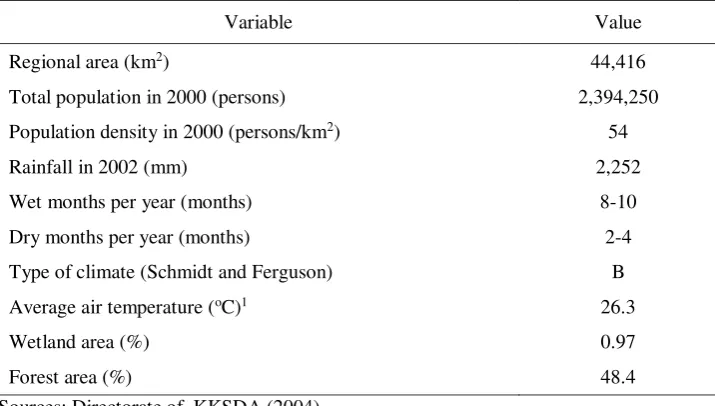
Table 1. Characteristics of Batang Hari River Basin
Variable Value
Regional area (km2) 44,416
Total population in 2000 (persons) 2,394,250
Population density in 2000 (persons/km2) 54
Rainfall in 2002 (mm) 2,252
Wet months per year (months) 8-10
Dry months per year (months) 2-4
Type of climate (Schmidt and Ferguson) B
Average air temperature (oC)1 26.3
Wetland area (%) 0.97
Forest area (%) 48.4
Sources: Directorate of KKSDA (2004)
Balai Pengelola DAS Batang Hari (2002) 1) Data in Batang Hari Regency
Batang Hari River Basin cuts across administrative areas of two provinces, namely Jambi and West Sumatra. Out of non-government’s forest areas managed by smallholders in 2002, smallholders’ forest had the largest share (9.57%) and it was much lower than that in the previous decade, i.e., 18.21 percent in 1992. During the same period, settlement area increased from 4.16 percent to 5.28 percent. On the other hand, wetland area decreased from 7.38 percent to 5.26 percent. Plantation area expanded from 38.86 percent to 47.76 percent. Overall forest area dropped from 2.74 million hectares to 2.15 million hectares.
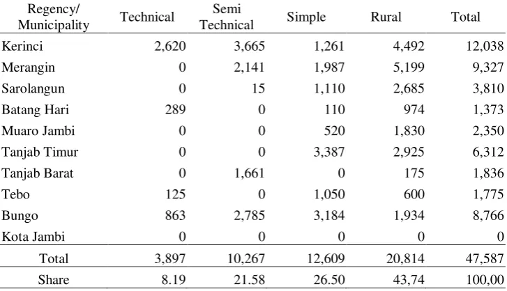
Lowland in Jambi Province based on its irrigation types are classified into technical, semi-technical, simple, and rural irrigation. Total lowland in this province was 47,587 hectares in which technical irrigated land was relatively small, i.e. 8.92 percent of total lowland area and most of them are found in Kerinci Regency (2,620 hectares). Rain-fed lowland (simple and rural irrigation) was 43.74 percent distributed in all over regencies where the largest area is found in the Regencies of Merangin (5,199 hectares) and Kerinci (4,492 hectares) such as depicted in Table 2.
Table 2. Lowland Area by Irrigation Types by Regency in Jambi Province, 2002 (hectares)
Regency/
Municipality Technical
Semi
Technical Simple Rural Total
Kerinci 2,620 3,665 1,261 4,492 12,038
Merangin 0 2,141 1,987 5,199 9,327
Sarolangun 0 15 1,110 2,685 3,810
Batang Hari 289 0 110 974 1,373
Muaro Jambi 0 0 520 1,830 2,350
Tanjab Timur 0 0 3,387 2,925 6,312
Tanjab Barat 0 1,661 0 175 1,836
Tebo 125 0 1,050 600 1,775
Bungo 863 2,785 3,184 1,934 8,766
Kota Jambi 0 0 0 0 0
Total 3,897 10,267 12,609 20,814 47,587
Share 8.19 21.58 26.50 43,74 100,00
Source: Food Crop of Agriculture Agency Jambi Province (2002)
Table 3. Lowland Area in Jambi Province, 1993-2002 (hectares)
Year Technical Semi
Technical Simple Rainfed Total
1993 2,531 9,898 26,117 18,111 56,657
1996 4,140 8,597 12,244 32,876 57,857
1999 3,617 9,694 8,204 17,400 38,915
2002 3,897 10,267 12,609 20,814 47,587
Trend (%/year) 6.00 0.41 -5.75 1.66 -1.78
Source: Directorate of KKSDA (2004)
Jratunseluna River Regime Unit (RRU)
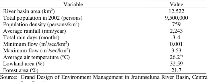
Area of JratunselunaRRU is12,521.875 km2 located on 109o 24' - 111o34' East Longitude and 06o25' - 07o 27' South Latitude. The greatest area of the river RRU is that in Grobogan Regency, namely 1,976 km2, and the smallest is that in Salatiga City, i.e., 53 Km2.
Annual rainfall of Jratunseluna RRU fluctuated over time and the average was 2,243 mm/year. The highest average rainfall was recorded at Rohwatu station, i.e., 4,839.9 mm/year, and the lowest average rainfall was at Rembang station, i.e., 1,270 mm/year. Minimum water flow of the river basin was 0.001 m3/sec/km2 and maximum water flow was 3.53 m3/sec/km2 (Table 4).
Table 4. Characteristics of Jratunseluna River Regime Unit
Variable Value
River basin area (km2) 12,522
Total population in 2002 (persons) 9,500,000
Population density (persons/km2) 759
Average rainfall (mm/year) 2,243
Total rain days (months) 3-4
Minimum flow (m3/sec/km2) 0.001
Maximum flow (m3/sec/km2) 3.53
Average air temperature (oC) 26.2*)
Lowland area (%) 32.59
Forest area (%) 21.7
Source: Grand Design of Environment Management in Jratunseluna River Basin, Central Java Province.
Jratunseluna river basin consists of several land uses, namely agricultural land including that of estate crop plantation, settlement, and forest areas. In this river basin, forest area was 21.7 percent of all areas. Lowland area was 32.59 percent (Table 4).
The dry agricultural land in the sub-river basins of Lusi and Juana was lack of water during dry season and became irrigated or rainfed during wet season. Wet and dry lowland areas are commonly found in the Regencies of Blora, Grobogan, Pati, Demak and Jepara.
Forest areas are found in Mount Muria, Ungaran, North Dieng Mountain, Sindoro, and North Rembang. Forest area consists of conserved forest, smallholders’ forest, production forest, and plantation area. An example of plantation area is rubber plantation managed by PTPN X in Merbuh, Semarang Regency, classified as production forest.
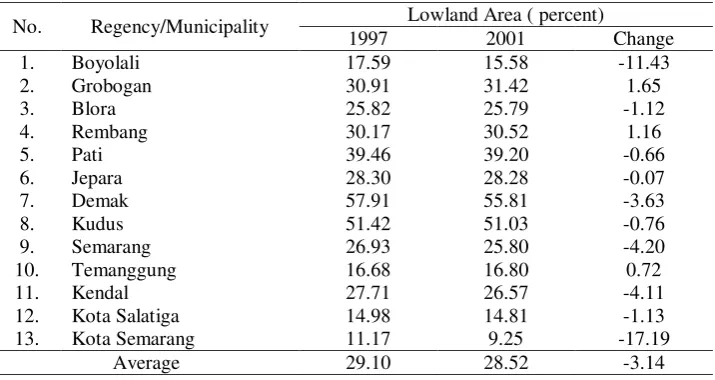
Table 5. Lowland Area in Jratunseluna River Basin by Regency, 1997 and 2001
No. Regency/Municipality Lowland Area ( percent)
1997 2001 Change
1. Boyolali 17.59 15.58 -11.43
2. Grobogan 30.91 31.42 1.65
3. Blora 25.82 25.79 -1.12
4. Rembang 30.17 30.52 1.16
5. Pati 39.46 39.20 -0.66
6. Jepara 28.30 28.28 -0.07
7. Demak 57.91 55.81 -3.63
8. Kudus 51.42 51.03 -0.76
9. Semarang 26.93 25.80 -4.20
10. Temanggung 16.68 16.80 0.72
11. Kendal 27.71 26.57 -4.11
12. Kota Salatiga 14.98 14.81 -1.13
13. Kota Semarang 11.17 9.25 -17.19
Average 29.10 28.52 -3.14
Source: Central Statistic Agency of Central Java, 1998 and 2002
Ciliwung River Basin
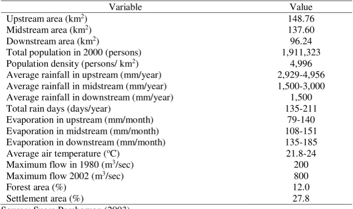
Upstream area of Ciliwung river basin is 148.76 km2, the middle is 137.60 km2, and the downstream is 96.24 km2 or total of 382.60 km2. Evaporation in the upstream ranges about 79 to 140 mm/month, in the middle is 108 to 151 mm/month, and in the lower stream is 135-185 mm/month. Maximum flow increased from 200 m3/second in 1980 to 800 m3/second in 2002 (Table 6). Geographically, Ciliwung river basin is located on 06002’ – 06048’ East Longitude and 106048’ – 107000’ South Latitude. Ciliwung River crosses Bogor regency in the upper stream. In the middle the river crosses Bogor regency, Bogor and Depok municipalities. In the lower stream the river crosses over Bogor regency and eastern part of Jakarta province, namely from Manggarai to Tanjung Priok. Even though Ciliwung river basin is relatively small compared to Batang Hari and Jratunseluna river basins, but the activities along the river basin’s parts are very intensive. Upstream of the river basin is grown with tea plantation and seasonal crops especially vegetables in which mostly sold to Jakarta. In addition, the upper stream is also a recreational area with many buildings such as houses, hotels, and villas. The midstream and the downstream of Ciliwung river basin is dense settlement.
small compared to those of Batang Hari and Jratunseluna but activities in the upstream, midstream, and downstream are quite intensive. Upstream of the river basin is cultivated with tea plantation. The farmers in Puncak also grow seasonal crops, such as vegetables, in which most of the production is sold to Jakarta. Irrigation water drained from the agricultural field flowing into the river may contain polluting chemicals. Upstream area is also a well-known recreational area where houses, hotels, and villa are established. The midstream and downstream are densely populated. Domestic and industrial wastes are drained into the river.
Table 6. Characteristics of Ciliwung River Basin
Variable Value
Upstream area (km2) 148.76
Midstream area (km2) 137.60
Downstream area (km2) 96.24
Total population in 2000 (persons) 1,911,323
Population density (persons/ km2) 4,996
Average rainfall in upstream (mm/year) 2,929-4,956
Average rainfall in midstream (mm/year) 1,500-3,000
Average rainfall in downstream (mm/year) 1,500
Total rain days (days/year) 135-211
Evaporation in upstream (mm/month) 79-140
Evaporation in midstream (mm/month) 108-151
Evaporation in downstream (mm/month) 135-185
Average air temperature (oC) 21.8-24
Maximum flow in 1980 (m3/sec) 200
Maximum flow 2002 (m3/sec) 800
Forest area (%) 12.0
Settlement area (%) 27.8
Source: Suara Pembaruan (2003).
Institutional Characteristics
Batang Hari River Basin
Many institutions, either those of government, private, and community, are involved in river basin management. In the lower stream, Batang Hari River is used for transportation. Only very slight of the river water is used for food crops farming and tapped water. Wastes of processing industries and mining activities are poured into the river.
industrial sector include those industries related directly with use of Batang Hari river; (vi) Regional Settlement and Infrastructure Service manages irrigation water use but not including water resource conservation; (vii) Tapped Water Regional Company (PDAM) processes water taken from Batang Hari river for urban consumers’ use; (viii) University of Jambi conducts study on water use, natural resources, and also forecasts on run-off, erosion, and sedimentation; (ix) Mining Service manages official mining activities and uses the upper and middle streams for transporting coal.
Agricultural sector, especially food crops subsector, uses much of irrigation water. Water macro arrangement is fully managed by Settlement and Regional Infrastructure Service (Dinas Kimpraswil), namely from primary to tertiary channels. On the other hand, Agricultural Service manages water micro arrangement, namely after the tertiary channels. Cropping patterns in the lowland adjust to existing water supply. Usually the farmers apply the cropping pattern of rice-rice-secondary crops. Severe drought took place in Jambi Province in 1991 on 867,508 hectares of lowland in which 192,311 hectares of them failed to harvest. In 1997 drought also took place in this province on 14,449 hectares and 3,109 hectares of them failed at all (Agriculture Agency Jambi Province, 2001). During normal condition, the farmers drain water to reduce flooding and during dry season close irrigation water gates to lessen water out-flow of lowland areas. It indicates that water supply from the rivers in Batang Hari river basin much fluctuates between wet and dry seasons. To avoid those risks, some farmers converted some of lowland areas into dry land for oil palm plantation.
Non-government institutions taking part in river basin management are non-government organizations (NGO) and the communities living in the area of Batang Hari river basin. One of the NGO is WARSI consisting of 13 NGO from 4 provinces, namely South Sumatra, West Sumatra, Jambi, and Bengkulu. It is a consortium of NGO focusing their activities on environment and conservation issues. WARSI in collaboration with the provincial governments of West Sumatra and Jambi was able to establish of Memorandum of Understanding on common management of Batang Hari river basin signed by the Minister of Environment and Minister of Forestry on March 11, 2003 (WARSI, 2003 and 2003a).
Jratunseluna River Regime Unit
reservoirs, dykes, irrigation networks, and others supporting facilities. Provincial Environment Management Agency establishes technical policies on environment management, such as pollution control. Forest Management Public Company rehabilitates land areas inside the forest and conserved forest sites. On the other hand, community around the forest takes part in securing the forest and they get 25 percent of forest products’ value of sale.
Some problems encountered recently are (i) degrading irrigation infrastructure and decreased water quality, (ii) lack of water-catching areas due to changing land uses, (iii) decreased environment sustainability on water resources’ functions due to improper management of upstream areas and not integrated water resource management.
Some programs implemented in developing water resources are: (i) irrigation development and management, (ii) supply and management of source water, (iii) development, management, and conservation of rivers, lakes, and other water sources, and (iv) flood control and coastal conservation maintenance.
Ciliwung River Basin
Water flowing in Ciliwung River is used for domestic and industrial purposes, especially those in midstream and downstream. Many institutions are assigned to manage water use and spatial plan of the river basin. Mining Service is authorized to set policies on ground water management, and quarry materials in the river. Regional Environment Management Agency controls pollution and rehabilitates environment quality. Local Governments establishes regional plan to manage the region such that Ciliwung River Basin is sustainable. BP DAS Citarum-Ciliwung builds up model of Ciliwung and Citarum river basins management. Tapped-Water Regional Companies processed water taken from Ciliwung River to supply drinking water of most people in urban areas. PSDA
(Natural Resources Management) Watch advocates natural resources
conservation.
Regardless of many institutions involved in managing Ciliwung River Basin, land slides in Puncak zone, polluted Ciliwung River, and frequent floods in Jakarta during wet season indicate lack of integration in its management. West Java and Jakarta Provinces have to collaborate to conserve water in Puncak zone, such as planting trees along the River, regional planning, and digging out the river in downstream area.
not flow into the pipes. A water flow of 525 m3/second has already caused flood in Jakarta. Principally, this project is not feasible to control flood and its budget is costly (Kompas, 2002)1.
In 2002, Dinas Cipta Karya recorded 1,046 villas established in Cisarua district occupying land area of 20.92 hectares. As many as 130 out of 1,046 villas, were constructed on the government’s land through illegal force and are still taking place until now. In Mega Mendung district, total villas are 669 units established over 13.38 hectares or 1.28 percent of the total land area. There area 159 villas constructed on the government’s land. There are only 36 houses established using building permits in this district and the rests have no permits (Kompas, 2003)2.
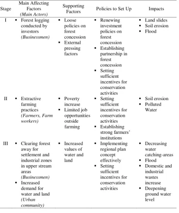
Stage of Development
Land degradation is classified into three stages with respective affecting factors, main actors, supporting factors, and policies to build up (Table 4). In the first stage, forest logging is the main cause of land degradation with businessmen as the main actors. Supporting factors at this stage are loose policies on forest concession and external pressing factors. Renewing investment policies on forest concession including partnership and incentive for forest concession is the prioritized policies to set up.
Second stage is mainly related with extractive farming activities. Providing sufficient incentives for environment conservation and building strong farmers’ organization are the main policies to consider. The third stage is related with land conversion for settlement and industrial purposes that triggers increasing demand for land and water. Effective regional planning and incentives for conservation are prioritized policies.
Such as mentioned in the Table 7, policy steps in the short and medium terms are as the entry point to improve performance of degraded natural resources management in the river basin. The policy steps consist of : (i) Improving forest logging investment. Dualistic policies, namely awarding the investors to manage forests without local community’s involvement, are necessary to be reviewed. The policies are those implemented during colonial era in which plantation enclaves were built amid surrounding poor farmers; (ii) Strengthening farmers adjacent to the forests through partnership among stakeholders. It is necessary to conduct dialogue based on equality; (iii) Providing sufficient incentives for conservation measures. It is necessary to conduct intensive assessment in the long term because of positive externalities produced by conservation measures. An incentive system is included in the dialogue and it is the dialogue’s product.
1 Kompas. 2002. Kerusakan Daerah Aliran Sungai Ciliwung agar Segera Dibenahi. 11 Juli 2002. Jakarta
Table 7. Degradation of Natural Resources in the River Basins and Policies to Implement
Factors Policies to Set Up Impacts
I Forest logging
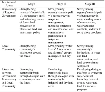
participation. The next is strengthening Water Users and farmers’ groups. Third stage, strengthening capabilities of regencies’ governments in solving conflicts, enhancing community’s institution in water conservation, and building platform of dialogue to solve conflicts (Table 8).
Table 8. Policies Support for Institutional Development in River Basin Management
Institutional
Dominant institutions in Batang Hari river basin are government’s institutions. Those institutions support uses of forest, land, and water resources but not utilize them in sustainable methods. In Jratunseluna river basin, many institutions are involved in using water more efficiently. In Ciliwung river basin, there are more institutions involving in land and water resources use due to their higher values. However, institutions in those three river basins act separately.
River basin management should be conducted in accordance with its stage of development. In the river basin of the first stage, developing partnership basis through dialogue with community around the forest is the suitable approach. Dialogue with community in irrigated and dry land areas is the approach to be done in the second stage. Dialogue platform to overcome water conflict including those of ground water and land for various purposes is the method for the third stage.
Agricultural activities, as well as forest utilization and settlement development, should be well managed to limit negative impacts in the downstream area. Too intensive agricultural activities, such as seasonal food crops including vegetables crops growing, should be controlled in order to lessen their impacts on soil erosion and water pollution. Wastes produced by domestic and industrial sectors have to be processed first before they are poured into the river flow. The polluted water will affect drinking-water processing and farm practices. Forest logging has to be restrained to control flood during wet season and draught during dry season that have negative impacts on both agriculture and non-agriculture sectors.
REFERENCES
Achet, S.H. 2000. State of the Art Watershed Management in Nepal. In K.S. Bendtsen and
K.M. Sthapit (Eds.) Watershed Development: Proceedings of Danida’s Third International Workshop on Watershed Development. Nepal-Denmark Watershed Management Project. Kathmandu, pp: 3-27.
Badan Pusat Statistik Jawa Tengah. 1998. Provinsi Jawa Tengah Dalam Angka (Central Java Province in Figures). Semarang.
Badan Pusat Statistik Jawa Tengah. 2002. Provinsi Jawa Tengah Dalam Angka (Central Java Province in Figures). Semarang.
Balai Pengelola DAS Batang Hari. 2002. Data Base dan Informasi Kegiatan Rehabilitasi Lahan dan Perhutanan Sosial di Wilayah BPDAS Batang Hari Propinsi Jambi
(Data Base and Information of Land Rehabilitation and Social Forestry in the Area of Batang Hari River Basin Managing Agency, Jambi Province). Jambi.
Dinas Pertanian. 2001. Laporan Tahunan 2001 (Annual Report in 2001). Provinsi Jambi.
Kerr, J., G.Pangare, V.L. Pangare, P.J. George, and S. Kolavalli. 1998. The Role of Watershed Projects in Developing Rainfed Agriculture in India. Prepared for the Indian Council for Agricultural Research and the World Bank. September 1998.
Suara Pembaruan. 2003. Penanggulangan Banjir di Jakarta: Perbaikan Lingkungan di Hulu dan DAS Ciliwung Lebih Penting (Flood Control Mitigation in Jakarta: Environment Improvement in Ciliwung Upstream and River Basin is More Important). Edisi 15 September 2003. www.suarapembaruan.com
WARSI. 2003. LSM Konservasi Empat Provinsi Bergabung (The Conservation Non-Government Organizations in Four Provinces Unite). Jambi, 12 Juni 2003.
WARSI. 2003a. Dua Menteri, Gubernur, dan Bupati Sumbar-Jambi, Tandatangani Nota Kesepahaman Bersama Pengelolaan DAS Batang Hari (Two Ministers, Governors, and Regents of West Sumatra-Jambi Provinces Signed the Memorandum of Understanding on Batang Hari River Basin Management). Jambi, Maret 2003.