Open Geospatial Consortium Inc.
Date: 2005-11-17
Reference number of this document: OGC 05-042r2
Version:0.1.0
Category: OpenGIS® Best Practices Paper
Editor: Arliss Whiteside
OpenGIS® web services architecture description
Copyright © 2005 Open Geospatial Consortium, Inc. All Rights Reserved. To obtain additional rights of use, visit http://www.opengeospatial.org/legal/
Warning
This document is not an OGC Standard. It is distributed for review and comment. It is subject to change without notice and may not be referred to as an OGC Standard. Recipients of this document are invited to submit, with their comments, notification of any relevant patent rights of which they are aware and to provide supporting documentation.
Document type: OpenGIS® Best Practices Paper
Document subtype: (none)
Document stage: Approved
License Agreement
Permission is hereby granted by the Open Geospatial Consortium, ("Licensor"), free of charge and subject to the terms set forth below, to any person obtaining a copy of this Intellectual Property and any associated documentation, to deal in the Intellectual Property without restriction (except as set forth below), including without limitation the rights to implement, use, copy, modify, merge, publish, distribute, and/or sublicense copies of the Intellectual Property, and to permit persons to whom the Intellectual Property is furnished to do so, provided that all copyright notices on the intellectual property are retained intact and that each person to whom the Intellectual Property is furnished agrees to the terms of this Agreement.
If you modify the Intellectual Property, all copies of the modified Intellectual Property must include, in addition to the above copyright notice, a notice that the Intellectual Property includes modifications that have not been approved or adopted by LICENSOR.
THIS LICENSE IS A COPYRIGHT LICENSE ONLY, AND DOES NOT CONVEY ANY RIGHTS UNDER ANY PATENTS THAT MAY BE IN FORCE ANYWHERE IN THE WORLD.
THE INTELLECTUAL PROPERTY IS PROVIDED "AS IS", WITHOUT WARRANTY OF ANY KIND, EXPRESS OR IMPLIED, INCLUDING BUT NOT LIMITED TO THE WARRANTIES OF MERCHANTABILITY, FITNESS FOR A PARTICULAR PURPOSE, AND NONINFRINGEMENT OF THIRD PARTY RIGHTS. THE COPYRIGHT HOLDER OR HOLDERS INCLUDED IN THIS NOTICE DO NOT WARRANT THAT THE FUNCTIONS CONTAINED IN THE INTELLECTUAL PROPERTY WILL MEET YOUR REQUIREMENTS OR THAT THE OPERATION OF THE INTELLECTUAL PROPERTY WILL BE UNINTERRUPTED OR ERROR FREE. ANY USE OF THE INTELLECTUAL PROPERTY SHALL BE MADE ENTIRELY AT THE USER’S OWN RISK. IN NO EVENT SHALL THE COPYRIGHT HOLDER OR ANY CONTRIBUTOR OF INTELLECTUAL PROPERTY RIGHTS TO THE INTELLECTUAL PROPERTY BE LIABLE FOR ANY CLAIM, OR ANY DIRECT, SPECIAL, INDIRECT OR CONSEQUENTIAL DAMAGES, OR ANY DAMAGES WHATSOEVER RESULTING FROM ANY ALLEGED INFRINGEMENT OR ANY LOSS OF USE, DATA OR PROFITS, WHETHER IN AN ACTION OF CONTRACT, NEGLIGENCE OR UNDER ANY OTHER LEGAL THEORY, ARISING OUT OF OR IN CONNECTION WITH THE IMPLEMENTATION, USE, COMMERCIALIZATION OR PERFORMANCE OF THIS INTELLECTUAL PROPERTY.
This license is effective until terminated. You may terminate it at any time by destroying the Intellectual Property together with all copies in any form. The license will also terminate if you fail to comply with any term or condition of this Agreement. Except as provided in the following sentence, no such termination of this license shall require the termination of any third party end-user sublicense to the Intellectual Property which is in force as of the date of notice of such termination. In addition, should the Intellectual Property, or the operation of the Intellectual Property, infringe, or in LICENSOR’s sole opinion be likely to infringe, any patent, copyright, trademark or other right of a third party, you agree that LICENSOR, in its sole discretion, may terminate this license without any compensation or liability to you, your licensees or any other party. You agree upon termination of any kind to destroy or cause to be destroyed the Intellectual Property together with all copies in any form, whether held by you or by any third party.
Except as contained in this notice, the name of LICENSOR or of any other holder of a copyright in all or part of the Intellectual Property shall not be used in advertising or otherwise to promote the sale, use or other dealings in this Intellectual Property without prior written authorization of LICENSOR or such copyright holder. LICENSOR is and shall at all times be the sole entity that may authorize you or any third party to use certification marks, trademarks or other special designations to indicate compliance with any LICENSOR standards or specifications.
This Agreement is governed by the laws of the Commonwealth of Massachusetts. The application to this Agreement of the United Nations Convention on Contracts for the International Sale of Goods is hereby expressly excluded. In the event any provision of this Agreement shall be deemed unenforceable, void or invalid, such provision shall be modified so as to make it valid and enforceable, and as so modified the entire Agreement shall remain in full force and effect. No decision, action or inaction by LICENSOR shall be construed to be a waiver of any rights or remedies available to it.
Contents
Pagei. Preface ...iv
ii. Document contributor contact points ...iv
iii. Revision history ...iv
iv. Future work ...iv
Foreword ...v
Introduction...vi
1 Scope ...1
2 Terms and definitions ...1
3 Abbreviated terms...3
4 OGC web services architecture overview ...4
5 Service tiers ...6
5.1 Overview...6
5.2 Information Management Services tier...7
5.3 Processing Services tier ...9
5.4 Application Services tier...11
6 Services chaining ...12
7 Service interfaces...13
8 Services communication...15
8.1 Overview...15
8.2 HTTP GET operation requests ...15
8.3 HTTP POST operation requests...15
8.4 HTTP operation responses...16
8.5 MIME types use ...16
8.6 SOAP operation requests and responses...17
9 Server implementation...17
Annex A (informative) Service trading (publish – find –bind)...18
Annex B (informative) Architecture tiers relationship to ISO 19119...20
Annex C (informative) OWS architecture relationship to RM-ODP...21
OGC 05-042r2
Figures
PageFigure 1 —Service tiers in OWS architecture...7
Figure 2 — Service trading objects ... 19
Tables
Page Table 1 — Some specific Information Management Services...8Table 2 — Some specific types of datasets...9
Table 3 — Some specific Processing Services ... 10
Table 4 — Some specific Application Services... 12
i. Preface
This document describes many aspects of the OGC web services architecture, which the OGC is currently developing. This architecture is a service-oriented architecture, with all components providing one or more services to other services or to clients. Since that architecture is being developed largely informally, broad descriptions of that architecture have not been previously written. Because that architecture is not yet completed, some aspects are not described here, and other aspects may change in the future.
Suggested additions, changes, and comments on this draft report are welcome and encouraged. Such suggestions may be submitted by email message or by making suggested changes in an edited copy of this document.
ii.
Document contributor contact points
All questions regarding this document should be directed to the editor or the contributors:
Name Organization Arliss Whiteside BAE Systems E&IS
iii. Revision
history
Date Release Editor Primary clauses modified
Description
2005-05-23 0.0.0 Arliss Whiteside All Initial draft
2005-10-17 0.0.1 Arliss Whiteside All Minor editing
2005-11-14 0.1.0 Arliss Whiteside All Minor editing as approved paper
iv. Future
work
OGC 05-042r2
Foreword
This document is related to several previous OGC documents, partially superseding those documents. Among those documents is the OGC Interoperability Program White Paper titled “Introduction to OGC Web Services” [OGC 2001]. Another such document is OGC Discussion Paper OGC 03-025 “OpenGIS Web Services Architecture”.
This document includes three informative annexes.
Introduction
OpenGIS® Discussion Paper OGC 05-042r2
OpenGIS® web services architecture description
1 Scope
This document summarizes the most significant aspects of the OGC (Open Geospatial Consortium) web services (OWS) architecture, which the OGC is currently developing. This architecture is a service-oriented architecture, with all components providing one or more services to other services or to clients. Because that architecture is not yet
completed, some aspects are not described here, and other aspects may change in the future.
NOTE This document currently contains little information on access control and accounting, because those subjects are just beginning to be explored by the OGC.
This document (currently) just describes this architecture. It does not attempt to provide all the guidance needed by an author or editor of an OGC Web Service specification.
2 Terms and definitions
For the purposes of this document, the following terms and definitions apply.
2.1
client
software component that can invoke an operation from a server
2.2
coordinate reference system
coordinate system which is related to the real world by a datum [ISO 19111]
2.3
coverage
feature that acts as a function to return values from its range for any direct position
within its spatial or spatiotemporal domain
EXAMPLE Examples include a raster image, polygon overlay, or digital elevation matrix.
2.4
feature
abstraction of real world phenomena [ISO 19101]
2.5
function
2.6
geographic information
information concerning phenomena implicitly or explicitly associated with a location relative to the Earth [ISO 19128]
2.7
interface
named set of operations that characterize the behaviour of an entity [ISO 19119]
2.8
opaque chaining aggregate service
chained services appear as a single service which handles all coordination of individual services behind the aggregate service [paraphrased from ISO 19119]
NOTE The user has no awareness that there is a set of services behind the aggregate service.
2.9
operation
specification of a transformation or query that an object may be called to execute [ISO 19119]
2.10
parameter
variable whose name and value are included in an operation request or response
2.11
a particular instance of a service [ISO 19119 edited]
2.14
service
distinct part of the functionality that is provided by an entity through interfaces [ISO 19119]
capability which a service provider entity makes available to a service user entity at the interface between those entities [ISO 19104 terms repository]
2.15
service chain
OGC 05-042r2
2.16
service metadata
metadata describing the operations and geographic information available at a server
[ISO 19128]
NOTE Most of this service metadata is specific to one server implementing a service type.
2.17
translucent chaining
workflow-managed chaining
execution of the chain is managed by a workflow service (or multiple workflow services) [paraphrased from ISO 19119]
NOTE The user’s involvement in the steps of the chain is mostly watching the chain execute the individual services that are visible to the user. The defined chain exists prior to the user executing the pattern.
2.18
transparent chaining user defined chaining
user defines and controls the order of execution of the individual services [paraphrased from ISO 19119]
NOTE Details of the services are not hidden from the user.
3 Abbreviated terms
BPEL Business Process Execution Language COTS Commercial Off The Shelf
CRS Coordinate Reference System
GML Geography Markup Language
HTTP Hypertext Transfer Protocol IETF Internet Engineering Task Force
ISO International Organization for Standardization
KVP Keyword Value Pair
MIME Multipurpose Internet Mail Extensions OGC Open Geospatial Consortium
OWS OGC Web Service, or Open Web Service SOAP Simple Object Access Protocol
SQL Structured Query Language
TBD To Be Determined
TBR To Be Reviewed
UML Unified Modeling Language URI Universal Resource Identifier
URL Uniform Resource Locator
URN Universal Resource Name
WCS Web Coverage Service
WCTS Web Coordinate Transformation Service
WFS Web Feature Service
WICS Web Image Classification Service
WMS Web Map Service
WSDL Web Services Description Language
WTS Web Terrain Service
XML Extensible Markup Language
4 OGC web services architecture overview
This Service Oriented Architecture is based on the fundamental roles of service provider and service consumer within a distributed computing system. This pattern emphasizes that desired computing can be realized by combining multiple services, for each of which only the service types (e.g., interfaces and abilities) and server data holdings (e.g.
content) need be known. It focuses component definition on providing and/or consuming a defined service. A Service Oriented Architecture also focuses on interactions between components implementing defined services, in the form of service requests, service responses, and service exceptions.
The significant properties of the OGC web services (OWS) architecture, which the OGC is currently developing, include:
a) Service components are organized into multiple tiers.
1) All components provide services, to clients and/or other components, and each component is usually called a service (with multiple implementations) or a server (each implementation).
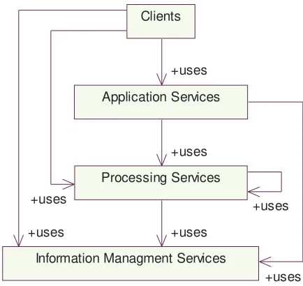
2) Services (or components) are loosely arranged in four tiers, from Clients to Application Services to Processing Services to Information Management Services, but un-needed tiers can be bypassed.
3) Services can use other services within the same tier, and this is common in the Processing Services tier.
4) Each tier of services has a general purpose, which is independent of geographic data and services.
OGC 05-042r2
6) Servers can operate on (tightly bound) data stored in that server and/or on (loosely bound) data retrieved from another server.
b) Services use is often chained.
1) Services can be chained with other services and often are chained, either
transparently (defined and controlled by the client), translucently (predefined but visible to the client), and opaquely (predefined and not visible to client), see Subclause 7.3.5 of [OGC 02-006 and ISO 19119]
2) Services are defined to support defining and executing chains of services.
3) Some service interfaces support server storage of operation results until requested by the next service in a chain.
c) Service interfaces use open standards and are relatively simple.
1) All services support open standard interfaces from their clients, often OGC-specified service interfaces.
2) OGC web service interfaces are coarse-grained, providing only a few static operations per service.
3) Service operations are normally stateless, not requiring servers to retain interface state between operations.
4) One server can implement multiple service interfaces whenever useful. 5) Service interfaces share common parts whenever practical.
6) Service interfaces can have multiple specified levels of functional compliance, and multiple specialized subset and/or superset profiles.
7) Standard XML-based data encoding languages are specified for use in data transfers.
8) Geographic data and service concepts are closely based on the ISO 191XX series of standards.
9) Standard specifications are used for defining and referencing well-known coordinate reference systems (CRSs).
d) Services communication uses open Internet standards.
1) Communication between components uses standard World Wide Web (WWW) protocols, namely HTTP GET, HTTP POST, and SOAP.
2) Specific server operations are addressed using Uniform Resource Locators (URLs).
3) Multipurpose Internet Mail Extensions (MIME) types are used to identify data transfer formats.
e) Server and client implementations are not constrained.
1) Services are implemented by software executing on general purpose computers connected to the Internet. The architecture is hardware and software vendor neutral.
2) The same and cooperating services can be implemented by servers that are owned and operated by independent organizations.
3) Many services are implemented by standards-based Commercial Off The Shelf (COTS) software.
4) All services are self-describing, supporting dynamic (just-in-time) connection binding of services supporting publish-find-bind.
5 Service tiers
5.1 Overview
Except for clients, all OWS architecture components provide services, to clients and/or to other components. Each such component is usually called a service when multiple implementations are expected, and each implementation is called a server (or service instance). These components are thus usually called services or servers in this document. Clients are software packages that provide access to a human user, or operate as agents on behalf of other software. Software that provides access to a human user can be thin (e.g., a web browser), thick (a large application), or “chubby” (in between).
All services (or components) are loosely organized in four tiers, as shown in Figure 1. This organization is loose in that clients and services can bypass un-needed tiers, as indicated by some arrows. Services can use other services within the same tier, and this is common especially in the Processing Services tier. Also, some services perform functions of more than one tier, when those functions are often used together and combined implementation is more efficient. Assignment of such combined services to tiers is somewhat arbitrary.
OGC 05-042r2
Processing Services Clients
Information Managment Services Application Services
+uses +uses
+uses
+uses +uses
+uses +uses
Figure 1 —Service tiers in OWS architecture
This OWS architecture is designed for use where data is important and often voluminous. Servers can operate on (tightly bound) data stored in that server and/or on (loosely bound) data retrieved from another server. Most data is stored by the servers in the Information Management Services tier, but some data (can be and often) is stored in other services and servers.
Each tier of services has a general purpose, as indicated by the names in Figure 1. That tier name is independent of geographic data and services, since some tier services are not specific to geographic data or services. Each tier of services includes multiple specific types of services, many of which are tailored to geographic data and services. Some of the services included in each tier are discussed in the following subclauses.
5.2 Information Management Services tier
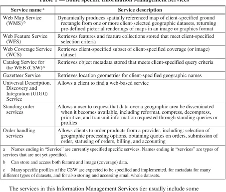
Table 1 — Some specific Information Management Services
Service name a Service description
Web Map Service
(WMS) b Dynamically produces spatially referenced map of client-specified ground rectangle from one or more client-selected geographic datasets, returning
pre-defined pictorial renderings of maps in an image or graphics format Web Feature Service
(WFS)
Retrieves features and feature collections stored that meet client-specified selection criteria
Web Coverage Service (WCS)
Retrieves client-specified subset of client-specified coverage (or image) dataset
Catalog Service for
the WEB (CSW) c Retrieves object metadata stored that meets client-specified query criteria
Gazetteer Service Retrieves location geometries for client-specified geographic names Universal Description,
Discovery and Integration (UDDI) Service
Allows a client to find a web-based service
Standing order services
Allows a user to request that data over a geographic area be disseminated when it becomes available, including reformat, compress, decompress, prioritize, and transmit information requested through standing queries or profiles
Order handling services
Allows clients to order products from a provider, including: selection of geographic processing options, obtaining quotes on orders, submission of order, statusing of orders, billing, and accounting
a Names ending in “Service” are currently specified specific services. Names ending in “services” are types of services that are not yet specified.
b Can store and access both feature and image (coverage) data.
c Many specific profiles of the CSW are expected to be specified and implemented, for metadata for many different types of datasets, and for also storing and accessing small whole datasets.
The services in this Information Management Services tier usually include some processing of the data retrieved. For example, WMS, WCS, and WFS can perform coordinate transformation and format conversion.
OGC 05-042r2
Table 2 — Some specific types of datasets
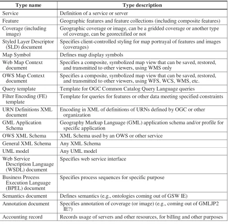
Type name Type description
Service Definition of a service or server
Feature Geographic features and feature collections (including composite features) Coverage (including
image)
Geographic coverage or image, can be a gridded coverage or another type of coverage, can be georectified or not
Styled Layer Descriptor (SLD) document
Specifies client-controlled styling for map portrayal of features and images (coverages)
Map Symbol Defines map display symbols Web Map Context
document
Specifies a composite, symbolized map view that can be saved, restored, and transmitted to other viewers, using WMS only
OWS Map Context document
Specifies a composite, symbolized map view that can be saved, restored, and transmitted to other viewers, using WFS, WCS, WMS, etc. Query template Template for OGC Common Catalog Query Language queries Filter Encoding (FE)
template
Template for queries for features or other data meeting specified constraints
URN Definitions XML document
Encoding in XML of definitions of URNs defined by OGC or other organization
GML Application Schema
Geography Markup Language (GML) application schema and/or profile for specific application
OWS XML Schema XML Schema used by an OWS or other service General XML Schema Any XML Schema
UML model Any UML model
Specifies process sequences for specific purpose
Semantics document Defines semantics (e.g., ontologies coming out of GSW IE)
Annotation document Specifies annotation of coverage (or image) (e.g., coming out of GMLJP2 IE?)
Accounting record Records usage of servers and other resources, for billing and other purposes
5.3 Processing Services tier
Table 3 — Some specific Processing Services
Service name a Service description
SLD Web Map Service
(WMS) b Dynamically produces spatially referenced maps from geographic feature and/or coverage data, returning client-specified pictorial renderings of
maps in an image format (not actual feature data or coverage data) Web Terrain Service
(WTS) b Dynamically produces client-specified perspective views from geographic feature and/or coverage data, returning client-specified pictorial
renderings of data in an image or graphics format Web 3D Service
(W3DS)
Dynamically produces client-specified perspective views from geographic feature data, returning perspectives of feature data in a graphical format Web Coordinate
Transformation Service (WCTS) b
Transforms the coordinates of feature or coverage data from one coordinate reference system (CRS) to another, including “transformations”,
“conversions”, rectification, and orthorectification Web Image
Classification Service (WICS)
Performs classification of digital images, using client-selected supervised or unsupervised image classification method
Feature Portrayal Service (FPS)
Dynamically produces client-specified pictorial renderings in an image or graphics format of features and feature collections usually dynamically retrieved from a Web Feature Server (WFS)
Coverage Portrayal Service (CPS)
Dynamically produces client-specified pictorial renderings in an image or graphics format of a coverage subset dynamically retrieved from a Web Coverage Service (WCS)
Geoparser Service Service to scan text documents for location-based references, such as a place names, addresses, postal codes, etc., for passage to a geocoding service.
Geocoder Service Service to augment location-based text references with position coordinates Geolinking Service
(GLS) b Service that links geospatial data
Geolinked Data Access Service (GDAS)
Service that uses linked geospatial data
Geographic data extraction services
Services supporting extraction of feature and terrain information from images
Dimension measure-ment services
Services that compute dimensions of objects visible in an image or other geospatial data
Route determination services
Determine optimal path between two specified points based on input parameters and properties contained in a Feature Collection; may also determine distance between points and/or time to follow path
Proximity analysis services
Given a position or geographic feature, finds all objects with a specified set of properties that are located within a user-specified distance of the position or feature.
Change detection services
Services to find differences between two data sets that represent the same geographical area at different times
Data alignment services Service that adjusts sensor geometry models to improve the match of a coverage (or image) with other coverages and/or known ground positions Feature generalization
services
OGC 05-042r2
Service name a Service description
Coverage general-ization services
Service that reduces spatial variation in a coverage to counteract the undesirable effects of scale reduction
Format conversion services
Service that converts data from one format to another, including data compression and decompression
Semantic translation
services a Service that converts data from one set of semantics to another
a Names ending in “Service” are currently specified specific services. Names ending in “services” are types of services that are not yet specified.
b Can process both feature and image (coverage) data.
5.4 Application Services tier
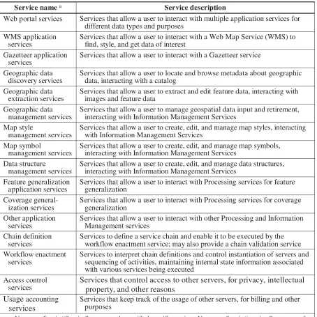
Table 4 — Some specific Application Services
Service name a Service description
Web portal services Services that allow a user to interact with multiple application services for different data types and purposes
WMS application services
Services that allow a user to interact with a Web Map Service (WMS) to find, style, and get data of interest
Gazetteer application services
Services that allow a user to interact with a Gazetteer service
Geographic data discovery services
Services that allow a user to locate and browse metadata about geographic data, interacting with a catalog
Geographic data
extraction services Services that allow a user to extract and edit feature data, interacting with images and feature data Geographic data
management services
Services that allow a user to manage geospatial data input and retirement, interacting with Information Management Services
Map style
management services
Services that allow a user to create, edit, and manage map styles, interacting with Information Management Services
Map symbol
management services Services that allow a user to create, edit, and manage map symbols, interacting with Information Management Services Data structure
management services
Services that allow a user to create, edit, and manage data structures, interacting with Information Management Services
Feature generalization
application services Services that allow a user to interact with Processing services for feature generalization Coverage
general-ization services
Services that allow a user to interact with Processing services for coverage generalization
Other application services
Services that allow a user to interact with other Processing and Information Management services
Chain definition services
Services to define a service chain and enable it to be executed by the workflow enactment service; may also provide a chain validation service Workflow enactment
services
Services to interpret chain definitions and control instantiation of servers and sequencing of activities, maintaining internal state information associated with various services being executed
Access control services
Services that control access to other servers, for privacy, intellectual property, and other reasons
Usage accounting
services
Services that keep track of the usage of other servers, for billing and other purposes
a Names ending in “Service” are currently specified specific services. Names ending in “services” are types of services that are not yet specified.
6 Services chaining
In many cases, multiple services must be used together to perform a useful function. The OWS architecture thus supports “chaining” together of multiple servers, and such
OGC 05-042r2
(predefined and not visible to client), see Subclause 7.3.5 of [OGC 02-006 and ISO 19119].
To facilitate service chaining, some services are defined to support defining and executing chains of services. Also, some Processing Service interfaces are designed to support retrieving the data to be processed from another service, which can be an
Information Management Service or another Processing Service. To allow more efficient execution of server chains, some service interfaces support server storage of operation results until requested by next service in a chain.
7 Service interfaces
The basic components of a service oriented architecture are services. There are many definitions of “service”, from the abstract to the concrete and practical. One definition is “useful/meaningful combination of operational interfaces and accessible content”. This definition adds “content” to the ISO/OGC definitions:
a) Service: distinct part of the functionality that is provided by an entity through interfaces.
b) Interface: named set of operations that characterize the behavior of an entity.
c) Operation: specification of a transformation or query that an object may be called to execute. It has a name and lists of input and output parameters.
OGC web service interfaces use open standards and are relatively simple. All services support open standard interfaces from their clients, often OGC-specified service
interfaces. In addition to being well-specified and interoperable tested, the OGC-specified service interfaces are coarse-grained, providing only a few static operations per service. For many services, only three service operations are specified.
NOTE 1 OGC web service interfaces are not fine-grained object-oriented, providing tens of operations per service to be implemented and exercised, with some interface objects being dynamically created and destroyed.
In most cases, one service listed in Clause 5 includes just one interface. However, it is possible for one service to include more than one identified interface, normally limited to a few such interfaces. Also, one server can implement multiple interfaces whenever useful, without those interfaces being combined in a specified service.
NOTE 2 One service interface is not required to support all the abilities of one server. For example, some WCS, WMS, and WFS data servers are expected to also implement CSW service interfaces cataloging the datasets available from that server.
The OGC web service interfaces are usually stateless, so session information is not passed between a client and server. Clients (or Application Services) retain any needed interface state between operations.
The OGC web service interfaces share common parts whenever practical, allowing those parts to be specified and implemented only once. For example, all OWSs have a
mandatory GetCapabilities operation to retrieve server metadata. That server metadata includes four required sections, with the contents and format of three sections common to all services, and part of the fourth section common to most services. In addition, many service interfaces have multiple specified levels of functional compliance, or multiple specialized subset and/or superset profiles.
NOTE 4 The interface parts are NOT separately and independently specified and developed. When more parts are common among interfaces, less work is needed to implement services and define new ones. In addition to the GetCapabilities operation, all OWSs have one mandatory operation to get a data subset, and most have one optional operation to get the description of a dataset or object. Interface compliance levels and profiles inherently share interface parts wherever practical.
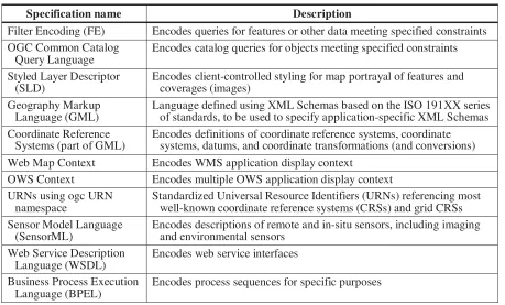
Standard XML-based data encoding formats and languages are used in many server-to-client and server-to-client-to-server data transfers. The formats and languages specified include (but are not limited to) those listed in Table 5. In these formats and languages and
elsewhere, the geographic data and service concepts are closely based on the ISO 191XX series of standards.
NOTE 5 The ISO 191XX data and service concepts were developed by international groups of experts, so are carefully formulated and are being widely used. The concepts or semantics used by different services are not independently developed and specified.
Table 5 — Some standardized encoding formats and languages
Specification name Description
Filter Encoding (FE) Encodes queries for features or other data meeting specified constraints OGC Common Catalog
Query Language
Encodes catalog queries for objects meeting specified constraints
Styled Layer Descriptor (SLD)
Encodes client-controlled styling for map portrayal of features and coverages (images)
Geography Markup Language (GML)
Language defined using XML Schemas based on the ISO 191XX series of standards, to be used to specify application-specific XML Schemas Coordinate Reference
Systems (part of GML)
Encodes definitions of coordinate reference systems, coordinate systems, datums, and coordinate transformations (and conversions) Web Map Context Encodes WMS application display context
OWS Context Encodes multiple OWS application display context URNs using ogc URN
namespace
Standardized Universal Resource Identifiers (URNs) referencing most well-known coordinate reference systems (CRSs) and grid CRSs Sensor Model Language
(SensorML)
Encodes descriptions of remote and in-situ sensors, including imaging and environmental sensors
OGC 05-042r2
8 Services communication
8.1 Overview
Communication between clients and services, and between services, uses only open non-proprietary Internet standards. That is, the OWS architecture uses the Internet or
equivalent as its distributed computing platform (DCP). More specifically,
communication between components uses standard World Wide Web (WWW) protocols, namely HTTP GET, HTTP POST, and Simple Object Access Protocol (SOAP). Specific operations of specific servers are addressed using Uniform Resource Locators (URLs). Multipurpose Internet Mail Extensions (MIME) types are used to identify data transfer formats. The data transferred is often encoded using the Extensible Markup Language (XML), with the contents and format carefully specified using XML Schemas.
NOTE Communication between components does not use CORBA, DCOM, .NET, or SQL. However, those protocols can be used within the implementation of a server.
8.2 HTTP GET operation requests
In many cases, a request to perform an operation by a service is transferred as a
Hypertext Transfer Protocol (HTTP) GET message. That GET message is addressed to a HTTP Uniform Resource Locator (URL), where that URL locates a specific operation of a specific server. A URL for a HTTP GET request is in fact only a URL prefix, to which additional parameters are appended to construct a valid operation request. The prefix defines the network address to which operation request messages are sent, and may also identify a configuration of that server.
A query is appended to the URL prefix to form a complete request message. Each OWS operation request has mandatory and usually optional request parameters. Each parameter has a defined name, and has multiple allowed values. To formulate the query part of the URL, the mandatory request parameters, and any desired optional parameters, are
appended as name/value pairs in the form "name=value&" (parameter name, equals sign, parameter value, ampersand). In the OGC, this parameter encoding is often referred to as keyword value pair (KVP) encoding.
8.3 HTTP POST operation requests
Less frequently, a request to perform an operation by a service is transferred as a
Hypertext Transfer Protocol (HTTP) POST message. That POST message is addressed to a (possibly different) HTTP Uniform Resource Locator (URL), where that URL locates a specific operation of a specific server. A URL for a HTTP POST request is a complete URL (not merely a prefix as in the HTTP GET case).
8.4 HTTP operation responses
After receiving an operation request, a server replies with a response message
corresponding exactly to the request, or sends an exception report if unable to respond correctly. Responses to operation requests are the same whether the request is transferred by HTTP GET or POST. In most cases, the operation response is encoded in XML, using XML Schemas to specify the correct response contents and format. These statements apply to both normal and exception operation responses, which are separately specified for each OWS service.
All XML Schemas used contain documentation of the meaning of each specified element, attribute, and type. All of these documentation elements are considered normative, unless labeled “informative”. Almost all of the concrete XML elements defined in these OWS Schemas can be used without separate XML Schemas, whenever no content extensions or restrictions are needed. An additional XML Schema is used whenever element contents extension is required, and should be used in some other cases to specify needed
restrictions.
NOTE XML documents are not required to be validated against their respective schemas for normal service use. However, XML parsing and validation should follow normal XML syntax rules, for example regarding XML Namespaces.
A server may send an HTTP Redirect message (using HTTP response codes as defined in [IETF RFC 2616]) to an absolute URL that is different from the valid request URL that was sent by the client. HTTP Redirect causes the client to issue a new HTTP request for the new URL. Several redirects could in theory occur. Practically speaking, the redirect sequence ends when the server responds with an operation response. The final response shall be an OWS operation response that corresponds exactly to the original operation request, or an exception report.
8.5 MIME types use
Response messages are accompanied by the appropriate Multipurpose Internet Mail Extensions (MIME) type for that message. A list of MIME types in common use on the internet is maintained by the Internet Assigned Numbers Authority [IANA]. Servers can support parameterized MIME types, and this is common to more completely identify the specific format. In addition to parameterized MIME types, servers usually offer the basic un-parameterized version of the format, for clients that do no understand the
parameterized MIME type.
OGC 05-042r2
8.6 SOAP operation requests and responses
In some cases, a request to perform a specific operation by a specific server can be transferred in a Simple Object Access Protocol (SOAP) operation request message. That SOAP request message is addressed to a HTTP Uniform Resource Locator (URL), where that URL locates a specific operation of a specific server (TBR). In this case, the
operation request parameters are encoded in XML just like they can be for HTTP POST. When SOAP is used, the response from that operation is transferred in a SOAP operation reply message, and is XML encoded just like responses to HTTP POST requests.
9 Server implementation
Servers and client implementations are not constrained except for supporting the specified service interfaces. Each can be implemented by software executing on any general purpose computer connected to the Internet or equivalent. The architecture is hardware and software vendor neutral. The same and cooperating services can be implemented by servers that are owned and operated by independent organizations.
NOTE Cooperating servers and clients need not be owned and operated by one organization or by formally cooperating organizations.
All OWS services and clients are implemented by available standards-based Commercial Off The Shelf (COTS) software. This commercial software can sometimes be used without requiring major software development, or can be adapted to specific needs with limited software development.
Annex A
(informative)
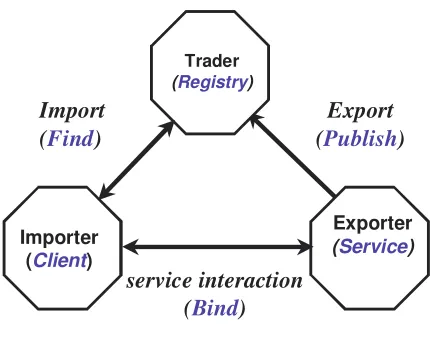
Service trading (publish – find –bind)
Service trading supports the offering and discovery of interfaces which provide services of particular types. A trader implementation records service offers and matches requests for advertised services. Publishing a capability or offering a service is called “export”. Matching a service request against published offers or discovering services is called “import”. This can also be described in an equivalent manner as the “Publish – Find – Bind” (PFB) pattern of service interaction. The fundamental roles are:
a) Trader (Registry) - registers service offers from exporter objects and returns service offers to importer objects upon request according to some criteria.
b) Exporter (Service) - registers service offers with the trader object
c) Importer (Client) - obtains service offers, satisfying some criteria, from the trader object.
NOTE In the OWS architecture, a Registry can be implemented using the Catalog Service for the WEB (CSW) service interface.
The ODP Trading function is elaborated in document [ISO/IEC 13235-1] and refined somewhat in the OMG Trading specification [TBD], which is technically aligned with the computational view of the ODP trading function. Most importantly, a trader supports dynamic (i.e. run-time) binding between service providers and requesters, since sites and applications are frequently changing in large distributed systems. The fundamental roles and interactions are depicted in Figure 2.1 The equivalent PFB terminology is shown as well (blue italic text). A traderregisters service offers from exporter objects and returns service offers upon request to importer objects according to some criteria.
1Many readers will recognize Figure 2: many of the recent web services white papers include
OGC 05-042r2
Trader
(Registry)
Importer (Client)
Exporter
(Service)
Export
(Publish)
service interaction (Bind) Import
(Find)
Figure 2 — Service trading objects
A Trader plays the role of “matchmaker” in a service-based architecture. The interaction pattern is:
a) To publish a service offer, an Exporter gives a Trader a description of a server, including a description of the interface at which that service instance is available. b) To find suitable server offers, an Importer asks a Trader for a server having certain
characteristics. The trader checks the previously registered descriptions of servers and responds to the importer with the information required to bind with a service instance. Preferences may be applied to the set of offers matched according to service type, constraint expressions, and various policies. Use of the preferences can determine the order used to return matched offers to the importer.
Annex B
(informative)
Architecture tiers relationship to ISO 19119
The four tiers of the OWS architecture are loosely related to the geographic services categories specified in Subclause 8.3 of ISO 19119 Geographic information — Services (copied in OGC Abstract Specification Topic 12). This relationship is:
a) The Application Services and the Clients together provide the “human interaction services” described in Subclause 8.3.2.
b) The Processing Services provide the “processing services” described in Subclause 8.3.5. It would be possible to divide these services into the “spatial”, “thematic”, “temporal” and “metadata” categories described in Subclause 8.3.5.
c) The Information Management Services provide the “model/information management services” described in Subclause 8.3.3.
In this description of the OWS architecture, the storage of datasets is not separated from catalogues or registries that store and search metadata, because they are not separated in ISO 19119. Also, these services are not separated because that distinction is frequently fuzzy. Furthermore, one server can implement a dataset storage and retrieval interface plus a catalogue interface for storing and searching the metadata for those datasets. Some services perform functions of more than one tier, when those functions are usually used together and combined implementation is more efficient. Assignment of such combined services to tiers is somewhat arbitrary. For example, all services in the
OGC 05-042r2
Annex C
(informative)
OWS architecture relationship to RM-ODP
This architecture description is organized for ease-of-understanding, not according to the five viewpoints specified in the Reference Model for Open Distributed Processing (RM-ODP) [ISO 10746]. The concept of distributing computing functions across a network in a dynamic fashion has been addressed by this RM-ODP, which is a conceptual
framework for such systems, and implementation patterns or rules. Five standard viewpoints are defined; these viewpoints address different aspects of the system and enable the ‘separation of concerns’:
a) Enterprise viewpoint: articulates a “business model” that should be understandable by all stakeholders; focuses on purpose, operational objectives, policies, enterprise objects, etc.
b) Information viewpoint: focuses on information content and system behavior (i.e. data models, semantics, schemas)
c) Computational viewpoint: captures component and interface details without regard to distribution
d) Engineering viewpoint: exposes the distributed nature of the system and provides standard definitions to describe engineering constraints
e) Technology viewpoint: describes where to apply the technologies/products of choice and allows for conformance testing against the architectural specification
This architecture description currently says little directly about the Enterprise and
Information viewpoints. We think this OWS architecture is applicable to a broad range of purposes, using a broad range of information. However, Tables 1 and 2 suggest some of the types of information handled.
Bibliography
[1] CGI, The Common Gateway Interface, National Center for Supercomputing Applications, http://hoohoo.ncsa.uiuc.edu/cgi/
[2] IETF RFC 2045 (November 1996), Multipurpose Internet Mail Extensions (MIME) Part One: Format of Internet Message Bodies, Freed, N. and Borenstein N., eds., http://www.ietf.org/rfc/rfc2045.txt
[3] IETF RFC 2141 (May 1997), URN Syntax, R. Moats http://www.ietf.org/rfc/rfc2141.txt
[4] IETF RFC 2396 (August 1998), Uniform Resource Identifiers (URI): Generic Syntax, Berners-Lee, T., Fielding, N., and Masinter, L., eds.,
http://www.ietf.org/rfc/rfc2396.txt
[5] IETF RFC 2616 (June 1999), Hypertext Transfer Protocol – HTTP/1.1, Gettys, J., Mogul, J., Frystyk, H., Masinter, L., Leach, P., and Berners-Lee, T., eds.,
http://www.ietf.org/rfc/rfc2616.txt
[6] IANA, Internet Assigned Numbers Authority, MIME Media Types,
http://www.iana.org/assignments/media-types/
[7] ISO/IEC 10746-1:1998, Reference Model for Open Distributed Processing (RM-ODP)
[8] OGC 2001, Introduction to OGC Web Services
[9] OGC 02-006, OpenGIS Abstract Specification Topic 12: OpenGIS Service Architecture
[10] OGC 03-025, OpenGIS Web Services Architecture
[11] OGC 05-008, OGC Web Services Common Specification, version 1.0.0 [12] OGC 05-010, URNs of definitions in ogc namespace
[13] SIDP (Spatial Interoperability Demonstration Project) 2004-2005, Notional Architecture, http://www.sidp.com.au/
[14] W3C Recommendation 04 February 2004, Extensible Markup Language (XML) 1.0 (Third Edition), http://www.w3.org/TR/REC-xml
[15] W3C Recommendation 2 May 2001: XML Schema Part 0: Primer, http://www.w3.org/TR/2001/REC-xmlschema-0-20010502/
[16] W3C Recommendation 2 May 2001: XML Schema Part 1: Structures, http://www.w3.org/TR/2001/REC-xmlschema-1-20010502/