Zhenjiang Shen
Miaoyi Li
Editors
Big Data Support
of Urban
Planning and
Management
Series editors
Editors
Big Data Support of Urban
Planning and Management
ISSN 1867-2434 ISSN 1867-2442 (electronic) Advances in Geographic Information Science
ISBN 978-3-319-51928-9 ISBN 978-3-319-51929-6 (eBook) DOI 10.1007/978-3-319-51929-6
Library of Congress Control Number: 2017952939 © Springer International Publishing AG 2018
This work is subject to copyright. All rights are reserved by the Publisher, whether the whole or part of the material is concerned, specifically the rights of translation, reprinting, reuse of illustrations, recitation, broadcasting, reproduction on microfilms or in any other physical way, and transmission or information storage and retrieval, electronic adaptation, computer software, or by similar or dissimilar methodology now known or hereafter developed.
The use of general descriptive names, registered names, trademarks, service marks, etc. in this publication does not imply, even in the absence of a specific statement, that such names are exempt from the relevant protective laws and regulations and therefore free for general use.
The publisher, the authors and the editors are safe to assume that the advice and information in this book are believed to be true and accurate at the date of publication. Neither the publisher nor the authors or the editors give a warranty, express or implied, with respect to the material contained herein or for any errors or omissions that may have been made. The publisher remains neutral with regard to jurisdictional claims in published maps and institutional affiliations.
Printed on acid-free paper
This Springer imprint is published by Springer Nature The registered company is Springer International Publishing AG
The registered company address is: Gewerbestrasse 11, 6330 Cham, Switzerland Zhenjiang Shen
Joint International FZUKU Lab SPSD Fuzhou University
Fuzhou City China
Kanazawa University Kanazawa City Japan
Miaoyi Li
Joint International FZUKU Lab SPSD Fuzhou University
v Urban planning and governance innovation have been topics of the latest annual conferences conducted by Urban Planning Society of China (UPSC), which best represented the spirit of UPSC in terms of transformation of urban planning system in China from conventional professional planning and design to highly complex, multidisciplinary policy processes. In China, demand-oriented approach in plan-ning could not reveal the true direction of urbanization and fails to respond to the economic challenges. We should adopt a solution-oriented approach to urban dis-eases after the rapid urbanization process. Many Chinese planners and decision makers now argued that a better understanding of what happens to Chinese cities is vital to planning and design for existing cities and new towns. To say simply that a reasonable data analysis should be enhanced to conventional process of urban plan-ning and design, comprehensive evaluation of alternative plans based on urban simulation should be conducted for decision making and regular diagnosis of status quo for city development should be made prior to any revision of statutory plans. Hence, geospatial analysis and simulation techniques become very hot topics within the field of urban planning in China recently.
In China, smart city construction is growing rapidly under the implementation of the scheme for promotion of smart city in China. For example, in mobile devices installed with social network system (SNS), GPS function can be used as data source of big data; other data sources such as traffic card, cellphones, and so on are very often to be seen nowadays in Chinese cities. Most of chapters in this book are related to mobile devices and human mobility. There are many kinds of big data that can be possibly used in the planning field, such as SNS, Points of Interest (POI), Taxi GPS tracking, and cellular signal for urban structure analysis from views of human mobility. In addition, real time big data collected from smart infrastructure, such as transportation monitoring system, environment monitoring system, and security system can be stored in database and developed as Cyber infrastructure that is a cloud-based urban management platform for urban management, as presented in this book.
There is a big demand for big data analysis in China. In the field of planning, many our colleagues, particularly young generation, are eager to handle big data for urban planning and design, including those in planning research institutes, faculties, and students in universities. It is very exciting that symposiums and conferences were organized for sharing planning experience on big data application for new approaches of urban planning in the recent years. In 2014, we hosted the first sym-posium of smart city and big data application in UPSC Annual Conference in Haikou city, and after that many events and forums were organized on this topic. We also invited Prof. Zhenjiang SHEN from Japan and others to give lectures on the topic. As promoted by our Society, more planners and researchers in China have shown strong interests in big data application, and best practices and case studies have been published in journals and books.
Thanks to many researchers and planners in China who have contributed to this book; it is my great honor to present this first book introducing Chinese case studies of big data application in planning. I sincerely hope that the audience will enjoy reading this book and take it as a reference for understanding big data analytics. This publication, which shares experiences on smart city and big data application, will of immense use to friends and colleagues who concern with China.
vii It is the first book to introduce case studies of big data application for planning practices in China. This book, consisting 22 chapters, elaborates diverse planning support efforts on big data analysis in many Chinese cities, which primarily intro-duced how geospatial analysis using big data could be conducted and how big data will help planners and decision makers for understanding what are happening in their cities.
Using big data for spatiotemporal analysis of human mobility is a new challenge for easing the urban diseases caused by rapid urbanization in China. The Chinese Society for Urban Studies has newly launched the Urban Big Data Commission on 15 November 2016. Most of the contributors in this book are members of this com-munity. I am happy to see that all authors explore the new potential of urban-rural planning and management using data-driven approaches from practical perspectives in this book, which is a multidisciplinary cooperation related to smart city construc-tion in China. As menconstruc-tioned above, a collecconstruc-tion of up-to-date case studies using big data has been presented, and contributors draw a picture of the current research status of big data application in urban China.
The applications of geospatial analysis using big data in this book are described as several essential aspects of elaborating urban structure: social network system and human behaviors, POI mapping and urban space recognition, mobile device data, and urban form reflecting human activities, all these works are related to visu-alizing conflicts between land use and transportation in China. Authors of this book proved that big data collected from mobile devices and social network are useful for analyzing human mobility, obtaining urban space recognition, and exploring spatio-temporal urban structure. Exploring urban structure after the rapid urbanization pro-cess in China is concerned with possible solutions of urban diseases in Chinese cities. The case studies in this book will explain how big data changes the percep-tion of planners and researchers in their practices.
infrastructure construction. IoT sensors for collecting mobile device data and sys-tem platform that uses real-time traffic monitoring data are opening a new era for urban management. I expect there would be more and more new big data sources from smart city construction, hereby promoting urban studies to a new stage.
ix Rapid urbanization has not only modernized the Chinese lifestyle, but has also led to significant challenges, including, increased energy consumption, pollution and traffic congestion, to name a few.
With the development of information-sensing technologies and large-scale com-puting infrastructures that have generated huge amounts of urban spatial big data of mobility, environmental quality, and energy consumption, the relationship between these issues have become more easily identifiable. This identification creates a call for smarter, more environmentally conscious urban planning decisions.
One possible answer to the problems facing a rapidly urbanized China is the “smart city concept.” This approach, relying on the huge volume of data being absorbed by countless inconspicuous sensors spread across the subject city, pro-vides hints on the direction that should be taken by modern urban planners. The implementation of the smart city concept is predicated on the ubiquity of smart technologies, namely, cellphones and other portable devices comprising the Internet of Things (IoT). These technologies augment the volume, velocity, and variety of the information that is accessible to those tasked with urban planning. In other words, there is an inverse relationship between the size of technologies and the quality and quantity of information that can be gathered. Chips are capable of gath-ering data on environmental quality, urban mobility, and energy consumption, thereby informing future research into the human lifestyle patterns.
I wish for this book to be a platform upon which researchers might share their thoughts on computational and data-driven techniques as they relate to urban plan-ning and design in future China. I would urge the reader to make use of the accounts held within its pages to enter the conversation on the applications and limitations of big data in China’s push towards smart and sustainable urbanization.
xi Prof. Yanwei CHAI, Peking University.
Dr. Jian CAO, Digital Intelligence System Technology Co., Ltd. Prof. Anrong DANG, Tsinghua University.
Prof. Wenqi LIN, Tsinghua University. Prof. Yungang LIU, SUN Yat-sen University. Assoc. Prof. Ying LONG, Tsinghua University.
Dr. Mingrui MAO, Beijing City Quadrant Technology Co., Ltd. Prof. De WANG, Tongji University.
xiii We would like to express our deep appreciation to all the authors for their outstand-ing contribution to this book, to series editors of “Advances in Geographic Information Science” Prof. Suzana Dragicevic and Prof. Shivanand Balram of Simon Fraser University for their kind invitation and encouragement, and to Dr. Ron Doering and Dr. Susan Westendorf of Springer for their kind editorial work and help to have such diverse topics on Big Data Support of Urban Planning and Management: The Experience in China published as a book.
We are deeply indebted to General Secretary Dr. Nan Shi and his staff from the Urban Planning Society of China and Dr. Xin Yuan and his staff from Beijing Tsinghua Tongheng Urban Planning and Design Institute. Dr. Shi, Dr. Yuan, and their staff invited the first editor of this book, Zhenjiang Shen, to give talks in some symposiums related to smart city construction, such as the 2014 Annual Conference of the Urban Planning Society of China and the 17th Annual Meeting of the China Association for Science and Technology in 2015. In those symposiums, we had shared a wonderful time with our Chinese colleagues, and their stimulating sugges-tions and encouragement helped us in all the time of considering and editing this book project with Springer.
xv 1 Overview: Big Data Support for Urban Planning
and Management in China ... 1 Zhenjiang Shen
Part I Social Big Data for Exploring Human Behaviors and Urban Structure
2 Early Warning of Human Crowds Based on Query Data
from Baidu Maps: Analysis Based on Shanghai Stampede ... 19 Jingbo Zhou, Hongbin Pei, and Haishan Wu
3 Spatial Distribution Characteristics of Residents’ Emotions
Based on Sina Weibo Big Data: A Case Study of Nanjing ... 43 Feng Zhen, Jia Tang, and Yingxue Chen
4 Measuring by Movements: Hierarchical Clustering of Cities
in China Based on Aggregated Massive Positioning Data ... 63 Dong Li, Menghe Wu, Bingruo Duan, and Yuheng Cai
5 Assessment of Regional Economic Integration Based
on Relational Data: The Case of the Yangtze River Delta ... 79 Tao Li, Jiaju Miao, and Yina Zhang
6 The Recognition of CAZ in Shanghai Based on Evaluated POI ... 99 Liu Liu and Zhuqing Liu
7 The Fear of Ebola: A Tale of Two Cities in China ... 113 Xinyue Ye, Shengwen Li, Xining Yang, Jay Lee, and Ling Wu
Part II POI for Exploring Urban Space Recognition
8 Identifying and Evaluating Urban Centers for the Whole China
9 Geographic Big Data’s Applications in Retailing
Business Market ... 157 Xin Chen, Fangcao Xu, Weili Wang, Yikang Du, and Miaoyi Li
10 Redefinition of the Social Space Based on Social Atlas
Analysis: A Case Study of Dongguan, China... 177 Yungang Liu and Haiyu Su
11 The Spatial and Temporal Evolution of Innovative Function of Science and Technology of Beijing Based on the Analysis
of Enterprise Data ... 193 Juan Li, Miaoyi Li, Anrong Dang, and Zhongwei Song
Part III Mobile Device Data for Integrating Land Use and Transportation Planning
12 Spatial Development Analysis of the Southern Area
of Beijing Based on Multisource Data ... 221 Wenqi Lin, Liang Ma, Qiao Chu, and Yong Gao
13 Spatio-temporal Dynamics of Population in Shanghai:
A Case Study Based on Cell Phone Signaling Data ... 239 De Wang, Weijing Zhong, Zhenxuan Yin, Dongcan Xie,
and Xiao Luo
14 Application of Big Data in the Study of Urban
Spatial Structures ... 255 Yi Shi and Junyan Yang
15 Application of Cellular Data in Traffic Planning ... 273 Jianhui Lai, Yanyan Chen, Zijun Wu, Guang Yuan, and Miaoyi Li
16 Extract the Spatiotemporal Distribution of Transit Trips from Smart Card Transaction Data: A Comparison
Between Shanghai and Singapore ... 297 Yi Zhu
Part IV Cyber Infrastructure for Urban Management 17 Towards Mobility Turn in Urban Planning: Smart Travel
Planning Based on Space-Time Behavior in Beijing, China ... 319 Yanwei Chai and Zifeng Chen
18 Traffic Big Data and Its Application in Road Traffic
Performance Evaluation: Illustrated by the Case of Shenzhen ... 339 Jiandong Qiu and Wei Chen
19 Understanding Job-Housing Relationship from Cell Phone
20 Quantifying Vitality of Dashilanr: An Experiment Conducting
Automated Human-Centered Observation ... 389 Boshu Cui and Mingrui Mao
21 Urban Wind Path Planning Based on Meteorological
and Remote Sensing Data and GIS-Based Ventilation Analysis ... 415 Qingming Zhan, Yuli Fan, Yinghui Xiao, Wanlu Ouyang,
Yafei Yue, and Yuliang Lan
22 A Synthesized Urban Science in the Context of Big Data
and Cyberinfrastructure ... 435 Xinyue Ye, Wenwen Li, and Qunying Huang
xix Yuheng Cai is a researcher in Innovation Center for Technology, Beijing Tsinghua Tongheng Urban Planning & Design Institute (ICT, THUPDI). She received her master’s degree in 2015 at Columbia University. Her research interest includes urban redevelopment, urban economic development, and spatial modeling.
Yanwei Chai is a professor at the College of Urban and Environmental Sciences of Peking University, China. He got the doctor of arts degree from Hiroshima University, Japan, in 1994. He is concurrently the director of the Center for Research and Planning of Smart Cities in the College of Urban and Environmental Sciences of Peking University and director of the Committee of Urban Geography in the Geographical Society of China. He is on the editorial board of the Annals of the American Association of Geographers. His research areas include urban social geography, time geography, and behavioral geography. He is interested in several research topics such as urban spatial structures from an individual activity perspec-tive, space-time behavior in the transitional context of China, and the planning applications of space-time behavior research.
Wei Chen is a senior engineer at SUTPC. He obtained a graduate degree in road and airport engineering in Tongji University in 2010. From then, he has over 5 years’ experiences in transport planning, transport policy, and intelligent transport system in Shanghai and Shenzhen.
Yanyan Chen is professor at Beijing University of Technology. She received a doctoral degree in structural optimization from Harbin Institute of Technology, Heilongjiang, China, in 1997. Her areas of research include structural optimization, traffic safety, intelligent transportation, traffic planning, public transportation, road guidance, and reliability research. She has visited several universities in India and abroad as a visiting scientist and professor. She has more than 120 paper publica-tions in refereed conferences/journals and edited 5 books. She has served as a per-manent member of China Communications and Transportation Association and permanent member of China Logistics Association.
Zifeng Chen is currently a PhD candidate at the Department of Urban Planning and Design in the University of Hong Kong. His research areas include urban social geography and transport geography. He is interested in suburbanization, accessibil-ity/mobility, and social exclusion in urban China.
Qiao Chu is an assistant urban planner at Beijing Tsinghua Tongheng Urban Planning and Design Institute. Her research interests include city-regional planning and development as well as the application of emerging analytics and technologies in urban studies. At present, she mainly focuses on urban metabolism, urban mor-phology, and data analysis of historical city.
Boshu Cui is the urban planning director of Beijing City Quadrant Technology Co., Ltd. She possesses abundant knowledge and experience within urban planning of both China and the United States with a focus on sustainable development and urban economics. She is currently dedicating herself to solving the issues related to urban planning and management utilizing multisource data leveraged by data science.
Yikang Du is data analyst in GISUni and graduated from the University of Waterloo in Canada with a master of arts degree in geography. His work focuses on leveraging models/data analysis to achieve the success of location-based business. His interests range from spatial analysis to machine learning to business intelli-gence and more.
Bingruo Duan is a researcher in Innovation Center for Technology, Beijing Tsinghua Tongheng Urban Planning & Design Institute (ICT, THUPDI). He is also a researcher at Columbia China Megacity Lab, Columbia University. His research interests include urban big data analysis, urban data mining, spatial modeling, and machine learning application on urban studies. During his master’s program in Columbia University, he participated in several projects involving big data research upon the urbanization issue in China and gentrification research in the USA.
Yong Gao is the deputy president and deputy chief engineer at the Beijing branch of Shenzhen Urban Transport Planning Center. He has taken part in 15 projects in the National High-tech R&D Program of China and 3 projects for Beijing local standard establishment. His main research fields include analysis based on cellular signaling data, individual behavior analysis based on Internet user data, congestion assessment, and analysis of characteristics of road passenger transport by taxi and/ or public transport for intelligent transportation system.
Qunying Huang is an assistant professor in the Department of Geography at the University of Wisconsin-Madison. Her fields of expertise include geographic infor-mation science (GIScience), cyberinfrastructure, spatiotemporal big data mining, and large-scale environmental modeling and simulation. She is very interested in applying different computing models, such as cluster, grid, GPU, citizen ing, and especially cloud computing, to address contemporary big data and comput-ing challenges in GIScience. She published over 80 scientific articles and edited 3 books. Dr. Huang is a fellow of the Next Generation of Hazards and Disasters Researchers and CyberGIS.
Jianhui Lai received his doctorate degree in transportation planning and manage-ment from Beijing University of Technology, Beijing, China, in 2014. His research interests include intelligent transportation and traffic planning. He has more than five paper publications in refereed conferences/journals.
Yuliang Lan graduated from the School of Urban Design, Wuhan University, China. Her research interests include urban heat island effect, urban environment and climate study, and urban thermal comfort planning.
Jay Lee is a professor in the Department of Geography at Kent State University. His interests include relating geographic events and patterns through time and space. This includes quantitatively modeling changing geographic events as diffusing spa-tial processes. This may be applied to many aspects of our daily life: land use, air pollution, crime, public health, and how all these interact with the environment. Some of his publications and research grants have involved digital elevation models, environmental conservation, GIS, web-based GIS, urban growth, urban sprawl, management of urban growth, and areal health disparities. His recent work includes developing an urban growth simulator, an environmental pollution simulator, and an urban crime simulator. Currently, his team is developing a simulator that uses agent-based models to simulate how neighborhoods develop disparities in public health.
and regional level. In recent years, he adopted the trend of data-driven planning, testing new data and tools for various issues in cities. His works have been pub-lished in peer-reviewed journals and conferences. He served as reviewer for JEMA, CEUS, IJGIS, GeoJournal, etc. Dr. Li also works as one of the cofounders of the first quantitatively oriented research network Beijing City Lab (BCL).
Juan Li is a PhD candidate of urban planning at the School of Architecture, Tsinghua University. She has published several papers with topics ranging from geodesign and smart community to open data. Her previous research experiences were mostly about quantitative analysis applying emerging new data to support urban planning.
Miaoyi Li served as a researcher in the Information Center of Beijing Tsinghua Tongheng Planning and Design Institute which is affiliated with the School of Architecture, Tsinghua University. He received a PhD degree from the Graduate School of Environmental Design, Kanazawa University. His research interest includes spatial/urban planning, urban big data analysis, geospatial analysis, and geo-simulations, and he published many research papers in Chinese top journals.
Shengwen Li is an associate professor in the Department of Information Engineering, China University of Geosciences, Wuhan, China. He was a visiting scholar at the Department of Geography, Kent State University. His research inter-ests are in big space-time data analytics, social network and flow data mining, and GIS software engineering. He received his PhD in geography from the China University of Geosciences. Dr. Li has publications in Applied Spatial Analysis and Policy, Geographical Analysis, the International Journal of Geographic Information Science, and the ISPRS International Journal of Geo-Information.
Tao Li is the director of the Department of Urban Planning in Urban Development Institute at Fudan University. He received his PhD in urban planning from Tongji University and is now a Post PhD of public administration at Fudan University. He is a national registered urban planner and urban planning evaluation expert in Shanghai. He is dedicated to the regional and urban planning research for a long time. He presided over or participated in more than one hundred urban planning projects and won 1 association award, 1 provincial award as well as 2 first prizes in Tongji Urban Planning and Design Institute. His research areas are urban and regional economy, urban system, and city network.
Geographers’ Cyberinfrastructure Specialty Group from 2013 to 2014 and a member of the Spatial Decision Support Consortium at the University of the Redlands. Before joining Arizona State University, she worked at the Center for Spatial Studies at the University of California, Santa Barbara.
Wenqi Lin is a professor of urban planning in the School of Architecture, Tsinghua University, responsible for a branch of Key Laboratory of Urban-Rural Eco Planning and Green Building of the Ministry of Education. He is the chief planner of Beijing Tsinghua Tongheng Urban Planning and Design Institute and has been working in research on sustainable city and urbanization. His recent book is Change-Space-Scenario (Tsinghua University Press, 2013).
Liu Liu achieved the master’s degree in city planning in MIT in 2014. Currently, he is the CEO and cofounder of a startup named CitoryTech. His team is focusing on urban imagery research, which is a combination of LBS analysis and computa-tional vision. He conducted AFC data mining and visualization while interned as a data researcher in MTA in 2013. He opened up the project named “C-IMAGE” using geo-tagged photos and deep learning to study city image. During his stay in the China Academy of Urban Planning and Design, he led the big data section in national urban system planning based on LBSN data from Tencent, he developed the method to detect mixed city districts with evaluated POIs, and as the team leader he built up a project of StreeTalk which was awarded in SODA.
Yungang Liu received his PhD (multidisciplinary sciences) in human geography at the Graduate School of Arts and Science, The University of Tokyo. Now, he is a professor of the Department of Urban and Regional Planning, Sun Yat-sen University, teaching on urban geography, political geography, and geographical thought. He conducted research on the migration, territory, and border politics in urban China, especially research on the activity space of Japanese expatriates in China, and the territorial urbanization in China. He is also the chairperson of the Working Committee for Young Geographers and vice chair of the Human Geography Professional Committee of the Geographical Society of China. He is a registered urban planner in China.
Zhuqing Liu is working as an urban planner in the China Academy of Urban Planning and Design for urban strategy planning, master planning, urban design, etc. She is also a member of the International Society of City and Regional Planners, participating in a large number of international urban planning conferences, work-shops, and activities.
planner for 11 years. Familiar with planning practices in China and versed in the international literature, Dr. Long’s academic studies creatively integrate interna-tional methods and experiences with local planning practices. He has published over one hundred journal papers and led over 20 research/planning projects. Dr. Long is also the founder of Beijing City Lab (BCL, www.beijingcitylab.org), an open research network for quantitative urban studies. More information is available at http://www.beijingcitylab.com/longy.
Jia Lu graduated from Nanjing University, majoring in geographic information sys-tem. After graduation, she worked for the Zhejiang Provincial Surveying and Mapping and Geographic Information Bureau. In 2003, she joined Shanghai Digital Intelligence System Technology Company, specializing in urban planning and land resources man-agement information construction. She takes charge of COE (Center of Excellence) and is responsible for technical cooperation with IBM, Amazon, and other IT compa-nies. She led the IBM development team for large data analysis direction, and related results were repeatedly introduced at the IBM conference presentation.
Xiao Luo is an associate research director of Shanghai Tongji Urban Planning & Design Institute, Shanghai, China. He got a PhD degree in Nagoya University in 2013. His publications include 14 papers on low-carbon transport policy, renewable energy policy, urban structure, big data utilization in urban planning, etc. He also served as anonymous reviewer of many international journals, such as the Journal of Cleaner Production; the Journal of Regional Science; Resources, Conservation and Recycling; the Journal of Renewable and Sustainable Energy; etc.
Liang Ma achieved the master’s degree in science in transport with business man-agement at Imperial College London in 2014 and has joined the Innovation Center of Technology at Beijing Tsinghua Tongheng Urban Planning and Designing Institute since 2015. As an urban planner and transport planner, her main research field is big data application in transport planning and urban planning. These include quantitative studies on job-housing balance, spatiotemporal individual behaviors, public transport evaluation in fine granularity, disaggregate transport mode choice, relationship between the road traffic and land use pattern, model establishment with advanced learning methods, etc.
Yaotian Ma is graduate student from the Department of Urban Planning, Tsinghua University. His research interests include land use development and low-carbon urban agglomeration by using planning support systems such as GIS and other computer- aided planning tools.
took the initiative of being responsible for innovative business at the institute in 2016, thus building City Quadrant. The company has a galaxy of city data science expert professionals with multidisciplinary backgrounds, focusing on urban man-agement and city renewal. The company has constructed a city analysis platform covering almost all cities across China with hundreds of millions of people’s spatio-temporal behavior.
Jiaju Miao received BA degree in logistics management from Shanghai Ocean University and MA degree in population, resources and environmental economics from Fudan University. He is a PhD candidate in economics at Stony Brook University. His current research interests include health economics, industrial orga-nization, and applied econometrics.
Wanlu Ouyang is currently a graduate student at the School of Urban Design, Wuhan University, China. Since she has an interdisciplinary background, her research interests lie in the intersection of geography, spatial analysis, and urban environmental planning.
Hongbin Pei is a PhD student in the College of Computer Science and Technology, Jilin University. He also received the MS and BS degrees from Jilin University. His research lies in the field of data mining, machine learning, focusing on spatiotempo-ral data mining and social network analysis with applications for health informatics. In 2015, he worked as an intern in Big Data Lab, Baidu Research. He then visited the Department of Computer Science at Hong Kong Baptist University as a research assistant during 2016. His research has been published in journals, such as TPAMI. His research project on “Imported malaria risk estimation and control” has been deployed by the China CDC for malaria elimination in Yunnan province.
Jiandong Qiu is director of Shenzhen Urban Transport Planning Center Co., Ltd. He has 10 years’ experiences in transport big data modeling, simulation, GIS database, and multimodal traffic demand modeling. More than 50 projects are achieved in China, Korea, Dubai, Australia, and Saudi Arabia. He obtained graduate degrees in South China University of Technology and Beijing Institute of Technology.
Yi Shi is an assistant professor in the Department of Urban Planning, School of Architecture, Southeast University, China. He worked as a visiting scholar in the Department of Geography and GIS, University of Illinois at Urbana-Champaign, USA. He obtained his PhD and MSc in urban planning at Southeast University. As an urban planner and researcher, he has published over 20 journal papers. His research focuses on applying space-time geography method and big data to urban morphology research.
University, China. His research interest includes policy-making support system for planning and design using GIS and VR. He is now serving as academic commis-sioner of the City Planning Institute of Japan and vice director of the Urban Big Data Committee of the Chinese Society for Urban Studies. He is now editor in chief of IRSPSD International and managing editor of IJSSoc and IJSSS. He is the founder of International Community on Spatial Planning and Sustainable Development (SPSD, http://www.spsdcommunity.org).
Jia Tang is a PhD candidate at the School of Architecture and Urban Planning in Nanjing University, Nanjing, China. She is mainly interested in ICT and travel behavior, along with big data and urban study.
Xiaoyong Tang is a senior engineer in transportation planning at Chongqing Transport Planning Institute and also the vice director of Chongqing Engineering Research Center for Big Data Analysis and Application in Urban Traffic. His research interests are the application of mobile phone data to topics in urban plan-ning such as trip characteristic and OD flow extracting, land use planplan-ning, and lay-out planning of transportation infrastructures. His first PhD degree was in transportation engineering at Southeast University, China.
De Wang is a professor of the College of Architecture and Urban Planning, Tongji University, a leading professor in the Division of Planning Methodology and Technology, the director of Big Data and Urban Spatial Analytics LAB, and the director of the Digital Planning Technology Research Center in Shanghai Tongji Urban Planning and Design Institute. He graduated from the Department of Geography, Nanjing University, in 1983, and obtained a PhD in geography from Nagoya University in 1994. He had worked as UNCRD researcher from 1994 to 1998 and as associate professor from 1998 and as professor from 2003 in Tongji University. He has obtained 3 National Natural Science Fund Projects, published over 120 papers, and won the Jin Jingchang Excellence Paper Awards 4 times, 6 scientific research awards at the provincial and ministerial level, and 7 planning and design provincial excellence awards. His main research directions are urban and regional planning, urban planning methodology, big data, and space and behavior models. Professor Wang is the editorial board member of two academic journals in China, Urban Planning Forum and Urban Planning International. He is the vice director of the Committee on Population Geography board in the Geographical Society of China, the vice director of the Urban Big Data Committee of the Chinese Society for Urban Studies, a committee member of foreign countries planning board in the Urban Planning Society of China, and an Urban Planning Committee member of Shanghai, Jiaxing, and Zhenjiang in China. And he is team leader of population analysis for the new master plan of Shanghai (2040) and Wuhan (2030).
Haishan Wu is a senior data scientist in Big Data Lab of Baidu Research. He got his PhD from Computer Science Department of Fudan University in China in 2011. He then joined IBM Research focusing on business data mining and analytics. Since 2012, he worked in Princeton University as a postdoc researcher. He joined Baidu in 2014 and leads a spatialtemporal data mining group. His research has been widely published in MIT Technology Review, New Scientist, Communication of ACM, The Economist, Wall Street Journal, Bloomberg, BusinessWeek, Forbes, CNN Money, Washington Post, NPR, and so on.
Ling Wu is an assistant professor in the Department of Sociology at Kent State University. She is a criminologist and policing scientist by training. Her research interests are in victimology, crime mapping, environmental criminology, policing, courts, and comparative criminal justice. She has been working with police depart-ments on crime analysis and crime prevention, as well as using geographic informa-tion systems and spatiotemporal analysis tools in policing informainforma-tion management systems. Her ongoing studies include victimology, legal research in criminal justice, crime patterns and mechanisms, as well as crime prevention and policing strategy.
Menghe Wu is a researcher in the Innovation Center for Technology, Beijing Tsinghua Tongheng Urban Planning & Design Institute (ICT, THUPDI). She works on data analysis and analytic application development related to urban issues. She holds a master’s degree in urban and regional planning from Peking University, Beijing, and a bachelor’s degree in landscape architecture from Tongji University, Shanghai.
Nawei Wu is an urban planner in the Innovation Center of Technology, affiliated to Beijing Tsinghua Tongheng Urban Planning and Design Institute, and focuses on data-driven urban studies. She has a bachelor’s degree in architecture with a double degree in economics at Tsinghua University and an MPhil degree in urban planning, growth, and regeneration, awarded by the Department of Land Economy, Cambridge University. She received her doctorate degree in engineering in urban planning at Tsinghua University in 2016. She has more than ten publications in journals, con-ferences, and books, and she is also engaged in several programs supported by the National Natural Science Foundation of China and the National Key Technology R&D Program.
Dongcan Xie is a postgraduate student in the College of Architecture and Urban Planning, Tongji University, majoring in urban and rural planning. His research interests include mobile signaling data analysis, spatiotemporal behavior analysis, and application of new technology in urban planning. He published a number of papers on mobile signaling data analysis, such as commercial center analysis, popu-lation migration analysis, and built environment assessment.
Fangcao Xu is the previous data scientist for site selection and market consulting in the Location Intelligence Department of GISUni. She obtained her master’s degree in urban spatial analytics at the University of Pennsylvania in 2015. She is currently pursuing her PhD at the Penn State University.
Junyan Yang is a professor in the Department of Urban Planning, School of Architecture, Southeast University, China. He is the director of the Urban Center Institute of Southeast University, a winner of the China Urban Planning Science and Technology Youth Award, and a member of the Urban Planning Society of China Academic Committee. His research focuses on urban centers and urban spatial big data. He has published over one hundred journal papers and led over 30 research/ planning projects.
Xining Yang is an assistant professor in the Department of Geography and Geology at Eastern Michigan University. Before joining EMU, he was an assistant professor at California State University, Chico. His research interests are in spatio-temporal analysis, social media, volunteered geographic information (VGI), and web GIS. He received his PhD in geography from the Ohio State University in 2015. He has scientific publications in Applied Geography, ISPRS International Journal of Geo-Information, International Journal of Applied Geospatial Research, and Urban Remote Sensing. His doctoral dissertation was featured in Columbus Monthly as one of the eight fascinating OSU doctoral dissertations in 2015.
Zhenxuan Yin is an assistant researcher at the Digital Planning Technology Research Center in Shanghai Tongji Urban Planning and Design Institute. He obtained master of community planning from the Department of DAAP, University of Cincinnati, in 2015, and his research focuses on urban planning methodology and big data.
Guang Yuan is studying at Beijing University of Technology. His research inter-ests include intelligent transportation and traffic planning.
Qingming Zhan is a professor at School of Urban Design and director of Research Center for Digital City, Wuhan University. He received his BSc and MSc from Wuhan Technical University of Surveying and Mapping (WTUSM), China, and PhD from Wageningen University – ITC, the Netherlands. He has been involved in more than 70 scientific research projects since 1985, and has been PI or Co-PI of research projects from the Natural Science Foundation of China (NSFC), the Hi-Tech Research and Development Program of China (863 Project), the National Science and Technology Support Program funded by the Ministry of Science and Technology of China, the State Bureau of Surveying and Mapping of China, UNDP, World Bank, EU Framework 7, the Netherlands development aid fund, etc. His research interests include GIS, remote sensing and big data applications in urban planning and management, planning support systems, wind path planning, 3D city modeling and applications, object-based analysis of remote sensing images, land-cover and land-use classification methods, etc. He has supervised 20 PhD students and more than 110 MSc students. He is the author and co-author of over 170 scien-tific articles and 6 books.
Yina Zhang is currently an associate professor in the School of Social Development and Public Policy at Fudan University. She is the secretary-general of Urban Development Institute (UDI) at Fudan. Her current works are published in English journals such as Habitat International. Her research areas are urban and regional economy, population migration and urbanization, and application and development of geographic information system (GIS).
River Delta,” “Research on Changes of China’s Urban Employment and Living Space in the Information Era,” etc. Now, he is in charge of a new project titled “The Influence of Online Activity on Urban Space (2016–2019)” supported by NSFC. Moreover, Prof. Zhen has also hosted and participated in more than 50 min-isterial and provincial research projects, mainly including “Method Research of Urban Spatial Planning in the Big Data Era,” “Methods and Technology System of Urban Planning in the Big Data Era,” etc.
Weijing Zhong is a postgraduate student in the Department of Architecture and Urban Planning in Tongji University, majoring in urban and rural planning. Her research interests include big data analytics, urban dynamics analysis, and spatio-temporal data mining. He publishes some refereed papers as a leading author at prestigious journals such as Urban Planning Forum, Modern Urban Research, and Geographical Research. She was awarded the Outstanding Students and National Scholarship in 2016, the Excellent Postgraduate Student Scholarship in 2015, and the Outstanding Graduates and the best thesis at Nanjing University in 2014.
Jingbo Zhou is a data scientist in Big Data Lab of Baidu Research, working on machine learning and data mining problems for both scientific research and busi-ness applications. Currently, he focuses on the applications of machine learning in user behavior prediction, spatiotemporal data analysis, and urban computing. He obtained his PhD degree from National University of Singapore in 2014, and BE degree from Shandong University in 2009. Prior to joining Baidu Research, he worked as a research fellow in the Interactive & Digital Media Institute (IDMI) of the National University of Singapore in 2015. He has published several papers in the top venues, such as SIGMOD, KDD, VLDB, TKDE, and AAAI.
1 © Springer International Publishing AG 2018
Z. Shen, M. Li (eds.), Big Data Support of Urban Planning and Management, Advances in Geographic Information Science, DOI 10.1007/978-3-319-51929-6_1
Overview: Big Data Support for Urban
Planning and Management in China
Zhenjiang Shen
Abstract This book is a collection of up-to-date practice and research using big data in the field of urban and regional planning and smart city. It aims to draw a picture of the current research status of big data application in urban China; most of the works focus on spatiotemporal analysis of human mobility and transportation for understanding relevant urban structure after the rapid urbanization process in China. The case studies in this book will explain how big data changes the percep-tion of planners and researchers in urban planning practice. It is the first book to introduce big data-based research for planning practices in China.
Keywords Social big data • Location-based data • Mobile device data • Social network system • Cyber infrastructure and urban structure
Big data is collected from sensors of Internet of Things (IoT) in smart cities, which is being generated by everything around us at all times. Conventional survey data is an important foundation for urban planning and management, which can be defined as indicator system for feasibility study by measuring and monitoring planning implementation. Planning indicators can be formulated as objectives of local ning authority to make planning decisions and review planning application. In plan-ning process, from monitoring and planplan-ning to implementation, statistic database is conventionally employed for developing urban model in order to analyze current situation, allocate economic demand, seek solutions of planning issues such as con-flicts between land use and transportation, and establish indicator system as stan-dards for monitoring, planning, and implementation. Big data is a new kind of data source for urban planning and management because the new era of smart city con-struction is based on information and communications technology (ICT) and IoT. In
Z. Shen (*)
Joint International FZUKU Lab SPSD, Fuzhou University, Fuzhou City, China Kanazawa University, Kanazawa City, Japan
the meantime, new emerging possibilities of lifestyle based on ICT and IoT are explored in the world, and big data is a tool for understanding the change of lifestyle and managing the new life of human beings.
In this book, we are interested in how big data could be employed for urban plan-ning and management in China. What kinds of big data and what kinds of applica-tion in monitoring, planning, and management could be found in China? In this book, we provide various kinds of solutions to the issue on how to support planning practice and urban management with big data in China, which presents an adequate collection of case studies from varied institutions and companies.
1.1 Smart Infrastructure and Big Data
Smart city becomes a new trend in urban construction, that is, to develop smart infrastructure for the new lifestyle with environmentalism, creativity, and knowl-edge, which is transformed by the use of IoT technologies and big data.
Regarding smart infrastructure, Anthony M. Townsend (2014) gives a thorough introduction of how modern cities around the world are upgrading their infra-structure to quest for a new utopia, namely, smart city in the Internet age of gen-erating big data. For smart infrastructure construction of cities in the world such as New York and Beijing, “city mayors are partnering with organizations like Siemens and IBM to strengthen networks, communications, and crisis-interven-tion tools such as monitoring flu outbreaks.” Smart infrastructure construccrisis-interven-tion satisfies new demands for the application of innovative and forward-looking ICT and IoT sectors across business processes, production, and services. Therefore, big data is a kind of information production that is stored in smart city database system for processing real-time security, transportation, and other information in an efficient manner. Moreover, big data based on smart infrastructure such as smart grid system can monitor energy consumption opportunely for urban energy management.
Big data serves as a database for smart living, which is possible to formulate a new kind of social services in real society. Stephen Goldsmith and Susan Crawford (2014) examine digital engagement and governance in the digital age with case studies highlighting the work of pioneers in New York, Boston, Chicago, etc. As mentioned by Goldsmith and Crawford, data-smart governance is a response to smart city construction for engaging communities. Offenhuber and Ratti (2014) use examples from MIT Senseable City Lab to illustrate the impact of real-time big data on architecture and urban planning.
to explain the way, namely, smart living, how people work and live in the city within big data environment. In our book, we will give readers a deeper understanding of how to monitor human mobility and implement the ideas using big data for the spe-cific planning practice in each case study in Chinese context and technical details.
Unlike the books by Goldsmith and Crawford, Offenhuber and Ratti, and Anthony M. Townsend, focusing on the experience in the development of urbaniza-tion in China related to big data analysis for urban planning and management, this book shows the contribution distinction in terms of its research scope and selection of cases.
1.1.1 Smart City in China
By using new smart database services provided by ICT and IoT sectors, planners in China are paying attention to exploring solutions of urban issues. To better under-stand the background of this book, here we compare the definition of smart city construction in China with that in other countries. Regarding the emerging concept of smart city, there are many other terms that have been used for similar concepts including digital city, electronic communities, intelligent city, knowledge-based city, ubiquitous city, and so on. The following is the definition of smart city in Wikipedia:
A smart city is an urban development vision to integrate multiple information and commu-nication technology (ICT) and Internet of Things (IoT) solutions in a secure fashion to manage a city’s assets – the city’s assets include, but are not limited to, local departments’ information systems, schools, libraries, transportation systems, hospitals, power plants, water supply networks, waste management, law enforcement, and other community ser-vices. (Cited from https://en.wikipedia.org/wiki/Smart_city 2017.1.21)
Even though smart city has different concepts in the different countries, the above definition might match that in China. In this book, it is not our task to give a correct definition for smart city, which is varied within the literature. In China, smart city construction has become a new trend of urban development since IBM brought the concept of “smarter planet” in China in 2009. Until 2013, 193 pilot projects of smart cities have been approved by the Ministry of Housing and Urban- Rural Development in China. The rapid development of smart cities in China is largely attributed to support of both of the Ministry of Industry and Information Technology and the Ministry of Housing and Urban-Rural Development. In China, the National Development and Reform Commission formulates a policy on new smart city construction in 2016 in order to integrate the accomplishment of the two ministries.
Japan is actually focusing on energy management system for decreasing CO2 emis-sion. “Increases in energy consumption are resulting in increases in CO2 emissions, making it necessary to build an environment-friendly, low-carbon city called a Smart City” (Smart City project, 2017). The Japanese government believes that the size of the world’s smart city market is expected to reach a cumulative total of as much as US$ 42.72 trillion over the 20 years from 2010 to 2030. For this reason, a high priority in Japanese national strategies is given to smart city industry. Smart city project has been launched by 27 leading enterprises since 2009 for the purpose of developing a smart city. Smart city is defined as five layers: real estate develop-ment (first layer), basic infrastructure (second layer), smart infrastructure (third layer), life services (fourth layer), and lifestyles, culture, and art (fifth layer). Kashiwa-no-ha Smart City Project has been developed as an ambitious Japanese model project to the world.
In Europe, the concept is wider than Japan. That is because the concept of smart city in European countries is divided into six main areas: smart living, smart gover-nance, smart economy, smart environment, smart people, and smart mobility (Giffinger et al. 2007). There are following six initiatives for establishing EU inno-vative partnership: Sustainable Districts and Built Environment Action; Sustainable Urban Mobility Action; Integrated Infrastructures and Processes Action; Citizen Focus Action; Business Models, Finance and Procurement Action; and Integrated Planning, Policy and Regulation Action (EIPSCC 2017). Developing smart cities is not only a technological challenge but also a regulatory, financial, and social one (ESICS 2017).
In North America, Smart America Challenge (Obama White House, 2017) is a White House Presidential Innovation Fellows project with the goal to bring together research in cyber-physical systems (CPS) and to combine projects and activities from different sectors, such as smart manufacturing, healthcare, smart energy, intel-ligent transportation, and disaster response. CPS is a name for the combination of the Internet of Things and system control. Intel and the city of San Jose, CA, are collaborating on a public-private partnership project titled Smart Cities USA (2017). This will help San Jose drive economic growth, create environmental sustainability, and enhance the quality of life by installing a network of air quality, sound, and microclimate sensors, namely, “sustainability lens” for the city. The “sustainability lens” uses IoT technology to measure characteristics such as particulates in the air, noise pollution, and traffic flow. City management will use this information to dem-onstrate how cities can use IoT to measure and act on critical data to improve life for citizens as Smart City Demonstration Platform.
There are different data sources of big data such as social media, points of interest (POIs), and location-based data, which are introduced to establish cyber infrastruc-ture for smart governance. This book will not discuss on the smart infrastrucinfrastruc-ture construction in China; instead, we summarize Chinese experiences of big data application on urban planning and management in order to give the visions of sus-tainable urban form in China, which develop smart city planning and smart governance.
1.1.2 Big Data for Planning and Management in China
Big data is collected from sensors of IoT, which are ICT products. If there appears deficient smart infrastructure construction, the big data analysis could not be achieved, and it is not possible to utilize big data to support urban planning and management. In Western countries, smart city construction enables the cutting-edge intelligent technology to help cities use resources more efficiently, thereby improv-ing quality of the air and water, energy and transportation, and communication sys-tems. In China, smart cities promoted by the Ministry of Industry and Information Technology are more focused on the technological issues of smart infrastructure, and one objective of pilot projects launched by the Ministry of Housing and Urban- Rural Development is to use big data for sustainable urban form in the process of urbanization, as aspired outcomes by smart city planning and smart governance.
We believed that smart infrastructure construction will bring the changing of lifestyle not only in Chinese cities but also other cities in the world. With huge investments on smart infrastructure, the IoT will transform citizens’ lifestyle and ameliorate their quality of life in cities. Smart infrastructure construction is an inte-grated platform of urban development with ICT products including sensors, cloud computing, and related facilities. Those technologies make it possible to communi-cate between things and things, people and things, and even people and society to realize smart governance. For the escalating demands for smart living, planners are looking at ways to become “smarter” and more flexible in response to future inhab-itants on many aspects such as living, working, driving, and interacting with each other. The urban services provided by IoT have Internet connection with all inhabit-ants in urban area, for which urban design might face the challenge that lifestyle would be transformed by smart infrastructure construction in the entire city.
management, data integration, data mining, data visualization, and other computing and information processing services distributed over the Internet.
Chinese planners are excited by the opportunity of using big data for urban plan-ning and management. For examples, because IoT smart sensors are distributed in citywide, it is possible to monitor the city situation in real time for urban manage-ment. Because of shortage of survey data, planners are using mobile phone tracking to explore planning issues in urban areas. Different from conventional survey data-base, big data are spatial and temporal records that can be used to monitor human mobility and explore the relationship between urban structure and human behaviors in real time. Thus in practice, Chinese planners engage in developing a computer platform, namely, cyber infrastructure in local government for collecting data from ICT sensors in order to make spatial and temporal analysis of urban issues for deci-sion making.
Researchers as contributors to this book have accomplished their projects by using big data and relevant data mining technologies for exploring the possibilities of big data, such as cell phone, social network system, and transportation cards instead of conventional survey data for urban planning support. The book is a chance for researchers to share their experience and ideas with each other on human mobil-ity, connectivity and recognition of places, urban structure, and accessibility of transportation modes in order to provide effective analysis and forecasting tools for urban planning and design solutions in China.
1.2 Part 1: Social Big Data for Exploring Human Behaviors
and Urban Structure
Social big data from SNS are social media data, and information on users’ activities and researchers can be gathered from cloud database in real time. For example, locations of SNS—users’ visiting places, namely, check-in spots, comments, pho-tos, and other media data—can be retrieved from the Internet if the application programming interface (API) of the SNS system is an open API. It is possible for SNS users to check in the system with comments anywhere and anytime if their mobile devices are connecting to the Internet. In China, 11.47 billion people are users of mobile devices; therefore, SNS users’ information is one of the important data sources for planning, which reflect the moving of population in China.
change of spatiotemporal patterns of human behavior in real time. On the other hand, people without mobile devices are not possible to be found in SNS system, and thereby it is not possible for us to investigate all phenomena driven by human mobility from SNS. Thus, the social big data from SNS is, to some extent, supple-mentary to conventional national survey data from a view of spatiotemporal analysis.
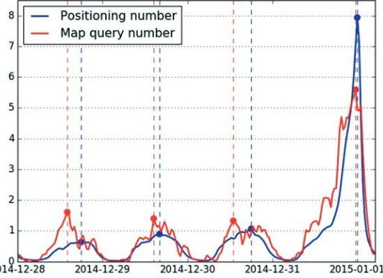
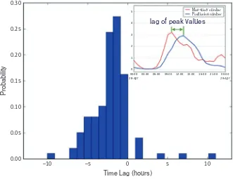
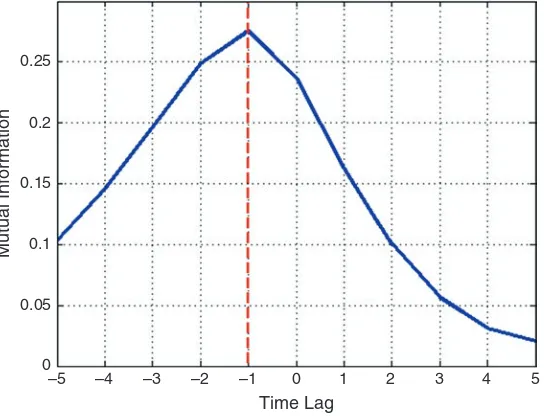
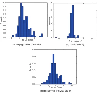
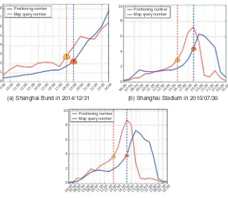
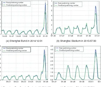
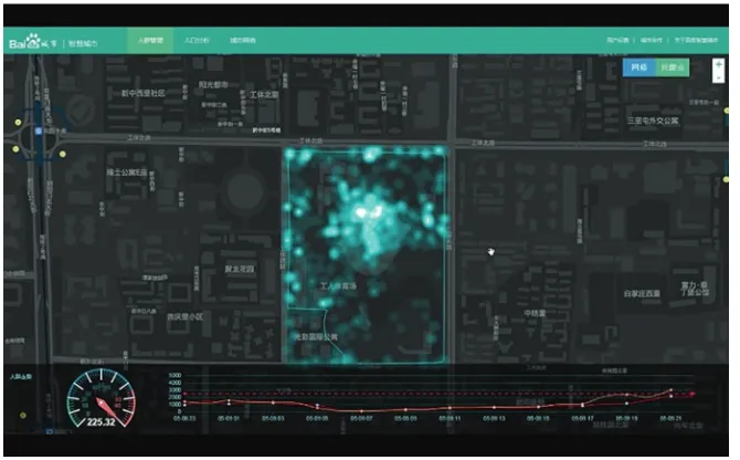
In this part, six chapters focus on application of SNS data for considering the possibilities of application on urban planning and management. Early Warning of Human Crowds Based on Query Data from Baidu Map: A Lesson from Shanghai Stampede by Wu, Pei, and Zhou in Chap. 2 takes a recent impressive stampede tragedy in Shanghai in 2014 as case study, where 36 people died and 49 were injured in celebration of the New Year’s Eve. Due to the innately stochastic and complicated individual movement, it is not easy to predict collective gatherings, which can potentially lead to crowd events. In this chapter, with applying the social big data generated on Baidu map, Wu et al. propose a novel approach to early warning such potential crowd disasters. Based on careful analysis and deep investigation on the Baidu map data, it is able to invoke warnings for potential crowd events about 13 h in advance. A sophisticated machine learning model with heterogeneous data (such as query data and positioning data) is proposed to quantitatively measure the risk of the potential crowd disasters.
“Research on Spatial Distribution Characteristics of Residents’ Emotions Based on Sina Weibo Big Data: A Case Study of Nanjing” in Chap. 3 is contributed by Zhen, Tang, and Chen. The city of Nanjing has been taken as case study in this study; Sina Weibo big data has been used to extract real-time emotions and space of residents, along with geo-location-based corresponding information. This study aims to analyze the spatial distribution characteristics of residents’ emotions in the overall Nanjing and in different places by using ArcGIS software with the grid sta-tistics and analysis method, which is a bid to provide the evidence for the optimiza-tion of urban space development. Urban planning should follow the idea of being people-oriented. With the fast development of cities, more attention needs to be focused on the perception and experiences towards space by residents.
These facts grounded for a general picture for the study on polycentric urban regions over the whole national territory.
In Chap. 5, “Assessment of Regional Economic Integration Based on Relational Data: The Case of the Yangtze River Delta,” Li, Miao, and Zhang suggested the regional economic integration index for measuring the degree of regional economic integration of the main cities. In the regional economic integration process, it is the relation between cities instead of the hierarchy system that forms the regional urban system. Based on the database of the Baidu Search Index, the information-based network is analyzed to characterize the flow of information. Based on the railway database, the transportation-based network is analyzed to characterize the flow of mobility. Based on the database of company registration information from China, the State Administration for Industry and Commerce, the firm-based network is analyzed to characterize the flow of capital and cargo in Shanghai Chang Sanjiao regional area. These three city networks are then compared and combined using multivariate analysis and interlocking network approaches.
In Chap. 6, “The Recognition of CAZ in Shanghai Based on Evaluated POI,” Liu and Liu argue that the upgrade of urban core from CBD to Central Activities Zone (CAZ) becomes a trend of many cities in China. This chapter proposes a relatively clear definition of CAZ through a comparison with CBD and then presents a method to identify the potential CAZ based on evaluated DAZHONGDIANPING dataset. Taking Shanghai as an example, a data process is proposed to calibrate the degree of functional mixture on aspects of retail, catering, office, leisure, culture, and rec-reation. Through the compilation of rasterized maps, the top 14 most dynamic places in downtown Shanghai are investigated, and three scenarios have been defined for the discussion of CAZ boundary.
“The Fear of Ebola: A Tale of Two Cities in China,” Chap. 7, is contributed by Ye, Li, Yang, Lee, and Wu. Emerging social issues have often led to rumor breeding and propagation in social media in China. In this chapter, we use the diffusion of Ebola rumors in social media networks as a case study. The topic of rumors is iden-tified based on Latent Dirichlet allocation method, and the diffusion process is explored using the space-time methods. By comparing Ebola rumors in the two cities, the chapter explores the relationship between the spread of rumors, user fac-tors, and contents. Public health-related rumors will harm social stability, and such noise detrimentally affects the quality of disease outbreak detection and prediction based on social media.
It is exciting for planners to study urban structure from a view of spatiotemporal analysis using individual mobility data that it is never possible by conventional sur-vey database. We can accurately investigate social big data information regarding where, when, and who are using SNS. However, it is impossible to identify personal information of SNS users individually because social big data are protected per-sonal information. LBS information of SNS is impossible to collect from all resi-dents because the number of SNS users is limited, and what we can investigate is spatiotemporal analysis of individual user or patterns of mass behaviors.
1.3 Part 3: POI for Exploring Urban Space Recognition
Collaborative mapping is the aggregation of web maps and user-generated content, from a group of individuals or entities. Points of interest (POIs) are recognized as one kind of big data based on collaborative mapping, which is not the sensor data from IoT. Because of data shortage problem in China, planners are using POI data to analyze current situation in planning process. There are also commercial POI collections that are sold on a subscription basis and usually are protected by its copyright. However, there are also many websites from which royalty-free POI col-lections can be obtained, e.g., SPOI (Smart Points of Interest).
POI is a kind of point data that stands for building points and is inputted by users of collaborative mapping. POI data obtained from OpenStreetMap with building usage is a popular trend among planners. POI data reflects the places where map-ping users are interested in. However, the POI does not cover all building data. A collaborative mapping platform is available for users to input their interested points. In addition, private companies for POI collections are active in inputting those points in their system. Even though POI is a kind of data that people are interested in, POI is recognized as substitutable data for database of urban land use in China. The benefit that planners can get from using POI is not only easy access to the POI data from the Internet but also time and money saving for planners to do field survey and use POI as some kind of complementarity to national survey database.
Chen, Xu, Wang, Du, and Li are working on identifying locations of retailing market, which is commercial function in urban area in Chap. 9, “Geographic Big Data’s Applications in Retailing Business Market.” Location has been considered as a determinant factor of success in retailing stores. However, their traditional meth-ods are highly likely to be too expensive and difficult to expand to the whole city or nation. In order to select the best site for each store, this chapter explores methods that based on POI data and other social media data for classifying the location to generating hierarchical trading areas. Results indicate that more than 70% of stores can be explained by business district classifications suggested in this work. Moreover, results indicate that POI aggregations can match the locations of two retail stores from 83% to 90%, respectively. Besides, the relationship of distance between POIs and stores can contribute to explaining the location of retail stores.
In Chap. 10, “Redefinition the Social Space Based on Social Atlas Analysis: A Case Study of Dongguan, China,” is contributed by Liu and Su. Social area analysis is a conventional approach to study social division and social structure, which is generally incapable to discover the diversity of social space. Liu and Su used the data of the Sixth Population Census and POI data to explore sociospatial features of a Chinese city. Based on demographic properties, social facilities, and organiza-tions, 11 types of social areas and 3 kinds of social spaces are identified. Particularly, rural community, rural-migrant-worker community, and urban community are dem-onstrated in Dongguan. The chapter declares that the method of social atlas relieves the limitations of social area analysis, which help to understand a very complex and diverse social space and reconstruct the research framework adapting to certain social situations in China.
Li, Wang, Li, Dang, and Song have explored four functions, namely, political center, cultural center, international communication center, and innovative center of science and technology, and the development of scientific and technological innova-tion in Beijing in Chap. 11, “The Spatial and Temporal Evoluinnova-tion of Innovative Function of Science and Technology of Beijing Based on the Analysis of Enterprise Data.” This chapter further focuses on analysis of Beijing’s high-tech industry and its spatial evolution based on POI enterprises data in order to conclude how the government policies influence the spatial evolution. Results show that spatial distri-bution of high-tech industries in Beijing spreads from city center to the periphery gradually under the guidance of government policies, in which it demonstrates that top-down policies are playing the key role in the innovation-driven stage.
1.4 Part 4: Mobile Device Data for Integrating Land Use
and Transportation Planning
Cell phone and car navigation system with GPS service are widely used in China where users carry all these devices. Besides personal desktop computer users, SNS app installed in smartphones is also carried by users. In this part, SNS is not included because social big data, such as messages and photos inputted by SNS users, has been discussed in Part I. Position signal or station information, as well as, time information recorded in mobile devices with GPS or smart cards for public trans-portation, which are generated by mobile devices or card reader devices automati-cally, are used for planning support in this part.
Position and time information are useful for spatiotemporal analysis. Hence, many planners in China are engaging to use the data for analyzing urban structure to intergrade land use and transportation planning, even though urban structure is also possible to be analyzed by conventional database of land use survey. Mobile device data is useful to understand urban structure based on human mobility at an individual level. The track and time of human mobility can be used to understand spatiotemporal characteristics of urban structure, which are not possible to be iden-tified by conventional database.
Lin, Ma, Chu, and Gao in Chap. 12, “Spatial Development Analysis of the Southern Area of Beijing Based on Multisource Data,” have explored GPS data of taxi, smart card data, and other types of data. There is an Action Plan of Promoting the Development of Southern Area of Beijing implemented by the Beijing govern-ment since 2009. For understanding how this action plan influences the southern area of Beijing, this chapter provides multidimensional analysis on existing prob-lems of the southern area of Beijing using multisource, such as taxi GPS data, tran-sit smart card data, second-hand property pricing data, and demographic data.