Land Use after the Tsunami
Supporting Education, Research and Development
in the Aceh Region
Syiah Kuala University, Banda Aceh, Indonesia
November 4-6, 2008
Proceedings
Managing Board
Dr. T. Fadrial Karmil
Syiah Kuala University, Banda Aceh, Indonesia
Dr. Arifudin Bidin
Tadulako University, Palu, Indonesia
Prof. Walter Wenzel
University of Natural Resources and Applied Life Science, Vienna, Austria
A PREDICTION STUDY OF WAVE PROPAGATION BEFORE AND AFTER
TSUNAMI IN ULEE LHEUE COASTAL WATERS, ACEH, INDONESIA Setiawan,
I., Y. Ilhamsyah, E. Miswar and A. Haddrevi
Ichsan Setiawan1, Yopi Ilhamsyah1, Edy Miswar1 and Aykal Haddrevi1
Marine Sciences Department, Faculty of Mathematics and Natural Sciences, Syiah Kuala Universit, Banda Aceh, Indonesia; [email protected]
Abstract
The prediction of wave propagation was done using wave numerical model for Ulee Lheue coastal waters, Banda Aceh. The purpose of the present research is to predict the wave propagation in Ulee Lheue coastal waters. The wind velocity and direction data for 2001 to 2006 were used to predict wave propagation before and after Tsunami. It is showed the maximum height of wave is 0.33 m during wet season and 0.25 m in dry season. Meanwhile, the maximum height after Tsunami is 1.50 m and 0.66 m during wet and dry season.
Key words: Wave refraction, maximum height of wave before and after tsunami in Ulee Lheue coastal waters
Introduction
Ulee Lheue coastal waters is situated in the northwest of Banda Aceh. It is a main sea trade route from Ulee Lheue port to Balohan Sabang port. Erosion and Sedimentation are major recent problems in this region, mostly caused by the wave striking upon the coast. Thereby, a forecast research of wave propagation which in advance results in wave height distribution is essential to carry out.
Material and Methods
The simulation of wave propagation was done by means of wave numerical model (Figure 1). Such incident wave data as height, angle and period were predicted using formulas taken from US Army Corps of Engineers, 2006. In addition, such initial data of wind as velocity and direction are taken from Agency of Meteorology and Geophysics (BMG) for 2001 - November 2004 and 2005-2006 for both pre-Tsunami and post-Tsunami data, respectively. In the meantime, the equation taken from US Army Corps of Engineers, 1984 was used to calculate wind Fetch. Pre-Tsunami bathymetry data are acquired from Agency of Hydro-Oceanography (Dishidros), 2001 (Figure 2). Meanwhile, Post-Tsunami bathymetry data are acquired from Departemen Pekerjaan Umum Dinas Sumber Daya Perairan Provinsi NAD for 2005 (Figure 3). Both data were used as the initial input in the model. The numerical solutions are derived from wave equation taken from van Rijn, 1990 and Koutitas, 1984. On the other hand, equation H =H0KsKr was then used to calculate
Model is run based on the following flowchart shown below:
The calculation of x-y orthogonal wave The equation used are as follows:
The calculation of refraction coefficient The equation used are as follows:
2
Wave height calculation H The equation used are as follows:
R SK
K H
H = 0
The calculation of shoaling coefficient The equation used are as follows:
( ) [ ]
(x,y) reference of orthogonal wave Wave height distribution
END
1
START
Bathimetry input (depth)
Wind input
Calculation of Fetch,
∑
The determination of orthogonal wave direction with wave refraction equation
The equation used are as follows:
Calculation of speed of wave propagation
The equation used are as follows:
Fig. 2: The digitized pre-Tsunami Bathymetri data (m) according to Agency of Hydro-Oceanography (Dishidros), 2001. 1). Ulee Lheue port 2). Main road to Banda Aceh. 3). Main road to Lho’nga.
N
12
3
Fig. 3: The digitized pre-Tsunami Bathymetri data (m) according to Departemen Pekerjaan Umum Dinas Sumber Daya Perairan Provinsi NAD. 1). Ulee Lheue port 2). Main road to Banda Aceh. 3). Main road to Lho’nga.
Results and Discussion
The simulation of wave propagation
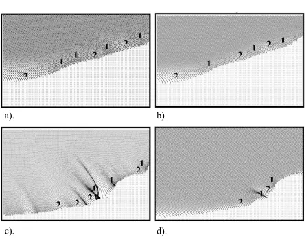
Figure 4 showed the propagation of wave for wet and dry season before and after Tsunami. The propagation eventually brings about the divergence and convergence zone. The latter occurred in cape where energy is greater than in bay (divergence zone). Erosion-Sedimentation are depicted by wave energy representing the formation of sedimentation in divergence zone where orthogonal wave spread in this area whereas erosion occurred in the convergence zone on the contrary.
1
3
2
a).
b).
c).
d).
Fig. 4: Wave propagation in Ulee Lheue waters for a). wet season before Tsunami, b). dry season before Tsunami, c). wet season after Tsunami, and d). dry season after Tsunami. 1). Convergence zone 2). Divergence zone.
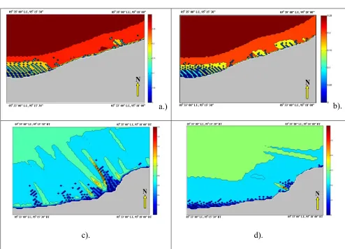
Wave Height Distribution
N
050 35’ 00” LU, 950 15’ 30” 050 35’ 00” LU, 95018’ 00”
050 33’ 00” LU, 950 15’ 30” 050 33’ 00” LU, 95018’ 00”
a.)
N
05035’ 00” LU, 95015’ 30”
050
35’ 00” LU, 950
18’ 00”
05033’ 00” LU, 95015’ 30” 050 33’ 00” LU, 95018’ 00”
b).
N
050 35’ 00” LU, 950 15’ 30” BT
050 35’ 00” LU, 950 18’ 00” BT
050 33’ 00” LU, 950 15’ 30” BT 050 33’ 00” LU, 950 18’ 00” BT
c).
N
050 35’ 00” LU, 950 15’ 30” BT 050 35’ 00” LU, 950 18’ 00” BT
050 33’ 00” LU, 950 15’ 30” BT 050 33’ 00” LU, 950 18’ 00” BT
d).
Fig. 5: The wave height distributions for a). scenario for wet season before Tsunami (m) b). scenario for dry season before Tsunami (m), c). scenario for wet season after Tsunami (m) and d). scenario for dry season after Tsunami (m).
Conclusions
From the results above, it can be concluded that:
1. The maximum height of wave propagation before Tsunami for wet and dry season are 0.33 and 0.25 m.
2. The maximum height of wave propagation after Tsunami for wet and dry season are 1.5 and 0.66 m.
3. The simulation of wave propagation is helpful in locating sedimentation and erosion zone.
Acknowledgments
The author wished to express the gratitude to Prof. Dr. Syamsul Rizal for kindly supervise and assist during the research, and at last but least to all my colleagues for kindly critical, suggestion and support during the research.
References
1. Dean, R. and Dalrymple, R., (1984), “Water Wave Mechanics for Engineers and
Scientist”, Prentice Hall Press.
3. U.S Army Coastal Engineering Research Center, (1984), “Shore Protection Manual
Volume I”, Department Of The Army Corps Of Engineering, Washington D.C, USA
4. U.S Army Coastal Engineering Research Center, (2006), “Coastal
EngineeringManual”, Department Of The Army Corps Of Engineering, Washington
D.C, USA
5. van Rijn,L.C., (1990), “Principles of Fluid Flow and Surface Waves in Rivers,
Estuaries, Seas, and Oceans”, University of Utrecht, Department of Physical