JEDDAH HISTORICAL BUILDING INFORMATION MODELING "JHBIM"
-OBJECT LIBRARY
A.Baik a, , A. Alitany b, J. Boehm c , S. Robson d
a Dept. of Geomatic Engineering, University College London, Gower Street, London, WC1E 6BT UK – [email protected]
bDept. EGAI , Expresió Gráfica Arquitectónica I ETS Arquitectura Barcelona-UPC, Barcelona, Spain [email protected]
c
Dept. of Geomatic Engineering, University College London, Gower Street, London, WC1E 6BT UK – [email protected]
d Dept. of Geomatic Engineering, University College London, Gower Street, London, WC1E 6BT UK – [email protected]
KEY WORDS:HERITAGE DOCUMANTION, JHBIM, TLS, OLD JEDDAH, AL-BALAD.
ABSTRACT:
The theory of using Building Information Modelling “BIM” has been used in several Heritage places in the worldwide, in the case of conserving, documenting, managing, and creating full engineering drawings and information. However, one of the most serious issues that facing many experts in order to use the Historical Building Information Modelling “HBIM”, is creating the complicated architectural elements of these Historical buildings. In fact, many of these outstanding architectural elements have been designed and created in the site to fit the exact location. Similarly, this issue has been faced the experts in Old Jeddah in order to use the BIM method for Old Jeddah historical Building. Moreover, The Saudi Arabian City has a long history as it contains large number of historic houses and buildings that were built since the 16th century. Furthermore, the BIM model of the historical building in Old Jeddah always take a lot of time, due to the unique of Hijazi architectural elements and no such elements library, which have been took a lot of time to be modelled. This paper will focus on building the Hijazi architectural elements library based on laser scanner and image survey data. This solution will reduce the time to complete the HBIM model and offering in depth and rich digital architectural elements library to be used in any heritage projects in Al-Balad district, Jeddah City.
1. INTRODUCTION
1.1 Old Jeddah Background
Jeddah City has a very long history dates back to more than 3000 years ago and the Old City contains a lot of historic buildings “around 350”, which have been built for more than 350 years ago with special characters that exhibit the very culture of the nation. The City is placed in the west side of Hijaz region, through a coastline on the Red Sea. The City is valuable that because it is the welcoming port to the two holy cities “Madinah and Makkah” of Islam.
Moreover, Jeddah is considered as the tourism and economic capital of the Kingdom of Saudi Arabia(Telmesani et al., 2009). Furthermore, according to (Al-Fakahani, 2005) “Muslim and Arab writers noted that the name Jeddah is taken from the Arabic word for grandmother, while “Jed” means grandfather in Arabic”. This links to traditions in the region to the north east of Jeddah where Eve was buried by her descendants in an area known as the cemetery of Mother Eve.
1.2 JHBIM issues
The main issue with the HBIM for Old Jeddah building is no such digital architectural elements library to build the HBIM model. On the other hand, creating the architectural elements of these buildings took a lot of time to be modelled. This issue has been effected the schedule of building the JHBIM model (Baik et al., 2013).
1.3 Aims
We aim at building a historical Hijazi architectural elements library based on laser scanner and image survey data with offering Hijazi elements in depth and without losing large amount of these architectural objects.
This solution will reduce the time to complete the JHBIM model and offering rich digital architectural elements library to be used in any heritage projects in Old Jeddah.
2. PREVIOUS WORKS
The previous works were focused on two methods to deal with Old Jeddah historical buildings and the Hijazi elements toward the Jeddah Historical Building Information “JHBIM” (Baik et al., 2013).
The main problems that face Old Jeddah City recently are how can the municipality of Old Jeddah City save and preserve them from the possibility of erosion and collapse by human and natural reasons, and disasters such as fires.
Moreover, over the last thirty years large numbers of the Historical buildings in Old Jeddah have been damaged and destroyed, which erasing thousands years of culture and history. Al-Balad district in Jeddahhas the possibility to become one of the important World Heritage Sites with just more attention and preserving for these unique coral buildings.
2.1 Jeddah Historical Building Information “JHBIM”
The Aim of using JHBIM was to provide an interactive solution to move from the zero level of BIM “CAD and 2D drawings” to more advance levels of BIM “level 2 and level 3”, in case of supporting the protective preservation, sharing of the information of such historical buildings, together for expert users, societies and experts involved in decision making process (Eastman et al., 2011; Fussel et al., 2009).
Additionally, According to (Saygi et al., 2013) “BIM will provide the possibility to represent all views (3D model, plans, sections, elevations, and details) automatically", according to this, JHBIM will be improved the coordination and visualization between the drawings.
Furthermore, according to (Murphy et al., 2009) the purpose of using Historic Building Information Modeling “HBIM” is to “outline in detail the procedure of remote data capture using laser scanning and the subsequent processing required in order to identify a new methodology for creating full engineering drawings (orthographic and 3D models) from laser scan and image survey data for historic structures”.
According to (Baik et al., 2013) “The Heritage Preservation field can offer several things to the JHBIM such as the understanding of heritage buildings in Old Jeddah and the context, knowledge of materials, construction techniques and the building pathologies, understanding of heritage buildings in Old Jeddah with a wide range of materials and assemblies that are not documented and are not available from stock libraries of 3D model parts”.
Furthermore, JHBIM can offer number of advantages to The Heritage preservation arena such as “offering full study of proposed renovations and changes before final decisions are made, assisting in maintenance efforts, damage detection on building’s surfaces, planning for maintenance and repairs, and allowing wider public building experience as models can be viewed with free viewer software from remote locations” (Baik et al., 2013).
Moreover, the remote reviewing for exterior and interior of the historical building with improving the management performance and better understanding to decision-making procedure of the preservation and the conservation, which will be offered by using JHBIM.
According to (Baik et al., 2013) “As such, decision makers in Old Jeddah municipality can be more efficient and effective”. Some of the benefits of using JHBIM can be as reducing the time to deliver the project "4 D", reducing the cost "5 D", "6 D" lifecycle, and representing the information of the building in Moreover, the limited time and the difficulty to move the laser scanning “Leica Scan Station C10” in some dangerous areas were the main reasons of using both of these two approaches. Moreover, the laser scanning cannot capture some details such as the top of the Roshan.
2.1.1 Laser scanning approach
The first step forwards the JHBIM model begun with the laser scanning survey to one of the historical building in Old Jeddah as case study. In the project we used Leica Scan Station C10. The laser survey took a week.
The most suitable locations were used for the scanning station and scan targets “black/white”, in case of covering the part that will be scanned therefore perfect visibility can be made.
Furthermore, to perform better accuracy and to merge the scan stations, three “black/white” marks at minimum need to be used in common over these real ward stations.
In overall, 8 individual scans were carried out, with over six million data points combined together.
The laser scanning distance was about 10 to 20 m for the exterior and 7 cm was the scanning resolution. About 30 minutes for each scan settings and targets registering have been taken; these rely on the target quantity. Moreover, the laser scanning survey spent less than 15 minutes for each scans; on the other hand, more than 15 minutes took for the images scanning. Second steps, cloud points data cleaning “Noise” and the registration of the point clouds. About four days have been took to finish this step took.
Afterward, numbers of scans coinciding points in interfering parts were used to register the real words scans. The Leica Cyclone program was used to clean up the unimportant point clouds data. Third steps, we inputted the Point Clouds data to the Autodesk Revit for the “Modelling” purpose. Once receiving the prepared point clouds data, we used Autodesk Revit to build the JHBIM model.
According to (Baik et al., 2013) the reasons to use Autodesk Revit are “fast built and modify to the 3D model, high quality construction documents and advance level of flexibility”. The first trial was processing of the incredible amount for the captured information, which was calmed over Images survey, on-site inspections and, the “TLS” Terrestrial laser scanning beside to the high level of the details of the Mashrabiyah and Roshan. Consequently, the 3D modelling of “house was started with the Roshan and Mashrabiyah modelling. Moreover, the East elevation’s Roshans were modelled, started from the ground floor up to the roof.
After, modelled the East and the south Elevations Roshans, the Laser scanning’s cloud points bounders were used as guide lines to draw the floors plans for the house. Furthermore, one of the main issues in using JHBIM for the historical buildings in Old Jeddah was how to merge between the families based (component-based) approach of JHBIM and traditional methods of construction.
In the case of House project, many elements had been faced which could not just be repeated as family based; such as the Roshan elements; since most of these Rawshans had been designed and made on-site in turn to be fitted in the exact location. As a result, Roshans and Mashrabiyah had been given more attention especially the visual fidelity of the JHBIM model by creating Roshan drawings and rendering during the method(Baik et al., 2013).
2.1.2 Image-based approach
Recently, photogrammetry and 3D modelling approaches have been rapidly advancing with part of the focus on developing new technologies for applications on architectural heritage documentation. Recent advances have allowed semi-automated and automated solutions based on Dense Stereo Matching (DSM) (Furukawa and Ponce, 2010; Hirschmuller, 2008) and Structure from Motion (SFM) (Agarwal et al., 2011, p. 20; Pollefeys et al., 2008; Vergauwen and Van Gool, 2006) offered commercially availability and web-based software provided accurate results to obtain 3D point clouds and textured mesh surfaces. The full automation of the process of image orientation and matching was presented to facilitate and speed up the data processing task that, in some cases, could be a never-ending process if performed manually.
The dense cloud of 3D points as a result by itself is typically not very useful. In this regard, a number of post-processing steps are usually carried out. This post processing often involves filling holes, filtering; smoothing, meshing/triangulation and sometimes NURBS patch conversion. A separate 3D software program usually carries out these functions.
In the first stage of surveying part, three aspects were considered: first, the selection of a suitable method that best fits according to current state of art of image-based approaches and 3D modelling techniques in the existing architectural heritage documentation; second, appreciating the variety and complexity of the Roshan element. Thus we divided the surveying and modelling procedures into three stages: 1) structural parts: base, body and head that defined the entire element. On this stage we used the semi-automated digital close-range photogrammetry method using a calibrated camera; 2) ornamented and detailed sub-components, which are related to ornamented parts, using DSM and SFM approaches. In this part, the PhotoModeler Scanner© (PMS©) and Autodesk© RECAP™ 360 software has been tested on the Roshans, provided flexible and an accurate solution to get textured surfaces and 3D point clouds results in order to be used for visualisation and educational purposes ; finally we used Rhinoceros© 3D modelling software for interpretation and combining parts (Alitany et al., 2013). In the first stage, we started by detecting the main points that form the structured parts of the Roshans and defined the relevant profiles extracted in semi-automatic or manually method by using PhotoModeler Scanner© (PMS©), a digital photogrammetry application. We followed the 3x3 CIPA rules(Waldhäusl and Ogleby, 1994, p. 3); from 3-10 images we captured the Roshan total mass. The digital camera with focal lengths 18 and 35 mm were used and calibrated through reference to a calibration grid.
All detected control points on the Roshan had to appear in at least every three adjacent images taken. After that, the combination of this data allowed the definition of profiles from the generated baselines from edges and the surfaces while allowing classification of the relative importance of the parts in these wooden elements (Figure 2).
In the second stage, we used the DSM and SFM as a set of tools for extracting and manipulating a dense pattern of point clouds from images, which allows accurate mesh surfaces for ornamented and detailed parts. PMS© and Autodesk© RECAP™ 360 are capable of performing modelling and measuring tasks with the additional attribute to scan photo pairs to produce point clouds and mesh surfaces.
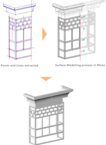
Figure 1 JHBIM model by Autodesk Revit.
Figure 2 Modelling processes of structural parts of the Roshan.
Our DSM experiment is presented by describing a complete process from acquisition images until the final result. First of all, before the capturing images, to obtain a high level of accuracy, the camera calibration process was required.
By photographing the calibration sheet, the camera defects can be managed and calculated through PMS©. During the stage of acquiring complex details, the size of the projection of the pixel on the object has to be adjusted by varying the distance to the object and/or focal length. The result was a noisy point cloud. It is important to pay special attention to the illumination aspect, since it can be a source of texture, in order to avoid sharp shadows and marked radiometric differences within a sequence depending on the form and the granularity.
However, the SFM approach includes fully automated camera calibration, offering more speed and flexibility when capturing details such as using mobile phone devices. It simply requires the user to supply a minimum of three images. Turning around the object and capturing a large number of images in sequence, in which the angle between one shot and the other is about 5-10 degrees, in order to recover the 3D geometry which would allow the recovery of the fine details of an object and would also avoid smoothing results.
This method needed some preliminary evaluations of the survey procedures, by ensuring a 75 % overlap of captured areas between images, in order to allow the manual stitching in case of inaccurate matching during the orientation process.
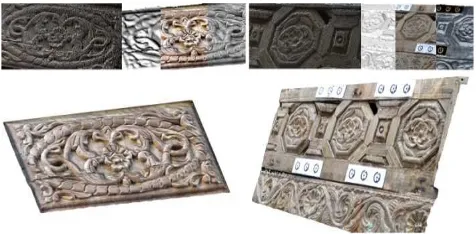
Figure 3 Examples of mesh surfaces results of ornamented parts triangulated from point clouds processed DSM approach. The SFM approach was used in cases where the DSM approach was hard to apply due to the location of the Roshan on higher levels of the building’s facade, where placing targets and applying manual measurements was either difficult or impossible. Furthermore, in some cases, the narrowness of the alleys at the site raised difficulties in both the acquisition stage, while planning and implementing the appropriate techniques for capturing the geometry, and the photogrammetric image registration phase.
However, the selection of the right images is required for orientation and getting an accurate result, in both the orientation and the image-modelling phase.
Thus, the main issue is to have more than five images for a captured detail with an optimal relative camera angle. Also, in other Roshan cases, the acquisition work was divided according to the Roshan’s main parts, which required more images, capturing more control points and orienting the images several times.
3. JHBIM ARCHITECTURAL LIBRARY
The Hijazi Architectural objects library “HAOL”, which will be depended on the image survey and point cloud data, will recreating some of the past, to conserve or to restore these unique parts of these Historical Building. Furthermore, these Hijazi Object such as Roshan and Mashrabiyah, become as vocabulary of the Old Jeddah building. These Architectural vocabularies are the main cause of the beauty of these historical building. On the other hand, there is a huge gab in the Hijazi architectural library to provide these unique elements. Due to this issue we created our architectural library. Moreover, the objects library of JHBIM will be connected to the data collected in a database, where each single modifies of a parameter bases a change in the shape of the object. As a result, considering the detail’s level is very important and how can we simplify these object models to be fit for preservation plan, linked to the real opportunity to modify the parameters of the shape of the architectonic elements, in particular, of Old Jeddah historical building object that are always unrivalled and irregular. According to (Dore and Murphyb, n.d.) “Due to the individuation of the form, grammar and stylistic rules can be used to create a library of historical elements” of Old Jeddah historical buildings. Moreover, regarding to the levels of detail, we will use the (LOD) Level of Development from (AIA) American Institute of Architects document E202. The levels will be display in Revit, in three levels which are “Course, Medium, and Fine” (Paul, 2013) . Each of these levels will be suitable for the purpose of using them. Furthermore, we will use different numbers of architectonic guides to get proportions, quantities, measurements, and geometrical structure information.
The result will let both to build an abacus of local constructive object and to match the objects’ real dimensions with the information derived from any previous architectural drawings. This will make the models detailed according to the real conditions. The concept of this library is to use as plug-in for existing BIM software platforms such as Autodesk Revit. Moreover, The Hijazi Architectural objects library “HAOL”, will be introduced, documented, and will support any future projects in Old Jeddah.
Figure 4 The results of the SFM approach applications in detailed ornamented parts by Autodesk© RECAP™ 360. ISPRS Annals of the Photogrammetry, Remote Sensing and Spatial Information Sciences, Volume II-5, 2014
3.1 The Method of Creating JHBIM Object Library
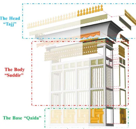
The theory toward the Hijazi Architectural objects library started after modelling these elements in 3D modelling software such as Autodesk Revit and Rhinoceros. The framework of creating the Hijazi Architectural objects library will be started with analysing and understanding the architectural rules of these elements. Secondly, understanding the purposes and the level of details are very important to get the suitable quality for the model that we need. Thirdly, we classified the Hijazi Architectural objects related to numbers of criteria such as the shape, the amount of details and the style of these details. In the beginning we divided the library to three main types “i.e. Roshan, Doors and Windows” (Figure 6).
Next, we picked one of the important types of Hijazi object which is The Roshan, this object divided in the library into three parts. Each of these parts divided into three subtypes. By divided the elements to subtypes such as what we did in the Rowshan case, we will reduce the complexity and simple to be understood. Fourthly, we created the Roshan structures farm and after that we modelled each single part nearly as the real condition. Finally, after the 3D modelling stage of the main structural and ornamented and complex detailed parts, these multiple data must be integrated in order to complete the final 3D model of the Roshan element, which will be appropriate for exportation to JHBIM system.
Moreover, there are numbers of programs that can be used to build the models of the object library. In this stage we used two programs which were Autodesk Revit and Rhinoceros©. Both
programs have many positives and negatives, however, both can complete each other. Furthermore, using Rhino software allowed work with different 3D model formats, which was useful for subsequent model integration, where the extracted 3D data of the main parts were exported as .3dm (Rhino format); the complex components were exported in “.obj” format. This method is relatively easy to use and works with many formats, which is useful for the merging and integration of the different parts of the model. Accurate positions of the Roshans’ corners points and their major structural elements were defined based on the generated 3D data of the control points and targets in PMS© with reference points support and measured dimensions. In this way different surfaces were generated. Merging partial components was also performed in Rhinoceros© due to the various advantages outlined above and based on the criteria and standard Roshan composition. This process is not easy because we had to combine different types of 3D models and images with different resolutions. This requires removing the redundant parts of various objects and merging models based on initial reference points, which then export the results to a visual simulation application that allows the appearance of the Roshan model to be shown. The exportation process of produced parts of the Roshan relies only on geometric information. These 3D data were employed to be a parametric component in building information modelling (BIM) systems.
The second program we were used was Autodesk® Revit®. The Revit® software has a lot of advantages such as quick built and changes to the 3D model, high quality construction documents and high level of flexibility(Baik et al., 2013). In fact, to deal with such Hijazi object Autodesk® Revit® is using two methods “Revit Families”. These Revit Families are built in an environment called “Family Editor”, which will allow us to work directly inside of the family file. All these families are saved as “.RFA” extension.
The first method is by using the “Traditional Family Editor”. In this method, the object must be sketched on 2D work plan. The second method is by using the “Massing Family. The common thing between the two methods is saving the file in “.RFA” extension, however, the mine different is that the Massing environment is a 3D work environment which will allow us to work directly in 3d view. However, According to Paul Aubin “the mass category is only useful as a “clay model” or “study model” in the project”(Paul, 2013). Moreover, as Cooperation between Autodesk® Revit® and Rhinoceros©, some of the Roshans’ parts or modules were imported into DWG or IFC file format. These vector lines were defined as parametric values. By using these values, we can create an endless number of designs. Thus, these parametric components can be used in the design, construction and post-construction process and for management information purposes.
JHBIM
Objects Library
Windows Doors Roshan
Figure 7 Roshan main parts
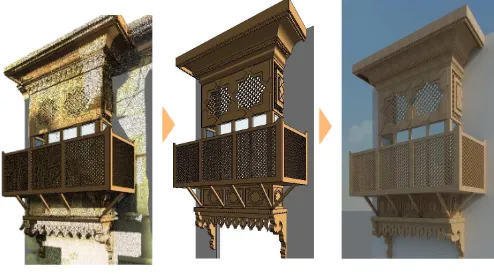
Figure 8 In JHBIM, the 3D models are transformed into parametric models to be used in projects and to generate new designs.
Figure 6 JHBIM objects library layout.
4. CONCLUSION
An approach of JHBIM for Building Hijazi architectural elements library is proposed. The process is divided on three stages, first capturing data using of range/image-based approaches; second, data processing; finally, defining and modelling the historic objects as parametric components using BIM system.
In conclusion, the approach is evaluated; indicate the potential of BIM system to use in the documentation of Hijazi historical elements. This study aimed to the building of the architectural elements libraries beginning from their survey. The obtained results of 3D architectural data have surveyed and produced based on laser scanner and image survey technologies. Furthermore, to build the JHBIM model we spend more than five weeks; however, by using the Hijazi architectural elements library we expect to reduce the time to around week or two. The use of these technologies has facilitated and speeds up the process of creation architectural drawing of wooden elements and ornamented details of the historical facades.
The remarkable improvements are related to the amount of details and accuracy of parametric objects. In BIM automatically produces all architectural drawing, 3D models, 2D orthographic plans and sections, schedules/quantities and sheets. All outcome data can be used for a number of applications over time, GIS, reconstruction, design , documentation, education and finally sharing of information and knowledge dissemination of architectural heritage for professional users, societies and experts involved in decision making process.
4.1 Acknowledgement
I would like to thank Eng. Sami Nawar The director of Jeddah Historic Preservation Department, Jeddah Municipality for his corporation and the useful information about Old Jeddah in different areas. Also, I would thank Prof. Abdalmageed Daghistani and the teaching staff of Geomatics dep. at King Abdul-Aziz University in Jeddah for the corporation.
5. REFERENCES
References from Journals:
Agarwal, S., Furukawa, Y., Snavely, N., Simon, I., Curless, B., Seitz, S.M., Szeliski, R., 2011. Building rome in a day. Commun. ACM 54, 105–112.
Al-Fakahani, H., 2005. Jeddah: The bridge of the red sea: Progress and development, The Arab Publishing House for Encyclopedias. Jeddah, KSA.
Alitany, A., REDONDO, E., Adas, A., 2013. The 3D Documentation of Projected Wooden Windows (The Roshans) in the Old City of Jeddah (Saudi Arabia) Using Image-based Techniques.
Baik, A., Boehm, J., Robson, S., 2013. Jeddah Historical Building Information Modelling “JHBIM” Old Jeddah –Saudi Arabia.
Dore, C., Murphyb, M., n.d. Semi-Automatic Modelling Of Building Facades With Shape Grammars Using Historic Building Information Modelling.
Eastman, C., Teicholz, P., Sacks, R., Liston, K., 2011. BIM handbook: A guide to building information modeling for owners, managers, designers, engineers and contractors. Wiley. com.
Fussel, T., Beazley, S., Aranda-Mena, G., Chevez, A., Crawford, J., Succar, B., Drogemuller, R., Gard, S., Nielsen, D., 2009. National guidelines for digital modelling.
Murphy, M., McGovern, E., Pavia, S., 2009. Historic building information modelling (HBIM). Struct. Surv. 27, 311–327. doi:10.1108/02630800910985108
Paul, A., 2013. Renaissance Revit: Creating Classical Architecture with Modern Software, 1B edition. ed. CreateSpace Independent Publishing Platform, USA.
Pollefeys, M., Nistér, D., Frahm, J.-M., Akbarzadeh, A., Mordohai, P., Clipp, B., Engels, C., Gallup, D., Kim, S.-J., Merrell, P., Salmi, C., Sinha, S., Talton, B., Wang, L., Yang, Q., Stewénius, H., Yang, R., Welch, G., Towles, H., 2008. Detailed Real-Time Urban 3D Reconstruction from Video. Int. J. Comput. Vis.
Saygi, gamze, Agugiaro, G., Hamamcıoğ lu - Turan, M., Remondino, F., 2013. Evaluation Of GIS and BIM Roles for the Information Management of Historical Buildings. ISPRS Ann. Photogramm. Remote Sens. Spat. Inf. Sci. Vol. II-5W1 2013 XXIV Int. CIPA Symp. 2 – 6 Sept. 2013 Strasbg. Fr. 283 – 288. Telmesani, A., Sarouji, F., Adas, A., 2009. Old Jeddah A Traditional Arab Muslim City In Saudi Arabia, 1st ed. ed. King Fahad national library, Jeddah.
Vergauwen, M., Van Gool, L., 2006. Web-based 3d reconstruction service. Mach. Vis. Appl. 17, 411–426.
Waldhäusl, P., Ogleby, C.L., 1994. 3 x 3 rules for simple photogrammetric documentation of architecture. Int. Arch. Photogramm. Remote Sens. 30, 426–429.
Figure 9 Steps of the Roshan modelling
References from Books:
Telmesani, A., Sarouji, F., Adas, A., 2009. Old Jeddah A Traditional Arab Muslim City In Saudi Arabia, 1st ed. ed. King Fahad national library, Jeddah.
Paul, A., 2013. Renaissance Revit: Creating Classical Architecture with Modern Software, 1B edition. ed. CreateSpace Independent Publishing Platform, USA.
References from interview:
SAMI, N., 2013. Jeddah Historic Preservation Department, Jeddah Municipality.