Open Geospatial Consortium
Date:2010-12-13 Reference number of this document: OGC 10-184
Category: (Public) Engineering Report
Editor:George Percivall
OGC
®Fusion Standards Study, Phase 2 Engineering
Report
Copyright © 2010 Open Geospatial Consortium
To obtain additional rights of use, visit http://www.opengeospatial.org/legal/.
Warning
This document is not an OGC Standard. This document is an OGC Public
Engineering Report created as a deliverable in an OGC Interoperability Initiative and is not an official position of the OGC membership. It is distributed for review and comment. It is subject to change without notice and may not be referred to as an OGC Standard. Further, any OGC Engineering Report should not be referenced as required or mandatory technology in procurements.
Document type: OGC® Engineering Report
Document subtype: NA
Document stage: Approved for public release
ii Copyright © 2012 Open Geospatial Consortium License Agreement
Permission is hereby granted by the Open Geospatial Consortium, ("Licensor"), free of charge and subject to the terms set forth below, to any person obtaining a copy of this Intellectual Property and any associated documentation, to deal in the Intellectual Property without restriction (except as set forth below), including without limitation the rights to implement, use, copy, modify, merge, publish, distribute, and/or sublicense copies of the Intellectual Property, and to permit persons to whom the Intellectual Property is furnished to do so, provided that all copyright notices on the intellectual property are retained intact and that each person to whom the Intellectual Property is furnished agrees to the terms of this Agreement.
If you modify the Intellectual Property, all copies of the modified Intellectual Property must include, in addition to the above copyright notice, a notice that the Intellectual Property includes modifications that have not been approved or adopted by LICENSOR.
THIS LICENSE IS A COPYRIGHT LICENSE ONLY, AND DOES NOT CONVEY ANY RIGHTS UNDER ANY PATENTS THAT MAY BE IN FORCE ANYWHERE IN THE WORLD.
THE INTELLECTUAL PROPERTY IS PROVIDED "AS IS", WITHOUT WARRANTY OF ANY KIND, EXPRESS OR IMPLIED, INCLUDING BUT NOT LIMITED TO THE WARRANTIES OF MERCHANTABILITY, FITNESS FOR A PARTICULAR PURPOSE, AND NONINFRINGEMENT OF THIRD PARTY RIGHTS. THE COPYRIGHT HOLDER OR HOLDERS INCLUDED IN THIS NOTICE DO NOT WARRANT THAT THE FUNCTIONS CONTAINED IN THE INTELLECTUAL PROPERTY WILL MEET YOUR REQUIREMENTS OR THAT THE OPERATION OF THE INTELLECTUAL PROPERTY WILL BE UNINTERRUPTED OR ERROR FREE. ANY USE OF THE INTELLECTUAL PROPERTY SHALL BE MADE ENTIRELY AT THE USER’S OWN RISK. IN NO EVENT SHALL THE COPYRIGHT HOLDER OR ANY CONTRIBUTOR OF INTELLECTUAL PROPERTY RIGHTS TO THE INTELLECTUAL PROPERTY BE LIABLE FOR ANY CLAIM, OR ANY DIRECT, SPECIAL, INDIRECT OR CONSEQUENTIAL DAMAGES, OR ANY DAMAGES WHATSOEVER RESULTING FROM ANY ALLEGED INFRINGEMENT OR ANY LOSS OF USE, DATA OR PROFITS, WHETHER IN AN ACTION OF CONTRACT, NEGLIGENCE OR UNDER ANY OTHER LEGAL THEORY, ARISING OUT OF OR IN CONNECTION WITH THE IMPLEMENTATION, USE, COMMERCIALIZATION OR PERFORMANCE OF THIS INTELLECTUAL PROPERTY.
This license is effective until terminated. You may terminate it at any time by destroying the Intellectual Property together with all copies in any form. The license will also terminate if you fail to comply with any term or condition of this Agreement. Except as provided in the following sentence, no such termination of this license shall require the termination of any third party end-user sublicense to the Intellectual Property which is in force as of the date of notice of such termination. In addition, should the Intellectual Property, or the operation of the Intellectual Property, infringe, or in LICENSOR’s sole opinion be likely to infringe, any patent, copyright, trademark or other right of a third party, you agree that LICENSOR, in its sole discretion, may terminate this license without any compensation or liability to you, your licensees or any other party. You agree upon termination of any kind to destroy or cause to be destroyed the Intellectual Property together with all copies in any form, whether held by you or by any third party.
Except as contained in this notice, the name of LICENSOR or of any other holder of a copyright in all or part of the Intellectual Property shall not be used in advertising or otherwise to promote the sale, use or other dealings in this Intellectual Property without prior written authorization of LICENSOR or such copyright holder. LICENSOR is and shall at all times be the sole entity that may authorize you or any third party to use certification marks, trademarks or other special designations to indicate compliance with any LICENSOR standards or specifications.
This Agreement is governed by the laws of the Commonwealth of Massachusetts. The application to this Agreement of the United Nations Convention on Contracts for the International Sale of Goods is hereby expressly excluded. In the event any provision of this Agreement shall be deemed unenforceable, void or invalid, such provision shall be modified so as to make it valid and enforceable, and as so modified the entire Agreement shall remain in full force and effect. No decision, action or inaction by LICENSOR shall be construed to be a waiver of any rights or remedies available to it.
ii Co
Preface
Making new connections in existing data is a powerful method to gain understanding of the world. Such fusion of data is not a new topic but new technology provides
opportunities to enhance this ubiquitous process. Data fusion in distributed information environments with interoperability based on open standards is radically changing the classical domains of data fusion while inventing entirely new ways to discern
relationships in data with little structure. Associations based on locations and times are of the most primary type.
This Engineering Report summarizes two phases of the Open Geospatial Consortium (OGC®) Fusion Standards study and of the fusion prototypes developed during the OWS-7 Testbed which occurred between the two study phases. Recommendations from the first phase of the study were implemented in OWS-7. Based upon the results of OWS-7, responses to two Requests for Information and a multi-day workshop, this report provides a cumulative set of recommendations for advancing fusion based on open standards.
This Study was based on requirements and contributions from OGC Member organizations – in particular the National Geospatial-intelligence Agency. In the context of this study, Data Fusion is defined as:
“the act or process of combining or associating data or information regarding one or more entities considered in an explicit or implicit knowledge framework to improve one’s capability (or provide a new capability) for detection, identification, or characterization of that entity”.
Three categories were used to organize this study: Observation (sensor) fusion, Object/Feature fusion, and Decision fusion. The study considered classical fusion as exemplified by the JDL and OODA models as well as how fusion is achieved by new technology such as web-based mash-ups and mobile Internet. The study considers both OGC standards – such as the OGC Web Processing Service (WPS) – as well open standards from other standards organizations. These technologies and standards aid in bringing structure to unstructured data as well as enabling a major new thrust in Decision Fusion.
This study addressed many challenging issues with a potentially enormous scope. The recommendations summarized in Section 7, identify future work, which in OGC means both specifications and prototyping. Elements of this study will be implemented in future OWS Testbeds. If your organization has an interest in data fusion, you are encouraged to contact OGC and join this association based on open standards.
Copyright © 2010 Open Geospatial Consortium iii
Contents
Page1 Introduction ...1
1.2 The Open Geospatial Consortium ...1
1.1 Scope ...1
1.3 Document contributor contact points ...2
1.6 Intellectual Property Foreword ...2
2 References ...3
3 Terms and definitions ...3
4 Conventions ...4
5 Fusion Standards Study...7
4.1 Abbreviated terms ...4
5.1 Objectives of the Study - Standards Based Fusion ...7
5.2 Standards Based Fusion ...7
5.3 Phases of the Study ...9
6 Definition and Categories of Fusion ...11
7 Summary of Recommendations ...13
8.2 Enterprise Objectives for Decision Fusion ...15
8.3 Information for Decision Fusion ...19
8.4 Services for Decision Fusion ...28
9.3 Phase 2 Study results on Object/Feature ...44
9.4 Recommendations ...48
10 Observation (sensor) Fusion ...51
10.1 Introduction ...51
10.2 OWS-7 SFE Implementations...51
10.3 Phase 2 Study results on Observations/Sensors ...52
iv Copyright © 2010 Open Geospatial Consortium
Figures
PageFigure 1 - Examples of Fusion based on OGC WMS standard ... 8
Figure 2 – Fusion Categories ... 11
Figure 3 - Decision Fusion Example (Source: FortiusOne) ... 14
Figure 4 – Decision Fusion Node Context Diagram ... 16
Figure 5 – Decision Fusion in a distributed environment (Source: NR Canada MASAS) ... 17
Figure 6 - IPAWS Architecture ... 18
Figure 7 – Refined JDL Data Fusion Model ... 20
Figure 8 – OGC standards support of OODA ... 21
Figure 9 – Multi-INT examples for an urban situation ... 22
Figure 10 – Fusion Services Environment ... 29
Figure 11 - Mind Map of Decision Fusion Services ... 30
Figure 12 – Geospatial Fusion Services Engine Environment ... 37
Figure 13 – Registries for Fusion (Source: Galdos) ... 38
Figure 14 - OWS-5 Feature Fusion workflow example ... 41
Figure 15 – Discrete Global Grid System (Source: PYXIS) ... 47
Figure 16 - Fusion via Multi-INT integration (Source: Intergraph, Inc.) ... 55
Tables
Page Table 1 – Organizations participating in Fusion Standards Study ... 10Table 2 – Decision Fusion Node Information Flows ... 16
Table 3 – Multi-INT Sources [Joint Chiefs of Staff, 2007] ... 22
Table 4 - OWS-7 FDF Thread Implementations ... 43
Table 5 - OWS-7 FDF Thread Engineering Reports ... 43
Table 6 - OWS-7 SFE Thread Implementations ... 51
Copyright © 2010 Open Geospatial Consortium 1
OGC
®Fusion Standards Study, Phase 2 Engineering Report
1
Introduction
1.1 Scope
This OGC Engineering Report (ER) provides discussions and recommendations for data fusion, with a focus on geospatial information. In this ER, fusion is discussed in three categories: observation (sensor) fusion, object/feature fusion, and decision fusion. Recommendations in this ER will be considered in the planning of future activities including OWS Testbeds.
The OGC Interoperability Program utilizes a multi-step methodology in defining an interoperability initiative. Part one of the methodology is Concept Development which may use an RFI to gain better understanding of the current state of a given technology thrust and discover stakeholder insights about the architecture(s) to be used in subsequent testbeds. Subsequent steps of the methodology include development of recommendations from the concept development study.
Attention is drawn to the possibility that some of the elements of this document may be the subject of patent rights. The Open Geospatial Consortium Inc. shall not be held responsible for identifying any or all such patent rights.
Recipients of this document are requested to submit, with their comments, notification of any relevant patent claims or other intellectual property rights of which they may be aware that might be infringed by any implementation of the standard set forth in this document, and to provide supporting documentation.
1.2 The Open Geospatial Consortium
The Open Geospatial Consortium (OGC) is an international not for profit voluntary industry consensus standards organization that provides a forum and proven processes for the collaborative development of free and publicly available interface specifications (open standards). These open standards enable easier access to and use of geospatial information and improved interoperability of geospatial technologies (across any device, platform, system, network or enterprise) to meet the needs of the global community. OGC open standards have been implemented broadly in the marketplace and are helping to foster distributed and component technology solutions that geo-enable web, wireless, and location based services as well as broader government and business IT enterprises worldwide.
To accomplish the mission of the Consortium, OGC conducts three programs:
• OGC’s Specification Program facilitates formal consensus-based committees,
working groups and special interest groups that establish a forum for OGC’s industry, academic/research and user community members to collaboratively identify,
2 Copyright © 2010 Open Geospatial Consortium
• OGC’s Interoperability Program promotes rapid prototyping, testing and validation of emerging standards through fast paced testbeds, experiments, pilot initiatives and related feasibility studies.
• OGC’s Outreach and Community Adoption Program conducts programs (training, articles in publications, workshops, conferences, etc) to promote awareness and implementation of OGC standards across the global community.
This ER was developed as part of the OWS-7 Concept Development initiative that is an element of the OGC Interoperability Program. The initiative was based upon interest and contributions from several OGC Member organizations, including, the National
Geospatial-intelligence Agency (NGA) and Lockheed Martin.
1.3 Document contributor contact points
The contents of this Engineering Report are based on responses to Requests for
Information, OWS-7 testbed and a multi-day workshop as described in Section 5.3. The developers of this document are extremely grateful for this base material. All questions regarding the specific content of this document should be directed to the editor and contributors listed in this table:
Name Organization
George Percivall OGC
Ron Lake Galdos
Peter Baumann Jacobs University
Lew Leinenweber Evolution Technologies
Perry Peterson, Gene Girard The PYXIS innovation
1.4 Revision history
Date Release Editor Primary clauses modified
Description
2010-09-26 0.1 G. Percivall All new Initial Draft
2010-10-29 0.2 G. Percivall Modifications throughout
Final Draft after a Webex discussion to review Initial Draft.
2010-11-11 0.3 G. Percivall Slight edits Posted for TC consideration to be made public
1.5 Future work
Recommendations contained in this ER are under consideration for implementation in the OWS-8 Testbed. Updates of the ER based on any implementation of the
recommendations will be considered for future versions of the ER.
1.6 Intellectual Property Foreword
Copyright © 2010 Open Geospatial Consortium 3 In particular there is a known patent for one type of index for use with the DGGS
discussed in Section 9.3.4.
Recipients of this document are requested to submit, with their comments, notification of any relevant patent claims or other intellectual property rights of which they may be aware that might be infringed by any implementation of the standard set forth in this document, and to provide supporting documentation.
2
References
The following documents provide general reference for the topics of the Fusion Standards Study. A Bibliography is provided at the end of the ER for particular references. Any reference for an OGC document can be found on the OGC web site.
OGC Fusion Standards Study Engineering Report, (Phase 1 ER), 2010-03-21, OGC
Document 09-138, Version 0.3, http://portal.opengeospatial.org/files/?artifact_id=36177
Summary of the OGC Web Services, Phase 7 (OWS-7) Interoperability Testbed,
2010-09-17, OGC Document, 10-094, Version 1.0.
OGC Request for Information (RFI) for Fusion Standards Study, (Phase 2 RFI),
2010-04-21, http://www.opengeospatial.org/standards/requests/67
OGC Standards and Specifications, http://www.opengeospatial.org/standards/
OGC Reference Model, http://www.opengeospatial.org/standards/orm
3
Terms and definitions
For the purposes of this report, the following terms and definitions apply. 3.1
feature
representation of some real world object or phenomenon.
image_feature
some region in an image of interest. Typically, an image_feature is a distinguished region in an image such as a bright spot or stroke.
3.2
observation
model of the act of observing. A feature may be the target of an observation. (See GML and O&M). Observation has properties including result (of the observing) such as an image or sensor data value, time (of the observing) and location (of the observer or sensor).
3.3
decision
a choice between several alternative courses of risky or uncertain action. [Das, 2008] 3.4
data fusion
4 Copyright © 2010 Open Geospatial Consortium capability (or provide a new capability) for detection, identification, or characterization of that entity [OGC, 2009]
Note: A fundamental notion in any type of data fusion is the construction of associations between one or more data elements.
3.5
observation fusion
data fusion where the data elements being associated are observations.
Note: Sensor Fusion, Observation Fusion, Sensor/Observation Fusion are used synonymously in this ER. Note: Fusion of two observations may result in the creation of an observation, or a feature.
3.6
feature fusion
data fusion where the data elements being associated are features.
3.7
decision fusion
data Fusion where the data elements being associated are decisions.
3.8
event
action that occurs at an instant or over an interval of time [ISO 19136] 3.9
complex event
event that contains information derived by processing the information of one or more
other events 3.10
incident
declaration/classification of a type of event – e.g. fire, explosion, flood etc. 3.11
situation
state of an incident or incidents.
4
Conventions
4.1 Abbreviated terms
The abbreviated terms clause gives a list of the abbreviated terms necessary for understanding this document.
AAF Advanced Authoring Format
ADSD Authoritative Data Source Directory CAP Common Alerting Protocol
CITE Compliance and Interoperability Test and Evaluation CMAS Commercial Mobile Alert Service
COP Common Operating Picture CI Counterintelligence CSM Community Sensor Model CSW Catalog Services for the Web
Copyright © 2010 Open Geospatial Consortium 5 DHS Department of Homeland Security (US)
DIC Emergency Interoperability Consortium DoJ Department of Justice (US)
ebRIM ebXML registry information model (OASIS) EDXL Emergency Data Exchange Language
EML Event Pattern Markup Language EMS Emergency Medical Services ER Engineering Report
FDF Feature and Decision Fusion (OWS Testbed) FEMA Federal Emergency Management Services (US) FGDC Federal Geographic Data Committee (US) FSA Feature and Statistical Analysis
GeoDRM Geospatial Digital Rights Management GEOINT Geospatial Intelligence
GeoXACML Geospatial eXtensible Access Control Markup Language
GIS Geographic Information System
GML Geography Markup Language
GMTIF Ground Moving Target Indicator Format (NATO) HDF Hierarchical Data Format
HUMINT Human intelligence IC Intelligence Community IMINT Imagery Intelligence
IPAWS Integrated Public Alerting and Warning System (FEMA) ISE Information Sharing Environment
ISEA3H Icosahedral Snyder Equal Area aperture 3 Hexagon Grid (DGGS) JDL Joint Directors of Laboratories
JTS Georeferenced Table Joining Service Implementation Standard KML (was Keyhole Markup Language, now just KML)
LAS (LASer Encoding specification from ASPRS) LIDAR Light Detection and Ranging
MASAS Multi-Agency Situational Awareness System (Canada) MASINT Measurement and Signature Intelligence
METS Metadata Extraction and Tagging Service MISB Motion Imagery Standards Board (US DoD) NAS NGA Application Schema
NetCDF Network Common Data Format
NGA National Geospatial-intelligence Agency NIEM National Information Exchange Model NSI Nationwide SAR Initiative
O&M Observations and Measurements
ODNI Office of the Director of National Intelligence (US) OGC The Open Geospatial Consortium Inc.
OODA Observe, Orient, Decide, and Act OpenLS Open Location Services
OPIR Overhead Persistent Infrared OSINT Open source intelligence
6 Copyright © 2010 Open Geospatial Consortium OWL Web Ontology Language
OWS OGC Web Services PAN Personal area network PDA Personal data assistant
PIDF-LO Presence Information Data Format - Location Object (IETF) RDF Resource Description Framework
REST Representational State Transfer RFI Request For Information SAS Sensor Alert Service SDI Spatial Data Infrastructure
SE Symbology Encoding
SensorML Sensor Model Language
SFE Sensor Fusion Enablement (OWS Testbeds) SIGINT Signals Intelligence
SLD Style Layer Descriptor
SNS Social Networking Services
SOAP (was Simple Object Access Protocol, now just SOAP) SOS Sensor Observation Service
SPS Sensor Planning Service SWE Sensor Web Enablement TECHINT Technical intelligence
TQAS Topology Quality Assessment Service UnCertML Uncertainty Markup Language
W3C World Wide Web Consortium W3DS Web 3-D Services
WCS Web Coverage Service
WCPS Web Coverage Processing Service WFS Web Feature Service
WMS Web Map Service
WNS Web Notification Service WPS Web Processing Service
Copyright © 2010 Open Geospatial Consortium 7
5
Fusion Standards Study
5.1 Objectives of the Study - Standards Based Fusion
Fusion Standards Goal: The sponsor’s goal for the fusion standards study is to define
and develop fusion standards to give analysts an environment where they can use
interoperable tools to analyze, process and exploit two or more different types of data or products from the same or multiple sensors and databases utilizing just one system.
Fusion Objectives from the NGA InnoVision R&D Portfolio: Developing new or
exploiting current capabilities for fusing information from multiple sensors, from
multiple sources, and from multiple INTs in ways that dramatically improve the ability to detect, indentify, locate, and track objects. Research addresses fusing information from different sensors of the same modality, fusing information from IMINT sensors of different modalities (e.g. fusing LIDAR, hyperspectral, and OPIR), fusing information from different INTs (e.g. fusing IMINT and SIGINT), fusing disparate GEOINT data types, developing new ways to reason and make decisions from fused information, and providing fusion-based solutions to hard problems in a net-centric environment. The research also addresses measurements and databases for fused and composite signatures of targets of interest, conflation of multi-sensor, multi-modality data, and development of automated fusion exploitation algorithms for hard problems.
This study considers information technology standards – for data and services – supporting situations characterized by information from multi-sources of intelligence; some highly structured, others highly unstructured and open; where the situations include the need for analysis and decision in an ambiguous and possibly urgent environment based on partially complete assessment of the situation.
Previous studies of fusion process have identified a need for standards:
“Developing a system that utilizes existing or developmental data fusion technology requires a standard method for specifying data fusion
processing and control functions, interfaces, and associated data bases. The lack of common engineering standards for data fusion systems has been a major impediment to integration and re-use of available
technology.” [Steinberg, Bowman, & White, 1999]1
The OGC Reference Model provides a discussion of the benefits of open standards along with several examples. [OGC, 2008]
5.2 Standards Based Fusion
Fusion is not a new topic. Many of the fusion processes described in this Engineering Report can be achieved in closed architectures with existing single provider software and hardware solutions. The objective addressed by this Engineering Report is to move those capabilities into a distributed architecture based upon open standards including standards for security, authorization, and rights management. The objective is to move from the “As-Is” state to the “Target” state:
8 Co
As-Is State: Lack of identified and adopted standards results in multiple islands of data and stovepipe applications and services that are difficult to automate and scale for large data volumes and challenging analytical problems.
Target State: Standards-based data, applications and services enable an automated and interoperable fusion environment supporting secure sharing of data and transparent reuse of “pluggable” services for handling large data volumes and unanticipated analytical challenges.
Establishing a framework of open standards for data fusion environments will enable functional and programmatic developments for fusion beyond the current state of data fusion. Functional expansion will include fusion in manual and semi-automated multi-INT visualization and analysis as a preferred practice among analysts. Open standards will enable multiple fusion R&D projects with diverse technical approaches to collaborate. R&D prototypes can be enhanced for improve operational capability including improved access to data, integration of diverse inputs and value-added applications.
As described in The Importance of Going Open – an OGC White Paper – non- interoperability impedes the sharing of data and the sharing of computing resources, causing organizations to spend much more than necessary on geospatial information technology development. For OGC, “Open” Standard means that the document is freely and publicly available in a non-discriminatory fashion with no license fee, vendor and data neutral, and agreed to by a formal consensus process.
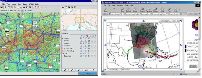
Some elements of the desired open standards-based fusion framework are pervasive now. The OGC Web Map Service (WMS) enables fusion of maps. WMS allows for maps as pictorial layers from different sources to be geographically-overlaid to create a composite map suitable to the user’s need (Figure 1).
Figure 1 - Examples of Fusion based on OGC WMS standard
Further development of the open-standards fusion framework is needed and is defined in the remainder of this ER. The results will include:
• Rapidly deployable interoperable tools to analyze, process and exploit two or more different types of data or products from the same or multiple sensors
• Develop new or further exploiting current capabilities for fusing information from, multiple sensors, multiple sources, and multiple INTs in ways that dramatically improve the ability to detect, identify, locate, and track objects.
Copyright © 2010 Open Geospatial Consortium 9
5.3 Phases of the Study
The OGC Fusion Standards Study was conducted in two phases that were linked with the OWS-7 and OWS-8 Testbeds:
• Phase 1 of the Study began with public announcement of a Request for Information (RFI-1). Ten organizations responded to RFI-1. An Engineering Report based on the RFI-1 responses was publically issued. [OGC, 2009]
• OWS-7 Testbed took up several of the recommendations from the Phase 1 Study ER (ER-1). The OWS-7 Testbed was conducted in 2010 and produced
implementations, demonstrations and Engineering Reports. OWS-7 focused on recommendations. OWS-7 results are summarized in this ER for Phase 2 study (ER-2) in particular regarding observation fusion and feature fusion.
• Phase 2 of the Study included an RFI for Decision Fusion, Responses to the RFI, a two-day workshop and this ER. The workshop was - hosted by Intergraph Corporation – was held on August 10 and 11, 2010.
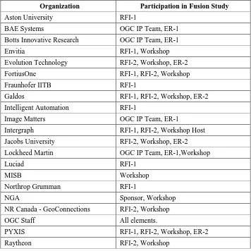
10 Copyright © 2010 Open Geospatial Consortium Twenty-one organizations participated in the Fusion Standards Study (Table 1).
Participation included responding to a Request for Information (RFI-1, RFI-2), contributing to an Engineering Report (ER-1, ER-2), participating in the Workshop in Phase 2, being a member of the OGC interoperability team for the study (IP Team) and sponsoring the study (Sponsor)
Table 1 – Organizations participating in Fusion Standards Study
Organization Participation in Fusion Study
Aston University RFI-1
BAE Systems OGC IP Team, ER-1
Botts Innovative Research OGC IP Team, ER-1
Envitia RFI-1, Workshop
Evolution Technology RFI-2, Workshop, ER-2
FortiusOne RFI-1, RFI-2, Workshop
Fraunhofer IITB RFI-1
Galdos RFI-1, RFI-2, Workshop, ER-2
Intelligent Automation RFI-1
Image Matters OGC IP Team, ER-1
Intergraph RFI-1, RFI-2, Workshop Host
Jacobs University RFI-2, Workshop, ER-2
Lockheed Martin OGC IP Team, ER-1,Workshop
Luciad RFI-1 MISB Workshop
Northrop Grumman RFI-1
NGA Sponsor, Workshop
NR Canada - GeoConnections RFI-2, Workshop
OGC Staff All elements.
PYXIS RFI-1, RFI-2, Workshop, ER-2
Co
6
Definition and Categories of Fusion
Data Fusion as defined for this study is:
“Fusion is the act or process of combining or associating data or information regarding one or more entities considered in an explicit or implicit knowledge framework to improve one’s capability (or provide a new capability) for detection, identification, or characterization of that entity” [OGC, 2009].
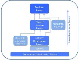
Three categories of data fusion (Figure 2) were used to organize the study: 1) Observation (sensor) Fusion,
2) Object/Feature Fusion, and 3) Decision Fusion.
A fundamental notion in any type of data fusion is the construction of associations between one or more data elements. In many cases this association may also involve additional processing and abstraction and result in a new type of data element. This notion leads to categories of data fusion based on the type of the data elements being associated: fusion of observations, fusion of features/objects, and fusion of decisions. Typically “sensor fusion” has been used to label the fusion of observations. Observation fusion is more accurate and is the preferred term going forward. Object/Feature Fusion is more problematic as the two terms have different meanings in the historically separate domains of image processing and GIS.
Multiple organizations and authors have offered categorization schemes for fusion. The three categories used in this ER have been found in publications extending back to 1974 [Wald, 1998]. For example these fusion categories was used in [Dasarathy, 1994]. Other approaches to fusion categories – in particular the JDL approach – are discussed later in this document.
Figure 2 – Fusion Categories
12 Copyright © 2010 Open Geospatial Consortium Definitions for the three categories of Fusion used in this Engineering Report are:
• Observation (sensor) Fusion: Fusion processes involve merging of multiple sensor measurements of the same phenomena (i.e., events of feature of interest) into a combined observation; and analysis of the measurement signature. Fusion ranging from sensor measurements of various observable properties to well characterized observations including uncertainties.
• Object/Feature Fusion: includes processing of observations into higher order semantic features and feature processing. Object/feature fusion improves
understanding of the operational situation and assessment of potential threats and impacts to identify, classify, associate and aggregate entities of interest.
Object/feature fusion processes include generalization and conflation of features.
• Decision fusion: the act or process of supporting a human’s ability to make a decision by providing an environment of interoperable network services for situation assessment, impact assessment and decision support, using information from multiple sensors, processed information, e.g., multi-INT sources.
These categories of fusion are useful but are not completely distinct. Assigning a fusion process to a specific category is done as a convenience for explanation in this
Copyright © 2010 Open Geospatial Consortium 13
7
Summary of Recommendations
7.1 Basis for Recommendations
The summary of recommendations presented here is drawn from the other sections of the ER. The basis for the recommendations is contained in the sections for each fusion category. Several of the recommendations are annotated with “(Phase 1)” indicating that the recommendation was made in Phase 1 of the Fusion Study and have yet to be acted upon. Many of the Phase 1 recommendations were investigated in the OWS-7 Testbed and do not appear here as they were in Phase 1.
7.2 Decision Fusion
8.5.1 Develop Decisions as First Class Objects in an Inform tion M delo 8.5.3 Standardize methods for Information Sharing between clients.
a 8.5.2 Develop a design pattern relating events and decisions
8.5.4 Promote diversity of interoperable Fusion Analyst Components
8.5.5 Develop registry for Decision Fusion, e.g., using ebRIM.
8.5.6 Develop open standards for visualization relevant to fusion
8.5.7 “See and Talk” collaboration with common geographic view
8.5.8 Coordination through social networks
8.5.9 Conduct a Decision Fusion initiative: Decision Fusion Pilot
7.3 Object/Feature Fusion
9.4.1 Develop WPS Profiles for Geoprocessing Fusion 9.4.3 Develop approaches for fusing “unstructured” data
9.4.2 Further develop rule-based geoprocessing to an OGC Best Practice 9.4.4 Registries for Object/Feature Fusion
9.4.5 Adding geographic structure with OGC Georefer nced TJS
9.4.6 Further develop Authoritative Data Source Directory
e
9.4.7 Apply the OGC standards to Political Geography
9.4.8 Continue to improve methods for GML schema handling
9.4.9 Review Discrete Global Grid Systems with OGC
9.4.10 Develop semantic data models supporting feature fusion (Phase 1) 9.4.11 Standardize metadata for provenance and uncertainty (Phase 1)
7.4 Observation (sensor) Fusion
10.4.1 Coverage fusion based on WCS 2.0, WCPS and GML. 10.4.2 Further develop Events in the OWS Architecture 10.4.3 Motion Imagery and location – coordinated with MISB 10.4.4 Apply SWE to Mobile Internet
10.4.5 Further develop Secure Sensor Web 10.4.6 Registries for Sensor/Observation Fusion
10.4.7 Online community sanctioned definitions for sensor terms (Phase 1) 10.4.8 Harmonization of the process of precise geolocation (Phase 1)
14 Co
8
Decision Fusion
8.1 Introduction
The definition of decision fusion used in this study is:
Decision fusion is the act or process of supporting a human’s ability to make a decision by providing an environment of interoperable network services for situation assessment, impact assessment and decision support, using information from multiple sensors, processed information, e.g., multi-INT sources.
Decision Fusion provides analysts an environment where they can – using a single client interface – access interoperable tools to review, process and exploit multiple types of data or products from multiple sensors and databases. Decision Fusion includes the use of information from multiple communities, e.g., multi-INT, in order to assess a situation, and to collaborate with a common operational picture. A more detailed description of the decision fusion process, e.g., JDL and OODA models, is provided in Section 8.3.1. This study also considered more recent advances such as social networking to support decision fusion. Though the focus of the study is on military intelligence (“INT”), decision fusion is relevant to business intelligence, urban planning, and many other domains.
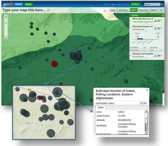
Figure 3 shows an example of decision fusion that goes beyond current Web Mapping Tools to associate trends and causes from multiple sources. In an Afghanistan election attack scenario (Figure 3) a likely target for an attack against the Pashtun during the 2009 election would be in Jalalabad, a largely Pashtun area with strong ties to Karzai, and a target of recent IED. The largest polling station in the area is at Compano Mosq, with an estimated 13,700 voters. An attack here on election day could impact the outcome.
Figure 3 - Decision Fusion Example (Source: FortiusOne)
Copyright © 2010 Open Geospatial Consortium 15
8.2 Enterprise Objectives for Decision Fusion
8.2.1 Decision Fusion Node
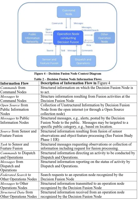
To structure the context for decision fusion, this study defines an “operations node conducting decision fusion”. External interfaces for a Decision Fusion Node are shown in Figure 4. Descriptions of each arrow on the context diagram are provided in Table 2. The Decision Fusion Node defined in this study is a scalable concept ranging from a person with a mobile computer to a Fusion Center such as the centers identified in the US ODNI Analytic Transformation [ODNI, 2008] and the Information Sharing Environment (ISE) Fusion Centers as operated by the US Department of Homeland Security [DoJ Global, 2008].
The Decision Fusion Node described in this section is intended to apply to a wide variety of situations ranging from local to international operations; from civilian emergency response to military command and control. Implicit in the concept of the Decision Fusion Node is the collaboration with other nodes, e.g., distributed decision fusion. Functions of a Decision Fusion Node are those steps necessary to perform a fusion process [DoJ Global, 2008], [ODNI, 2008], [Randol, 2009]:
1. Information collection and recognition of indicators and warnings
2. Situation Assessment: Processing and collation of information
3. Impact Assessment and Decision: Analysis and decision
4. Information dissemination: to associated nodes and to public networks
16 Co
Figure 4 – Decision Fusion Node Context Diagram
Table 2 – Decision Fusion Node Information Flows Information Flow Description of Information Flow in Figure 4
Commands from Command Nodes
Structured information on which the Decision Fusion Node is to act.
Messages to Command Nodes
Structure information resulting from Fusion activities at the Decision Fusion Node
Open Source from Public Information Nodes
Collection of Unstructured Information by Decision Fusion Node from the open internet (or through a Open Source collection node)
Messages to Public Information Nodes
Structured messages, e.g., alerts, posted by the Decision Fusion Node to the public. Messages may be targeted to a specific public category, e.g., based on location.
Source from Sensor and Feature Fusion
Structured information resulting from fusion of sensor
observations and object/feature processing (See Fusion Study Phase 1 ER)
Task to Sensor and Feature Fusion
Structured messages requesting observations or collection of information including request for fusion processing.
Commands to Dispatch and Operations
Structured information directing an activity to be conducted by Dispatch and Operations.
Messages from Dispatch and Operations
Structured information reporting on the status of activity by Dispatch and Operations.
Federated Search to Other Operations Nodes
Search requests to an operation node recognized by the Decision Fusion Node
Messages to Other Operations Nodes
Structured information transmitted to an operation node recognized by the Decision Fusion Node
Structured Data from Other Operations Nodes
Structured information received from an operation node recognized by the Decision Fusion Node
Co
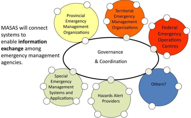
8.2.2 MASAS
The Multi-Agency Situational Awareness System (MASAS) initiative is a collaborative effort of Canadian emergency management agencies and content providers, co-led by GeoConnections and the Centre for Security Science, to develop a national capability for the exchange of geospatial emergency incident information. Based on open and
interoperable standards, the system will combine information from multiple sources to support decision-making through improved situational awareness for participating organizations. An opportunity exists to study the required standards, both existing and potential, for decision fusion processes within MASAS. GeoConnections responded to the Fusion Study Phase 2 RFI with the MASAS architecture.
The MASAS Architecture was developed in response to requirements from the public safety and security community. It has been used to design and deploy component
MASAS systems for Multi-Agency incident information sharing. The opportunity exists to expand MASAS to a number of other decision fusion applications such as the fusion of science-based emergency response information and cross-border information fusion. Additionally, the MASAS initiative could benefit from many of the study areas identified in the RFI-2 for fusion standards.
Figure 5 – Decision Fusion in a distributed environment (Source: NR Canada MASAS)
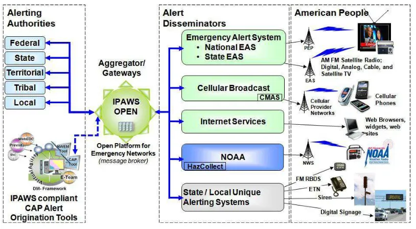
8.2.3 Integrated Public Alerting and Warning System (IPAWS)
IPAWS is designed to improve public safety through the rapid dissemination of emergency messages to as many people as possible over as many communications devices as possible. The US Department of Homeland Security FEMA is upgrading the alert and warning infrastructure so that no matter what the crisis, the public will receive life-saving information. In IPAWS, several project initiatives are using EDXL messaging technologies to enhance and expand the alerting capabilities available to emergency
18 Co
responders, incident managers, and public officials at all levels of government to inform and advise the public as shown in Figure 6.
• Common Alerting Protocol (CAP)
• EDXL Distribution Element (EDXL-DE)
• EDXL Hospital Availability Exchange (EDXL-HAVE)
• EDXL Resource Management (EDXL-RM)
Figure 6 - IPAWS Architecture
8.2.4 Enterprise Scenarios
8.2.4.1 Scenario: Connecting the Dots
This scenario considers connecting information held by several Decision Fusion Nodes in the determination of a plan of attack by an individual or small group.
This scenario is motivated by the “Christmas Day Attack” of 2009 when a terrorist onboard a flight bound for Detroit attempted to ignite a bomb attached to his body. Lessons learned from the attack included [Travers, 2010]:
• This incident does not raise major information sharing issues. The key derogatory information was widely shared across the U.S. Counterterrorism Community. The “dots” simply were not connected.
• The U.S. Government needs to improve its overall ability to piece together partial, fragmentary information from multiple collectors. This requirement gets beyond watchlisting support, and is a very complicated challenge involving both numbers of analysts and the use of technology to correlate vast amounts of information housed in multiple agencies and systems.
This scenario also considers the Nationwide SAR Initiative (NSI) that is designed to increase the amount of information—the intelligence “dots”—that will flow from state,
Copyright © 2010 Open Geospatial Consortium 19 local, and tribal law enforcement agencies to the federal government. The goal of
“connecting the dots” becomes more difficult when there is an increasingly large volume of “dots” to sift through and analyze. [Randol, 2009]
8.2.4.2 Scenario: Human presence detection through Multi-INT
Prior to committing personnel to investigate a building or suspicious site such as a cave, it is imperative to determine the importance and current danger of the site. This scenario aims to integrate information from multiple sources, i.e., multi-INT. The scenario will involve fusing information from sensors with cultural and human information about the area, and recent intelligence reports from human observers. [Thyagaraju Damarla, 2007], [ODNI, 2010]
This scenario will consider observing and characterizing the “human landscape” or “human terrain.” The scenario will also include quantification of the uncertainty and provenance in the decision fusion.
8.2.4.3 Scenario: Disaster Management
Actors for a Disaster Management scenario would be located at multiple command centers, each operating with different jurisdictions and perspectives.
• National/Regional/Local Command Centers
• Analytical Staff in support of Decision Maker
• Analytical staff that make recommendations.
• “on the scene” (in theatre) field personnel.
• Consumers and Producers of information.
A concrete example is EMS professional on site of a disaster, e.g., a major flood. Flood is reported to local command center – need ingress/egress routes and support vehicles to respond. Analyst looks at this request and determines possible routes, available resources etc to respond. Analyst makes recommendation to Decision Maker who dispatches resources to site. Which resources to send and what routes taken? Are the resources sufficient? May have “patients” at site(s) – what medical care is needed?
8.3 Information for Decision Fusion
8.3.1 Fusion Process Models
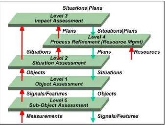
8.3.1.1 JDL Fusion Model
The JDL Fusion Model has a rich history of discussion (see for example [Eloi Bosse, 2007]). A revision of the JDL Model by [Steinberg, Bowman, & White, 1999] depicts typical information flow across the data fusion “levels.” JDL Level 0 and Level 1 correspond to the Sensor Fusion and Object/Feature Fusion. JDL Levels 2, 3, and 4 are relevant to Decision Fusion.
• Situation Assessment (Level 2): Perception of environmental elements within a
volume of time and space, the comprehension of their meaning, and the projection of their status in the near future. [Wikipedia, 2010]
• Impact Assessment (Level 3): process for considering the implications, for
20 Co
opportunity to modify (or, if appropriate, abandon) the proposals. It is applied at all levels of decision-making, from policies to specific projects. [IAIA, 2010]
• Process Refinement (an element of Resource Management) (Level 4): adaptive data acquisition and processing to support mission objectives. [Steinberg, Bowman, & White, 1999]
The terms Situation Awareness and Common Operating Picture (COP) are often conflated. Situation awareness is the combined product of perception, comprehension, and projection. COP is a combination of products of psyhcology, technology and integration processes. The conclusion of [Eloi Bosse, 2007] is that COP provides only a partial full situation awareness.
Processing of spatial, temporal, and semantic attributes of multi-source object metadata results in situation assessment. On the basis of a situation assessment an analysis of threats can be conducted. Solano and Tanik [Solano & Tanik, 2008] define an extension to the ISO 19115 metadata standard to capture the necessary metadata for a fusion framework which implements the Joint Directors of Laboratories (JDL) Data-fusion model.
Figure 7 – Refined JDL Data Fusion Model
8.3.1.2 Decision Models
Once Situation Assessment and Impact Assessment are accomplished, an operations node is well poised to consider decision and action. Again there is a rich history of research on decision-making models (See for example [Das, 2008]).
Decision fusion can be seen as the top of the information pyramid both in terms of information consumption and in terms of generating requests for new information. As Galdos identified [OGC, 2009], “Decision making is about making choices amongst alternatives (decision tree). It should be noted, however, that the set of choices might be
Co
quite dynamic and evolve in the course of an event (i.e. driven by the evolution of the event), or in an event independent manner. Decision makers want to learn from past mistakes (and are often also liable for their actions) hence the ability to automatically maintain an audit trail of decisions and their connection to particular feature and sensor information is critical.”
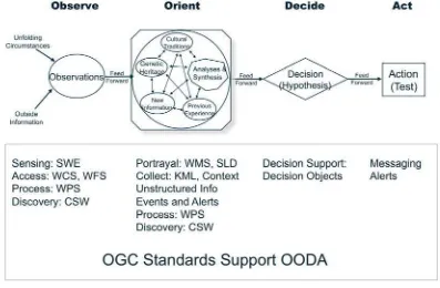
The OODA loop (for observe, orient, decide, and act) is a concept originally applied to the combat operations process, often at the strategic level in both the military operations. It is now also often applied to understand commercial operations and learning processes. The concept was developed by military strategist and USAF Colonel John Boyd. Any Internet search of Boyd and OODA will provide sources of all types on this topic. Figure 8 shows how current OGC standards support OODA. Observe and Orient are well supported by the current OGC standards baseline. Additional development and application of open standards is needed for Decide and Act, e.g., Decision Objects.
Figure 8 – OGC standards support of OODA
The OGC Fusion Study, Part 1 recommended that an information model be developed treating “Decision” as a first class object. The model needs to be done at abstract and implementation levels. The abstract model should define the attributes, operations and associations of a decision. For example a decision object should include an aggregation with decision trees, policies and audit trail. The decision object should include geospatial data and non-geospatial data. This abstract decision object should then be tested with real decisions from routine operational settings. Realizations of the decision should be made so that decision types can be used in registry and encodings defined for exchange.
8.3.1.3 Multi-INT information
Information available to an operations node is not just multi-source, but is from multiple intelligence collection types (multi-INT). Intelligence sources are people, documents,
22 Co
equipment, or technical sensors, and can be grouped according to intelligence disciplines (Table 3).
Table 3 – Multi-INT Sources [Joint Chiefs of Staff, 2007]
• Human intelligence (HUMINT);
• Geospatial intelligence (GEOINT), including Imagery Intelligence
• Signals intelligence (SIGINT);
• Measurement and signature intelligence (MASINT);
• Open-source intelligence (OSINT);
• Technical intelligence (TECHINT);
• Counterintelligence (CI).
Open source intelligence (OSINT) is a form of intelligence collection management that involves finding, selecting, and acquiring information from publicly available sources and analyzing it to produce actionable intelligence. In the intelligence community (IC), the term "open" refers to overt, publicly available sources (as opposed to covert or classified sources); it is not related to open-source software or public intelligence. Examples of multi-INT for an urban situation are shown in Figure 9. [Marco A. Pravia, 2008]. Information elements are placed in the table according to generating source (header row) and classification between hard and soft information (below and above the diagonal, respectively).
Figure 9 – Multi-INT examples for an urban situation
Copyright © 2010 Open Geospatial Consortium 23 Consideration of multi-INT in fusion is a basis for two major trends data fusion related to “soft” fusion. [Hall, 2008]
• First, the entities that we are interested in are no longer exclusively physical and may include events, patterns and activities. We are becoming interested in the location, identity, and interactions of individuals and groups (social networks).
• The second major trend in information fusion is the emergence of two new categories of information that have previously been relatively neglected; human observations and web-based information. With the advent of ubiquitous cell phones, personal data devices (PDAs) and mobile computing devices (with associated GPS, image sensors and on-board computing), we can consider formal and informal “communities of observers” that provide information about an evolving situation. (See Section 10.3.6)
8.3.2 Structured Information
8.3.2.1 Overview
Having discussed several models for fusion, the information used in those models is now considered in two broad categories: structured information, and unstructured information. Here structured information is defined to conform to structures, e.g., standards, defined by a community of practice. The categories of this section are inspired by the intelligence communities listed in Table 3. Some of the material in this section applies to Feature Fusion, but is described a single time here in the Decision Fusion section.
An outcome of the Decision Fusion Workshop was that OGC should continue to apply those standards that have been previously developed to the Decision Fusion topics. Existing OGC standards for structured information include the OGC Abstract Specification with focus on the Topics of Features, Coverages, Observations, and Geometry.
A conclusion of the Decision Fusion Workshop is that additional development is to be done on standards for structured information that support Decision Fusion both internal to OGC and with other standards bodies. For example, further work is needed on methods for schema mapping, e.g., identification of rules for mappings, and an increase in the focus on handling of Associations as the identification of an association between entities is at the heart of fusion.
8.3.2.2 Decision Information Standards
Decision-making is a topic that reaches beyond geospatial information. Decision fusion should be based on standards for decisions that have a general perspective. More work is needed to identify standards in this area.
8.3.2.3 Geographic and Imagery Information Standards
Standards for geographic and imagery information directly relevant to decision include the following:
• OGC Geography Markup Language (GML) Implementation Specification
24 Copyright © 2010 Open Geospatial Consortium
o Multiple GML profiles and applications schemas have been defined.
• OGC CityGML Implementation Specification
• OGC GML Application Schema for Coverages 1.0 Interface Standard
• OGC Symbology Encoding (SE) Implementation Specification
• OGC Geospatial eXtensible Access Control Markup Language (GeoXACML) Implementation Specification
• OGC KML Implementation Specification
• OGC GeoPDF Encoding Best Practice
• OWS-5 GEOINT Structure Implementation Profile (GSIP) Schema Processing Engineering Report
• OWS-5 Data View Architecture Engineering Report
• OWS-6 Urban Topographic Data Store (UTDS) - CityGML Implementation Profile ER
• ISO 19109:2005 – Geographic Information – Rules for application schema
• ISO 19115:2003 – Geographic Information – Metadata
o 19115-2:2009 – Geographic Information – Metadata - Part 2: Extensions for imagery and gridded data
o ISO 19139:2007 – Geographic Information – Metadata - XML schema implementation
• 19153 – Geographic Information – Geospatial Digital Rights Management Reference Model (GeoDRM RM)
• NATO Ground Moving Target Indicator Format (GMTIF
• Imagery encoding specifications: NITF, GeoPDF, GeoTIFF, HDF, NetCDF, LAS, SensorML, SWE Common
8.3.2.4 Human Reported Information Standards
Standards for human reporting of information directly relevant to decision include the following:
• OASIS Emergency Data Exchange Language (EDXL), including CAP
• OGC Event Pattern Markup Language (EML)
• NATO STANAG 2022 "Intelligence Reports”
• ISE Suspicious Activity Reports (SAR) (US Government specification)
• National Information Exchange Model (NIEM) (US Government specification)
• Army SALUTE reporting guidelines, 301-371-1000 (SL1) - Report Intelligence Information Standards
8.3.2.5 Emergency Data eXchange Language (EDXL) Messaging Standards
EDXL is a suite of XML-based messaging standards that facilitate emergency
information sharing between government entities and the full range of emergency-related organizations. EDXL standardizes messaging formats for communications between these parties. EDXL was developed as a royalty-free standard by the OASIS International Open Standards Consortium. EDXL standards support operations, logistics, planning and finance:
Copyright © 2010 Open Geospatial Consortium 25
• EDXL Distribution Element (EDXL-DE)
• EDXL Hospital AVailability Exchange (EDXL-HAVE)
• EDXL Resource Message (EDXL-RM)
• EDXL Reference Information Model (EDXL-RIM)
• EDXL Situation Reporting (EDXL-SitRep)
• EDXL Tracking Emergency Patients (EDXL-TEP)
• OASIS GML profile. (Also known as OASIS “where”)
The EDXL program is sponsored by the DHS Science & Technology Directorate, Office of Interoperability and Compatibility (OIC). Practitioner requirements and draft
specifications are submitted in partnership with the Emergency Interoperability
Consortium (EIC). Draft specifications emerging from this process are forwarded to the OASIS Emergency Management Technical Committee for consideration, vote and possible adoption as free, international, public XML-based messaging standards.
8.3.2.6 Signals intelligence standards
Standards for signals intelligence (SIGINT) directly relevant to decision include standards for alerts for tactically significant events and SIGINT identity information
8.3.2.7 Measurement and signature intelligence standards
Standards for measurement and signature intelligence information (MASINT) directly relevant to decision include standards for: alerts for tactically significant events and MASINT identity information
8.3.2.8 Political geography
The increasing interest in observing and characterizing the “human landscape” or “human terrain” using both conventional and emerging information sources motivated the
assessment of technologies related to understanding and modeling the new domains. [InnoVision, 2009]
Standards are needed for sharing of information in these key sub-areas: (1) human
landscape modeling technologies, (2) identifying and representing data imperfections and lineage, (3) modeling object data acquisition and management, (4) addressing moving objects – map merging and tracking, (5) understanding what data needs to be observed or collected, and (6) mapping observables to parameter needs of selected models.
8.3.3 Unstructured Information
8.3.3.1 Overview
26 Copyright © 2010 Open Geospatial Consortium understand a document may be very application related, so in some sense all data can be considered unstructured if used outside of its native application.
Since a great deal of information falls into this unstructured category there is interest in attaching new information to add structure or meaning to the content. Of course this is to be done where possible without changing the content itself. (This topic was discussed in the Phase 2 Workshop and reported in Section 9.3.1)
8.3.3.2 Open Source information
OSINT is based on publicly available information as well as other unclassified
information that has limited public distribution or access. Examples of OSINT include on-line official and draft documents, published and unpublished reference materiel, academic research, databases, commercial and noncommercial websites, “chat rooms,” and web logs (“blogs”).
8.3.3.3 OpenSource.gov
One source of consolidated OSINT is OpenSource.gov that provides timely and tailored translations, reporting and analysis on foreign policy and national security issues from the OpenSourceCenter and its partners. Featured are reports and translations from thousands of publications, television and radio stations, and Internet sources around the world. Also among the site's holdings are a foreign video archive and fee-based commercial databases for which OSC has negotiated licenses. OSC's reach extends from hard-to-find local publications and video to some of the most renowned thinkers on national security issues inside and outside the US Government. Accounts are available to US Government employees and contractors.
8.3.3.4 Metadata Extraction and Tagging Service (METS)
The Metadata Extraction and Tagging Service (METS) is a Department of Defense Intelligence Information System (DoDIIS) Core Service that extracts information found within unstructured documents. This promotes integration with structured data and will significantly improve search, analysis, and knowledge discovery. METS automates the normalization of, and extraction of information from, text documents, making the content of the documents quickly available as XML and OWL (Web Ontology Language) / RDF (Resource Description Framework) for intelligence analysis.
GML in METS is a conversion of a very small piece of the GML XML spec. It lumps together some small ontologies recommended by the W3C. It was supplemented by a few additional GML concepts used by DoD Discovery Metadata Specification (DDMS).
8.3.4 Information Integration
8.3.4.1 Linking
Copyright © 2010 Open Geospatial Consortium 27 OGC has developed draft proposed standards for linking unstructured information with geographic tags:
• Geolinked Data Access Service
• Georeferenced Table Joining Service (TJS) Implementation Standard
8.3.4.2 Tagging
Tagging of data from structured and unstructured sources is valuable towards integration of
• UCore
• Department of Defense Discovery Metadata (DDMS)
• Dublin Core
Tagging is done differently for hard versus soft sources. In hard fusion from a known sensor, tagging is often object attribution and feature characterization. While soft fusion must deal with increased uncertainty and provide basic context, e.g., location for hand-held photos, semantic labels for correlation, etc.
Geo-tagging is the process of attaching a location to an information element. There are multiple information structures for geo-tagging. Many of the geo-tags have been developed within specific communities.
• Standards developments for geo-tags
o OGC OpenLS Point of Interest
o IETF PIDF-LO
o URISA/FGDC US Street Address Data Standard
o ISO 19160, Addressing
o W3C Point of Interest Working group (proposed)
• Formats
o http://microformats.org/wiki/implementations
o Open formats: KML, GPS (waypoints), GeoRSS/GeoJSON
o Vendor formats: NAVTEQ, TomTom, TIGER
o Nokia Landmarks Exchange Format (2005)
o Yahoo: Where On Earth ID (WOEID).
8.3.4.3 Ontology Alignment
Current conceptual models for information fusion, including the JDL model do not consider the fact that their information sources are often based on different ontological bases. [Dorion, 2007] therefore suggests that the JDL model, which caters for space and time common referencing, be augmented with the notional aspect of common ontological alignment. Ontology alignment is the act of establishing a relation of correspondence between two or more symbols from distinct ontologies, for those symbols that denote concepts that are semantically identical, or similar.
Standards directly relevant to decision fusion for ontologies include:
• OWL
• RDF
28 Copyright © 2010 Open Geospatial Consortium Understanding a timeline events can be critical to Situation Awareness. Advanced Authoring Format (AAF) can be used to place various information elements into a
timeline. AAF was developed for the interchange of audio-visual material and associated metadata. While the original purpose of AAF is for video postproduction and authoring environment, AAF has been applied to fusion of multiple information sources regarding an actual timeline. [AMWA, 2010]
8.3.4.4 Uncertainty
Uncertainty propagation was a theme across all of the fusion categories discussed in the Phase 1 of Fusion Standards Study. Methods for propagating uncertainty into a decision framework are needed. Methods for presenting uncertain information in human-machine interface are needed. Communicating uncertain information to users is a non-trivial task and must build upon the results of on-going research. Development of this topic should begin with a “hard fusion” topic, i.e., a topic for which the uncertainty can be calculated from input uncertainty values.
• Uncertainty Markup Language (UnCertML) – OGC Discussion Paper
8.4 Services for Decision Fusion
8.4.1 Service-Oriented Architecture
The most effective environment for accomplishing the various types of fusion is expected to be a network-centric architecture with distributed databases and services based on a common core of standards-based data formats, algorithms, services, and applications. Such an environment allows the various forms of information to be collected, stored, managed, fused and disseminated vertically (from international to individual level) and horizontally (peer to peer).
A fusion environment involves people, processes, data, and technology that combine functional information with information about space and time (Figure 10). This means combining information from ISR, C2, planning assets, and multi-INT in space and time in order to assemble, relate, and coordinate relevant information from a variety of disparate sources and to provide a common situational understanding and a cohesive set of decision solutions.
In the conceptual fusion environment depicted in Figure 10, there are aggregator, processor and viewer services supporting collecting and consolidating, generating and synthesizing, and viewing and filtering activities, respectively. Information flows in various raw, processed, and fused representations into the fusion environment via network linkages enabled by connections between external source nodes and
Co
Figure 10 – Fusion Services Environment
8.4.2 Service Platforms
Services may be deployed using multiple technologies, e.g., REST, SOAP, and JAVA. The OGC recommends development of service oriented architecture standards using platform-independent abstract specifications and platform-dependent implementation specifications for all OGC service standards that support both procedure-oriented and resource-oriented service styles or patterns.
8.4.3 Services
8.4.3.1 Overview
The section identifies standards relevant to the services and components identified in the service-oriented architecture of the previous section. Services for data fusion were a topic during the Phase 2 Workshop with one result being Figure 10. On the right-side fo the figure are listed the types of services in which OGC has established a mature baseline of open standards. The left side of the figure considers services that are beyond the scope of just OGC. A key part of Decision Fusion is the ability to bring these two sides
together. For example most data has a location component but many times this location information is implicit. In order to make associations based on location, the non-geo data needs to be geotagged and associated with the rich stores of geographic information resulting in a new level of understanding based on the new associations.
30 Co
Figure 11 - Mind Map of Decision Fusion Services
8.4.3.2 Messaging: Alerts and Events
Much exchange of messages in a fusion environment is done using e-mail. These messages relate to specific events and are also used for planning and requirements Alerts are structured information intended for immediate human attention. Alerts maybe passed by e-mail and more specialized services defined for SOAP and REST
environments.
Events are structured information but not necessarily intended for immediate human attention. Events maybe passed by e-mail and more specialized services defined for SOAP and REST environments. OGC has defined events services for sensor related services. [Everding, 2009]
In addition to direct exchange of messages from producer to consumer, the publish/subscribe pattern allows for looser coupling of the source and receiver of messages.
In the SOAP oriented, “*” world, publish / subscribe can be handled with WS-Notification [OASIS, 2006]. WS-WS-Notification makes use of notification topics, which support a mix of the subscription models channels and types.
Instant messaging approaches may be considered for message passing. XMPP is a standard for XML message streaming. Various commercial vendor solutions for instant messaging also exist.
Methods based on open standards are needed to quickly communicate situation conditions and response of decisions makers to a large number of people in a specific geographic region. These announcements need to be coordinated though standards from a variety of communities, e.g., emergency response community using CAP and EXDL-DE. Methods involving dynamic high-speed routing of alerts to geographic regions are needed. This notification needs to include the available data (maps, digital data, imagery) based on geographic area of interest
![Table 3 – Multi-INT Sources [Joint Chiefs of Staff, 2007]](https://thumb-ap.123doks.com/thumbv2/123dok/3209519.1393935/27.612.97.510.421.639/table-multi-int-sources-joint-chiefs-staff.webp)