Vol. 1, No. 1 (2017): International Journal of Disaster Management - 1
Disaster Related to Mining: Causes, Impact, and Lesson Learned
Euis Sunarti, Hadi Sumarno, Dadang Rahmat Nugraha, Intan Islamia
Center for Disaster Studies, Bogor Agricultural University (IPB), Indonesia Contact:
Pusat Studi Bencana LPPM IPB Kampus IPB Baranangsiang, Jl Pajajaran Bogor
Abstract
This qualitative-descriptive study aimed to analyze the relationship among risk reduction, natural resource management and poverty as part of Sustainability Development Goals (SDGs) indicators. This research is part of a mandate research from government (Penelitian Unggulan Perguruan Tinggi) which raised the case of illegal gold mining (PETI: Penambangan Emas Tanpa Izin) in Merangin Regency. Primary and secondary data were being analyzed using content analysis and DPSIR. Results showed that illegal mining along the river moves from upstream to downstream and cause an increase in catastrophic events. Absence of law enforcement and disaster risk reduction contributed to environmental damage and increasing intensity of floods and flash floods. Disaster managers have not even performed disaster risk analysis, therefore it is still far to get to its integration with the achievement of SDGs.
Keywords: Disaster, integration, risk reduction, SDGs,
Introduction
Data of disasters in Indonesia showed that more than a thousand disasters occurred in the first half of year 2015. As of January till June 2015, recapitulation data from Indonesian National Disaster Management Authority (BNPB) showed that there were 1,082 of disasters, 141 people died and disappeared, 617,145 people lives and displaced suffer, and 9,556 units of houses damaged (BNPB, 2015). The disasters are not only caused by nature, but also because of the human factors. Even the largest percentage (70-80%) catastrophic events related to hydro-meteorological disasters (landslides, floods, erosion, drought) in which human factors had big shares. Disaster improves the vulnerability of families and communities because of the loss of family members, possessions, and led to potential crises related to uncertainty caused by the disaster. In addition, there is also an environmental damage caused by the disaster. A few example of disasters caused by human behavior are environmental degradation, floods, landslides, triggered as consequences of activities of illegal gold mining (PETI) in Merangin District, Jambi Province.
In Merangin District, illegal mining has been started since 2011 which is in Sub-District Pangkalan Jambu and then spread over several other districts, such as the Sub-District of Tabir Barat and Muara Siau. The economic condition of people enganged in PETI is increased, but on the other hand people are also beginning to feel the effects of environmental damage, such as river floods, floods, and landslides. The impact of disasters caused by PETI is felt by the communities, while illegal mining area continues to expand. Based on that, it is important to do studies in order to elaborate illegal mining management in relation with an increased risk in Merangin District.
Data and Methods
Vol. 1, No. 1 (2017): International Journal of Disaster Management - 2
data consists of perception and readiness of disaster management stakeholders on the importance of integrating Disaster Risk Reduction (DRR) with poverty reduction and land management gained from in-depth interviews and Focus Group Discussion (FGD). Secondary data consists of data related to natural disasters, environment, poverty, and efforts to overcome the risks of disasters which obtained from the concerned authority. Linkage of the various factors of the illegal gold mining and occuring disasters were analyzed using a DPSIR scheme (Driving force, Pressure, State, Impact, Response), which was first developed by the OECD (1994) and subsequently used by the United Nations (UNEP 1994; UNEP 2007) and the European Environmental Agency (Dutch National Institute for Public Health and the Environment 1995; Pierce 1998; EEA 1999).
Results and Discussions
Merangin District’s General Overview. Merangin District is the largest district in Jambi Province with an area of 7,679 km. This district consists of 24 sub-districts, 205 villages and 10 urban villages. In 2014, the district consist of 360,187 people with a density of 47 people per km. The district was drained by several rivers, including the Tabir River, Batang Merangin, Batang Mesumai, and Batang Telentam. Meanwhile, the community's economy relies on agriculture, forestry, hunting, and fishing (as much as 60 percent of people working in those sector). From the approximately 600,000 ha of agricultural land, approximately 49.8% is a plantation. The largest community-based plantation’s commodities in 2014 are palm oil (211,315 tonnes), rubber (61,360 tonnes), and coffee (6,577 tons). In terms of consumption, as much as 34.69 percent of Merangin population have an average expenditure per capita per month between Rp 300,000 and Rp 499,999 (Merangin in Figures, 2015). Fluctuations in the price of commodities since 2012 have an impact on instability and even declining people’s income in Merangin, so people tempted to do illegal mining (PETI) when a lot of investors coming from outside the district.
Vol. 1, No. 1 (2017): International Journal of Disaster Management - 3
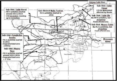
Figure1. Map of PETI Area Development in Merangin District
Source: Sunarti, et al. (2016)
PETI and Floods. Currently, people are being aware of the disaster caused by the activities of illegal miners. The community had complained about the overflowing river water to flooding, especially during the rainy season. From the upstream areas in the district, the streets which levels are higher than the river can be submerged up to more than a meter during the rainy season. Flooding, overflowing rivers, and erosion in the downstream region are taking place since PETI activities started in the upstream area. People in downstream area also complained about overflow of the water from the river due to a lot of PETI activities in the upstream area. The incidence of flooding in the downstream area increases along with the increased damaged area caused by PETI activities in the upstream area.
Since the PETI activities have existed, areas far from the banks of rivers which previously never have floods are now easily run into puddles around 20 to 30 cm just because of the drizzling rain. Recently, floods, flash floods, and landslides, occurred in several districts with PETI activities or affected area such as in the Sub-District Tabir Barat, Lembah Masumai, Tabir Timur, Tabir Ilir, Margo Tabir, and Nalo Tantan (Figure 1). For example, in the Sub-District Margo Tabir, in year 2016 there have been 17 times of flooding. Height of the flood in one of the villages hit as high as an adults neck, and in certain areas were reach up to 3 meters. Here are the details of flash flood disasters which occurred in Merangin District in 2012-2016.
Table 1. History of Flash Flood Disasters in Merangin District between 2012-2016
Date Location Impacts
February 2, 2012 Lebak Bumbun Village, Sub-District Margo Tabir Tanjung Ilir Village, Sub-District Tabir
466 houses were inundated as high as 1-1.5 meters, 1 SD submerged, two madrasah submerged, 2 pustu submerged
Early December,
2012 Lubuk Bumbun Village, Sub-District Margo Tabir Limau Manis Village, Sub-District Tabir Ilir
Lubuk Bumbun Village: in addition to the affected villages, there are 46 houses, 1 SD, 2 Madrasah and 1 pustu flooded.
Vol. 1, No. 1 (2017): International Journal of Disaster Management - 4 Tanjung Ilir Village,
Sub-District Tabir houses were flooded. Limau Manis Village: water up to 1 meter to 1.5 commemorate 49 housing units
February 5, 2013 5 village in Sub-District Nalo Tantan
• Dusun Mudp: 1 house heavily damaged • Muara Delang 4 houses were flooded • Ulak Makam 41 houses were flooded • Rt Limau Manis 165 houses were flooded • Ds. Rantau Tenang 60 houses were flooded
• Dsn. Kembang Bungo 158 houses were flooded
• Lebak Bento 30 houses were flooded • Padang Kelapo 70 houses were flooded • Sei Limau 318 houses, 4 mosque, 3 Puskesmas, 3 elementary school, 2 Madrasah were flooded
December 7, 2013 Tanjung Ilir Village, Sub-District Tabir
Limau Manis Vilalge, Sub-District Tabir Ilir
Sai Limau Village, Sub-District Tabir
- Sub-District Tabir : 11 houses were flooded
- Kec. Tabir Ilir : 129 houses were flooded - Kec. Tabir Timur : 56 houses, 1
elementary school, 1 Madrasah, 1 Puskesdes were flooded
January 12, 2014 Sub-District Tabir Ilir, Tabir
Selatan dan Tabir Timur The water level reached two meters. November 27,
2014 Kabu Village and Pematang Pau Village, Sub-District Sungai Tenang
Ds. Pematang Pau: 80 ha of rice fields damaged, Ds. Kabu: 20 hectares of rice fields damaged, 3 units of semi-permanent bridges washed away, one unit of a permanent bridge washed away, 6 units laluran secondary irrigation for MHP heavily damaged, 5 units mosque drift, and 1 buffalo drift
Mei 9, 2015 Sub-District Pangkalan Jambu 200 houses were flooded June 12, 2016 7 Village in Sub-District
Pangkalan Jambu
1 Village in Sub-District Sungai Manau
Around 414 houses and some general facility were flooded
February 6, 2016 Sub-District Bungo Three swept suspension bridge broke and damaged a primary school building unit as well as the destruction of agricultural land April 26, 2016 District Tabir Barat,
District Sungai Manau, Sub-District Tabir Ulu, Sub-Sub-District Tabir, Sub-District Tabir Ilir dan Sub-District Tabir Timur
6 districts, 23 Village,
Fatalities: 1 dead (drifting), 1 minor injuries (peck snakes), 9 houses were swept away, 32 were severely damaged, 7 houses were damaged, 2,820 houses were inundated, 23 schools, 23 religious facilities, 10 health facilities , 10 public facilities, 2 bridges, 3,168 meters of road, two box culvert, 146 m gabion, 1 MHP, 238 hectares of rice fields, 24.5 ha fields, 8 vehicles, 137 head of cattle, 11 ponds and 2,000 m of water channels
Vol. 1, No. 1 (2017): International Journal of Disaster Management - 5
are increasingly limited, then people move to utilize the land in the mountainous region both for farming and doing PETI activities. Nowadays, PETI activities has caused a catastrophic flash floods and landslides, even in certain areas drizzle raining alone is causing puddles which can reach up to 30 cm. Moreover, it caused the pollution of water. Although most people currently have regretted, but there are still groups of people who are still helping the sustainability of PETI activities.
In accordance to previous studies (Sunarti, et al., 2015), the analysis showed the linkage between patterns of living in the context of welfare and poverty prevention with the management of natural resources such as PETI by the community in the absence of law enforcement and disaster risk reduction. PETI activities are moving from the upstream area toward the downstream area in Merangin District. Meanwhile, when PETI activities are still located in the upstream area, downstream communities are already affected. If there was no effort of mining arrangements (groove, permit, recovery, and retribution for recovery) as well as post-mining recovery effort, we could predict an increase of the occurance and intensity of catastrophic disasters both in the upstream and downstream areas. Therefore, it is important to optimize the use of risk analysis and integrating it in the general(?) development, in this case including economic development, livelihood, and the environment. However, disaster managers in Merangin District still not knowing the importance of disaster risk analysis, they neither conducted an analysis of disaster risks nor implemented the analysis in regular development in order to achieve sustainable development goals.
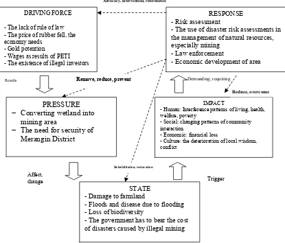
Figure 2. DPSIR Analysis of PETI Activities in Merangin District
DPSIR analysis (Figure 2) shows the interaction between humans and the environment in mining-related disasters in Merangin District, Jambi Province. The driving force of increasing
Demanding, requiring - The existence of illegal investors
RESPONSE - Risk assessment
- The use of disaster risk assessments in the management of natural resources,
- Human: Interference patterns of living, health, welfare, poverty
- Social: changing patterns of community interaction
- Economic: financial loss
- Culture: the deterioration of local wisdom, conflict
STATE - Damage to farmland
- Floods and disease due to flooding - Loss of biodiversity
- The government has to bear the cost of disasters caused by illegal mining
Vol. 1, No. 1 (2017): International Journal of Disaster Management - 6
PETI activities is the lack rule of law, felling price of rubber commodity, economy needs, potential of gold, as well as presence of investors both from inside and outside Merangin District. These cause the conversion of existing wetland into gold mining area. All of which have an impact on people's lives from the aspect of social, economic, and cultural. For example, interference in the patterns of living, health, welfare, poverty, changing patterns of community interaction, financial loss, and damage to local wisdom, and trigger a conflict. Therefore, the required response is by perform the disaster risk assessments then integrated in natural resource management, especially management of artisanal mining. The other thing is the rule of law and economic development of the region which provides a selection pattern of living for the people.
Conclusion
Study of linkage between disaster risk reduction of mining resource management and economic gains for welfare motives shows that there has been apparent linkage between efforts to obtain well-being through a pattern of living in order to avoid poverty with increased exploitation of natural resources which also increase the risk of disaster. Community exploited natural resources without considering the aspects of sustainability, safety, and sustainability. In Merangin District case, reflecting the movement of illegal mining activities from upstream toward downstream area, which affected all the communities. Therefore, substantial efforts on mining arrangements (groove, permit, recovery, and retribution for recovery) as well as post-mining recovery effort are needed. Furthermore, disaster risk analysis should play a role in preventing or reducing the risk of disasters which caused economic problems of society and the degradation of natural resources, but in fact that disaster management authority have not done the analysis of disaster risk due to not understand yet the purpose and its strategic position. This indicates an omission, especially if it is now they have been expected to integrate the disaster risk reduction with SDGs achievement.
References
Badan Nasional Penanggulangan Bencana. (2010). Rencana strategis badan nasional penanggulangan bencana tahun 2010-2014. Retrieved from http:// https://www.bnpb.go.id/uploads/migration/pubs/471.pdf/
Badan Perencanaan Pembangunan Nasional, Badan Nasional Penanggulangan Bencana. (2010). National action plan for disaster risk reduction 2010–2012. Retrieved from https://www.bnpb.go.id/uploads/migration/pubs/451.pdf/
Benson, C., Twigg, J. (2004). Measuring mitigation: methodologies for assessing natural hazard risks and the net benefits of mitigation, A scoping study: synthesis report. Retrieved from http://proventionconsortium.net/themes/default/pdfs/MM_synthesis-.pdf/
Benson, C., Twigg, J., Rossetto, T. (2007). Tools for mainstreaming disaster risk reduction: guidance notes for development organizations. Retrieved from http://www.preventionweb.net/files/1066_toolsformainstreamingDRR.pdf/
European Environment Agency. 2003. Europe’s environment: the third assessment. Retrieved from https://www.eea.europa.eu/publications/environmental_assessment_report-_2003_10/
Vol. 1, No. 1 (2017): International Journal of Disaster Management - 7
Osborn, D., Cutter, A., Ullah, F. (2015). Universal sustainable development goals. understanding the transformational challenge for developed countries. Report of a study by stakeholder forum. Retrieved from https://sustainabledevelopment.un.org/-content/documents/1684SF_SDG_Universality_Report_May_2015.pdf/
Sunarti, E. Hadi Sumarno, Syafruddin, Aliya Faizah Fithriyah. (2015). Laporan Penelitian Unggulan sesuai mandat pusat: pengintegrasian pengurangan risiko bencana dengan pencapaian SDGs. Bogor: PSB LPPM IPB
Sunarti, E. Hadi Sumarno, Dadang R. Nugraha, Intan Islamia. (2016). Laporan Penelitian Unggulan sesuai mandat pusat: pengintegrasian pengurangan risiko bencana dengan pencapaian SDGs. Bogor: PSB LPPM IPB
United Nations. (2015). The Millennium Development Goals Report 2015. Retrieved from http://www.un.org/millenniumgoals/2015_MDG_Report/pdf/MDG%202015%20rev %20(July%201).pdf./
United Nations International Strategy for Disaster Reduction. (2005). Hyogo framework for action 2005-2015: building the resilience of nations and communities to disasters.
Retrieved from
http://www.unisdr.org/2005/wcdr/intergover/official-doc/L-docs/Hyogo-framework-for-action-english.pdf./
United Nations International Strategy for Disaster Reduction. (2009). Global assessment report on disaster risk reduction: risk and poverty in a changing climate. Retrieved from https://www.unisdr.org/we/inform/publications/9413/
United Nations International Strategy for Disaster Reduction. (2015a). Kerangka kerja Sendai untuk pengurangan risiko bencana 2015-2030. (Platform Nasional PRB). Retrieved from http://www.bnpb.go.id/