Next Generation Radar (NEXRAD) is used to detect wind and precipitation to aid National Weather Service forecasters in predicting lash loods and other storms. The National Academies were asked to assess the availability, performance, and capability of the Sulphur Mountain NEXRAD in Southern California. The report concludes that it provides crucial radar coverage and is appropriately situated to assist the Los Angeles-Oxnard National Weather Service Forecast Ofice in forecasting and warning of lash loods. In general, NEXRAD technology is effective for lash lood forecasting in mountainous terrain but can be improved.
E
very year, floods are responsible for more deaths nationwide than any other weather phenomenon. On average in the past 30 years, loods have caused more than 120 fatalities per year; of these, most were due to lash loods. From 1996 through 2003, the average number of lash lood events recorded nationwide was nearly 3000 per year. Although lash lood forecasting is improving due to better radar and satellite observations, lash loods continue to be among nature’s worst killers.The National Weather Service is responsible for detecting hazardous weather and warning the public in a timely, accurate, and effective way. Forecasting lash loods is especially challenging because forecasters must predict not only the occurrence of the event but also its magnitude. The amount of precipitation and
WhAT ARE NEXRADs?
Set up in the mid-1990s, the nationwide network of Next Generation Radars has greatly improved precipitation analysis. Today, there are more than 130 radars in the network including several in southern California. NEXRADs are active remote sensing systems that send out pulses of energy. If the radar energy strikes an object, such as a rain drop, the energy scatters and a small fraction is directed back toward the radar detector. The travel time, strength, and Doppler phase shift of the pulse are used to measure the size and motion of the rain drops which, in turn, gives wind and rain rate information.
The map shows coverage provided by the
Sulphur Mountain NEXRAD (KVTX) and 4 adjoining radars. Source: Witold
Krajewski
Flash Flood Forecasting
Over Complex Terrain
With An Assessment Of The
Sulphur Mountain NEXRAD In
the time frame in which it occurs can transform an ordinary rainfall event into a deadly one. The creation and nationwide deployment of the Next Generation Radar (NEXRAD) has been instrumental in assisting forecasters with the detection and tracking of pre-cipitating systems, leading to improved lash lood forecasts and warnings.
The challenge of predicting flash floods is particularly great in regions with complex, or mountainous, terrain where there are sparse, intermittent surface-level observations. The radar beam can be partially or completely blocked in various directions by higher terrain. Placing the radar at a higher elevation or on a mountaintop may alleviate this problem, but may also cause the radar beam to overshoot lower terrain. This problem is exacerbated by the current restriction on the NEXRAD system limiting its minimum elevation angles to 0.5°. As a result, the precipitation intensity can be underestimated, or some precipitation may go undetected altogether.
SuLphuR MOuNTAIN RADAR IS EFFECTIvE AND AppROpRIATELy LOCATED
The Sulphur Mountain NEXRAD located north of Los Angeles in Ventura County, California, has been scrutinized in terms of its ability to detect precipitation events below 1.83-km (6000-ft) altitude and assist local National Weather Service meteorologists in lash lood forecasting. Thus, in February 2003, Senator Barbara Boxer of California, with support from the National Oceanic and Atmospheric Administration (NOAA), requested that the National Academies assess the effectiveness of operating NEXRADs in complex terrain—with a speciic analysis of the
Sulphur Mountain NEXRAD—to aid the NWS in forecasting heavy precipitation events and issuing lash lood forecasts, watches, and warnings.
After conducting a thorough analysis of the Sulphur Mountain NEXRAD, including the coverage provided by the radar and the performance of the Los Angeles-Oxnard Weather Forecast Ofice (LOX WFO) as measured by the lash lood warning statistics, the committee found little basis for concerns regarding the operational effectiveness of the Sulphur Mountain radar.
Low-Level Atmosphere Coverage Good
The ability to predict flash floods is greatly enhanced when radars can observe the low-level atmosphere in order to detect precipitation. To assess the extent to which the Sulphur Mountain NEXRAD is able to observe the low-level atmosphere, the committee conducted detailed calculations to assess the coverage provided by the radar. The calculations considered both the surrounding terrain—to determine if and where the radar beam is blocked by mountains— and the path of the beam through the atmosphere. The calculations show that the Sulphur Mountain NEXRAD provides greater coverage below 6000 ft than previously believed, making it appropriately sited to assist Los-Angeles in forecasting and warning of lash loods. (See Box 1)
Calculations were also completed to assess the coverage provided by the Sulphur Mountain NEXRAD compared to the adjoining Vandenberg Air Force Base, Santa Ana Mountain, Edwards Air Force Base, and San Diego NEXRADs (see map, p.1). As shown in the map, the radars provide overlapping coverage for much of the area, but the tan-shaded areas southwest of the Sulphur
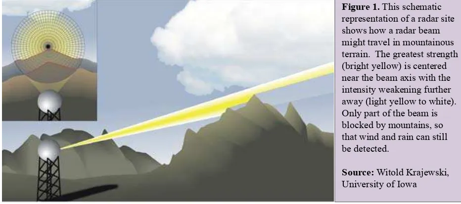
Figure 1. This schematic representation of a radar site shows how a radar beam might travel in mountainous terrain. The greatest strength (bright yellow) is centered near the beam axis with the intensity weakening further away (light yellow to white). Only part of the beam is blocked by mountains, so that wind and rain can still be detected.
Mountain radar over the Paciic Ocean are covered exclusively by the Sulphur Mountain radar. Because storms often approach from this area, additional low-level coverage for these areas would be beneicial for monitoring incoming storms and assessing their lash lood potential before they move onshore.
Los Angeles-Oxnard Weather Forecast Office’s Flash Floods Warning Record Excellent
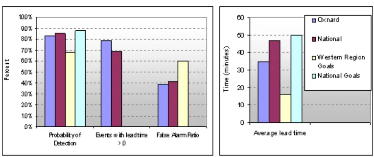
The LOX WFO’s lash lood warning statistics show that the ofice has an excellent record of issuing lash lood warnings. When the LOX statistics are compared to those of the other 115 WFOs throughout the continental United States, their record of accurately forecasting lash lood events with advance warnings, at 79 percent, is better than the national average value of 69 percent. The ratio of lash lood events in Los Angeles that were forecast but failed to materialize (called the false alarm ratio) is less than the national average. Finally, when compared with the 2004 goals of the National Weather Service Western Region, which are established by considering the complex terrain in the western United States and thus the greater tendency for rapid onset of lash looding, LOX WFO’s average lead time, percentage of forecast events, and false alarm ratio all are superior. (See Figure 2)
IMpROvING NATIONWIDE FLASh FLOOD FORECASTING
There are several ways to improve lash lood forecasting and warning, not only in Southern California and in other regions where NEXRADs are sited in complex terrain, but throughout the country. Box 1. Sulphur Mountain NEXRAD
Coverage Below 6,000 feet
To assess whether the Sulphur Mountain NEXRAD provides adequate coverage, particularly below 6,000 feet, the committee considered the full 3-D structure of its radar beam in calculations, not just the beam axis as was used in prior studies. The full 3-D structure includes not only the power concentrated at the center of the beam, but also the weaker part of the beam surrounding the center. (See Figure 7.2). This consideration is important because:
• even if part of the radar beam is intercepted by terrain, the remaining part of the beam still travels and can detect precipitation;
• the entire 3-D structure of the radar beam can sense precipitation, so when considering the lower half of the beam, the radar provides more coverage of the lower atmosphere than previously thought.
At its elevation angle of 0.5° upward, the main axis of the Sulphur Mountain radar beam rises above 1.83 km (6000 ft) altitude approximately 75 km away from the radar site. However, the lower half of the radar beam provides an additional 50 km of coverage below 6000 ft out to approximately 125 km away from the radar. Lowering the elevation angle would provide even greater coverage. These coverage and beam propagation calculations were done at every degree around the Sulphur Mountain NEXRAD site for radar beam elevations of 0.5°, 0.0°, and -0.5°. These calculations are available electronically from the National Acadmies at http://dels.nas.edu/basc/ nexradsm/radar_beam_and_terrain_viewer.html.
Figure 2. Flash lood warning statistics for the Los Angeles-Oxnard Weather Forecast Ofice compare favorably with national statistics for lash lood events from 1996 and 2003. The probability of detection is the fraction of the forecast events that occurred when forecast. The false alarm ratio is the number of events that were forecast but did not occur. Also shown for comparison sake are the 2004 national and Western Region goals.
Committee to Assess NEXRAD Flash Flood Forecasting Capabilities at Sulphur Mountain, California: paul L. Smith (Chair), South Dakota School of Mines and Technology, Rapid City; Ana Barros, Duke University, Durham, North Carolina; v. Chandrasekar, Colorado State University, Fort Collins; Greg Forbes, The Weather Channel, Inc., Atlanta, Georgia; Eve Gruntfest, University of Colorado, Colorado Springs; Witold Krajewski, University of Iowa, Iowa City; Thomas potter, University of Utah, Salt Lake City; Rita Roberts, National Center for Atmospheric Research, Boulder, Colorado; Matthias Steiner, Princeton University, New Jersey; Roger Wa-kimoto, University of California, Los Angeles; Julie Demuth (Study Director), Board on Atmospheric Sciences
and Climate; Elizabeth Galinis (Senior Program Assistant), Board on Atmospheric Sciences and Climate.
This report brief was prepared by the National Research Council’s Board on Atmospheric Sciencs and Climate. For more information, contact the Board at 202-334-3512 or visit http://www.national-academies.org/basc. Flash Flood Forecasting Over Complex Terrain is available from the National Academies Press,
500 Fifth Street, NW, Washington, DC 20001; 800-624-6242; www.nap.edu.
Permission granted to reproduce this brief in its entirety with no additions or alterations.
Copyright 2004 The National Academy of Sciences Enhancing Weather Radar Coverage
Low-level radar coverage is limited by the Earth’s curvature and blockage due to surrounding terrain. This is exacerbated by the current restriction of the NEXRAD system to minimum elevation angles of 0.5°. The use of lower, and perhaps even negative, elevation angles would allow monitoring of precipitation and wind at lower altitudes, providing a more representative assessment of near-surface rainfall. In addition, high-quality, real-time weather radar data are becoming more widespread. Making these data accessible to National Weather Service forecasters would increase the area and density of coverage of weather radar data, especially in regions of complex terrain. To enhance weather radar coverage, the National Weather Service should:
Improve nationwide NEXRAD coverage of low-level precipitation and wind, especially for elevated radar sites in complex terrain, through the adoption of a modiied scan strategy that will allow scanning at lower elevation angles.
Have access to all available regional real-time weather radar data including the Federal Aviation Administration (FAA) and Department of Defense NEXRAD radars; FAA Terminal Doppler Weather Radars and other surveillance radars equipped to provide weather-echo data; local television station Doppler radars; and operational radars from other organizations.
Consider augmenting the NEXRAD network with additional short-range radars to improve observation of low-level meteorological phenomena (e.g. rain, snow, wind).
•
•
•
Guiding Future Directions
Radars can observe the evolving weather systems that cause flash floods as they move into areas of concern, and future NEXRAD enhancements will improve the quality of those observations. The measurements of accumulating precipitation may not provide the most effective warning capability, but new and evolving techniques are available to improve this process. There also are gains to be made from rapidly evolving capabilities for better short-term and ine-scale forecasting, using regional and local numerical models that ingest real-time observations. In addition to these near-term improvements, consideration of hydrologic factors should be an integral part of future radar siting.
To increase the accuracy and lead time of lash flood forecasts and warnings, the National Weather Service should continue to implement new technologies and techniques including (a) the Flash Flood Monitoring and Prediction program at all Weather Forecast Ofices, (b) polarimetric modiications to NEXRAD, (c) data assimilation systems that integrate radar and other operational datasets into coupled hydrometeorological and hydrological models, and (d) data fusion systems.
In addition to the original NEXRAD siting considerations, future siting of radars in complex terrain should include detailed assessments of coverage in areas at risk for lash looding. •