DEVELOPMENT OF GPS DATABASE REPORT
Contract No. SSFFMP/rsgis/2006
SSFFMP AWP-IV Work Plan Number 4.1.2.6 and 4.2.6.2
Oleh :
Kata Pengantar
Peta dan Perangkat Global Position System (GPS) merupakan alat bantu yang
penting dalam kegiatan survey dan pemantaun titik Hotspot. Kemudahan dan
efisiensi pemanfaatan alat ini dapat menunjang kelancaran sistem pemantauan
kebakaran hutan yang dikembangkan oleh South Sumatera Forest Fire Management
Project (SSFFMP).
Oleh karena itu pembangunan database/peta GPS Garmin dan pelatihannya menjadi
salah satu kegiatan yang telah ditetapkan dalam rencana kerja project ini.
Tulisan ini berisi tentang laporan kegiatan yang telah diselenggarakan dalam bulan
April 2006 dan merupakan salah satu hasil dari kegiatan ini. Hasil lainnya adalah
Peta digital dalam format GPS Garmin yang siap digunakan meliputi wilayah
propinsi sumatera selatan dan panduan interaktif tentang cara pembuatannya
tersimpan dalam 1 buah DVD.
Pada kesempatan ini, Penulis panjatkan rasa syukur kepada Allah SWT, yang atas
ijin-Nya kegiatan ini dapat terselenggara dengan baik. Ucapan terima kasih kepada
Dr. Karl-Heinz Steinmann dan Dr. Dodi Supriandi selaku pimpiman SSFFMP yang
telah memberikan kesempatan kepada penulis sebagai konsultan. Juga kepada
Rekan Solichin, MSc dan team atas kerjasama dan bantuannya. Semoga tulisan ini
dapat bermanfaat bagi pihak-pihak yang ingin membuat peta dalam format GPS
Garmin.
Bogor, April 2006
Pembuatan Database Spatial Sumsel untuk GPS Garmin
Latar belakang
Global Position System (GPS) telah menjadi perangkat penting kegiatan survey
dan pemetaan. Penggunaannya telah meluas dengan berbagai tujuan dan aplikasi
dilapangan, dari GPS tipe geodetic untuk pembuatan peta dengan akurasi tinggi
hingga tipe handheld untuk navigasi dan orientasi lapangan. Seiring kemajuan
teknologi GPS, saat ini telah tersedia unit GPS yang telah terintegrasi dengan peta.
Fitur ini sangat bermanfaat bagi para pengguna, dimana titik lokasi gps akan
ditampilkan langsung sesuai dengan peta yang ada didalammnya. Namun
ketersediaan peta-peta dalam format GPS masih terbatas, baik skala maupun
cakupan areanya. Hal ini mendorong para pengguna GPS untuk membuat sendiri
peta-peta yang dimilikinya ke dalam format GPS, sehingga akurasi maupun
tematik peta dapat disesuaikan denga kebutuhan pengguna.
Kondisi ini melatarbelakangi South Sumatera Forest Fire Manajemen Project
(SSFFMP) untuk membangun peta sumatera selatan dalam format GPS Garmin
yang merupakan bagian rencana dalam AWP IV activity 4.1.2.6 dan 4.2.6.2.
Tujuan
Kegiatan ini bertujuan untuk menghasilkan Peta Sumatera Selatan yang dapat
diintegrasikan dalam unit GPS Garmin dan melatih stakeholder di dalam cara
pembuatannya. Sehingga suatu saat dilakukan pemutakhiran dan perbaikan
data, stakeholder mampu melakukan penyusunan ulang peta GPS.
Waktu Pelaksanaan
Kegiatan ini telah dilaksanakan pada bulan April 2006, selama 2 minggu.
Sedangkan kegiatan pelatihan untuk stakeholder diselenggarakan pada tanggal
11-12 April 2006 di Kantor SSFFMP Palembang.
Tahapan Kegiatan
Pelaksanaan kegiatan dilakukan dalam beberapa tahapan sebagai berikut:
1. Persiapan dan pengumpulan data-data tematik (dalam format shapefile ESRI)
Konsultan telah menerima data-data yang akan dikonversi menjadi peta GPS
Garmin dalam compact disc (CD) yang dikirim melalui pos.
Data tematik ini berisi lokasi kota, desa, kecamatan, kabupaten, jalan, sungai,
pos/regu pemadam kebakaran diwilayah kerja SSFFMP.
Konsultan juga membantu membelikan perangkat lunak (software) yang
diperlukan dalam kegiatan ini.
2. Konversi data shapefile ke dalam “Polish Format”dan membuat komposisi
peta dengan menggunakan software GPSMapedit.
3. Konversi data “Polish Format”menjadi format GPS Garmin dengan bantuan
software “cGPSmapper”.
Perangkat yang digunakan
Perangkat lunak (software) yang digunakan dalam kegiatan ini, terdiri atas:
1. GPSMapedit dari
http://www.geopainting.com
2. cGPSmapper dari
http://www.cgpsmapper.com
3. SendMap dari
http://www.cgpsmapper.com
Perangkat keras yang digunakan adalah computer desktop atau laptop dengan
operating system Microsoft Window, GPS Garmin yang memiliki fitur peta dan
kabel data yang menghubungkan GPS dengan komputer.
Hasil dan Rekomendasi
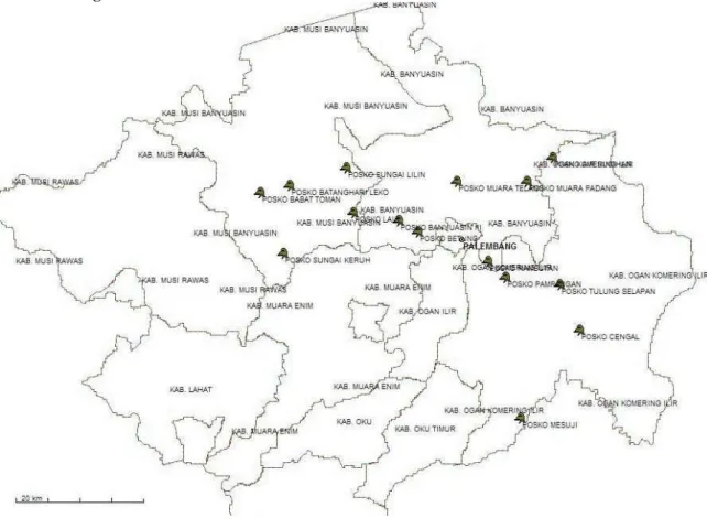
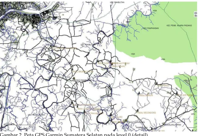
Produk utama dalam kegiatan ini adalah Peta Dasar Wilayah Sumatera Selatan
dan Informasi tematik yang disediakan oleh pihak SSFFMP antara lain titik-titik
lokasi posko kebakaran hutan. Adapun contoh tampilan peta yang dimaksud
terlihat gambar berikut ini:
Gambar 2. Peta GPS Garmin Sumatera Selatan pada level 0 (detail).
File digital peta GPS ini disimpan dalam 1 (satu) buah DVD, berikut panduan
cara membuatnya, data-data yang digunakan dan software-software yang telah
dikemukan pada uraian sebelumnya.
Selama kegiatan pelatihan berlangsung ada masukan dan rekomendasi dari
peserta agar diadakan pelatihan sejenis, namun difokuskan untuk membuat peta
dalam format GPS Magellan. Mengingat beberapa instansi (stakeholder)
Lampiran 1. Panduan Membuat Peta GPS Garmin
Slide 1
Membuat
Membuat
Peta
Peta
GPS
GPS
Garmin
Garmin
Oleh
Oleh
:
:
A. Salim
A. Salim
[email protected] [email protected] DisponsoriDisponsorioleholeh:: South
SouthSumateraSumateraForest Fire Management ProjectForest Fire Management Project
Palembang
Palembang––April 2006April 2006
Slide 2
KEYWORD
KEYWORD
Slide 3
[email protected] [email protected] SSFFMP SSFFMPPolish Format Map (PFM)
Polish Format Map (PFM)
*.mp
*.mp
Slide 4
[email protected] [email protected] SSFFMP SSFFMPLevel
Level
–
–
GPS Zoom
GPS Zoom
Slide 5
[email protected] [email protected] SSFFMP SSFFMPSoftware
Software
1.
1.
GPSMapEdit
GPSMapEdit
(
(
www.geopainting.com
www.geopainting.com
)
)
2.
2.
cGPSmapper
cGPSmapper
(
(
www.cgpsmapper.com
www.cgpsmapper.com
)
)
3.
3.
Sendmap20 (
Sendmap20 (
www.cgpsmapper.com
www.cgpsmapper.com
)
)
4.
4.
ArcView
ArcView
(
(
www.esri.com
www.esri.com
)
)
Slide 6
[email protected] [email protected] SSFFMP SSFFMPGPSMapEdit
GPSMapEdit
Slide 7
[email protected] [email protected] SSFFMP SSFFMPcGPSMapper
cGPSMapper
Slide 8
[email protected] [email protected] SSFFMP SSFFMPSendMap
SendMap
Slide 9
HOW ?
HOW ?
Slide 10
[email protected] [email protected] SSFFMP SSFFMPSlide 11
[email protected] [email protected] SSFFMP SSFFMPProses
Proses
1.
1.
Persiapan
Persiapan
input file (*.
input file (*.
shp
shp
)
)
2.
2.
Import file
Import file
dari
dari
SHP
SHP
ke
ke
PFM
PFM
3.
3.
Setting properties
Setting properties
cGPSMapper
cGPSMapper
4.
4.
Edit
Edit
objek
objek
5.
5.
Export file
Export file
dari
dari
PFM
PFM
ke
ke
IMG
IMG
6.
6.
Upload IMG
Upload IMG
ke
ke
GPS
GPS
Slide 12
[email protected] [email protected] SSFFMP SSFFMP1.
1.
Persiapan
Persiapan
Input File
Input File
Shapefile
Shapefile
sudah
sudah
memiliki
memiliki
proyeksi
proyeksi
peta,
peta
,
bisa
bisa
dalam
dalam
geographic
geographic
maupun
maupun
UTM
UTM
Bila
Bila
dalam
dalam
1
1
shapefile
shapefile
terdapat
terdapat
beberapa
beberapa
kelas
kelas
objek
objek
maka
maka
harus
harus
dibuat
dibuat
2
2
buah
buah
field,
field,
sbb
sbb:
:
o
o Field :Field :TipeTipe, 5, 5karakterkarakternumbernumber o
o Field :Field :LabelLabel, 16 ~ 80, 16 ~ 80karakterkarakterstringstring
Masukan
Masukan
nilai
nilai
“
“decimal/hexadecimal
decimal/hexadecimal”
”
kedalam
kedalam
kolom
kolom
field
field
“Tipe
“
Tipe
”
”
sesuai
sesuai
dengan
dengan
nilai
nilai
yang
yang
ada
Slide 13
SSFFMP
SSFFMP
Edit Table file SHP
Edit Table file SHP
Slide 14
[email protected] [email protected] SSFFMP SSFFMP2. Import file
2. Import file
dari
dari
SHP
SHP
ke
ke
MP
MP
Jalankan
Jalankan
program
program
GPSMapEdit
GPSMapEdit
Pilih
Pilih
menu FILE
menu FILE
Import
Import
ESRI
ESRI
Shp
Shp
(*.
(*.
shp
shp
)
)
Arahkan
Arahkan
ke
ke
lokasi
lokasi
direktori
direktori
file yang
file yang
akan
akan
di
di
-
-
import
import
Slide 15
[email protected] [email protected] SSFFMP SSFFMPImport
Slide 16
[email protected] [email protected] SSFFMP SSFFMP3. Setting properties
3. Setting properties
GPSMapEdit
GPSMapEdit
Masukan
Masukan
parameter
parameter
peta
peta
yg
yg
ingin
ingin
dibuat
dibuat
o o IDID o
o NameName o
o Copyright InformationCopyright Information o
o Elevation unitsElevation units o
o LevelsLevels o
o TRE sizeTRE size o o RGN limitRGN limit
Slide 17
[email protected] [email protected] SSFFMP SSFFMPSetting Map Properties
Setting Map Properties
Slide 18
[email protected] [email protected] SSFFMP SSFFMP4. Edit
4. Edit
objek
objek
Tentukan
Tentukan
“
“
Level
Level
”
”
Pilih
Pilih
objek
objek
atau
atau
komponen
komponen
peta
peta
yg
yg
akan
akan
di
di
edit
edit
Klik
Klik
kanan
kanan
Slide 19
[email protected] [email protected] SSFFMP SSFFMPEdit
Edit
objek
objek
Slide 20
[email protected] [email protected] SSFFMP SSFFMP5. Export
5. Export
menjadi
menjadi
file IMG
file IMG
Slide 21
[email protected] [email protected] SSFFMP SSFFMP6. Upload IMG
6. Upload IMG
ke
ke
GPS
GPS
Lampiran 2. Peserta Pelatihan dan Foto kegiatan
No Nama Instansi Alamat
1 Ashadi Bappeda Sumsel Palembang
2 Wijaya UNSRI Palembang
3 Firman Dishut Sumsel Palembang 4 Solichin SSFFMP Palembang
5 Radian BPKH II Palembang
6 Laut Tarigan SNRMC Palembang 7 Joko Pramono BPKH II Palembang 8 Crist Bappeda Sumsel Palembang
Lampiran 3. Jadwal Pelatihan
Tanggal Kegiatan Fasilitator Hari ke-1:
Selasa, 11 April 2006
9.00 – 9.30 Pembukaan dan Sambuatan Dr. Karl-Heinz Steinmann 9.30 – 12.00 Presentasi Pembuatan Peta untuk
GPS Garmin
Agus Salim 12.00 – 13.00 Istirahat
13.00 – 16.00 Latihan membuat Peta GPS Garmin
Agus Salim Hari ke-2:
Rabu, 12 April 2006
9.00 – 12.00 Latihan, Ujicoba lapangan dan Diskusi
Lampiran 4. Lisensi GPSMapedit
*************************************************************************** share-it! Order number: 23298396
**************************************************************************** This e-mail was generated by a mail handling system. Please do not reply to the address listed in the "From" field.
Please read the CUSTOMER SERVICE section for answers to your questions. ****************************************************************************
We recommend that you make a backup copy of this e-mail (e.g. print out a hard copy).
Dear Customer,
Thank you for your order. share-it! processes orders and collects payments on behalf of Konstantin Galichsky.
**************************************************************************** Contents:
A. Brief information on product delivery B. Details for product delivery for GPSMapEdit C. Technical Support
D. Customer service
**************************************************************************** A. Brief information on product delivery
Use the license key to unlock the product (see below). Please note that you will not receive a delivery by postal mail. **************************************************************************** B. Details for product delivery for GPSMapEdit
The product is licensed to "South Sumatra Forest Fire Management Project". The license key for "GPSMapEdit" is listed below. You will need this
license key to complete the process and activate the product. The license key and the text below originate from the software publisher and may be written in another language.
The License Key is:
60204-63F6004A-8C5A-B401-6A18A6DF
To activate the license, please run GPSMapEdit, follow menu 'Help | Activate license...', type "60204-63F6004A-8C5A-B401-6A18A6DF" to the 'License key' field and click the button "Obtain activation key
automatically via Internet". If all is OK, the string "not registered" in the title of the program will disappear.
**************************************************************************** C. Technical Support
If you have any content-related or technical questions about the product, please contact Konstantin Galichsky directly.
You can contact the publisher at the following e-mail address: [email protected]
**************************************************************************** D. Customer service
Questions about your order, payment, or delivery?
Answers to the most frequently asked questions / Contact: http://www.shareit.com/ccc/?languageid=1&pid=23298396 Your order data:
https://secure.shareit.com/shareit/ccc/my_account.html?languageid=1&pid=23298396 Viewing PDF documents:
You can download Adobe Reader free of charge from the following location: http://www.adobe.com/products/acrobat/readermain.html
Sincerely,
Your share-it! Team
____________________________________________________ share-it! - a service of digital river
Lampiran 5. Lisensi cGPSmapper
**************************************************************************** share-it! Order number: 48930145
****************************************************************************
This e-mail was generated by a mail handling system. Please do not reply to the address listed in the "From" field. Please read the CUSTOMER SERVICE section for answers to your questions.
****************************************************************************
We recommend that you make a backup copy of this e-mail (e.g. print out a hard copy).
Dear Customer,
Thank you for your order. share-it! processes orders and collects payments on behalf of Stanislaw Kozicki.
**************************************************************************** Contents:
A. Brief information on product delivery
B. Details for product delivery for cGSPmapper standard without marine support
C. Technical Support D. Customer service
**************************************************************************** A. Brief information on product delivery
Use the license key to unlock the product (see below). Please note that you will not receive a delivery by postal mail. **************************************************************************** B. Details for product delivery for cGSPmapper standard without
marine support
The product is licensed to "South Sumatra Forest Fire Management Project". The license key for "cGSPmapper standard without marine support" is listed below. You will need this license key to complete the process and activate the product. The license key and the text below originate from the software publisher and may be written in another language.
******************************************************************************** Registration name:
South Sumatra Forest Fire Management Project
000017-4JWQV8-2Y1A44-GCJT7Z-RZW8B4-GC6M71-BUUJQ3-V27YHZ-VRN9YP-4MV0G4 ********************************************************************************
If the Software does not allow you to enter your Registration data, start it from the command line with parameter 'REGISTER' :
cGPSmapper REGISTER
**************************************************************************** C. Technical Support
If you have any content-related or technical questions about the product, please contact Stanislaw Kozicki directly.
You can contact the publisher at the Websitehttp://cgpsmapper.comfor technical support.
**************************************************************************** D. Customer service
Questions about your order, payment, or delivery?
Answers to the most frequently asked questions / Contact: http://www.shareit.com/ccc/?languageid=1&pid=48930145 Your order data:
https://secure.shareit.com/shareit/ccc/my_account.html?languageid=1&pid=48930145 Viewing PDF documents:
You can download Adobe Reader free of charge from the following location: http://www.adobe.com/products/acrobat/readermain.html
Sincerely,
Your share-it! Team ____________________________________________________ share-it! - a service of digital river