Open Geospatial Consortium
Submission Date: 2015-05-12
Approval Date: 2015-06-05
Publication Date: 2015-08-19
External identifier of this OGC® document: http://www.opengis.net/doc/DP/tiled-elev-ext-geopackage
Internal reference number of this OGC® document: OGC 15-039
Category: OGC® Discussion Paper
Editor: Jeff Yutzler
Envisioning a Tiled Elevation Extension
for the OGC GeoPackage Encoding Standard
Copyright notice
Copyright © 2015 Open Geospatial Consortium
To obtain additional rights of use, visit http://www.opengeospatial.org/legal/.
Warning
This document is not an OGC Standard. This document is an OGC Discussion Paper and is therefore not an official position of the OGC membership. It is distributed for review and comment. It is subject to change without notice and may not be referred to as an OGC Standard. Further, an OGC Discussion Paper should not be referenced as required or mandatory technology in procurements.
Document type: OGC® Discussion Paper Document subtype:
License Agreement
Permission is hereby granted by the Open Geospatial Consortium, ("Licensor"), free of charge and subject to the terms set forth below, to any person obtaining a copy of this Intellectual Property and any associated documentation, to deal in the Intellectual Property without restriction (except as set forth below), including without limitation the rights to implement, use, copy, modify, merge, publish, distribute, and/or sublicense copies of the Intellectual Property, and to permit persons to whom the Intellectual Property is furnished to do so, provided that all copyright notices on the intellectual property are retained intact and that each person to whom the Intellectual Property is furnished agrees to the terms of this Agreement.
If you modify the Intellectual Property, all copies of the modified Intellectual Property must include, in addition to the above copyright notice, a notice that the Intellectual Property includes modifications that have not been approved or adopted by LICENSOR. THIS LICENSE IS A COPYRIGHT LICENSE ONLY, AND DOES NOT CONVEY ANY RIGHTS UNDER ANY PATENTS THAT MAY BE IN FORCE ANYWHERE IN THE WORLD.
THE INTELLECTUAL PROPERTY IS PROVIDED "AS IS", WITHOUT WARRANTY OF ANY KIND, EXPRESS OR IMPLIED, INCLUDING BUT NOT LIMITED TO THE WARRANTIES OF MERCHANTABILITY, FITNESS FOR A PARTICULAR PURPOSE, AND NONINFRINGEMENT OF THIRD PARTY RIGHTS. THE COPYRIGHT HOLDER OR HOLDERS INCLUDED IN THIS NOTICE DO NOT WARRANT THAT THE FUNCTIONS CONTAINED IN THE INTELLECTUAL PROPERTY WILL MEET YOUR REQUIREMENTS OR THAT THE OPERATION OF THE INTELLECTUAL PROPERTY WILL BE
UNINTERRUPTED OR ERROR FREE. ANY USE OF THE INTELLECTUAL PROPERTY SHALL BE MADE ENTIRELY AT THE USER’S OWN RISK. IN NO EVENT SHALL THE COPYRIGHT HOLDER OR ANY CONTRIBUTOR OF
Contents
1. Scope ... 5
2. References ... 5
2.1 Normative References ... 5
2.2 Informative References ... 6
3. Terms and Definitions ... 6
4. Conventions ... 6
5. Process ... 6
6. Proposed Approach ... 7
7. Next Steps ... 7
8. Frequently Asked Questions ... 8
Annex A Proposed Extension Clauses ... 9
A.1 MIME Type ... 9
A.2 TIFF Encoding ... 9
A.3 Table Definitions ... 9
A.4 Table Values ... 10
Tables
Table 1 – gpkg_2D_gridded_coverage_ancillary Table Definition ... 9Table 2 – Updated Tile Matrix Set Table Definition ... 10
i.
Abstract
The GeoPackage Standards Working Group (SWG) presents a vision for storing tiled gridded elevation data in a GeoPackage.
ii.
Keywords
The following are keywords to be used by search engines and document catalogues. ogcdoc, OGC document, GeoPackage, elevation, tiles, TIFF
iii.
Preface
The GeoPackage Standards Working Group (SWG) has identified a need for the ability to store tiled gridded elevation data in a GeoPackage. This document describes the vision and proposed approach, which is an extension to the OGC GeoPackage Encoding
Standard. The SWG proposes to leverage the existing structure for raster tiles using TIFF files as the container for the elevation values themselves.
Attention is drawn to the possibility that some of the elements of this document may be the subject of patent rights. The Open Geospatial Consortium shall not be held
responsible for identifying any or all such patent rights.
Recipients of this document are requested to submit, with their comments, notification of any relevant patent claims or other intellectual property rights of which they may be aware that might be infringed by any implementation of the standard set forth in this document, and to provide supporting documentation.
iv.
Submitting organizations
The following organizations submitted this Document to the Open Geospatial Consortium (OGC):
Image Matters LLC
v.
Submitters
All questions regarding this submission should be directed to the editor or the submitters:
Name Affiliation
1.
Scope
The GeoPackage Standards Working Group (SWG) has identified a need for the ability to store tiled gridded elevation data in a GeoPackage. This capability will be used to support use cases such as the following:
Visualization
o 2D (hillshade, color relief, slope)
o 3D (supporting changing view angles and level of detail)
Analysis
o Viewshed and line-of-sight
o Cross-country mobility (off-road routing)
o Site suitability and planning (slope analysis such as helicopter landing zones)
o 3D geometry representations of features (ground-based, airspace) o Terrain association (associating images to mapped locations) o Augmented reality training
Ideally this capability will be relatively easy to implement and will be suitable for a wide variety of computing environments including the mobile/handheld computing
environment.
This document describes the vision and proposed approach, which is an extension to the OGC GeoPackage Encoding Standard. The SWG proposes leveraging the existing structure for raster tiles using TIFF files as the container for the elevation values themselves.
We acknowledge that the proposed approach will not support certain applications that require a high degree of precision and/or accuracy (e.g., targeting).
2.
References
2.1 Normative References
The following normative documents contain provisions that, through reference in this text, constitute provisions of this document. For dated references, subsequent
amendments to, or revisions of, any of these publications do not apply. For undated references, the latest edition of the normative document referred to applies.
OGC 12-128r10 OGC® GeoPackage Encoding Standard https://portal.opengeospatial.org/files/?artifact_id=56357
TIFF http://partners.adobe.com/public/developer/en/tiff/TIFF6.pdf
2.2 Informative References
GeoTIFF Format Specification Revision 1.0
http://www.remotesensing.org/geotiff/spec/geotiffhome.html
3.
Terms and Definitions
This document uses the terms defined in Sub-clause 5.3 of [OGC 06-121r8], which is based on the ISO/IEC Directives, Part 2, Rules for the structure and drafting of
International Standards. In particular, the word “shall” (not “must”) is the verb form used to indicate a requirement to be strictly followed to conform to this standard.
For the purposes of this document, the following additional terms and definitions apply.
viewshed1
the geographical area that is visible from a location
4.
Conventions
This sections provides details and examples for any conventions used in the document. Examples of conventions are symbols, abbreviations, use of XML schema, or special notes regarding how to read the document.
GPKG: GeoPackage. When followed by a number, this refers to a numbered requirement from the GeoPackage Encoding Standard.
5.
Process
The SWG developed the tiled gridded approach through a series of private and public interactions between March and May 2015. The SWG email list and teleconferences were the primary means of discussion and decision making. All decisions were made by the SWG as per OGC policies and procedures. A number of votes were taken to ensure that there was consensus.
Army Geospatial Center. (This working group brought together representatives from a number of U.S. Army programs with an interest in elevation data.) This public feedback helped us identify good ideas and reach consensus.
6.
Proposed Approach
The SWG proposes extending the existing GeoPackage Encoding Standard and to leverage the existing structure for raster tiles. The existing tile set tables3 are used as normal with the following changes:
A new value of “2D-gridded-coverage” is allowed in the “data_type” column of the “gpkg_contents” table.
Create a new table called “gpkg_2D_gridded_coverage_ancillary” as described in Table 1.
Add new columns to tile set description tables as described in Table 2 (we foresee these columns being used in other extensions which also leverage the tiles
approach). When used for elevation data the new columns have the following values:
o content: “tiled-elevation”
o ancillary_table: “gpkg_elevation_ancillary”
o ancillary_key: (foreign key to row in gpkg_elevation_ancillary)
Instead of JPEG or PNG files, elevation data is stored in TIFF files. These files are constrained as follows:
o Either 16-bit signed integer or 32-bit floating point o One sample per pixel
o LZW compression may be used
o No subfiles or internal tiles
Use ISO metadata (optional) to encode other details about the elevation data.
7.
Next Steps
The SWG proposes the following next steps:
Discuss this proposal in the broader community (outside the SWG itself) to reach a consensus on approach.
Plan and perform interoperability experiments that allow implementers the opportunity to develop compliant software and demonstrate its interoperability (this could be as part of OWS 12 or in an independent interoperability experiment or plugfest)
Document the extension as part of an updated version of the GeoPackage Encoding Standard or as a separate document
3
8.
Frequently Asked Questions
Q: What about GeoTIFF?
A: The SWG was just looking for a simple container to hold the elevation values. The geo-referencing is handled by the tile structure so GeoTIFF would have been redundant. TIFF is self-describing (a plus for many SWG members) but is otherwise a fairly simple format with broad API support (libtiff, etc.). Requiring GeoTIFF would have
significantly increased the cost and complexity of the approach. This approach is also consistent with other OGC standards such as Web Map Tile Service (WMTS).
Q: What about supporting other types of coverages?
A: The SWG foresees this approach being used for other types of coverages (for
Annex A
Proposed Extension Clauses
A.1 MIME Type
Req1 (extends GPKG 35, GPKG 36): A GeoPackage that contains a tile pyramid user data table MAY store tile_data in MIME type image/tiff. The content of the data table SHALL NOT be raster tiles as per the core specification and SHALL be described by an extension such as this one.
A.2 TIFF Encoding
Req2 (constrains TIFF Section 2): A TIFF file storing tiled gridded elevation data SHALL have one sample per pixel.
Req3 (constrains TIFF Section 2): A TIFF file storing tiled gridded elevation data SHALL have one of the following two data types: 16-bit signed integer (SSHORT – 8) OR 32-bit floating (FLOAT – 11).
Req4: A TIFF file storing tiled gridded elevation data MAY use the LZW compression option as per TIFF Section 13. Client applications SHALL support this option.
Req5 (constrains TIFF Section 2): A TIFF file storing tiled gridded elevation data SHALL NOT contain multiple images per TIFF file.
Req6 (constrains TIFF Section 15): A TIFF file storing tiled gridded elevation data SHALL NOT contain internal tiles as per TIFF Section 15.
A.3 Table Definitions
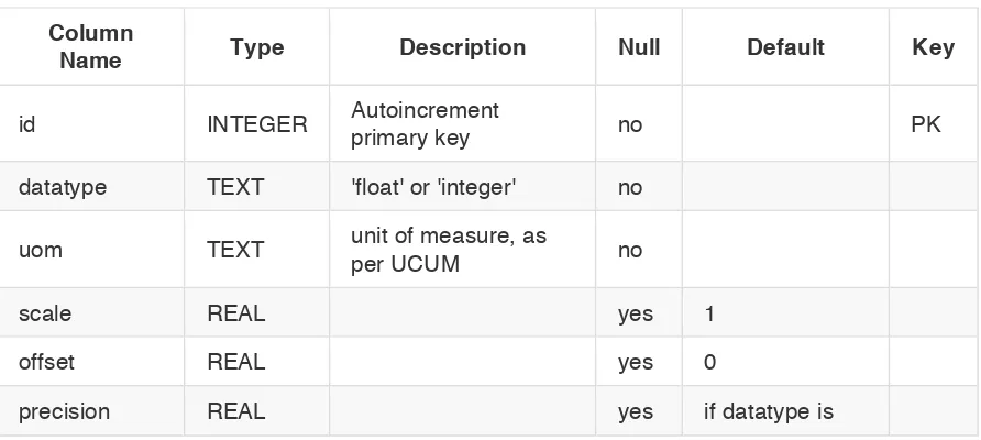
Req7: A GeoPackage that contains tiled gridded elevation data SHALL contain a gpkg_2D_gridded_coverage_ancillary table or view as per Table 1.
Table 1 – gpkg_2D_gridded_coverage_ancillary Table Definition
Column
Name Type Description Null Default Key
id INTEGER Autoincrement
integer then 1, otherwise undefined
data_null REAL yes
data_missing REAL yes
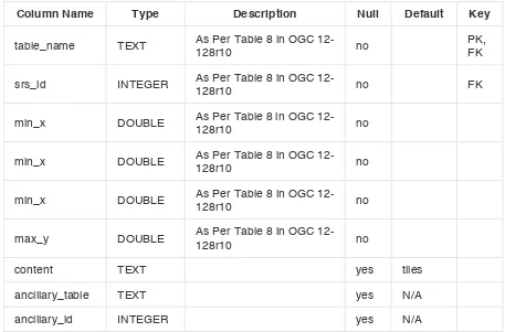
Req8 (extends GPKG 37): A GeoPackage that contains tiled gridded elevation data SHALL contain a gpkg_tile_matrix_set table or view as per Table 2.
Table 2 – Updated Tile Matrix Set Table Definition
Column Name Type Description Null Default Key
table_name TEXT As Per Table 8 in OGC
12-ancillary_table TEXT yes N/A
ancillary_id INTEGER yes N/A
A.4 Table Values
Req9 (extends GPKG34): The gpkg_contents table SHALL contain a row with a “data_type” column value of “2D-gridded-coverage” for each tile pyramid containing tiled gridded elevation data.
Req11 (extends GPKG40): For each tile pyramid user data table containing tiled gridded elevation data, rows in the gpkg_tile_matrix_set table SHALL contain values as denoted in Table 3.
Table 3 – Required Column Values in gpkg_tile_matrix_set
Column Name Value
content tiled-elevation
ancillary_table gpkg_2D_gridded_coverage_ancillary