Resource management domains: a biophysical unit
for assessing and monitoring land quality
Hari Eswaran
a,∗, Friedrich H. Beinroth
b, Surender M. Virmani
caUSDA, Natural Resources Conservation Service, Washington DC, USA bUniversity of Puerto Rico, Mayaguez, Puerto Rico
cInternational Crops Research Institute for the Semi-Arid Tropics, Hyderabad, India
Abstract
With the advent of information technology there is a renewed interest to define and identify homogenous food production systems. International donor agencies, such as the World Bank and the US Agency for International Development, are especially interested in public/private partnerships to develop and integrate information including the socio-economic/cultural contexts of farm systems to improve knowledge about food systems, nationally to globally. The International Agricultural Research Centers, non-government organizations and national institutions require a spatial–temporal–hierarchical information system describing farm systems and communities from the ‘nation to the farm’. Agri-business requires methods to evaluate the performance of crop systems in varied environments in countries and/or around the world.
As the society is stratified by different information needs, decisions must be made about the units of study and the hierarchy of information integration. The proposed hierarchy, developed on the tenets of hierarchy theory, implies that optimization of biodiversity, ecosystem health and integrity, commodity production, or maintaining soil quality, are each articulated based on the objectives that apply to the planning area. Management goals, therefore, determine the planning area to be defined, the goods and services, and the desired conditions of the ecosystem. Defined biophysical units, such as resource management domains (RMDs), serve as a common denominator for synthesis of information which could be shared by a range of disciplines, such as hydrology, geomorphology, pedology, crop science, economics, sociology, land-use planning, and production technology. In this approach, system dynamics or temporal variations are de-emphasized with the assumption that each RMD has attained an equilibrium or quasi-equilibrium within the planning horizon of the society. This is due to the practical purpose for which land resource assessments are generally made. However, if time periods of 50 or more years are considered, the concept must be refined. The latter approach is required for assessments of forest ecosystems. Published by Elsevier Science B.V.
Keywords: Resource management domains; Decision support systems
1. Introduction
There are many institutions in the world, including the World Bank, whose decisions and strategic plans are based on large quantities of reliable information. National institutions and decision-makers at all lev-els of society require similar or, sometimes more
∗Corresponding author.
site-specific, information for decision-making. With the advent of computer technology and the ability to process information rapidly, there is a concerted effort by scientists to refine the techniques of manipulating information. Land resource, and other, information, together with a decision support system, with proper spatial–temporal information, can be used to more specifically infer the potentials of the land system (Bouma et al., 1995), and consequently, to define
‘homogeneous management domains’ for food pro-duction systems around the world. Many international and regional donors and national institutions have been funding regional information systems through academic and non-profit communities to assist in characterizing food systems. The World Bank (Pieri et al., 1995), for example, is especially interested in public/private partnerships to develop and integrate information including the socio-economic/cultural contexts of farm systems to improve knowledge about food systems globally. The goal has always been to build a spatial–temporal–hierarchical information sys-tem describing farm syssys-tems and communities from the ‘nation to the neighborhood’ in each country, to link these to a region and, finally, enable a global assessment. Historical, natural and human managed inputs for and outputs of agricultural production systems within the socio-economic and environmen-tal landscapes need to be developed. Such systems will be based on the relatively data-rich resources of national government institutions.
While significant amounts of data have been col-lected already, we cannot directly (and democratically) collect all the information necessary to fully under-stand the complexities of natural or human driving fac-tors or the temporally and spatially varied responses of the food production systems. Orr (1998) has cau-tioned that, “We are drowning in unassimilated in-formation, most of which fits no meaningful picture of the world.” This, despite the statement of Cairns (1994) that “At best, only a primitive understand-ing exists of whole ecosystems — or landscape-level management.” In an environmental context, however, there is a continuing and increased need for not only the private sector, but the public sector as well, to better understand the impact of world populations upon the food-producing landscape. Many organizations have been independently collecting data, and are beginning to build true information systems for localized areas, data mining and modeling approaches, particularly of space- and time-extensive information that are only just now promising to provide critically needed insight into complex food systems. Certain information gen-erated by and for the use of private interests, from the individual precision farmer at the farm field level to large crop production corporations with global objec-tives, is intrinsic to such systems and must be protected through proven geo-commerce technique partnerships.
Multi-agency/multi-disciplinary public/private efforts are necessary to cost-effectively integrate and interpret needed information and no one organization is likely to succeed alone in such an endeavor. Data mining ap-proaches and inferencing engines require comprehen-sive, hierarchical, integrated information frameworks working with common denominators.
In developing countries, data collection is often more sporadic and usually incomplete (Kam and Oberthuer, 1998). Techniques to use fragmented infor-mation are rapidly being developed. This and related technologies are the key to a better knowledge about current and future food production areas at the homo-geneous domain level as they assemble facets com-prising the larger world. Utilities can be developed for such situations. Effective user interfaces will range from the simplest configurations through the most complex of structured query language (SQL)-driven commands that directly drive the utility (Maizel, 1998). Effective expression of utility analyses re-quires the highest capacity, internet-based information management technologies in the more ‘living’ and flexible digital world as accessed through interfaces. Rapidly exploding information needs of the research, education and private and public decision-making community are quickly demanding accessible, though off-site means for information access management and distribution. Products of such remotely accessible systems do not have to be large databases. They can range from simple GIF files (pictures down-loaded to a PC) through user fees and licenses to full-fledged, li-censed utility system spin-offs running in a very large server environment. With the advent of geographic information system (GIS) technology, development and manipulation of RMDs become more reliable. With GIS, spatial data can be linked to tabular data facilitating the use of SQL to generate new maps to assist in decision-making.
possible combinations and permutations is too large to handle but with reasonable assumptions, homoge-nous entities can be defined for most purposes. These are referred to as resource management domains (Du-manski and Craswell, 1998; Eswaran et al., 1998) and this paper looks at considerations for developing them to serve as basic units for LQIs.
2. Resource management domains
RMDs are geographic areas that are homogenous with respect to defined agricultural uses, have de-fined physiographic boundaries, and have similar land quality characteristics (Eswaran et al., 1998). In
data-sparse environments, such as developing coun-tries, soil resource inventories with some supporting climatic information are generally the only kinds of information available for characterizing the resource potentials of the nation or region. Depending on the land conditions and details of primary information, land quality within RMD may show large variations. RMDs can be created from such information and be-come the basis of analytical frameworks to estimate outcomes of alternative program delivery options; however, refining the RMD is a continuing task. In data-rich environments, such as the US and the de-veloped countries, using clustering techniques of a large number of parameters that impact the objective may attain similar goals. Even in these situations, a biophysical basis for designing RMDs has advan-tages as it provides a permanency in the resource assessment/characterization process. The land quality profile of such RMDs is generally homogenous for most agricultural uses. The RMDs may be split or clustered further if the objectives require refinement.
There must be permanency in RMDs for national resource inventories. The ability to analyze temporal information is as important as spatial information. Dumanski and Craswell (1998) have envisaged, “a
Resource Management Domain (RMD) as a spatial
(landscape) unit that offers opportunities for
iden-tification and application of resource management options to address specific issues. It is derived from geo-referenced biophysical and socio-economic in-formation, and it is dynamic and multi-scale in that it reflects human interventions in the landscape.” The
dynamic and multi-scale nature of the RMD
envis-aged by Dumanski and Craswell (1998) is a critical attribute, but fails to emphasize a most important function. In principle, one could create an RMD for each objective. Although this may satisfy immediate needs of the user, the ability to transfer information to other users for other purposes may be lost. Thus, RMDs to some extent must have the capability to serve multi-purposes and not just specific issues. A landscape based biophysical unit will not always meet this requirement and where it does not, RMDs can be split or grouped to meet these other needs. A land-scape based unit enables communication between all sectors of society, which becomes extremely impor-tant for land management legislation and transfer of technologies. An RMD must be amenable to be linked to other kinds of analysis. Crop simulation models, land management models, and any model that deals with ecosystems, require a unit of land to simulate the processes or conditions to back-stop decision support systems. The computing capacity, data availability, and the desired accuracy are variables that determine the size of the land unit. For pragmatic purposes, the unit must be sufficiently large to meet these require-ments — usually larger than polygons on detailed soil maps. A practical solution is usually clustering of map units. From the spatial/temporal associations among physical/environmental and known management fac-tors within an RMD, it is possible to infer by correl-ative means, domains in other parts of the country or the world where landscape and climate characteristics together with other crop-specific variables are similar. These other areas may lack the information for man-aging the land and by using default information from homologous RMDs, one can address the land manage-ment constraint. Such areas are expected to respond similarly to management within certain limitations of the knowledge base. Finally, RMDs must serve other purposes and particularly non-agricultural purposes such as agriculture census or even population census. An RMD is, hence, necessarily a biophysical unit demarcated on the landscape with available land-use and land-conditions information and becomes a per-manent feature in evaluating a nation’s land resources.
3. Defining RMD-based LQIs
a variety of users. Both national and local politicians are interested in targeting programs and determin-ing how well their objectives are met. Namdetermin-ing the RMD with a locality name or simple numeric codes is usually well received. Implementing agencies and decision-makers on land management programs must have the capability to determine how well these po-litical objectives are met. They also have to monitor progress and status so that corrective actions for not only the target RMD but also linked RMDs are known. They have to be accountable for spending public sector funds. The technical-scientific com-munity is interested in system processes and RMDs provide a sufficient homogenous entity to base their models. Finally, since RMDs are defined on biophys-ical characteristics, they become an entity to evaluate the socio-economic impacts on defined ecosystems.
The work of the Task Force on Land Quality Indi-cators of the World Bank has elucidated the concept of LQIs and discussions are underway for global as-sessments. The determination of dynamic changes of land quality is crucial to the development and imple-mentation of policies designed to ensure sustainable agroecosystems. A dynamic change in the conditions of land is a function of the cumulative changes of state of individual ecosystem attributes, throughout the period of interest. The change of an attribute from time zero to a new time period requires estimates of the reference state and the selection of an appropri-ate time frame for its measurement of change, and RMDs provide the land unit for such measurements. Resilience of the land is one way of evaluating soil management systems for degrading or improving processes. In systems where dLQI/dT is greater than zero, the system is sustainable.
The challenge for the scientist is to select LQIs that are significant indicators of the status and trends of agroecosystems quality and are related to the processes caused by various land management practices. Both qualitative and quantitative indicators have relevance:
• Qualitative indicators — those associated with rather easily observed changes occurring on the land. They are associated with day-to-day aware-ness and experiences. People observe changes in the crop performance; they detect salt crusts or sur-face sealing of soils; they note the sediment load in streams; they recognize declining yield trends, etc. What we should learn is how to utilize this
common knowledge in our efforts to scientifically backstop and develop quantitative indicators of sustainability of agroecosystems.
• Quantitative indicators — dynamic changes in agroecosystems must be science-based and should be capable of providing reliable assessments of the consequences of land management practices. Such indicators must rely on the scientific knowledge of relationships supported by theory and experimen-tation. It is a never-ending search for meaningful and practical ways of efficiently, and effectively, assessing and evaluating changes. The operational approach basically consists of (i) a careful selection of observation/test sites, (ii) setting up of validated standards, (iii) definition of ‘present’ base level status to serve as a ‘benchmark’, (iv) decisions on the periodicity of monitoring, and (v) setting up a framework for coordination of research and information gathering.
the concept must be refined. The latter approach is required for assessments of forest ecosystems.
In the last decade, much work has been done on land quality and soil quality. These are not synonyms as their assessment is based on scale of observation. In Table 1, the two lowermost units are referred to as resource management domains and farm recommen-dation domains, each having a range in scale within which each has most relevance. Land quality indica-tors (LQIs) are ideal to evaluate RMDs. Soil quality indicators (SQIs), due to the requirement for more de-tailed information on soil properties and conditions, are more appropriate for use in farm recommendation domains. For some purposes, LQIs and SQIs may be used outside their normal scale of usefulness. This is particularly true of LQIs, which can be used for smaller scales, such as major land resource areas.
For most practical purposes, the LQIs must have a monetary value attached or could be eventually evalu-ated in monetary terms. Although physical indicators can be collected, monitored and assessed for dynamic changes, it is essential to have real cost economics of the consequences of the land management practices.
4. RMD attributes and profiles
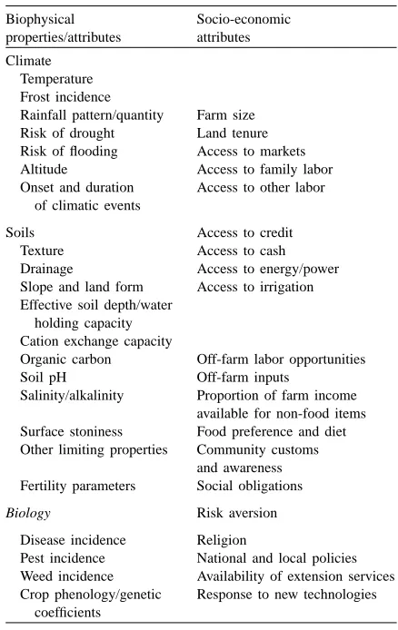
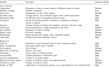
Variables considered for defining resource manage-ment domains (Eswaran et al., 1998) are presented in Table 2. The utility of each variable is determined by several factors including, availability of data on the attribute over a time frame, sensitivity of the data to changes being monitored, relevance of information to local situation, and statistical techniques to be em-ployed for processing information. For general land management purposes, each RMD can have a pro-file (Table 3) providing information on biophysical characteristics, land quality attributes and indicators sensitive to change, socio-economic features that enable aggregation of RMDs for socio-economic as-sessments, and other features that show the linkage of one to another. Although there may be a commonal-ity of basic information, location-specific information provides the unique features of the RMDs.
Aggregation of RMDs may be necessary for pur-poses such as those below:
• Crops are indicators of managed and natural envi-ronmental conditions. Clusters of RMDs for specific
Table 2
Variables considered for defining resource management and farm recommendation domains
Rainfall pattern/quantity Farm size Risk of drought Land tenure Risk of flooding Access to markets Altitude Access to family labor Onset and duration
of climatic events
Access to other labor
Soils Access to credit
Texture Access to cash
Drainage Access to energy/power Slope and land form Access to irrigation Effective soil depth/water
holding capacity Cation exchange capacity
Organic carbon Off-farm labor opportunities Soil pH Off-farm inputs
Salinity/alkalinity Proportion of farm income available for non-food items Surface stoniness Food preference and diet Other limiting properties Community customs
and awareness Fertility parameters Social obligations
Biology Risk aversion
Disease incidence Religion
Pest incidence National and local policies Weed incidence Availability of extension services Crop phenology/genetic
coefficients
Response to new technologies
crop (corn) production systems will enable an anal-ysis of the performance of this crop production sec-tor of the economy. Such an analysis is made using crop simulation models and RMDs are appropriate units to serve as the basis for such assessments. • Pests are indicators of crop growth conditions and
vice versa. RMDs using pests as indicators can be developed by inference from a series of observations on crop/pest associations. RMDs have the added advantage in being able to be used as a basis for extrapolation.
Table 3
General usefulness of some attributes to develop a profile of a RMDa
Attribute Descriptor General usefulness
Socio-economic
Urbanization Proportion of farms to towns; density of different classes of roads; Medium
Mobility of people Number of migrants Low
Social class Homogeneity in race, color, religion Medium
Economic status Average income; use of off-farm inputs; status symbol possessions High Educational status Of different sectors of population; literacy status High Occupation Extent of non-farm functions of farmers or proportion of off-farm
income of farmers
High
Transport Amount of kinds of vehicles for transport – bicycles, pick-ups, trucks High Family type Several generations or single generation in one house Medium
Age structure Proportion of adults in family Medium
Energy source For house, farming Medium
Infrastructure Water and electricity supply, roads, marketing facilities Medium
Land tenure Owned, leased and conditions of lease High
Biophysical
Land-use Proportion of land cultivated; kind of crops/ cropping systems High
Value of production Farm gate market value of produce High
Farm capacity Size of farms Medium
Social laws of land-use None to very rigid Medium
Soil quality In the context of farming system High
Land potential Current production to achievable levels High
Land-use configuration Context of ecosystem equity Low
Historical land-use pattern Changes in farming systems over defined periods Medium
Productivity trends Changes in yield over time Medium
Quality of SLM Application of conservation measure, use of agri-chemicals, use of hybrid seeds High
aRating: High-to-low, is locale specific.
Though RMDs may be aggregated for specific pur-poses, each RMD must have its own profile with its own set of attributes. Splitting or clustering of RMDs should not result in a loss of their individual identities.
5. Conclusions
The final geo-referenced RMD map of a country or region becomes the basis for several major assess-ments and can be linked to other databases to pro-vide answers for decision-making. Features of some of the products generated from the basic RMD maps and RMD profiles include:
• Broad public educational value. Information can be developed to illustrate this for the non-technical user using modern day, computer-driven visualiza-tion techniques.
• Have private as well as public value. Means for integrating corporate and farmers-specific informa-tion while protecting the private property interests of the partners must be explored.
• Have value to the private sector. To meet needs for marketing of effective and appropriate crop-production systems, the domains will be de-veloped according to parameters of known value to the corporations or farmer organizations.
• Serve as basis for national resource inventory, which determines the state and conditions of the resource base and using land quality indicators, to monitor changes in the conditions.
companies, and technology marketers would have an enhanced and more specific tool with which to promote products.
• Extend the land quality indicators (LQI)
applica-tions. The LQI is a unique and invaluable tool, and
when fully functional, it would have the capability for integration into new information systems. For some purposes, the LQI is a descriptor of the RMD by which preliminary assessments can be made for land-use planning.
References
Bouma, J., Kuyvenhoven, A., Bouwman, B.A.M., Luyten, I.C., H.G. Zandstra, 1995. Eco-regional Approaches for Sustainable Land-Use and Food Production. Kluver, Dordrecht, Holland. Cairns, J., 1994. The current state of watersheds in the United
States: ecological and institutional concerns. In: Proceedings of Watershed-93 — A National Conference on Watershed Management Alexandria, VA. US Forest Service publication, pp. 11–17.
Dumanski, J., Craswell, E., 1998. Resource management domains for evaluation and management of agro-ecological systems. In: Syers, J.K. (Ed.), Proceedings of Conference on Resources Management Domains, Kuala Lumpur. International Board for Soil Research and Management (IBSRAM), Proceedings 16, pp. 1–16.
Eswaran, H., Beinroth, F., Reich, P., 1998. Biophysical consi-derations in developing resource management domains. In:
Syers, J.K. (Ed.), Proceedings of Conference on Resources Management Domains, Kuala Lumpur. International Board for Soil Research and Management (IBSRAM), Proceedings 16, pp. 61–78.
FAO, 1993. An International Framework for Evaluating Sustainable Land Management. Food and Agriculture Organization, Report 73. Rome.
Grandstaff, T.B., 1992. The human environment: variation and uncertainty. Pacific Viewpoint 33, 135–144.
Kam, S.P., Oberthuer, T., 1998. Delineating resource management domains in highly variable and data-sparse environments. In: Syers, J.K. (Ed.), Proceedings of Conference on Resources Management Domains, Kuala Lumpur. International Board for Soil Research and Management (IBSRAM), Proceedings 16, pp. 225–244.
Maizel, M.S., 1998. The information utility. Internal discussion paper: A pilot project concept paper. National Center for Resource Innovations, Rosslyn, VA, USA.
O’Niell, R.V., DeAngelis, D.L., Wade, J.B., Allen, T.F.H. 1986. A Hierarchical Concept of Ecosystems. Princeton University Press, Princeton, NJ.
Orr, D.W., 1998. Speed. Conservation Biology 12, 4–7. Pieri, C., Dumanski, J., Hamblin, A., Young, A., 1995. Land
Quality Indicators. World Ban Discussion Papers, 315. World Bank, Washington DC, 63 pp.
Singh, V.P., Singh, A.N., 1995. Integration of different levels of rice ecosystems analysis. In: Fragile Lives in Fragile Ecosystems. IRRI. Manila, Philippines, 976 pp.