T
racking
and
P
redicTing
The
a
TmosPheric
d
isPersion
of
h
azardous
r
eleases
For many years, communities have prepared themselves to deal with accidental atmospheric releases from industrial sites, energy facilities, and vehicles transporting hazardous materials. Today, these communities must also worry about the terrorist threat of the intentional use of chemical, biological, and nuclear (C/B/N) agents. Because of this threat, the ability to predict and track the dispersal of harmful agents has become a critical element of terrorism planning and response.
Our nation’s capacity to respond to atmospheric C/B/N events stands, like a three legged stool, on the strength of three interconnected elements: 1) dispersion models that predict the path and spread of the hazardous agent; 2) observations of the hazardous plume itself and of local meteorological conditions, which provide critical input for the models; and 3) interaction with emergency responders who use the information provided by the models.
As part of the National Academies continuing focus on issues of homeland security, Tracking and Predicting the Atmospheric Dispersion of Hazardous Material Releases examines our nation’s current capabilities in these three areas and provides recommendations for strengthening them.
strengthening atmospheric models
In the minutes following the detonation of a dirty bomb or release of a chemical or biological agent in air, emergency responders must quickly ind answers to vital questions: what was released, how is the hazardous plume likely to spread, and how do we best help those in its path?
Predicting the path of a hazardous plume relies on sophisticated dispersion models that describe the movement of the plume in four dimensions—the three dimensions of space plus time. A comprehensive model takes into account the nature of the material released, the local topography, and local meteorological conditions. From this information, the model estimates risk parameters, most often expressed as likely dosages that could affect people near the release site and in areas downwind.
Dozens of dispersion models are currently in use, run by several federal agencies as well as academic and private sector research groups. The report does not provide a comprehensive analysis or intercomparison of these models, but instead looks at a subset of them (primarily those used by national agencies) that represents a range of capabilities and applications. While existing models meet some needs associated with threat assessment, preparation, and training, the report inds that these models may not fully meet the needs of responders in an actual emergency.
This is the scenario: At noon in Seattle, a hidden bomb explodes south of the central business district, causing more than
100 casualties. Signiicant levels of radiation are detected near the site of the explosion and it soon becomes apparent to local oficials that this was no ordinary bomb, but a radiological dispersal device,
commonly known as a “dirty bomb.”
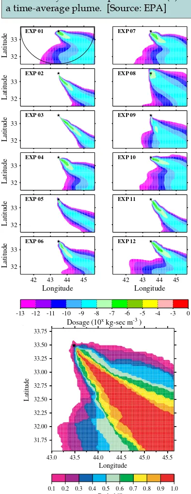
For emergency responders who must make life-saving decisions based on a dispersion model’s predictions, it is critical that the model provide a realistic understanding of the uncertainties in its predictions. Figure 1 illustrates how the actual dispersion of a plume can differ from its representation as a “time-average” concentration. The report recommends the use of “ensemble modeling,” depicted in Figure 2, or other approaches that provide not only average downwind concentrations, but also well-bounded estimates of the variability for any given event.
Another critical element is the ability to model the effects of complex urban topography, where local wind patterns can carry contaminants in unexpected directions. Models must also provide for the unique needs at each of the three stages of emergency planning: preparation, response, and recovery. Short execution times are most critical in the response phase, while slower but more accurate models can be used for the preparation and recovery phases.
In the report’s review of selected existing dispersion modeling systems, it was found that no one system had all the features deemed critical, although existing systems could potentially be enhanced to supply critical features. Suggestions for strengthening dispersion models include the following:
• Develop new techniques for providing probabilistic information to emergency responders that adequately convey conidence estimates for dosages within the predicted hazard zone.
• Learn how to more effectively assimilate meteorological data and real time data from C/B/N sensors, especially as the quality and availability of these data increase.
• Conduct urban ield programs and wind-tunnel urban simulations in order to test, evaluate and develop modeling systems.
• Improve the capabilities of meteorological models to account for the effects of urban surfaces on atmospheric energy, moisture, and momentum; develop and maintain urban building/topography three-dimensional databases.
43.0 43.5 44.0 44.5 45.0 45.5
Longitude
0.1 0.2 0.3 0.4 0.5 0.6 0.7 0.8 0.9 1.0
Probability
figure 2. (far right) Example of surface dosage predic-tions from a coupled meteorological and dispersion model, showing 12 ensemble runs for a hypothetical release of a gas from the location marked with the star symbol. The input data and model physics varied among the ensemble members. (near right) Aggregate of the ensemble members, showing the probability of the dosage exceeding a pre-determined threshold level. [Source: Thomas Warner, NCAR]
enhancing observational resources
Real-world observations, which are the essential input to the models, can range from direct visual sightings of the plume to sophisticated sensor measurements. The most basic observations needed for a dispersion forecast are: 1) identiication of the plume, 2) characterization of low-level winds, 3) characterization of the turbulent layers through which the plume moves, and 4) identiication of areas of dry and wet deposition.
Once a C/B/N release occurs, nearby wind sensors and other ixed observation systems, as well as visible smoke plumes, will be used to help locate the site and the spread of the release. Mobile sensors, such as scanning Doppler lidars or radars, and unmanned airborne vehicles (UAVs) could provide valuable information in the irst minutes or hours after a hazardous release. The more detailed the observations, the better the model output. For example, a higher density of wind measurements surrounding a plume can reduce uncertainty in model predictions.
The report identiies gaps in our nation’s current observational systems and provides a detailed list of suggested improvements for meeting various observational needs. Perhaps the single most effective way to improve observational capabilities for the purpose of dispersion modeling is to make better use of the meteorologcial observational networks already in place. Enhancements to these systems could be prioritized for areas deemed most vulnerable to terrorist-related incidents. Speciic suggestions include the following:
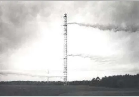
figure 3. The photo illustrates how wind direction can vary dramatically at different heights, underscoring the need to enhance observational networks with instruments that can provide vertical proiles of wind and temperature.
[Source: Brookhaven National Laboratory]
• Conduct a comprehensive survey of the capabilities and limitations of existing observational networks, with follow-up to improve these networks and access to them, especially in vulnerable areas.
•
Supplement Doppler radar networks with lightweight, short-range, technologies to monitor winds and precipitation and to possibly help identify the plume.•
Include wind and temperature profilers as an integral part of ixed-observational networks (see Figure 3).•
Develop the use of mobile scanning equipment and UAVs for obtaining measurements in areas where other platforms cannot easily reach.•
Conduct ield exercises focused on C/B/N releasesto better understand atmospheric dispersion in different weather as well as in daytime and nighttime conditions; utilize datasets from ield programs with a related focus such as as improving weather forecasts and understanding boundary layer turbulence.
The observational and modeling tools used for dispersion forecasting can have many other important uses such as air quality monitoring, severe-storm forecasting, and highway network safety. Every effort should be made to utilize existing instrumentation for multiple applications, to help justify costs and ensure that the systems will be continuously used, maintained, evaluated, and quality-controlled.
meeting the needs of emergency responders
This report brief was prepared by the national research council based on the committee’s report. for more information, contact the National Research Council’s Board on Atmospheric Sciences and Climate at 202-334-3512. Tracking and Predicting the Atmospheric Dispersion of Hazardous Material Releases is available from the National Academies Press, 500 Fifth Street, NW, Washington, DC 20001; 800-624-6242 or 202-334-3313 (in the Washington area); www.nap.edu.
committee on Atmospheric Dispersion of Hazardous Material Releases: Robert J. Serain (chair), National Center for Atmospheric Research, Boulder, Colorado, eric J. Barron, Pennsylvania State University, University Park, howard B. Bluestein, University of Oklahoma, Norman, steven f. clifford, University of Colorado, CIRES, Boulder, lewis m. duncan, Dartmouth College, Hanover, New Hampshire, margaret a. lemone, National Center for Atmospheric Research, Boulder, Colorado, david e. neff, Colorado State University, Fort Collins, William e. odom, Hudson Institute, Washington, D.C., gene J. Pfeffer, Ridgeield Consulting, Colorado Springs, Colorado, karl k. Turekian, Yale University, New Haven, Connecticut, Thomas J. Warner, University of Colorado, Boulder, John c. Wyngaard, Pennsylvania State University, University Park.
copyright 2003 The national academies
Permission granted to reproduce this report brief in its entirety with no additions or alterations. To bring together emergency response teams and members of the atmospheric modeling and observational communities, the report recommends convening regular “tabletop” event simulation exercises (i.e., roundtable discussion and planning) . Through these meetings, emergency responders can learn about the strengths and weaknesses of existing observational and dispersion modeling tools, and the situations under which various types of tools perform best. Conversely, dispersion modelers and meteorologists can learn how nowcasts/forecasts are used in emergency response situations.
The need for coordination
Each of the federal agencies currently involved in dispersion modeling activities has developed its own “customer base” and areas of strength and specialization. While this distributed organizational structure may continue to be an effective option, a strong center of coordination is needed to fulill some of the higher-level goals of this report. A carefully crafted management strategy with clear lines of responsibility and authority is essential to facilitate further progress in the development and operation of dispersion modeling systems and to ensure that emergency responders have unambiguous guidance as to where to turn for help.
To that end, the report recommends that a nationally coordinated effort be established to foster support and systematic evaluation of existing models, and research and development of new modeling approaches, undertaken in collaboration with the broader meteorological community. The Ofice of the Federal Coordinator for Meteorology, which recently organized a review of U.S. dispersion modeling capabilities, could provide valuable input as to which agency is best suited to oversee this coordinated effort. This coordinated effort should also exploit the wealth of knowledge about meteorological and dispersion models that reside in universities, National Weather Service (NWS) Weather Forecast Ofices, and private sector facilities throughout the nation.
To gain a better understanding of model capabilities and limitations, the report recommends establishing a fully operational dispersion tracking and forecasting system in at least one large urban area with the ability to provide immediate model forecasts on a full-time basis. If possible, a few such systems should be established and evaluated for different types of urban areas (e.g., coastal versus inland cities, or low altitude versus high altitude cities).