More accurate population data—based on census and other data that provide information such as peoples’ ages, gender, ethnicity, and where they live—are needed to better plan for and respond to humanitarian crises. Such data illuminate exactly how much and what type of aid is needed and where. All nations should be enabled to conduct a nationwide census every ten years, and this information should be geographically referenced. Population data alone are not suficient but must be accompanied by interagency coordination and training in the collection, use, and distribution of the data.
E
ach year, millions of people around the world are displaced by natural or human-induced disasters and social conlicts resulting in humanitarian crises. The South Asian earthquake and tsunami in 2004, Hurricane Katrina in 2005, and the ongoing conlict in Darfur are recent, highly publicized examples. The number, demographic characteristics, and locations of the populations at risk during events like these are often inaccurate or unknown, complicating or delaying response and relief efforts. Population data and the tools and people trained to analyze and use them are essential for effective humanitarian response to disasters, as well as for development and reconstruction programs.Tools and Methods for Estimating
Populations at Risk from Natural Disasters
and Complex Humanitarian Crises
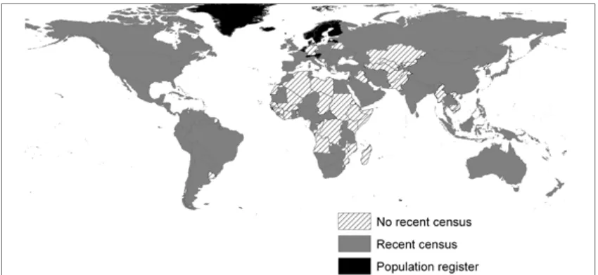
Figure 1. Censuses by country as of the year 2005 based on data back to the year 2000. Most countries
have taken a census in 2000 or more recently. Many of the places without recent census data also have populations highly vulnerable to the impacts of natural and human-induced disasters. These ‘at-risk’ populations require good base census data and the tools, training, and an institutional framework in which the data can be used before and when disasters strike. Source: Courtesy of and adapted and up
Resource-poor nations are often the most vulnerable to the effects of a natural disasters or hu -man-induced events, and are likely to require exter -nal assistance for the resulting humanitarian crisis. Those nations are also likely to have the greatest dificulty obtaining, maintaining, and distribut -ing their population data for response efforts (see Figure 1). However, as demonstrated by Hurricane Katrina, even countries with adequate inancial resources and good population data do not always effectively respond to a crisis. Such data need to be collected, analyzed and maintained in a coordinated way for seamless distribution to responders and de-velopment organizations at local, regional, national, and international levels.
This report provides a framework for making better estimates of populations at risk and
neces-sary actions at the institutional level to improve the ability to use georeferenced population data to conduct timely, effective disaster relief, response, and recovery work.
Why Population Data Should Be Linked To
Location
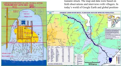
It is not uncommon for humanitarian or emer-gency response teams to be deployed without even rough estimates of the number and location, let alone ages and gender, of the people in the vicin -ity of the disaster. Even low tech maps—drawn with pen and paper—that show location of homes, streets, and other information can be life-saving tools in an emergency. Figure 2 is a hand-drawn map of a coastal village in India reconstructed by a irst responder to the area after the Indian Ocean tsunami struck. The map and data were based on ield observations and interviews with villagers. In today’s world of Google Earth and global position
-Figure 2 (above left). Despite an enormous contribution of international relief aid to areas affected by the Indian
Ocean earthquake and tsunami, and the advanced technology available to some responders, immediate relief efforts often relied on hand-drawn maps such as the one of the Kameswaram village in India. The map, which was derived from information collected from villagers, contains population data relevant to assistance providers, demonstrating that adequate aid does not necessarily require advanced technology—rather advanced technology requires appropriate and timely input of data. Source: Courtesy of Abbiah Subramanian, Madras Christian College, India.
Figure 3 (above right). Although hand-drawn maps like that in Figure 2 are practical and accurate, digital maps that
incorporate census data are most desirable because the digitally referenced data can be updated quickly and potentially distributed widely to responders and emergency managers, if the appropriate hardware and power or electrical require
ing systems (GPS), population data can be woven together with geographic information systems (GIS) to generate technically advanced, accurate maps as shown in Figure 3. These types of digital maps can be updated in real time and can potentially be more easily transmitted to responders. Unfortunately, this digital marriage of data and maps is not yet rou -tinely carried out.
Regular Censuses and Training Are
Priorities
National census data are the foundation for measuring populations at risk from disasters. All countries’ national statistical ofices should be provided with the resources and training to conduct a nationwide census every ten years. Efforts should be made to improve the ability of census-poor countries to administer their own censuses through training and technical assistance programs initiated
and supported internationally. This type of invest -ment should reduce the possibility of misapplied humanitarian and development aid. The work of na -tional statistical ofices, which collect and analyze population data, should also be better integrated with relief organizations who are using the data “on the ground.”
Censuses should have minimum standards for the release, availability, and archiving of data. The report recommends:
• Developing a template of minimum accept -able population and other geospatial data sets that are required by disaster responders. Data sets should be updated at least mid-decade if not more frequently. This could be done with surveys and ancillary data.
• Setting standards for the types and amount of information that countries should share with emergency responders and relief agencies.
Methods for Estimating and Characterizing Populations
The quality and level of population data will have a direct effect on the quality of the response and the number of lives saved. Decision makers often lack the population data for the affected area, including the total number of people and their characteristics, density, and vital statistics. The following are several ways to collect population data.
• Census: provides information about the number of people in an area and population characteris
-tics such as age, gender, or race/ethnicity, economic status, and housing statis-tics; measures people based on their place of residence only; in most industrialized countries, censuses are conducted once every 10 years with intercensal updates provided by a variety of surveys.
• Population surveys: local, national and international actors involved in development and hu
-manitarian activities carry out surveys on a regular basis to scope information on health, nutrition, access to water, housing, poverty eradication, etc.; surveys produce baseline population data and indicators relevant for risk and vulnerability assessment and identify speciic characteristics of subnational groups; these can be used to update census data.
• Population projections: mathematical projections use available data and formulas that incorporate
predictions of mortality, birth rates, health and education status to estimate the growth of various parts of a population over time; often used for countries where no recent, reliable population data exist.
• National and global population databases: global spatial databases of population applied to
identify populations at risk; use models to allocate national-level population data to a global grid consisting of quadrilateral areas of speciied size; capture total population size in the grid but not demographic information; supplementary source for population size and distribution where little reliable information exists, or is not available.
• Proxy measures: remotely sensed imagery serves as a supplementary source for population size
Committee on the Effective Use of Data, Methodologies and Technologies to Estimate Sub-National Populations at Risk: Susan L. Cutter (Chair), University of South Carolina; Margaret Arnold, World Bank and ProVention Consortium; Deborah Balk, City University of New York; Bela Hovy, United Nations Population Division; Mei-Po Kwan, Ohio State University; Jonathan D. Mayer, University of Washington; David R. Rain, George Washington University; Havidan Rodriguez, University of Dela -ware, Newark; Barbara Boyle Torrey, Population Reference Bureau; Billie L. Turner II, Clark Univer -sity; John R. Weeks, San Diego State University; Tukufu Zuberi, University of Pennsylvania; Elizabeth Eide (Study Director), National Research Council
This report was prepared by the National Research Council based on the committee’s report. For more information, contact the Board on Earth Sciences and Resources at 202-334-2744 or visit http://dels.nas.edu/besr. The report was sponsored the U.S. Department of State, National Aeronautics and Space Administration, U.S. Agency for International Development, U.S. Department of Commerce/Census Bureau, and U.S.Department of Health and Human Services/Centers for Disease Control and Prevention.
Copies of Tools and Methods for Estimating Populations at Risk from Natural Disasters and Complex Humanitarian Crises are available from the National Academies Press, 500 Fifth Street, NW, Washington,
D.C. 20001; (800) 624-6242; www.nap.edu.
Permission granted to reproduce this document with no additions, deletions, or alterations.
© 2007 The National Academy of Sciences • Establishing a central, worldwide archive
for local and regional population data using templates available through exist -ing archives to help authorities deal more effectively with humanitarian crises. The archive would serve as a repository for shared local data, and would disseminate data during a disaster to the appropriate response communities.
Research to Identify At-risk Populations
There are various approaches for est-imating population size and understanding the vulnerability of groups. To better identify at-risk populations, the following research is needed to determine which approaches would be most helpful:
• Test the accuracy of estimates of popula -tion size and distribu-tion based on re -motely sensed imagery, particularly in rural and urban areas of countries with spatially, demographically and temporally inadequate census data.
• Improve analyses of vulnerability to natu -ral disasters and conlict in order to deine hazard zones or exposures where routine, periodic data collection could occur.
Developing georeferenced vulnerability analyses could help provide accountability to decision makers in preparedness and prevention and establish priorities for risk reduction invest -ments by all stakeholders.