E-ISSN: 2347-5129 P-ISSN: 2394-0506
(ICV-Poland) Impact Value: 5.62 (GIF) Impact Factor: 0.549 IJFAS 2017; 5(3): 21-26 © 2017 IJFAS
www.fisheriesjournal.com Received: 05-03-2017 Accepted: 06-04-2017
Brehan Mohammed Yesuf
Amhara Regional Agricultural Research Institute, Bahir Dar Fish and Other Aquatic Life Research Center, Bahir Dar, Ethiopia
Correspondence
Brehan Mohammed Yesuf
Amhara Regional Agricultural Research Institute, Bahir Dar Fish and Other Aquatic Life Research Center, Bahir Dar, Ethiopia
Fisheries, water quality status and management
challenges of Lake Gudera Wetland, West Gojjam
Zone, Sekela district Ethiopia
Brehan Mohammed Yesuf
Abstract
The present study was conducted from 2012 to 2014 in Lake Gudera which is located in Amhara Regional state West Gojjam Administrative zone, Sekela Woreda. Insitu measurement for pH, oxygen, temperature, total dissolved solids, conductivity and salinity measured at 4 oclock in the morning using YSI 556 multi-meter probe. Secchi transparency measured using secchi disc, depth using depth meter and the amount of nitrate, phosphate, ammonia, total hardness and alkalinity measured using Wag tech Palin test photometer 5000 immediately after sampling. Questionnaire developed and interviewed from key informants and inhabitants of the area was collected. The chemical composition indicated that phosphate, ammonia, nitrate, and turbidity was 0.18 mg L-1, 0.18 mg L-1, 1.054 mg L-1 and 59 NTU, respectively which was high exceeding the standard level set by different countries for aquatic life in freshwater bodies. The mean pH (8.38) in the littoral site which was found very approximate to the permissible pH
(6.5 to 8.5) prescribed by the USEPA 2005 [13] Standard. The mean depth from the two study sites was
1.65 m which was 1meter by far less than the previous reports. This might have been a result of agricultural activities experienced adjacent to the Lake. Copepoda (59%) was dominant taxon which was followed by Cladocera (41%). The high level of most of the studied parameters in this study showed the water quality in this situation is deteriorating and this might have detrimental effects on the health of fish and other aquatic biodiversity in the lake.
Keywords: Biodiversity, physico-chemical parameters, wetland management, aquatic life
Introduction
Lake Gudera wetland is located in Sekela Woreda of West Gojjam zone Ethiopia. It is a highland freshwater lake with an estimated area of 140 ha with shallow depth of about 2.5 m
and has an elevation of 2352 m.a.s.l Endalew et al 2010 [9].This lake is highly degraded by
agricultural activity, but still serves the local community for irrigation and livestock watering. For lake aquatic ecosystems, human activities in the watershed can lead to loss of dominant species and functional groups, high nutrient turnover, low resistance, high porosity of nutrients
and sediments, and the loss of productivity Endalew et al 2012 [11]. The watershed ecosystem
services of Lake Gudera - water, land, livestock, forests, and cultural assets - offer considerable social and economic benefits to the livelihoods of its local people scattered in the bordering Kebeles particularly livestock grazing areas around the lake and within its basin. The lake and its wetlands are high in biodiversity - providing a habitat for many birds, but the lake is also used as a sink for the disposal of agricultural wastes. The growing population pressure, predominantly the landless young generation, demanding agricultural land and livestock is mainly dependent on the Gudera wetlands for grazing. These are the dominant factors responsible for serious natural resources degradation. The resource use of the wetland of Lake Gudera is open access, in the absence of regulatory framework for allocating, managing and protecting this contributes to the emerging conflicts over resource use and threats to the lake ecosystem. The wellbeing of wetlands is of vital importance for people and the environment to reduce poverty. However, these resources are exposed to anthropogenic impacts due to various problems. Some of which are lack of a national wetland policy/strategy and a lead institution that coordinates the efforts of wetland affiliated stakeholders. Knowing these impacts of anthropogenic activities this research tried to fill the knowledge gap by assessing the status and the management problems of the Lake Gudera.
The objectives of the research were: 1 to collect current information on fisheries water quality and its management problems 2. To create intervention mechanisms in development, management, research and extension services in the watershed of Gudera to sustain its ecosystem services.
Materials and Methods Study Area
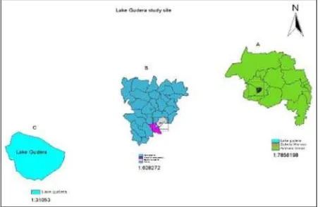
Lake Gudera is located in Amhara Regionional state West Gojjam Administrative zone, Sekela district bordered by Asewa and Zegeza Tengefa Kebeles. It is a highland freshwater lake with estimated area of 140 hectares (Fig. 1)
with shallow depth of about 2.5 m [9]. Lake Gudera is an
important water source for the local community especially during dry season for irrigation and livestock watering. The watershed vegetation coverage differs in the lower and in the upper area, the upper being devoid of the natural cover due to heavy agricultural activity and the lower area covered with natural shrubs due to less-agricultural activity (personal observation).The shoreline macrophyte has been shrinking from time to time due to high pressure for agriculture activities within the wetland of the lake. It is highly degraded by anthropogenic activities, but still supports a wide range of goods and services significant for the local community and the environment.
Fig 1: Map of Amhara National Regional State, West Gojjam Zone, in the rectangle (A) Map of Sekela Woreda and Lake Gudera bordering Kebeles – in the rectangle (C) Map of Lake Gudera (Map
done by MIhret Endalew).
Data collection and analysis
In situ measurement of basic water quality parameters: pH, oxygen, temperature, total dissolved solids, conductivity and salinity using YSI 556 multi-meter probe, secchi transparency using secchi disc, depth using depth meter, the amount of nitrate, phosphate, ammonia, total hardness and alkalinity measured using Palin test tablets and Palin test photometer 5000 has been collected twice representing the littoral and open water areas. Zooplankton (80 micrometer) and phytoplankton (55micrometer mesh net) samples collected using water sampler and identification of the plankton samples were done in the laboratory. Sampling has been done 4 times with the two years interval. Fish sample were collected twice by using 6cm,8cm, 10cm and 12cm mesh size gillnet by setting overnight and monofilament net were set for 30 minutes in the day time. 10 litre water was taken for plankton sample from the lake and it was sieved by 50micro meter mesh net for phytoplankton species and 80micro meter mesh size net for zooplankton species from all the sites. Questionnaire survey in Gudera wetland watershed Kebeles
was deployed and the data includes land use and land cover, livestock, topography and soil type in these Kebeles. Focus group discussion with local community to obtain indigenous knowledge was considered.Other supportive secondary data were collected from Sekela Woreda Agriculture Office. Field observation on major human impacted activities and major ecological changes for the last two and three decades was considered and Sekela Woreda Office of Agriculture experts were contacted and consulted for secondary information. GIS was used for mapping to ease communication among the
stakeholders. Libraries of the Amhara Regional Agricultural
Research Institute and Bahir Dar Fish and Other Aquatic Life Research Center were searched for relevant literature. The data were collected from 2012-2014 but due to many factors like logistics and accessibility of the lake data has been collected once in a year. The collected data were analyzed using SPSS version 20 and with descriptive statistics in Microsoft Excel
Results and Discussion
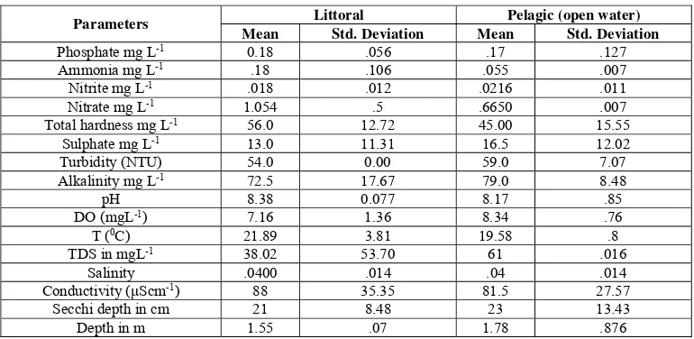
The mean phosphate and nitrate level of the water sample in the littoral site of the sample was high exceeding the standard
level set for freshwater bodies in USEPA 2005 [13] (0.02
mg/L) is recommended maximum phosphate level in Lakes which is conducive for aquatic life including fish according to
USEPA 2005 [13]. The mean phosphate value of the littoral
zone is 0.18 almost 0.2 mg/L(Table 1).The fishes inside this lake might get slow to grow due to the deterioration of water quality in the lake. The high rates of agricultural runoff may cause large quantities of nitrates and phosphates to enter the water system. These nutrients might bring algal bloom which possibly affects water quality. The blooms might deplete oxygen levels in aquatic ecosystems and thus have a detrimental effect on the organisms within the system. Phosphorus enters to a Lake from a wide range of sources along the shoreline and sub-watersheds that drain into the Lake. These sources include point sources, such as discharge from municipal and industrial wastewater facilities and non-point sources, such as basin-wide, diffuse inputs from fertilizers, animal waste and atmospheric deposition. However, the main sources of new phosphorus were non-point inputs from watersheds where runoff from agricultural and urban lands contribute large amounts of phosphorus. The
US-EPA 2005 [13] regards agriculture as the leading source of
impairment of rivers and lakes with nutrients ranking second only to siltation as the pollutant most affecting rivers and lakes. Results of this study showed high concentration of total dissolved solid (61mg/l), electric conductivity (81.5), total hardness (45mg/l), sulphate (16.5mg/l) which might indicate signs of water quality deterioration.
The mean turbidity value in the littoral area was 54 NTU while mean turbidity value in the open water part was 59 NTU. This is by far higher from the result obtained by
Endalew et al. 2010 [9] which was 26 NTU in the littoral area.
In this study, the mean value of turbidity in the lake is almost
as double as registered in 2010 in Endalew et al 2010 [9] work
and this showed the wetland has lost its vegetation cover which might trap sediment and nutrient runoff. The lake is turbid in the present study this might have a problem for any aquatic life in the water.
of pH from 6 to 8.5 for fisheries and aquatic life Chapman,
1996 [7]. Therefore, in the current state it might be difficult for
fish to live in the lake.
The mean total hardness values 56 mg/l and 45 mg/l in the littoral and open water area respectively are within the desirable concentrations of total hardness level for fish with a
range of 20-300 mg/l (Boyd 1975 [6]). The mean alkalinity
results 72.5 mg/l and 79 mg/l in the littoral and open water area puts the lake in medium production of fish and aquatic lives (Table 1). Because in highly productive waters, the alkalinity ought to be over 100 mg/l. However, the range of alkalinity as 0.0 – 20.0 mg/l for low production, 20 – 40 mg/l
for medium production Pandey and Shukla, 2005 [12])
According to Boyd 1979 [5] the secchi depth measurement
which is 20 – 30 cm will make plankton overabundant and algal bloom may occur and it may cause dissolved oxygen depletion if it is less than 20 cm; 30-45 ideal for aquatic organisms. The result of the littoral area of the secchi disk measurement is 21 cm this shows the lake is becoming turbid no light can pass through and this will hinder photosynthesis process. Algal bloom may occur soon if the management continues in the current way and this may have detrimental effect on the fish fauna and other aquatic life.
According to Endalew et al. 2010 [9] this lake had been 2.5 m
in depth before some years ago but during this study the mean
depth of the littoral(1.55 m )and open water(1.78m) site which means 1 m less by far than the previous study in this lake. This is an alarming case to see how much silt load is entering to the lake.
Previous studies done in different parts of Ethiopia confirmed that, the major sources for nutrient load causing cultural eutrophication in Ethiopian lakes emerge from natural runoff, inorganic fertilizer and manure runoff from the farming system, soil erosion from poor land use and poor watershed
management Endalew et al 2012 [10]. There are cases of
natural lakes in Ethiopia which either disappeared or nearing
to disappear as a result of mismanagement Alemayehu T et al
2007 [2].
Lake Haramaya, Lake Kilole and Lake Gudera as well as man-made dams that are completely or nearly silted up as a result of over abstraction, poor land use and sedimentation can be mentioned in Ethiopia. Excessive exploitation and withdrawal water can lead to a total collapse of the resources as evidenced on Lake Haramaya in Eastern Ethiopia Abunie
2003 [1]. One can see from the above results that in Lake
Gudera there is a sign of decreasing and deteriorating of its water quality and as well as its depth and the fate of this lake is under the communities willingness to manage properly and the government’s effort to create awareness.
Table 1: Results of water quality parameters of the two sampling sites
Parameters Littoral Pelagic (open water) twice but only one small Garra species fish which mostly is not used for human consumption in the two different sites but there was no any fish caught except the small Garra species. But the inhabitants told us that there were some fish in the lake before 8 or 9 years back even though no documented information was found regarding the fish introduction. The probable cause for this is expected to be deterioration of the water quality. Most of the mean physico-chemical parameters were higher than the permissible limit or the standard level set by different countries. But if the current agricultural practices near to the shore area reduced and the water quality will be improved and fish may grow and reproduce well
Zooplankton composition and abundance in Lake Gudera In this study, a total of 530 zooplankton individuals (inds.) were collected, which comprises up of 5 genus belongs to 2
orders (taxa). Of these, the most abundant taxon was copepoda (330 ind. or 59%), which was followed by Cladocera (200 inds. or 41%). The density contributed by the two taxa and density in terms of individual per liter of lake water and relative abundance of zooplankton are summarized in Table 2.
Commonly, copepods dominate the zooplankton community
in most aquatic ecosystems Aminu, R 2000[3] Their
dominancy in most cases is due to their flexibility and adaptability to changing environmental conditions and ability to withstand varying environmental conditions Bames et al
1988 [4]. In Lake Gudera, cyclopoid copepod was the
Table 2: Density and percentage relative abundance of zooplankton taxa of Lake Gudera.
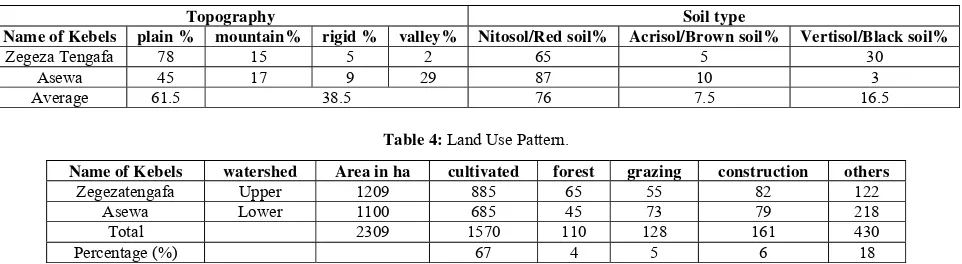
zooplankton taxa abundance ind. / lit % Relative Abundance Copepod northern highlands (Table 3). The soils of the Gudera wetland watershed consists 76% nitosol / red, 7.5% acrisol/ brown and
16.5% vertisol/ black. The undulating slopes increase rain
water runoff rates, which can increase erosion and sediment in
the wetland, and deposit sediments in the Lake. The Agro-ecological zone of the wetland watershed consists of the
traditional category 100% Dega(2300-3300 m.a.s.l). The land
use pattern consists of 67% farmland, 4% forest and bushes, 5% grazing and 6% construction and 18% others (Table 4).
Table 3: Topography and soil type.
Topography Soil type
Name of Kebels plain % mountain% rigid % valley% Nitosol/Red soil% Acrisol/Brown soil% Vertisol/Black soil%
Zegeza Tengafa 78 15 5 2 65 5 30
Asewa 45 17 9 29 87 10 3
Average 61.5 38.5 76 7.5 16.5
Table 4: Land Use Pattern.
Name of Kebels watershed Area in ha cultivated forest grazing construction others
Zegezatengafa Upper 1209 885 65 55 82 122
Asewa Lower 1100 685 45 73 79 218
Total 2309 1570 110 128 161 430
Percentage (%) 67 4 5 6 18
The major crops grown in the wetland watershed are cereals (65%), pulses (5.4%), oilseeds (0.4%), spices (2.2%) and vegetables, root crops and fruits 27%). The livestock
population in Gudera watershed is about 21219 in number
(46% cattle, 2.8% equine, 23.9% sheep and goat, 2.3% apery and 25 % poultry). The human population of Gudera watershed is around 56714 (44% male and 56% female) (survey from the Sekela Woreda Environmental office). The focus group discussion emphasized that the encroachment of Lake Gudera wetland started in 1986/87 and became more aggravated in 2002/2003 and still progressing without any monitoring action. It also emphasized that littoral zone macrophyte of the wetland had been completely converted into agricultural land and settlement. The focus group discussion also expresses the Lake Gudera water level difference is notably high during the rainy season and low during the dry season. The catchment has steep slopes that should not be cultivated but are still used for cultivation. Field observations indicate the real picture of Lake Gudera and riparian zone. The Zegeze River diversion that changed the natural river course prevents recharging of the lake. Critical problems observed on the wetland and the surrounding watershed include vegetation removal, land degradation, wetland hardening, over grazing, water use management and water use conflicts, and lack of institutional accountability. Lake Gudera watershed area covers 6634 ha (Fig. 3). The Lake area covers 140 ha or (2%) of the watershed of Gudera
Endalew et al 2010 [9]. The basin wide problem of Gudera
includes soil erosion particularly on the northern and western part of the basin where anthropogenic activities and natural resource degradation are intensely practiced when compared with the southern part which is covered with shrubs and
bushes. Poor land use and clearing of forests/macrophytes in and around the wetlands has induced sedimentation that can reduce the water storage capacity of the wetland. The observable problem in the littoral zone of Lake Gudera is the removal of macrophyte, recessive agriculture during the dry season and loss of wetlands that reduce the bio-filtering role and habitat degradation for its biota. The focus group discussion also magnified the wetland loss of Lake Gudera in two to three decades. The other problem in the basin is the Zegeze River diversion that hindered the recharging process of Lake Gudera.
The wetland issues at national and regional level are diffused and overpowered in natural resource management policies
and strategies such as, in water resources development,
forestry development, agricultural and rural development,
Conclusions
The Gudera wetland is poorly protected due to lack of integrated watershed management practices which resulted in natural resources degradation. The wetland is encroached from time to time, for agricultural activities losing its natural filtration and buffering capacity aggravating the silt load from the poorly protected watershed. There is no systematic monitoring and control of point and non-point sources of pollution from farm lands, grazing lands, domestic and runoff in Gudera watershed. The sediment loads in Gudera influences the wetland ecosystem by increasing turbidity and reduce water transparency and productivity, contributing to aging and changes in the morphology of the wetland. A critical look at the physico-chemical parameters of the water samples from all the sites according to different countries and authors standard indicate that the water quality parameters result of the lake were higher than permissible limits for aquatic life. Various parameters have been observed to either approach or to have exceeded the permissible limits set for aquatic life. Hence the water can be said moderately eutrophic and less healthy or conducive for aquatic ecosystem. The high level of most of the parameters in this study may have detrimental effects on the health of fish and other aquatic biodiversity found in the lake. This has been proved by having no fish sample during our sampling period. It is clear that the water quality of Lake Gudera is continuously degrading. The source of water pollution in this Lake is basically agricultural wastes. Therefore, there is a need to protect this lake from being totally degraded like Lake Haramaya. Inadequate policy framework to manage the resources in the lake basin and inadequate scientific knowledge on socio-economic, ecohydrology and other biological resources are important issues to be considered for the management of Lake Gudera watershed.
The lake has no any boundary the lake itself is the boundary for the land owner near to the lake so farmers thought the lake is their own land. They always practice their agricultural activities when the volume of the lake reduced in the winter time. Almost in all summer and winter time the local community interchangeably uses the lake shore for agricultural activity. This makes the lake vulnerable to huge run off and high silt load.
The prevailing open access situation without delineation of the Lake boundary that prevents encroachment has endangered the lake. The lake will disappear if mitigation measures are not taken as fast as possible.
Recommendation
The basin wide problem of Lake Gudera includes soil erosion particularly on the northern, eastern and western? part of the basin where agricultural activity and deforestation is dominant when compared to the southern part covered with shrubs and bushes. The sustainable management of Lake Gudera basin for its ecological, social, biodiversity and economic values requires attention from its stakeholders. The integration of the human values and thoughts is highly significant to holistic management of watershed resources. Participatory management approach and use of indigenous knowledge and experience of the stakeholders in extension services, research and management is the priority measure for Lake Gudera resources management to sustain its ecosystem services for the present and the next generations.
The hydrology of Lake Gudera needs future review, to estimate average annual inflows into the lake from tributary
runoff and direct rainfall, and outflows downstream as flooding is high at upstream. There should be Lake Boundary delineation to protect from huge run-off. The community should be awaked while they are threatening their lake. because most of the inhabitants didn’t even know how much they are affecting the Lake.
Stakeholders should integrate to take remedies and make the local community willing to stop their recession agriculture.
Acknowledgements
We acknowledge the Sekela Woreda Agriculture office and its experts, livestock, natural resource and Asewa and Zegeze Tengafa Kebeles’ Development Agent for their help in field studies and the Sekela Woreda Administrator and the Sekela Woreda Culture, Tourism Information Office for recording of the focus group discussion event to understand the perception on the Lake Gudera ecosystem. We would also like to thank local communities and technical staff for their support and engagement.
References
1. Abunie L. The distribution and status of Ethiopian
wetlands: an overview. Wetlands of Ethiopia: Proceedings of a seminar on the resources and status of in Ethiopia’s wetlands. Gland, Switzerland: IUCN, 2013, 12-17.
2. Alemayehu T, Furi W, Legesse D. Impact of water
overexploitation on highland lakes of eastern Ethiopia. Environ Geol. 2007; 52:147-154.
3. Aminu R, Ahmed KS. Plankton periodicity and some
physico-chemical parameters of the intake Channel of Lake Chad. Journal of Aquatic Science. 2000; 19(2):104-11.
4. Barnes RSK, Calow P, Olive PJW. The Invertebrates: a
new synthesis. Blackwell Scientific Publications, London, 1988.
5. Boyd CE. Water quality in warm water fish ponds.
Craftmaster, Printers Inc. Auburn, Alabama, USA, 1979, 353.
6. Boyd Claude E, Walley WW. Total Alkalinity and
Hardness of Surface Waters in Alabama and Mississippi. Alabama Agricultural Experiment Station Bulletin no. 465. Bir-mingham, Ala. Auburn University Press, 1975.
7. Chapman D. Water quality assessments: A guide to the
use of biota, sediments and water in environmental
monitoring 2nd. Ed. UNESCO, World Health
Organization, United Nations Environment Programme, London, 1996.
8. Endalew M. Assessment of policy and development plan
issues related to Ethiopian fisheries [dissertation]. Hull: University of Hull. 1997.
9. Endalew M, Goshu G, Zelalem W. A preliminary survey
of the ecohydrological management challenges faced by Lake Gudera, West Gojjam, Ethiopia. Ecohydrol Hydrobiol. 2010; 10: 325-332.
10. Endalew M, Tollner EW. Assessment of major threats of
Lake Tana and strategies for integrated water use management. Proceedings of the 2nd national workshop of on: challenges & opportunities of water resources management in Tana. 2012.
11. Liu W, Qiu RL. Water eutrophication in China and the
combating strategies. Journal of Chemical Technology and Biotechnology. 2007; 82(9):781-786.
12. Pandey K, Skukla JP. Fish and Fisheries. Rastogi?
Publications, Meerut, India. 2005, 504.
13. USEPA. (United State Environmental Protection