IMPACT OF LAND USE CHANGES ON
KURANJI RIVER BASIN FUNCTIONS AS A SOURCE OF IRRIGATION IN
PADANG CITY, WEST SUMATRA, INDONESIA
Fetriyuna
1, Helmi
2, Dian Fiantis
3.1Department Technology of Food Industry, Faculty of Agriculture Industry Technology, University of Padjadjaran. West Java, 2Department of Socio Economic Agriculture, Facultyof Agriculture, Andalas University, 3 Department of Soil Science, Andalas University, Kampus Unand Limau Manis,
West Sumatra. Indonesia Email: [email protected]
Abstract
Kuranji River Basin is one of river basin in Padang, which plays important role to support people livelihood along the river especially as a source for irrigation and fish culture. Land use changes take place along Kuranji River Basin from 1994-2002. Land use changes has been ex-amined from the comparison of Land Utilization Map in 1994 which is derived from BPN and satellite image from Landsat ETM + in 2002, and also supported by various secondary data from biophysical and socio-economic as-pect. Land use along Kuranji River Basin has been changes as; annually forest area reduce as much as 209.3 Ha, while agro forest (mix garden) only increase 5.56 Ha, shrubs increase 140.29 Ha, agriculture field increase 80.51 Ha, and rice field reduce 299.73 Ha, settlement increase 207.13 Ha, and others (water bodies, road, etc) increase 76.19 Ha. The driving factors of land use changes in Ku-ranji River Basin can be classified as combination of popu-lation pressure and socio economic factors.
People in upstream already know the importance of forest for their livelihood. They consider forest as hydro-logical regulation (30.0%), biodiversity conservation (20.0%), environmental protection (20.0%), source of live-lihood (7.14%) and other (12.86%). Since farming activi-ties is mainly people upstream occupation and source of income, it is conventional wisdom which says that the exist-ing of forest will ensure water availability in river and irri-gation channel. This also include in several local wisdom which is believed by most of Minangkabau people. To se-cure their farming activities, people in upstream limit their self logging timber in state forest. That why, people in up-stream maintain the existence of forest, and only doing farming activity in their communal forest as an agro forest.
Water demand for both irrigation systems in Kuranji River Basin is 4.7 L/s, irrigation flow 6 liter/second will enough to watering all the functional area of rice field since there is a reduction in the total amount of rice field area in that location.
Keywords : river basin, land use changes, irrigation, Ku-ranji River
.
INTRODUCTION
Land use changes are often the result of a greatly in-crease population; continue economic growth and physical development especially in developing country like Indone-sia. In this situation there is rising pressure on space and resources which increases conflict and leads to the degrada-tion of precious land resources. Land use changes at the ‘source’ or upland areas of watersheds or river basin have effects on the users of the water downstream (Susswein, et
al, 2001).
Land use and management techniques on water-sheds/river basin can influence the quantity, reliability and quality of water downstream. Issues of water quality and quantity are at the forefront of environmental issues in In-donesia. One of the major concerns of the government, donors and public alike is how to manage land and water resources effectively.
A basin is the area of land that drains to a particular river or lake. Basin management is a geographically based approach to protecting and restoring water both quality and quantity that focuses on water resources. This concept is also known as watershed management, particularly when applied on a smaller scale (MPCA, 2002). The river basin is the logical unit of management for surface water, be-cause water resources within the river basin are inter con-nected and the allocation of water in one part of basin af-fects all downstream resources (UN, 2000 in MPCA, 2002).
The capacity of river basins to provide water, food, shelter and security has been substantially reduced. Water management has moved from a sectoral approach to an integrated approach, which has now been accepted as the key for solving simultaneouschallenges of securing water, food and livelihoods, as well as protecting the environment. Water management and development is a deeply political process, which deliberately affects social as well as eco-nomic structures.
Riparian forests should be managed rigorously to protect water quality. Effective watershed and forest management consistently yield significant environmental services, in-cluding high-quality freshwater supplies. Furthermore Kiersch (2000) argues that the impacts of land use change include changes in sediment load and concentrations of nutrients, salts, metals and agrochemicals, the influx of pathogens, and a change in the temperature regime.
Land use practices are assumed to have important impacts on both the availability and quality of water re-sources. These impacts can be both positive and negative. Different land use practices affect hydrologic regime and water quality and at which watershed scale the impacts are of importance. For example a change of land cover from lower to higher evapotranspiration1 (ET) will lead to a de-crease in annual stream flow, in tropical areas afforestation can lead to deceased dry-season flows due to increased evapotranspiration, deforestation and road construction may increase erosion (Kiersch, 2000).
Kuranji River Basin is one of river basin in Padang, which plays important role to support people livelihood along the river. It is prioritized to be managed in a sustain-able manner in order to guarantee services and functions. Kuranji River has importance as: (a) Ecological, where Kuranji River is a habitat for the aquatic resources, water catchments and regulates the hydrological balance. (b) Social, as a fresh water source especially for people sur-round and for urban and municipal community. (c) Eco-nomic, as a source for irrigation, fish culture and hydroe-lectric power.
Land use changes are often the result of a greatly in-crease population; continue economic growth and physical development especially in developing country like Indone-sia. In this situation there is rising pressure on space and resources which increases conflict and leads to the degrada-tion of precious land resources. Land use changes at the ‘source’ or upland areas of watersheds or river basin have effects on the users of the water downstream (Susswein, et
al, 2001).
Kuranji River Basin is chosen for this research based on two considerations: First, Kuranji River Basin is the largest river basin in Padang city which cover 20,980.50 Ha (Water Resources Management Agencies, 2006) which also has ecology, economic and social func-tions. Second, based on research conducted by Desmiwar-man, (2004), it is found that people activities along the river basin have impact on the physical and chemistry fac-tors Batang Kuranji River which effect on reducing the quality and the quantity of water in Kuranji River.
1
Evapotranspiration: the combined loss of water from a given area, and during a specified period of time, by evaporation from the soil surface and by transpiration from plants (Glossary of Soil Science Terms. 1997).
METHODOLOGY
This study employs the exploratory approach in un-derstanding the impact of land use changes on Kuranji Riv-er Basin functions. That process have been explored by compare satellite image and land use classification from National Land Resource Board (Badan Pertanahan
Na-sional or BPN) and support by social economic condition
people upstream and downstream river basin. Furthermore, river basin function is monitored through river basin condi-tion and its capacity to maintain the funccondi-tions for irrigacondi-tion water supply. This research hopefully significantly contri-butes to explain the linkage between land use changes and capability of river basin to maintenance their functions.
Two kinds of data were used for this study; second-ary data and primsecond-ary data. Secondsecond-ary data which mainly used in analysis are those available in PSDA (Dinas
Penge-lolaan Sumber Daya Air or Water Resources Management
Agencies), Indonesia Center of Statistical Agencies (BPS), National Land Resources Board (BPN), household survey data in upstream Kuranji River Basin which was conducted by Mr. Yonariza (unpublished data) and also several re-ports and government documents related to research topic. Primary data are collected through in depth interview with key informants from Leader of Farmer Water User Group (P3A) Limau Manis and Production Manager of Intake Pump Station (IPA) Gunung Pangilun.
Secondary data from PSDA cover climate and hy-drological condition of Kuranji River Basin, and also raw data of satellite image which has been classified based on land uses. Household survey data include educational at-tainment, economic condition of the household, perception about the importance of forest and forest activities. Data from BPS consist of administrative aspect for each sub dis-trict in Kuranji River Basin, demographic condition and welfare condition based on Village Development and Fami-ly Planning Agency Padang city.
The data obtained from in depth interview with the key informant are about existing condition of Farmer Water User Group (P3A) Limau Manis, including the continuity of supply from Kuranji River, and conflict that occurred in that area.
Data Analysis
The secondary data questionnaires (socio economic) are analyzed using statistical method (cross tab). Demo-graphic data and river basin condition are analyzed using descriptive method. Land cover changes are analyzed through comparative satellite image and land use map. Fi-nally those aspects will related to river basin functions.
RESULT AND DISCUSSION Profil Area of Study
Geographically, Kuranji River Basin is located in a latitudes 00 48’- 00 56’ S and longitudes 1000 21’ – 1000 33’ E. The Basin covers an area about 20,980.50 Ha, is distri-buted in four sub districts namely Pauh, Kuranji, Nanggalo and Padang Utara in Padang City. Total population in 2005 along Kuranji River Basin is 288955 people with total number of households are 66140. Upstream Kuranji River Basin is Pauh Sub District and several areas of Kuranji Sub District and downstream of Kuranji River Basin cover Nanggalo and Padang Utara Sub District. River basin can be classified by upstream as a rural area and downstream as an urban area which exists in 2.5-1600 m a.s.l. (above sea level).
Table 1 Elevation and Area of Kuranji River Basin Based on Sub District
Sub-district Elevation in m (a.s.l.: above sea
lev-el)
Source: BPS (Padang in Figures 2002).
1
Upstream
2
Downstream
Land Use Changes
Land use pattern in Kuranji River Basin varies from forest, agriculture area and settlement. Upstream river basin is covered mostly by forest whether protected forest or con-servation forest (state forest) and also communal forest mainly as agroforest which is cultivated with perennial crops for several uses. Several parts of upstream and down-stream area in this section classified as midledown-stream which is covered by rice field area and as an urban area down-stream which is mostly covered by settlement, industrial purpose, commercial and institution building.
Land use changes along Kuranji River Basin which derived from compare satellite image from Landsat ETM+ in 2002 with spatial resolution 15 m and Land Utilization
Map from National Land Resource Board (Badan
Pertana-han Nasional or BPN) in 1994 with scale 1:50000 (Table 2)
show changes mainly occur between rice field and settle-ment.
Land use changes are often as a result of greatly population growth, economic growth and physical devel-opment especially in developing country like Indonesia. In this situation there is an increase pressure on space and land resources which increase conflict and loss of capacity of resources to maintain their functions.
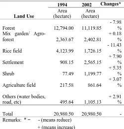
Table 2 Land Use Changes Based on Land Utilization Map from Land National Board (1994) and Satellite Image from Landsat ETM+ (2002)
Remarks: * = - (means reduce) + (means increase)
The possible scenario which was occurring in eight years are:
• Forest cover reduces and converted into agroforest or mix garden, especially in area which is claim as com-munal forest. Mixed garden refers to a smallholder fruit-based agroforestry system, privately managed by local people. This class is covered by a mixture of fruit trees such as durian (Durio sp.), avocado, lime, jack-fruit, as well as oter trees, like cloves, nutmeg, and beetle nuts. In some areas it is intensively managed, while others unmanaged-mixed gardens consist of a combination of fruit trees, woody shrubs, and non-fruit trees. Another type of mixed-garden around Kuranji River Basin is a coconut-based agroforestry system, with coconut as the dominant species.
• Forest also converted into rice field and agriculture field especially in area which not far away from local people settlement (result is derived from survey) particularly in foot hill and closely with irrigation channel.
Land Use
1994 2002 Changes* Area
• Total area which is covered by shrub increase 5.35 %, because of conversion of forest into mix garden or agro-forest need a reducing or removal standing agro-forest. Shrubs are characterized by an area covered by mostly woody-herbs combined with grass. These areas usually correspond to recently opened/-abandoned area, caused by shifting cultivation activity. Other forms of shrub in this class are abandoned land where farmer have left their land unmanaged for various reasons or lands left after fire/forest clearing.
• Rice field area reduces in term of number and converted into settlement, and road especially in upstream sub dis-trict. Logical reason is because of Andalas University construction which was started in early 1990 that en-courage people to build new house for rent for the stu-dent, and also building for commercial purposes. Beside that, for easy access to Andalas University, government try to construct two line roads in the area which origi-nally as rice field. Increasing number of population along Kuranji River Basin in addition give pressure on land demand for settlement.
• Increase of agriculture field because of the converted rice field become settlement in random location. This affects the rice field surrounding reducing or even loss of water irrigation accessibility. Therefore farmers re-place their rice field into agriculture field which is less water required.
River Basin Functions as a Source of Irrigation
Agriculture water demand can take various forms, which may differ considerably. Annual or seasonal crop-ping may allow variation in the water received from year to year and from season to season, and measures can be taken to neutralize fluctuations in supply. Alternatively, annual or seasonal cropping allows farmers to take an opportunistic approach to differences in water availability, but planting more or less (UN, 2000).
The existing irrigation system covers almost all the irrigable flat plain of river basins except for the urban area. On the contrary, the farm land adjacent to the urban area is replaced by housing, industrial and commercial area in recent year. The paddy field in Kota Padang decreases year by year. According to Master Plan Kotamadya Padang in 1983, only some agricultural land will remain mostly in the existing Gunung Nago (right) and Lubuk Minturun irri-gation systems by the year 2003.
In consideration of the circumstances mentioned above, it could be concluded that there is little demand for further irrigation water development in Padang City. On the contrary, the existing irrigation water which shares the ma-jor part of present water use in the basin would be used for the other municipal and industrial purpose in future keeping pace with replacement of agricultural land to municipal and industrial lands (JICA, 1983).
There are two irrigation areas in Kuranji River Basin, namely Gunung Nago and Limau Manis. Status of irrigation system in Gunung nago is technical. It covers 1888 hectare rice field with water demand 4.7 L/s, while in Limau Manis status of irrigation area is still semi technical which cover 632 hectare ricefield and water demand only 1.2 L/s (Table 3). Farmers are grouped into water user group (P3A) for each tersier channel of irrigation system. Each P3A has the rule for water allocation based on planta-tion period.
Table 3 Irrigation Area and Farmer Water User Group (P3A) for Irrigation Area in Kuranji River Basin Irrigation
Area
Status Functional Area (Ha)
Water Demand
(L/s)
Number of P3A*
Gunung Nago
Technical 1888 4.790 39 P3A
Limau Manis
Semi Technical
632 1.200 6 P3A
Source: Water Resource Profile, 2000
*Pusat Studi Irigasi, 2004
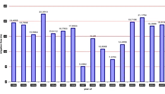
When we refers to water demand for both irrigation system in Kuranji River Basin, irrigation flow 6 lit-ter/second will enough to watering all the functional area of rice field. In reality, the average of Kuranji irrigation flows is 15.9 litter/second (exceed the irrigation water demand for rice field area). Unfortunately water from irrigation system in Kuranji River Basin is not only used for watering rice field area, but also for fish pond which is more water de-manded (see Figure. 1)
Figure .1. Kuranji Irrigation Flows
Source: Irrigation Area of Gunung Nago
There are assumptions which are believed by a number of scholars which try to link water availability and land use changes. They argue that reduce forest cover will effects water availability in river and also will influence the functions which are derived from it. In this case, forest cover decrease 7.98% in eight year from 1994 until 2002
Kuranji Irrigation flow
19,4855 18,7698
15,5964 22,3513
15,9112 16,7503
17,6933
5,0562 14,28
10,8068
7,3783 12,2859
19,7186 21,1754
18,398618,8193
0 5 10 15 20 25
1990 1992 1992 1993 1994 1995 1996 1997 1998 1999 2000 2001 2002 2003 2004 2005 year of
ir
ri
ga
ti
on f
low
(
l/s
and stream flow fluctuates from 3.02 m3/s to 8.46 m3/s with an average 5.06 m3/s. From that fact, it can be sure that reduce the area of forest cover not significantly affect the water availability in Kuranji River Basin. Because forest was converted into mix garden/agroforest, which combine tree crops with perennial or even annual crops. According to Van Noordwijk, (2002), agroforest is believed has the same capacity and capability with the primary forest in retaining water and storage water resource.
Based on information from key informant (Mr. Rus-li, the leader of Farmer Water User Group (P3A) Limau Manis), the amount of water availability for rice field irri-gation is more than enough almost for a whole year of plan-tation period,. However, there is a conflict in water alloca-tion between paddy and fish farmers. The conflict has been mitigated with the consensus of balance cycle of water al-location during plantation period.
Water availability has a linkage with the production of rice field. In Table 5.13 shows the planted, area har-vested and production for each sub district in Kuranji River Basin from 1994 until 2003. The production of paddy in that area tends to increase through time, because of abun-dant of water availability for irrigation, beside the modern mechanism and a guaranteed seed.
CONCLUSION
Land use along Kuranji River Basin has been changes since 1994 to 2002. Reducing forest area and rice-field but the other hand increasing of mix gar-den/agroforest, agricultural field, settlement, shrub and others. The driving factors of land use changes in Kuranji River Basin can be classified as combination of population pressure and socio economic factors, as follows:
• Population pressure in this area is high; with the num-ber of population increase 37.68 %, with annual growth rate 2.41 %. The growing number of popula-tion has impact on increasing demand of land re-sources for settlement and public infrastructure.. • People in the upstream claim that they have
commun-al forest which can be used for severcommun-al purposes espe-cially for farming activities. They convert forest into mix garden (agroforest) which promises more income security rather than monoculture tree planting in area which claim as communal forest
• Land use changes especially reducing the area of for-est cover not significantly affect the water availability in Kuranji River Basin. It illustrated by the stream flow of Kuranji River only fluctuates from 3.02 m3/s
to 8.46 m3/s with an average 5.06 m3/s. It is because of forest was converted into mix garden/agroforest, which combines tree crops with perennial or even an-nual crops. Agroforest is believed has the same capac-ity and capabilcapac-ity with the primary forest in retaining water and storage water resource.
• Water demand for both irrigation systems in Kuranji River Basin is 4.7 L/s, irrigation flow 6 liter/second will enough to watering all the functional area of rice field. In reality, the average of Kuranji irrigation flow is 15.9 liter/second (exceed the irrigation water de-mand for rice field area).
REFERENCES
CIFOR and FAO, 2005. Forests and Floods Drowning in Fiction
or Thriving on Facts? RAP Publication 2005/03 Forest
Perspectives 2
Desmiwarman. 2005. Faktor Lingkungan Batang Kuranji yang
mempengaruhi Kualitas Sumber Air Baku PDAM.
Mas-ter Thesis, Andalas University, West SumaMas-tera – Indo-nesia
JICA. 1983. Study Report on Padang Area Flood Control Project. Main Report. Republic of Indonesia, Ministry of Public Works Directorate General of Water Resources Development.
Kiersch, B. 2000. Land Use Impacts on Water Resources: a
Lit-erature Review. Discussion Paper No.1. Land-water
linkages in rural watersheds. Electronic Workshop. Food and Agriculture Organization of the United Na-tions, Rome.
Ministry of Public Works, Directorate General of Water Re-sources Development, 1983. Study Report on Padang
Area Flood Control Project. Prepared by Japan
Interna-tional Cooperation Agency. Tokyo. Japan
Minnesota Pollution Control Agency (MPCA), 2002. Basin
Plan-ning and Management an Approach to Managing Water Resources.
Pusat Studi Irigasi, 2004. Executive Summary, Study on Water
Resource Management The Potential Analysis of the Reservoir Development in Padang City. The Center for Irrigation, Water Resources, Land and Development Studies Andalas University
Susswein, P.M., M.van Noordwijk and B. Verbist. 2001. Forest
Watershed Functions and Tropical Land Use Change.
ASB Lecture Note 7. ICRAF SA. Bogor. Indonesia. United Nation. 2000. Principle and Practices of Water Allocation
Among Water-Use Sectors. Water Resources Series