102
SPARSE CODING-BASED METHOD COMPARISON FOR LAND-USE CLASSIFICATION
Dewa Made Sri Arsa1, Grafika Jati1, Yulistiyan Wardhana1 and M. H. Hilman2
1Faculty of Computer Science, Universitas Indonesia, Kampus UI, Depok, 16424, Indonesia 2Melbourne School of Engineering, University of Melbourne, Building 173, Melbourne, VIC 3010,
Australia
E-mail: [email protected], [email protected] Abstract
Land-use classification utilize high-resolution remote sensing image. The image is utilized for improving the classification problem. Nonetheless, in other side, the problem becomes more challenging cause the image is too complex. We have to represent the image appropriately. On of the common method to deal with it is Bag of Visual Word (BOVW). The method needs a coding process to get the final data interpretation. There are many methods to do coding such as Hard Quantization Coding (HQ), Sparse Coding (SC), and Locality-constrained Linear Coding (LCC). However, that coding methods use a different assumption. Therefore, we have to compare the result of each coding method. The coding method affects classification accuracy. The best coding method will produce the better classification result. Dataset UC Merced consisted 21 classes is used in this research. The experiment result shows that LCC got better performance / accuracy than SC and HQ. LCC method got 86.48 % accuracy. Furthermore, LCC also got the best performance on various number of training data for each class.
Keywords: Land-use classification, high-resolution remote sensing image, Bag of Visual Word (BOVW), Sparse Coding (SC), Hard Quantization Coding (HQ)
Abstrak
Klasifikasi penggunaan lahan memanfaatkan gambar penginderaan jauh beresolusi tinggi. Citra digunakan untuk memperbaiki masalah klasifikasi. Meski begitu, di sisi lain, masalahnya menjadi lebih menantang karena gambarnya terlalu rumit. Kita harus mewakili gambar dengan tepat. Pada metode yang umum untuk mengatasinya adalah Bag of Visual Word (BOVW). Metode ini membutuhkan proses pengkodean untuk mendapatkan interpretasi data akhir. Ada banyak metode untuk melakukan pengkodean seperti Hard Quantization Coding (HQ), Sparse Coding (SC), dan Locality-constrained Linear Coding (LCC). Namun, metode pengkodean itu menggunakan asumsi yang berbeda. Oleh karena itu, kita harus membandingkan hasil setiap metode pengkodean. Metode pengkodean mempengaruhi akurasi klasifikasi. Metode pengkodean terbaik akan menghasilkan hasil klasifikasi yang lebih baik. Dataset UC Merced terdiri dari 21 kelas yang digunakan dalam penelitian ini. Hasil percobaan menunjukkan bahwa LCC memiliki kinerja / akurasi yang lebih baik daripada SC dan HQ. Metode LCC mendapat akurasi 86,48%. Selanjutnya, LCC juga mendapat performa terbaik pada berbagai jumlah data pelatihan untuk masing-masing kelas.
Kata Kunci:Klasifikasi penggunaan lahan, citra penginderaan jauh beresolusi tinggi, Bag of Visual Word (BOVW), Sparse Coding (SC), Hard Quantization Coding (HQ)
1. Introduction
Remote-sensing technique has been used as an effective tool to monitor Land-use and land-cover classification. Moreover, remote sensing techni-que is used to observe dynamic changing of a land [1-3]. Nowadays, single object classification and land classification research are progressive due to the better quality of remote sensing image [4-7].
Land-use-based classification uses image from remote sensing. The image is processed to extract information of land-use. On remote
sen-sing, representation and efficient identification are still open problem and challenging. A lot of pre-vious research used analytical approach, which focused on pixel- or object based classification. It extracted spectral, texture, and geometrical attri-butes [8-12]. Nevertheless, the attribute is only used in a certain environment so it just produce less data representation.
unsuper-vised-feature-learning approach with Sparse Coding variant that is called Orthogonal Matching Pursuit (OMP-k). Research [14] uses combination of several features. The features was learned using clustering technique. The features are represented in histogram with linear weighting. Research [15] utilize derived method from Sparse Coding, Hard Assignment Vector Quantization. Moreover, re-search [16] employ Convolutional Neural Net-work (CNN)-based method named Gradient Boo-sting Random Convolutional Network (BGRCN). That method use Ensemble CNN which has high complexity of single CNN. Thus, the learning phase takes more time.
Coding as a learning feature and coding has many variations. The variation namely Hard Qua-ntization (HQ), Soft QuaQua-ntization (SQ), Sparse Coding (SC), Local Coordinate Coding (LCC) , Locality Constrained Linear Coding (LLC), La-placian Sparse Coding (LSC), Over-complete Sparse Coding (OSC), Saliency Coding (SaC), Super-vector Coding (SV), and Improved Fisher Kernel (IFK) [17]. Each method has different complexity. Bag of Visual Words utilize the cod-ing method to get the data representation.
Land-use classification research usually uses free dataset from UC Merced. The dataset has high degree of difficulty. The dataset has 21 class-es of Land-use. This rclass-esearch will compare the performance of several coding methods espe-cially SC, LCC, and HQ for Land-use classifi-cation.
The rest of the paper is organize as follows. In the section II, we present method. The section III, result, and analysis are presented. Moreover, we concluded this research in section IV. The last section is the references.
Literature Review
In this part will explain about SC method, HQ, and LCC.
Sparse Coding (SC)
SC method is a method develop from VQ method. SC is a L1-norm regularization for getting a small value that is not 0. Equation(1) shows the sparse tational complexity. This method implements a locality. Therefore, it is important. As a result, The LLC's encoding formula becomes [20] showed in equation(2).
HQ method presents any local feature with a near-est visual word but only gives good performance
Besides using different coding techniques, the complexity of each method is also different.
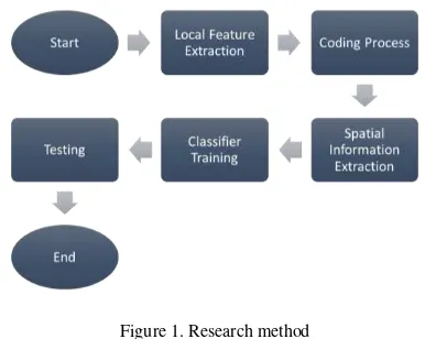
classes have 100 images, so there are 2100 images based on sparse features. Moreover, the process is continued to the fourth process, classifier training. The final process is testing the performance of our model. Each step will be described below.
Local Feature Extraction codebook is set by 1024. Output of this process is descriptor of each patches from the image. Base Sparse Coding, Locality constrained Linear Cod-ing, and Hard Quantization method on the coding quality for feature representation in classification task, especially land use classification. The input is the descriptor result from the local feature extraction process. Each local feature will be mapped into sparse representation and locality. The sparse representation means approaching some values close to 0 so that only a few features
are active, whereas locality will provide the feature representation in linear form. This locality makes the final features linearly separated.
Spatial Information Extraction
The result of coding process is a code of local fea-ture for each patch. This result is lacked of spatial information. To address this problem, we used Spatial Pyramid Matching (SPM) method [18]. We divided the image into 3 types of region, 1x1, 2x2, and 4x4. In the 1x1 region, spatial infor-mation is extracted on hole image. In the 2x2 region, image will be divided into 4 regions, and 16 regions for 4x4 region type. The function of this division is to eliminate redundant coding features. The input to extract spatial information from the data is the result of the coding process. Then, the result of this partition will be made into one array 1 and the data is ready to be trained using a classifier.
Classifier Training
The classifier used to classify data is the Support Vector Machine (SVM) classifier. Research [13-15] also uses this method as a classification fluence of data training number.
Classification Accuracy
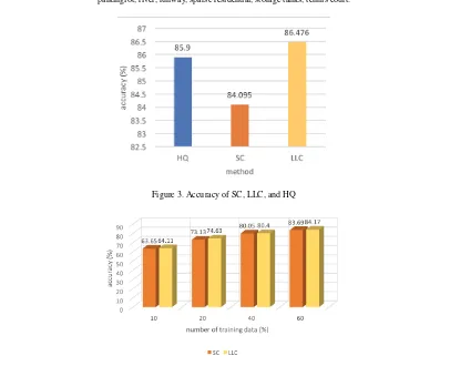
In here, we divided the training and testing data with ratio 4:1 for each classes. The result can be seen in Figure 3. From this result, LLC performed better than SC and HQ. Because of we used linear classifier, this result proves that LLC has better each coding method, the researcher conducted an experiment using different amounts of trainer data. The amount of training data used is 10, 20, accuracy than using the SC method.
Analysis
From the measurement accuracy of the three methods, it can be seen that LLC has a better ability than SC or HQ. This proves that the
locality that is carried by LLC is important so that it can represent better data. When it comes to land use classification, it relates to the amount of data that can be used as training data. LLC also shows its ability better than SC using little data. However when compared to [16], the accuracy of
Figure 2. Example of each classes from UC Merced dataset. (a-v) agricultural, airplane, baseball diamond, beach, buildings, chaparral, dense residential, forest, freeway, golf course, harbor, intersection, medium residential, mobile homepark, overpass,
parkinglot, river, runway, sparse residential, storage tanks, tennis court.
Figure 3. Accuracy of SC, LLC, and HQ
LLC is lower. But high accuracy is followed by high complexity in model development.
4. Conclusion
This study has conducted a comparison between HQ, SC, and LLC methods. The measurement results show that LLC has better performance compared to HQ and SC. The number of training data used for the training also determines the accuracy. The more the number of train data, the more improved model recognition capabilities. The highest accuracy was obtained by LLC method of 86.476% for UC Merced dataset.
From the results of this study, it can be done further research which do boosting the method of coding to improve recognition performance. It can also inspect the possibility of other factors besides sparsity and locality that are important in the coding process.
References
[1] R. K. Jaiswal, R. Saxena, and S.
Mukherjee, “Application of remote sensing
technology for land use/land cover change
analysis,” J. Indian Soc. Remote Sens., vol. 27, no. 2, pp. 123–128, Jun. 1999.
[2] J. Rogan and D. M. Chen, “Remote sensing technology for mapping and monitoring land-cover and land-use change,” Prog. Plann., vol. 61, no. 4, pp. 301–325, May 2004.
[3] Q. H. Weng, J. X. Zhang, P. Gamba, and
G. Xian, “Foreword to the issue on remote
sensing of regional land use and land
“Classification of pansharpened urban satellite images,” IEEE J. Sel. Topics Appl. Earth Observ. Remote Sens., vol. 5, no. 1, pp. 281–297, Feb. 2012.
[5] A. A. Ursani, K. Kpalma, C. C. D. Lelong,
and J. Ronsin, “Fusion
of textural and spectral information for tree crop and other agricultural cover mapping with very-high resolution satellite images,”
IEEE J. Sel. Topics Appl. Earth Observ. Remote Sens., vol. 5, no. 1, pp. 225–235, Feb. 2012.
[6] J. A. dos Santos, P. H. Gosselin, S. Philipp-Foliguet, R. D. Torres, and A. X. Falcao,
“Interactive multiscale classification of
high-resolution remote sensing images,”
IEEE J. Sel. Topics Appl. Earth Observ.
“Improved textural built-up presence index for automatic recognition of human settlements in arid regions with scattered
vegetation,” IEEE J. Sel. Topics Appl. Earth Observ. Remote Sens., vol. 4, no. 1, pp. 16–26, Mar. 2011.
[9] I. A. Rizvi and B. K. Mohan, “Object -based image analysis of highresolution satellite images using modified cloud basis function neural network and probabilistic
relaxation labeling process,” IEEE Trans. Geosci. Remote Sens., vol. 49, no. 12, pp. 4815–4820, Dec. 2011.
[10] R. Bellens, S. Gautama, L. Martinez-Fonte, W. Philips, J. C.-W. Chan, and F. Canters,
“Improved classification of VHR images of
urban areas using directional morphological profiles,” IEEE Trans. Geosci. Remote Sens., vol. 46, no. 10, pp. 2803–2813, Oct. 2008.
[1]] A. K. Shackelford and C. H. Davis, “A combined fuzzy pixel-based and object-based approach for classification of high-resolution multispectral data over urban
areas,” IEEE Trans. Geosci. Remote Sens., vol. 41, no. 10, pp. 2354–2363, Oct. 2003. [12] P. Gamba, F. Dell’Acqua, G. Lisini, and G.
Trianni, “Improved VHR urban area mapping exploiting object boundaries,”
IEEE Trans. Geosci. Remote Sens., vol. 45, no. 8, pp. 2676–2682, Aug. 2007.
[13] A. M. Cheriyadat, "Unsupervised Feature Learning for Aerial Scene Classification," IEEE Trans. Geosci. Remote Sens., vol 52, no. 1, Jan. 2014.
[14] Li-Jun Zhao, P. Tang, and Lian-Zhi Huo, "Land-Use Scene Classification Using a Concentric Circle-Structured Multiscale Bag-of-Visual-Words Model," IEEE Journal of Selected Topics in Applied Earth Observations and Remote Sensing, vol. 7, no. 12, Dec. 2014.
Classification," IEEE Trans. Geosci. Remote Sens., vol 53, no.4, April 2015. [16] F. Zhang, Bo Du, and L. Zhang,"Scene
Classification via a Gradient Boosting Random Convolutional Network Framework," IEEE Trans. Geosci. Remote Sens., vol. 54, no. 3, March 2016.
[17] C. Wang and K. Huang, "How to use Bag of Words Model Better for Image Classification," Image and Vision COmputing, vol. 38, pp. 65-74, 2015 [18] S. Lazebnik, C. Schmid, J. Ponce, Beyond
bags of features: spatial pyramid matching for recognizing natural scene categories, Computer Vision and, Pattern Recognition 2006, pp. 2169–2178.
[19] J. Yang, K. Yu, Y. Gong, T. Huang, Linear spatial pyramid matching using sparse coding for image classification, Computer Vision and Pattern Recognition 2009, pp. 1794–1801
[20] J. Wang, J. Yang, K. Yu, F. Lv, T. Huang, Y. Gong, Locality-constrained linear coding for image classification, Computer Vision and, Pattern Recognition 2010,pp. 3360–3367.