An Estimation of Earthquake Impact to Population in Makassar by
Probabilistic Approach
Bambang Sunardi* and Sulastri
Research and Development Center, Indonesia Meteorological Climatological and Geophysical Agency
Jl. Angkasa 1 No. 2 Kemayoran, Jakarta 10720
*)Corresponding author (e-mail: [email protected])
Abstract. 0DNDVVDU LV RQH RI ,QGRQHVLDQ ELJ FLWLHV ZLWK UDSLG JURZWK UDWH EXW QRW WRWDOO\ VDYHIURPHDUWKTXDNHKD]DUG7KLVFRQGLWLRQOHGVWXG\RQDIIHFWHGSRSXODWLRQE\HDUWKTXDNHV LQWKLVFLW\DUHLPSRUWDQWWRGR7KLVSDSHUHVWLPDWHGSRSXODWLRQRI0DNDVVDU&LW\WUHDWHQHG E\WKHSUREDELOLVWLFHDUWKTXDNHKD]DUG,QWKLVFXUUHQWVWXG\HDUWKTXDNHKD]DUGLQWKHIRUPV RISHDNJURXQGDFFHOHUDWLRQ3*$DQGVSHFWUDODFFHOHUDWLRQHVWLPDWHGE\XVLQJ3UREDELOLVWLF 6HLVPLF+D]DUGV$QDO\VLV36+$7KH36+$UHVXOWWKHQRYHUODLGZLWKDGPLQLVWUDWLRQPDS DQG SRSXODWLRQ GDWD WR REWDLQ GLVWULEXWLRQ DQG SHUFHQWDJH RI SRSXODWLRQ WKUHDWHQHG E\ WKH SUREDELOLVWLFHDUWKTXDNHKD]DUG7KHUHVXOWVVKRZHGWKHVPDOOHVWYDOXHRIJURXQGDFFHOHUDWLRQ ORFDWHGLQWKHVRXWKZHVW7DPDODWHVXEGLVWULFWIXUWKHUQRUWKLQFUHDVHGDQGUHDFKHGWKHKLJKHVW YDOXHLQWKHQRUWKHDVW%LULQJ.DQD\DVXEGLVWULFW%RWK7DPDODWHDQG%LULQJNDQD\DFDQEH FODVVLÀHGDVUXUDODUHDZLWKORZSRSXODWLRQGHQVLW\7KHXUEDQDUHDRI0DNDVVDUZKLFKLVWKH FRQFHQWUDWLRQRISRSXODWLRQORFDWHGLQWKHFHQWHURI0DNDVVDUJRWWKHPLGGOHHDUWKTXDNHKD]DUG
Keywords:HDUWKTXDNHKD]DUGUXUDODUHDXUEDQDUHDJURXQGDFFHOHUDWLRQ36+$.
Abstrak. 0DNDVVDUPHUXSDNDQVDODKVDWXNRWDGL,QGRQHVLDGHQJDQWLQJNDWSHUNHPEDQJDQ\DQJ SHVDWQDPXQWLGDNWHUOHSDVVDPDVHNDOLGDULDQFDPDQEDKD\DJHPSD.HDGDDQLQLPHQ\HEDENDQ SHQHOLWLDQWHQWDQJSHQGXGXN\DQJWHUDQFDPEDKD\DJHPSDGLNRWDLQLSHQWLQJXQWXNGLODNXNDQ 0DNDODK LQL PHPSHUNLUDNDQ SHQGXGXN .RWD 0DNDVVDU \DQJ WHUDQFDP EDKD\D JHPSD VHFDUD SUREDELOLVWLN'DODPSHQHOLWLDQLQLEDKD\DJHPSDGDODPEHQWXNSHUFHSDWDQWDQDKPDNVLPXP 3*$GDQVSHNWUDSHUFHSDWDQGLWHQWXNDQPHQJJXQDNDQ3UREDELOLVWLF6HLVPLF+D]DUG$QDO\VLV 36+$ +DVLO 36+$ VHODQMXWQ\D GL WXPSDQJVXVXQNDQ GHQJDQ SHWD DGPLQLVWUDVL GDQ GDWD NHSHQGXGXNDQKLQJJDGLSHUROHKSHUVHEDUDQGDQSHUVHQWDVHMXPODKSHQGXGXN\DQJWHUDQFDP JHPSD+DVLOSHQHOLWLDQPHQXQMXNNDQQLODLSHUFHSDWDQWDQDK\DQJUHQGDKWHUOHWDNGLDUDKEDUDW GD\D.HFDPDWDQ7DPDODWHNHDUDKXWDUDVHPDNLQPHQLQJNDWGDQPHQFDSDLQLODLWHUWLQJJLGL DUDKWLPXUODXW.HFDPDWDQ%LULQJNDQD\D%DLN.HFDPDWDQ7DPDODWHGDQ%LULQJNDQD\DGDSDW GLNODVLÀNDVLNDQVHEDJDLGDHUDKSHGHVDDQGHQJDQNHSDGDWDQSHQGXGXNUHQGDK'DHUDKSHUNRWDDQ 0DNDVVDU\DQJPHUXSDNDQSXVDWSHQGXGXNWHUOHWDNGLWHQJDK0DNDVVDUPHPSXQ\DLEDKD\D JHPSDPHQHQJDK
Kata kunci: EDKD\DJHPSDGDHUDKSHGHVDDQGDHUDKSHUNRWDDQSHUFHSDWDQWDQDK36+$.
1. Introduction
Makassar is the capital city of South Sulawesi province and the largest city in eastern Indonesia. It is located on the southwestern coast of Sulawesi Island. 0DNDVVDU LV WKH ÀIWK PHWURSROLWDQ LQ Indonesia, following Jakarta, Surabaya, Bandung and Medan. Makassar has a strategic position, because it is located at WKH FURVVURDGV RI WUDIÀF IURP VRXWK DQG north in Sulawesi Island, also from western to eastern regions and from northern and
southern regions of Indonesia. The total area of Makassar approximately 175.77 km2, includes 11 islands in Makassar Strait plus sea area of approximately 100 km² (makassarkota.go.id).
issued by BNPB (Ruswandi et. al., 2014). $OWKRXJK LWV HDUWKTXDNH GLVDVWHU ULVN FODVV LV moderate, Makassar has very decisive position in Indonesia development, especially in Eastern Indonesia. For this reason, study related to HDUWKTXDNHKD]DUGDQGULVNRI0DNDVVDUQHHG WREHGRQH9DULRXVVWXGLHVDERXWHDUWKTXDNH in Indonesia has been done, but many of them only focused on the physical aspect of HDUWKTXDNH3DQGLWDHWDO$OLIHWDO
9DULRXV VWXGLHV OLQNLQJ HDUWKTXDNH hazard and population have been conducted. 'HOO· $FTXD HW DO FRQGXFWHG D VWXG\ using remote sensing method to obtain spatial data of buildings and population to be used in the global exposure database for WKH PRGHOLQJ RI JOREDO HDUWKTXDNHV :DQJ HW al. (2012) connected the physical condition of the environment, social conditions and human expectations to calculate the capacity of the population (population carrying capacity / 3&&LQIDFLQJHDUWKTXDNH$OOHQHWDO created a shakemap atlas (in PGA form) and population exposure catalog, which the data FDQEHXVHGWRÀQGWKHGHJUHHRIYXOQHUDELOLW\ RIDFRXQWU\WRHDUWKTXDNHKD]DUG
Liu and Wang (2015) studied the differences LQ KXPDQ YXOQHUDELOLW\ WR HDUWKTXDNH KD]DUG between rural and urban areas. Rahman et al. (2015) combines physical and social factors in calculating the vulnerability of society to
HDUWKTXDNHVDQGÀUHV$UDDVVHVVHGWKH ULVN RI HDUWKTXDNH KD]DUG IRU WKH SRSXODWLRQ temporally. He divided into working days, holidays, Ramadhan, and busy days, also distinguished between day and night. This VWXG\LVPRVWVLPLODUWR*XSWDHWDOZKLFK connected the population and PGA values. 7KLVVWXG\LVDÀUVWVWHSLQGHWHUPLQLQJVHLVPLF vulnerability, human exposure, population carrying capacity and the determination of seismic risk.
This study aims to determine the population of Makassar City threatened by WKH SUREDELOLVWLF HDUWKTXDNH KD]DUG 7KH HDUWKTXDNH KD]DUGV ZLOO EH FDOFXODWHG DW peak ground acceleration (PGA) and spectral DFFHOHUDWLRQDWWZRVSHFLÀFSHULRGV7 DQG T=1 second. Generally, this study combines WZR W\SHV RI GDWD SUREDELOLVWLF HDUWKTXDNH hazard and population of Makassar.
2. Research Method
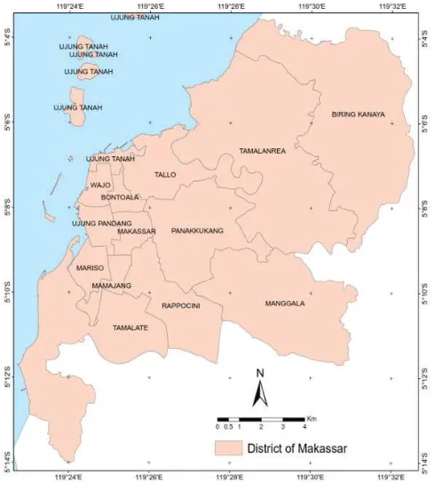
The area of study bounded by Makassar Strait in the west, Kepulauan Pangkajene in the north, Maros in the east and Gowa in the south. It is geographically located between Ļļ Ļļ (DVW DQG ĻļĻļ6RXWK7KHDUHDRIVWXG\ was shown in Figure 1.
Makassar City is part of Sulawesi Island. Based on their formation, this island can be divided into four zones, i.e. West Sulawesi, East Sulawesi, Banggai-Sula and Central Sulawesi. They were united in Miocene-Pliocene era caused by interaction between 3DFLÀF DQG $XVWUDOLDQ SODWHV WR $VLDQ SODWH (Kaharudin et al., 2011). The interaction of the three plates could be the cause of the geological GLVDVWHU LQ 6XODZHVL VXFK DV HDUWKTXDNHV tsunamis, volcanic eruptions and ground movements. There are at least 12 tectonic and VWUXFWXUDOHOHPHQWVWKDWFDQWULJJHUHDUWKTXDNH at Sulawesi, i.e Walanae fault, Makassar thrust, Lawanopo fault, Tolo thrust, Matano fault, Poso fault, Sula fault, Batui thrust, Palu Koro fault, Gorontalo fault, Sulawesi Sea subduction plate and Maluku subduction plate (Irsyam et al., 2010).
7R FDOFXODWH SUREDELOLVWLF HDUWKTXDNH KD]DUG ÀUVW VWHS LV LGHQWLI\ HDUWKTXDNH VRXUFHV ZKLFK LQÁXHQFH LQ 0DNDVVDU HLWKHU subduction, faults and background sources. 7KH QH[W VWHS LV FROOHFWLQJ HDUWKTXDNH GDWD KDYLQJWKHVHFULWHULDPDJQLWXGH0ZDQGD maximum radius of 500 km from Makassar. It ZDV XQGHU DVVXPSWLRQ WKDW HDUWKTXDNHV ZLWK magnitude Mw < 5 and a radius of over 500 km ZLOOQRWJLYHDVLJQLÀFDQWLPSDFWRUOHVVOLNHO\ to cause damage.
The data processing includes creating D KRPRJHQHRXV PDJQLWXGH HDUWKTXDNH data, separating the mainshock from its foreshocks and aftershocks, also analyzing WKH FRPSOHWHQHVV RI HDUWKTXDNH GDWD 7KH QH[W VWDJH LV HDUWKTXDNH VRXUFH PRGHOLQJ based on geological and tectonic conditions DQG FKDUDFWHUL]LQJ HDUWKTXDNH VRXUFH 3UREDELOLVWLF HDUWKTXDNH KD]DUG DQDO\VLV UHTXLUHGDSSURSULDWHDWWHQXDWLRQIXQFWLRQVIRU HDUWKTXDNH KD]DUGV DQDO\VLV DQG PDQDJLQJ uncertainty elements with logic-tree. By using DORJLFWUHHHDUWKTXDNHVRXUFHSDUDPHWHUVDQG attenuation models can be accommodated with appropriate weights.
(DUWKTXDNHKD]DUGDQDO\VLVZDVFRQGXFWHG using Probabilistic Seismic Hazards Analysis (PSHA), by using total probability concept &RUQHOODVGHÀQHGLQHTXDWLRQ
(1)
with fm is magnitude distribution function, fr is distance to hypocenter distribution function, 3[, L|m and r] is the conditional probability of intensity , that exceed the value
of i DW D UHYLHZHG ORFDWLRQ RI DQ HDUWKTXDNH
event with a magnitude M and distance to hypocenter R, and 3[, L] is the probability of intensity , that exceed the value of i. In this study, PSHA was analysis for 2% exceeded
SUREDELOLW\ LQ \HDUV RU HTXLYDOHQW ZLWK \HDUVHDUWKTXDNHUHWXUQSHULRGDGMXVWWR
modern seismic regulations as well as NEHRP
$6&(,%&DQG61,
which refers to ASCE 7 -10 (Imran, 2010).
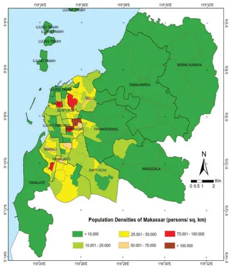
An overview of Makassar population in 2013 can be seen in Figure 2. We could see that the Makassar, Mariso and Mamajang sub districts got highest population density, while Biringkanaya, Tamalanrea and Manggala sub districts got the lowest density. According to these, Makassar, Mariso, and Mamajang can be
FODVVLÀHGDVXUEDQDUHDVZKLOH%LULQJ.DQD\D
Tamalanrea, and Manggala as rural areas.
2WKHUVXEGLVWULFWVFDQEHFODVVLÀHGVXEXUEDQ
areas, those are between urban and rural areas.
(DUWKTXDNH KD]DUG IRU 0DNDVVDU ZDV
determined by combining probabilistic
HDUWKTXDNH KD]DUG PDS ZLWK DGPLQLVWUDWLYH
map of Makassar. Administrative map derived from RBI map of Makassar 1: 25,000 Scale. This
SUREDELOLVWLFHDUWKTXDNHKD]DUGPDSLVEDVHG
on peak ground acceleration (PGA) and spectral
DFFHOHUDWLRQDWWZRVSHFLÀFSHULRGV7 DQG 7 VHFRQG UHVSHFWLYHO\ (DFK HDUWKTXDNH
hazard map generated will split Makassar City into several areas with different acceleration values, expressed in g (gravitational force of the earth).
Estimation number of people threatened
E\ WKH SUREDELOLVWLF HDUWKTXDNH KD]DUG
in Makassar is conducted by overlaying
HDUWKTXDNH KD]DUG PDS ZLWK SRSXODWLRQ
almost the same for all regions of Makassar, so even if calculations using population data in 2013, but it still can be applied for 2015.
Estimation number of people threatened E\HDUWKTXDNHVZDVFDOFXODWHGIRUHYHU\YLOODJH in Makassar. It is assumed that the population of each village distributed homogeneously, VR WR ÀQG WKH QXPEHU RI LQKDELWDQWV RI WKH village with different acceleration value used the comparison of area. For example, to search how many endangered populations of 0.1 g for village ', the formula used is as follows.
(2)
With 3(0.1 J) is the estimated number of people in Village ' threatened by 0.1 g HDUWKTXDNH KD]DUG$(0.1 J) is the area of
Village ' WKUHWHDQHG E\ J HDUWKTXDNH hazard, and $' is total area of Village '.
The last step is to state the estimated number of Makassar people threatened E\ HDUWKTXDNH KD]DUG LQ D SHUFHQWDJH )RU example, to state the percentage of estimated SRSXODWLRQWKUHDWHQHGE\HDUWKTXDNHKD]DUGRI 0.1 g, the formula used is as follow.
(3)
With E (0.1 J) is the estimated percentage of estimated population threatened by HDUWKTXDNH KD]DUG RI J 3 (0.1 J) is the total of estimated number of people threatened E\HDUWKTXDNHKD]DUGRIJDQG3 is the total population.
3. Results and Discussions
Figure 2. Population densities of Makassar City
Based on Makassar in Figures 2013, the SRSXODWLRQ RI 0DNDVVDU LV SHRSOH The population density per village of Makassar varies widely, ranging from 752 persons/ km2 to 258,000 persons/km2. The highest population density is in Makassar sub district and the lowest population density is in Biringkanaya sub district (northernmost). Population density of Makassar City was shown in Figure 2.
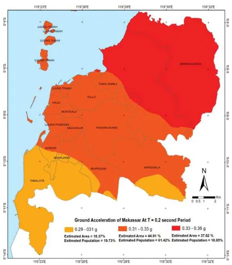
Spectral acceleration value at T = 0.2 VHFRQGVUDQJHGIURPWRJ7KHVWXG\ area was divided into three classes, i.e. area acceleration between 0.29 to 0.31 g, between WR J DQG EHWZHHQ WR J respectively. Spectral acceleration value at T = 0.2 seconds is the highest acceleration among all periods. Estimation of population WKUHDWHQHG E\ HDUWKTXDNH KD]DUG DW WKHVH conditions have a similar pattern to PGA result, but differ in percentage of the area and the percentage of population, as shown in Figure 4. Around 18.37% of area with relatively low acceleration spectra between 0.29 to 0.31 g, covered Tamalate, southern parts of Mariso, Mamajang, and Rappocini respectively. The percentage of population DIIHFWHG E\ HDUWKTXDNH KD]DUG DW DFFHOHUDWLRQ between 0.29 to 0.31 g approximately 19.73% of total population. Area with acceleration between 0.31 to 0.33 g reached 44.01%, included Ujung Tanah, Tallo, Wajo, Bontoala, Ujung Pandang, Makassar, Panakkukang, southwest of Tamalanrea, most of Manggala, Rappocini, Mamajang and Mariso. The percentage of SRSXODWLRQ DIIHFWHG E\ HDUWKTXDNH KD]DUG with acceleration between 0.31 to 0.33 g was DSSUR[LPDWHO\RIWRWDOSRSXODWLRQ$UHD ZLWKDFFHOHUDWLRQEHWZHHQWRJUHDFKHG FRYHULQJ%LULQJ.DQD\DDQGQRUWKHUQ of Tamalanrea. The percentage of population
DIIHFWHGE\HDUWKTXDNHKD]DUGZLWKDFFHOHUDWLRQ EHWZHHQWRJDSSUR[LPDWHO\RI total population.
Spectral acceleration value at T = 1 second RI 0DNDVVDU UDQJHG EHWZHHQ WR J The study area also divided into three, i.e. area acceleration between 0.13 to 0.14 g, between 0.14 WRJDQGEHWZHHQWRJUHVSHFWLYHO\ as shown in Figure 5. At T = 1 second period, DERXW WKUHHTXDUWHUV RI WKH DUHD DQG WKUHH TXDUWHUV RI WKH SRSXODWLRQ LV WKUHDWHQHG E\ HDUWKTXDNH KD]DUG EHWZHHQ WR J DQG WKH UHVW LQ GDQJHU RI HDUWKTXDNH KD]DUG between 0.13 to 0.14 g in the south, and between WRJLQWKHQRUWK$URXQGRI WKH SRSXODWLRQ DIIHFWHG E\ WKH HDUWKTXDNH hazard with acceleration between 0.14 to 0.15 g, covered Ujung Tanah, Wajo, Bontoala, Tallo, Tamalanrea, Panakkukang, Makassar, Ujung Pandang, mostly of Biring Kanaya, western of Manggala, northern parts of Rappocini, Mamajang and Mariso respectively. While RI SRSXODWLRQ DIIHFWHG E\ HDUWKTXDNH hazard with acceleration between 0.13 to 0.14 g covered Tamalate, southern of Rappocini and northeast of Manggala. The remaining 2.5% of WKHSRSXODWLRQDIIHFWHGE\HDUWKTXDNHKD]DUG DFFHOHUDWLRQVSHFWUDRIWRJFRYHUHGD small area of Biring Kanaya.
Figure 4. 6SHFWUDODFFHOHUDWLRQDW7 VHFRQGVHVWLPDWHGDUHDDQGD௺HFWHGSRSXODWLRQ
Figure 5.6SHFWUDODFFHOHUDWLRQDW7 VHFRQGHVWLPDWHGDUHDDQGD௺HFWHGSRSXODWLRQ
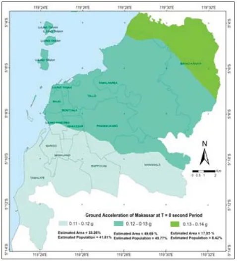
7KH SDWWHUQ RI SUREDELOLVWLF HDUWKTXDNH
hazard as shown in Figure 3, Figure 4 and Figure 5 showed low ground accelerations values in the south, especially in Tamalate sub district. Further north increased and reached the highest value in the north, in Biringkanaya sub district. The existence of Walanae fault in northeast Makassar is the
reason why PGA values relatively tend to rise toward northeast. Walanae fault is an active
IDXOW ORFDWHG DSSUR[LPDWHO\ NP IURP
Makassar City (Rante, 2015). The calculation result of maximum ground acceleration based on historical seismicity indicated that Walanae
IDXOW JDYH WKH KLJKHVW LPSDFW WR HDUWKTXDNH
around Makassar City (Makassar thrust, Lawanopo fault, Matano fault, Poso fault, Palu-Koro fault).
Both Tamalate and Biring Kanaya sub districts are rural areas, but the Tamalate got the lowest and Biringkanaya got the highest VHLVPLFJURXQGDFFHOHUDWLRQ7KHFRQFHTXHQF\ is that the Biringkanaya people should build WKH PRUH UHVLVWDQW EXLOGLQJ WR HDUWKTXDNH LI WKH\ZDQWWRPLQLPL]HWKHHDUWKTXDNHLPSDFWV 7KH HGXFDWLRQ DERXW HDUWKTXDNH KD]DUG LWV impacts, and how to minimalize the effects should be given, especially to people in Biringkanaya.
The urban areas which are located next to the FHQWUDORI0DNDVVDUJRWWKHPHGLXPHDUWKTXDNH hazard, when compared with other areas in Makassar. For a growing city like Makassar, it needs spaces for the regional development. To minimize the the cost of buildings and other facilities, the city development should expand to Tamalate. If there is another consideration about the city developmet, in another words
if the city development move to Biringkanaya, more costs are needed to make a more resistant building.
4. Conclusion
Study on estimation of Makassar City population threatened by probabilistic HDUWKTXDNH KD]DUG RYHUOD\ PHWKRG RI SUREDELOLVWLF HDUWKTXDNH KD]DUGV PDS DQG population data successfully performed on peak ground acceleration (PGA), spectral acceleration at period T=0.2 seconds and T=1 second respectively. Each result gave different acceleration values, but have a similar pattern, i.e. a low acceleration values lies in the south, especially in Tamalate sub district. Further north increased and reached the highest value in the sub district Biringkanaya. Other conclusions is urban area of Makassar which is the concentration of the population, UHFHLYHGWKHPHGLXPHDUWKTXDNHKD]DUGZKHQ compared with other areas in Makassar City.
6. References
$OLI600HLODQR,*XQDZDQ((IHQGL-(YLGHQFHRI3RVWVHLVPLF'HIRUPDWLRQ6LJQDO RIWKH0%HQJNXOX(DUWKTXDNHDQGWKH0,QGLDQ2FHDQ(DUWKTXDNHLQ Southern Sumatra, Indonesia, Based on GPS Data. Journal of Applied Geodesy 10, 103–108.
Allen, T. I., Wald, D. J., Earle, P. S., Marano, K. D., Hotove c, A. J., Lin, K., Hearne, M. G. (2009) $QDWODVRIVKDNHPDSVDQGSRSXODWLRQH[SRVXUHFDWDORJIRUHDUWKTXDNHORVVPRGHOLQJ%XOO (DUWKTXDNH(QJ. 7, 701-718
$UD6,PSDFWRIWHPSRUDOSRSXODWLRQGLVWULEXWLRQRQHDUWKTXDNHORVVHVWLPDWLRQDFDVH study on Sylhet, Bangladesh. ,QW-6FL'LVDVWHU5LVN
&RUQHOO &$ (QJLQHHULQJ 6HLVPLF 5LVN $QDO\VLV %XOOHWLQ RI WKH 6HLVPRORJLFDO 6RFLHW\ RI$PHULFD. Vol. 58, pp.
'HOO·$FTXD) Gamba, P., Jaiswal, K. (2013) Spatial aspects of building and population exposure RIGDWDDQGWKHLULPSOLFDWLRQVIRUPRGHOLQJJOREDOHDUWKTXDNHH[SRVXUH 1DW+D]DUGV 1291-1309
Gupta, I., Sinvhal, A., 6KDQNDU5+LPDOD\DQSRSXODWLRQDWULVNVWUDWHJLHVIRUHDUWKTXDNH preparedness. 'LVDVWHU3UHYHQWLRQDQGManagement. Vol. 15, No.
3DQGLWD+6XNDUWRQR6,VMXGDUWR$*HRORJLFDO,GHQWLÀFDWLRQRI6HLVPLF6RXUFHDW2SDN )DXOW%DVHGRQ6WUDWLJUDSKLF6HFWLRQVRIWKH6RXWKHUQ0RXQWDLQV)RUXP*HRJUDÀ² Imran, I., and Boediono, B. (2010) :K\ZHFROODSVHGEXLOGLQJVDWHDUWKTXDNH. Shortcourse IPR, Jakarta. Irsyam, M., Sengara I.W., Adiamar, F., Widiyantoro, S., Triyoso, W., Natawidjaja, D.H., Kertapati,
E., Meilano, I., Suhardjono, Asrurifak, M., and Ridwan, M. (2010) VXPPDU\RIVWXG\UHYLVLRQ WHDPHDUWKTXDNHPDS,QGRQHVLD, Bandung.
/LX-DQG:DQJ6$QDO\VLVRIWKHGLIIHUHQWLDWLRQLQKXPDQYXOQHUDELOLW\WRHDUWKTXDNH KD]DUGVEHWZHHQUXUDODQGXUEDQDUHDVFDVHVWXGLHVLQ:HQFKXDQ(DUWKTXDNH DQG<D·DQ(DUWKTXDNH&KLQD-+RXVDQGWKH%XLOWEnviron. 30, 87-107
MakassarKota.go.id *HRJUDÀV .RWD 0DNDVVDU, [online], from: http://makassarkota.go.id/110-JHRJUDÀVNRWDPDNDVVDUKWPO>6HSWHPEHU@
Rahman, N., Ansary, M. A., ,VODP,*,6EDVHGPDSSLQJRIYXOQHUDELOLW\WRHDUWKTXDNH DQGÀUHKD]DUGVLQ'KDNDFLW\%DQJODGHVK,QWHUQDWLRQDO-RXUQDORI'LVDVWHU5LVN5HGXFWLRQ.13, 291-300.
Rante, R. (2015) Mikrozonasi bahaya kegempaan Kota Makassar berbasis data seismik dan data geoteknik. Thesis, Hasanudin University.
Ruswandi, D., Kurniawan, L., Triutomo, S., Yunus, R., Amri, M. R., Hantyanto, A., Linawati, E., Ghozalba, F., Wulandari. A., Nugroho, P. C., Kumalasari, N., Yulianti, G., Rozita, E., Wulandari, D.W. S., Ichwana, A. E. (2014) ,5%,'LVDVWHU5LVN,QGH[,QGRQHVLDLQ Directorate Reduction Disaster risk Deputy Prevention and Preparedness, West Java.
Standard ASCE ASCE / SEI 2010. 0LQLPXP'HVLJQ/RDGVIRU%XLOGLQJVDQG2WKHU6WUXFWXUHV(ASCE 7-10). Virginia.