HARMONISATON INITIATIVES OF COPERNICUS DATA QUALITY CONTROL
Fabio D. Vescovia, Thomas Lankestera, Emma Colemana, Giuseppe Ottavianelliba
Airbus Defence and Space, Europa House, The Crescent, Farnborough, GU14 0NL - UK – [email protected] b
European Space Agency, ESA/ESRIN Via Galileo Galilei Casella Postale 64 00044 Frascati (Roma) - Italy
KEY WORDS: Copernicus, Data Harmonisation, Quality Control.
ABSTRACT:
The Copernicus Space Component Data Access system (CSCDA) incorporates data contributions from a wide range of satellite missions. Through EO data handling and distribution, CSCDA serves a set of Copernicus Services related to Land, Marine and Atmosphere Monitoring, Emergency Management and Security and Climate Change.
The quality of the delivered EO products is the responsibility of each contributing mission, and the Copernicus data Quality Control (CQC) service supports and complements such data quality control activities. The mission of the CQC is to provide a service of quality assessment on the provided imagery, to support the investigation related to product quality anomalies, and to guarantee harmonisation and traceability of the quality information.
In terms of product quality control, the CQC carries out analysis of representative sample products for each contributing mission as well as coordinating data quality investigation related to issues found or raised by Copernicus users. Results from the product analysis are systematically collected and the derived quality reports stored in a searchable database.
The CQC service can be seen as a privileged focal point with unique comparison capacities over the data providers. The comparison among products from different missions suggests the need for a strong, common effort of harmonisation. Technical terms, definitions, metadata, file formats, processing levels, algorithms, cal/val procedures etc. are far from being homogeneous, and this may generate inconsistencies and confusion among users of EO data.
The CSCDA CQC team plays a significant role in promoting harmonisation initiatives across the numerous contributing missions, so that a common effort can achieve optimal complementarity and compatibility among the EO data from multiple data providers. This effort is done in coordination with important initiatives already working towards these goals (e.g. INSPIRE directive, CEOS initiatives, OGC standards, QA4EO etc.).
This paper describes the main actions being undertaken by CQC to encourage harmonisation among space-based EO systems currently in service.
1. INTRODUCTION
1.1 State of the Art
As there is an increased use of digital maps and spatial data within the user community, clear definitions of contents, structures, data processing and functions are increasingly needed. These definitions are expected to build a common language, uniform among missions and understood in an unambiguous way by users. The need for harmonising and standardising such common language is currently only partially covered by international standards (e.g. ISO, OGC, etc.). Depending on contextual use and external factors, these definitions can vary in some cases also significantly, thus causing confusion and eventually loss of interest among the users towards the use of advanced geographic technologies and EO data (Ziegler and Dittrich, 2004). In view of this risk, it is generally agreed that there is a need for harmonisation in the Earth Observation industrial and scientific sectors and in the geographical information context at large.
Geodata harmonisation implies and means the possibility to combine data from heterogeneous sources into seamlessly integrated, consistent and unambiguous information products, in an easy and repeatable way, adapted to the end-user’s requirements and context. (Schulze Althoff and Giger 2009)
This is essential not only for data integration and/or exchange between systems but also when migrating data from different sources across boundaries within EU countries and outside Europe (Giger and Schulze Althoff, 2012).Inconsistencies between spatial data are present across many areas, causing
divergence in data storage and functions. Heterogeneity is present within the following aspects:
Data format (Ziegler and Dittrich, 2004)
File data/conceptual model: structure and constraints Metadata model (OGC, 2010)
Data collection procedures
Spatial reference system / projections
Nomenclature, classification, taxonomy, terminology, thesaurus, ontology (Tikunov et al. 2008)
Zooming functionalities, scale, amount of detail displayed (A. Kuijper, 2009)
Portrayal (legend/classification, style)
Parameters, formulas, algorithms and relevant processing functions
A number of initiatives have already been launched to tackle one or more of the above-mentioned aspects. The following paragraphs summarise the most relevant of these.
build better capacities of knowledge and management of our planet (Gore 1999).
At European level, the process to geo-information sharing and integration is led by the guidelines contained in the INSPIRE Directive of the European Union (Villa et al. 2012). The INSPIRE Directive consists of a regulation framework for European geodata aiming at enforcing the use of best practices and integrated interfaces for the benefit of users and enterprises. A rich body of online literature is already available on this topic (the Authors refer to the links quoted in the Bibliography under “INSPIRE online literature”).
The Quality Assurance Framework for Earth Observation (QA4EO), endorsed by the Committee on Earth Observation Satellites (CEOS) as a contribution to facilitate the GEO vision for a Global Earth Observation System of Systems (GEOSS). QA4EO encompasses a framework and set of ten key guidelines, derived from best practices and with example templates included to aid implementation. Each GEO stakeholder community should be responsible for its own overall governance within the framework (GEO, 2010). RISE was an FP6 project with the aim to produce methodologies and guidelines for the creation of geodata specifications consistent with the international and industrial standards. In such context Europe may meet its needs for a sustainable and interoperable functioning of GMES (now Copernicus) services within the INSPIRE principles. An outcome of the RISE project (Eriksson and Hartnor, 2006; Portele, 2006) was the provision of a general data harmonisation methodology that can be applied to spatial data, through the development of harmonised product specifications. Besides these proposed standards which can be considered now well-established, there are various areas where standardisation has not come very far yet or where there are multiple competing standards (Ziegler and Dittrich 2004). In addition, all those efforts in the field of geodata harmonisation approach have tackled only one harmonisation issue at a time (e.g. schema mapping, catalogue search services, language translation and ontology). The HUMBOLDT project delivered a framework that is both a theoretical one and a framework of software tools that can handle the harmonisation process as a whole, tackling multiple harmonisation issues as instances of the same overall harmonisation process (Villa et al. 2012). The project focused on the objective of enabling harmonisation instances which were not covered by existing standardised procedures (Villa et al. 2008).
Other projects dealt mainly with ontological issues, as for example the HarmonISA-project (Hall 2006) that aimed at developing a set of tools to semi-automatically integrate different land-use datasets through an expert-driven approach supported by the used and developed software such as ontology editors.
1.2 Role of Copernicus Quality Control (CQC)
In the frame of the Copernicus Space Component Data Access (CSCDA), where a range of satellite missions deliver products and services to Copernicus user community, the Copernicus Quality Control (CQC) service is responsible for the quality assessment of the data delivered by the contributing missions. The data quality of each single product delivered remains the responsibility of the contributing missions however.
This paper focus on one of the tasks assigned to the CQC called “Task 7 - Harmonisation”: to suggest and eventually provide harmonisation to data, parameters, names and functionalities among the different satellite data providers (CCMEs).
The CQC mission can only be successfully accomplished by handling the various harmonisation issues as a whole and tackling them as instances of the same overall harmonisation process. In this context the CQC Team apply two approaches: a “holistic” approach and a standardisation approach.
1.“Holistic” approach. The CQC Team is aware that the different Copernicus components have constant interactions on-going with one another. Ideally they should inter-operate in a harmonious fashion like the many organs of one body so that whatever modification is done on one part may affect all related parts. For example, if a new name of a certain product is required by the stakeholders to ease its understanding, the up-stream processing chains which process, generate and archive that product must be accordingly modified. In turn, the down-stream Copernicus user interface for searching, ordering and retrieving that product (typically based on WMS technologies) is impacted and this, in turn, cascades on the users’ archive facilities, folders, naming conventions and eventually on the users’ language used for the published literature and general communications. The need for harmonising this complex mix of human factors, IT infrastructures and dedicated software can be addressed only by means of a “holistic” approach which considers these complexities as a “whole”, i.e. a complex unit composed of multiple elements inter-acting one another. Any action aiming at building a harmonious set of conventions (naming, standard processes, etc.) is unlikely to work on the overall complex Copernicus structure unless an appropriate study of the relevant end-to-end chain is carefully accomplished.
2. Standard approach. This approach takes advantage of the rich legacy of European and internationally acknowledged standards already created and well established. All CQC harmonisation initiatives will be inscribed in the frame of reference of initiatives (e.g. INSPIRE, OGC, QA4EO) as reported in the “State-of-the-Art” paragraph of this paper.
In the following paragraphs examples of harmonisation initiatives are presented for the following identified areas of inconsistencies among the CCMEs:
Processing levels
Cloud measures reported in metadata Acquisition Mode naming
Definitions of acquisition angles
2. PROCESSING LEVELS
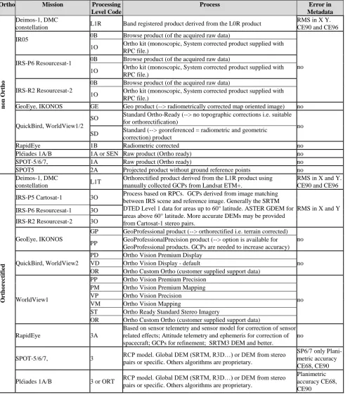
This harmonisation initiative deals with one of the most addressed issues of the users: the image processing levels are differently defined across CCMEs. The processing levels (in some cases called “Product Types”) refer mostly to the series of geometric and radiometric corrections that the image undergoes from its native format to its downstream processes. This CQC initiative will deal only with geometric corrections involved (e.g. geolocation process, orthorectification, etc.) Three aspects are considered not consistent within the geometric processing levels: their naming convention (codes), the processing methods and the associated errors.
geometric accuracy defined by the relevant precision error, which should be duly reported in the metadata. But this error can be reported as Root Mean Square (RMS) error (i.e. X and Y separately) and/or Directional Root Mean Square (DRMS) error (i.e. for one direction) and/or Circular Error (CE) or Planimetric Accuracy Measurement. Additionally the processing level code (e.g. L1R, L1B, etc.) is also heterogeneous across CCMEs products.
Table 1 summarizes all this across the CCMs. The various definitions of processing level codes, geometric correction
processes, geometric errors are listed. Note that this table reflects the current Authors’ understanding and may not contain some elements which the CCMEs should like to see included. Even though
Table 1 is neither meant to convert definitions into one another nor to identify any “best option” among many, it offers an overview at a glance of the diversities among the different CCMEs. A collection of differences is the baseline to compare them and discover similarities. Potentially, a common geolocation policy can be inferred and eventually proposed.
Ortho Mission Processing Level Code
constellation L1R Band registered product derived from the L0R product
RMS in X Y. CE90 and CE96
IR05 0B Browse product (of the acquired raw data)
no 1O Ortho kit (monoscopic, System corrected product supplied with
RPC file.)
IRS-P6 Resourcesat-1 0B Browse product (of the acquired raw data)
1O Ortho kit (monoscopic, System corrected product supplied with RPC file.)
IRS-R2 Resourcesat-2
0B Browse product (of the acquired raw data)
1O Ortho kit (monoscopic, System corrected product supplied with RPC file.)
GeoEye, IKONOS GE Geo product (--> radiometrically corrected map oriented image) no
QuickBird, WorldView1/2
SO Standard Ortho-Ready (--> no topographic corrections i.e. suitable for orthorectification)
no SD Standard (--> georeferenced = radiometric and geometric
correction) product
RapidEye 1B Radiometric corrected no
Pléiades 1A/B 1A or SEN Raw product (Ortho ready) no
SPOT-5/6/7, 1A Raw product (Ortho ready) no
SPOT5 2A Projected product without ground reference points no
O
Orthorectified product derived from the L1R product using manually collected GCPs from Landsat ETM+.
RMS in X and Y. CE90 and CE96
IRS-P5 Cartosat-1 3O Process based on RPCs. GCPs derived from image matching between IRS scene and reference image. Generally the SRTM DTED Level 1 data for areas up to 60° latitude. ASTER GDEM for areas above 60° latitude. More accurate DEMs may be provided from Cartosat-1 stereo pairs.
RMS in X and Y IRS-P6 Resourcesat-1 3O
IRS-R2 Resourcesat-2 3O
GeoEye, IKONOS
GP GeoProfessional product (--> orthorectified i.e. terrain corrected) no PP GeoProfessionalPrecision product (--> option is available for
GeoProfessional products. GCPs are needed to increase accuracy)
QuickBird, WorldView2
PD Ortho Vision Premium Display
no VD Ortho Vision Display - default
OR Ortho Custom Ortho (customer supplied support data)
WorldView1
PP Ortho Vision Premium Precision
no PM Ortho Vision Premium Mapping
VP Ortho Vision Precision VM Ortho Vision Mapping
ST Ortho Ready Standard Stereo Imagery
OR Ortho Custom Ortho (customer supplied support data)
RapidEye 3A
Based on sensor telemetry and sensor model for correction of sensor related effects; Attitude telemetry and ephemeris for correction of spacecraft; GCPs for refinement; SRTM3 DEM and better.
no
SPOT-5/6/7, 3 RCP model. Global DEM (SRTM, R3D…) or DEM from stereo pairs or specific. Others algorithms are proprietary.
SP6/7 only Plani-metric accuracy CE68, CE90
Pléiades 1A/B 3 or ORT RCP model. Global DEM (SRTM, R3D…) or DEM from stereo pairs or specific. Others algorithms are proprietary.
Planimetric accuracy CE68, CE90
3. REPORTING CLOUD MEASURES
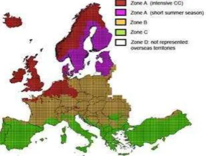
For certain projects in Copernicus services (e.g. CORE projects) a maximum cloud coverage allowed for the delivered imagery is contractually defined. These maximum limits, defined in DWH (2014) under REQ-5.3.3-6 Cloud Cover and Haze, are different depending on the climatic zones illustarted in Figure 1. The following three zones are identified for Europe:
Zone A (cloudiest): 20% max Zone B (cloud prone): 10% max Zones C/D (limited cloud): 5% max
Even though not contractually required also cloud shadows, smoke and contrails may be relevant for the user. In some cases also the location of clouds may be relevant: e.g. some land cover mapping projects may be unaffected by the clouds over the sea.
Given these contractual and technical requirements for cloud coverage it is important to define a commonly agreed method to detect cloudy/hazy pixels and a common unit (percentage?) to express this metric in the metadata.
Table 2 collects, across Copernicus optical missions, the information reported in the product metadata, in the users’ manual, in the cloud mask (if available) and other information relevant to clouds.
Figure 1. Zone map of maximum accepted cloud / haze coverage in Europe (from DWH, 2014).
Mission Value reported in
metadata Description from Product Manual
Cloud
Mask Other than Cloud
Deimos-1
No No mention of any masks in the
product manuals No
No cloud shadow DMC constellation
IKONOS
Reported in 2 spots: “% cloud cover” and “% component cloud cover"
Product manual for IKONOS and GeoEye say cloud % reported for all products except level s 5 and 7
No N/A
GeoEye Yes, percentage
QuickBird Yes, fraction. 999 if not assessed.
A definite boundary between the affected pixels and the unaffected pixels must be visible. Assessment based on either AOI or whole scene depending on the order.
provided
on request No cloud shadow
WorldView1/2 Yes, exponential Simple comment saying that an automated CCA tool is used
RapidEye Yes, percentage
Automatic tool provides Unusable Data Mask (UDM). Product includes clouds. Visual inspection assessment for errors due to inclusion of snow/ice/ bright surfaces). Darker or popcorn clouds may be undetected.
Yes, in TIFF
No haze/cloud shadow
PROBA-V Yes, percentage
Clouds mapped by 12s difference b/w NIR and SWIR. Cloud mask derived from SPOT-VGT (Lissens et al. 2000)
Derived from SPOT-VGT
Indicators for clear, cloud, ice, shadows and
undefined.
ResourceSat-1/2 No No mention of methods Yes
Manual judgement in 10% steps per quarter scene (unshifted)
Pléiades 1A/1B
No Cloud Vector Mask provided, filename beginning "CLD_"
Yes, in GML format
Automatically estimated with radiometric and geometric models. Manually corrected and snow masks added. SPOT6
SPOT5 No No mention No No
4. ACQUISITION MODE NAMING
Optical data may have various acquisition modes depending on the sensor spectral arrangements. In addition, different algorithms can be applied to generate different products. For example a multispectral sensor and a panchromatic sensor may be delivered together in one product package commonly called “Bundle”. In turn, the two single products included in a Bundle (i.e. the multispectral and the Panchromatic), if processed together, generate another product called “Pansharpened” which may be composed of three or four bands. Therefore, depending on their composition, the different product packages delivered to the market must have various product names and product codes across the CCMs.
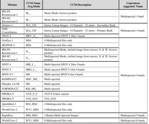
Table 3 reports an example of this situation just for the Multispectral products. The CQC Team is working on similar matrices also for other product categories such as Pansharpened, Panchromatic and Bundle. The second column
(CCM Name -Acq.Mode) lists the acquisition mode codes used by the CCMs to identify their multispectral products, whereas their relevant description is reported in the third column. The convention suggested in Copernicus groups the many names within a category using one descriptive name. Furthermore, the use of acronyms is minimised (e.g. Multispectral instead of MS)
The aim of this comparison matrix is not to uniform all code names in one name because the codes are part of configuration files which control many automatic processes in the CCM facilities. As these impact on the overall Copernicus system the different Acquisition Modes are not expected to be renamed easily within the CCM internal systems. The names suggested here are just intended to be part of an intuitive language which can be used in the context of Copernicus tools and web interfaces.
Mission CCM Name
-Acq.Mode CCM Description
Copernicus suggested Name
IRS-P6
Resourcesat-1 M__ Mono Mode, browse product
Multispectral 1 band IRS-R2
Resourcesat-2 M__ Mono Mode, browse product
Deimos-1 SL6_22S Surrey Linear Imager - 6 Channels - 22 metre - Secondary Bank
Multispectral 3 bands DMC
Constellation SL6_32P Surrey Linear Imager - 6 Channels - 32 metre - Primary Bank SPOT-4 HRV_X__ Multi-Spectral SPOT 4 20m 3 bands
GeoEye-1 MS4 4 Multispectral files only
Multispectral 4 bands IKONOS-2 MS4 4 Multispectral files only
IRS-P6
Resourcesat-1 X__
Multispectral Mode, stiched image from sensors 'A' & 'B', browse product
IRS-R2
Resourcesat-2 X__
Multispectral Mode, stiched image from sensors 'A' & 'B', browse product
SPOT-4 HIR_I__ Multi-Spectral SPOT 4 20m 4 bands
SPOT-5 HRG_J__ Multi-spectral SPOT 5 10m 4 bands
SPOT-6/7 MS Multi-spectral SPOT 6 6m 4 bands
KOMPSAT2 MSC_MS_ Multi-spectral
Pleiades 1A/1B MS Multi-spectral
FORMOSAT2 RSI_MS_ Multi-spectral
PROBA-V VGT_P_C VGT P Center camera
PROBA-V VG2_D10 VG2_D10
QuickBird-2 BGI_MS4 4 Multispectral files only
WorldView-2 WV1_MS4 4 Multispectral files only
RapidEye MSI_IMG 5-Bands Multi Spectral Imager Multispectral 5 bands
WorldView-2 WV1_MS8 8 Multispectral files only Multispectral 8 bands
Table 3. Comparison of multispectral product names/codes across different CCMs.
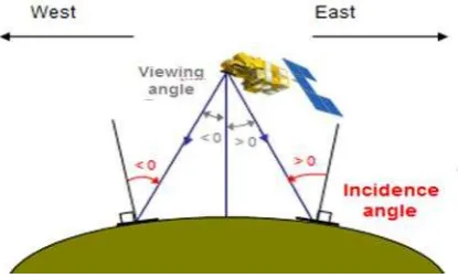
5. DEFINITIONS OF ACQUISITION ANGLES
The Acquisition angle is another disputed topic in some Copernicus services, especially among the Emergency users. Its definition refers actually to at least two angles: the Viewing angle and the Incidence angle. The former one is the angle from the instrument point of view. It represents the angle between the
look direction from the satellite and nadir and combines the platform pitch and roll angles. For this reason it is sometimes called also “combined angle”. The latter, Incidence Angle, is also widely used in the literature.
Figure 2. Representation of Viewing and Incidence angles (Courtesy of ASTRIUM DS France).
Table 4 lists the acquisition angles found in various scientific sources and in the literature documentation.
Angle name Source
Acquisition Generic
Collection Term mainly used for e-GEOS products Off nadir Generic, referred to Viewing angle
Viewing See
Figure 2 Incidence See
Figure 2
Combined Referred as Viewing angle. Term mainly used for ASTRIUM DS France products. Look angle Many Copernicus services and tools
Table 4. Definitions of acquisition angles from various sources.
6. CONCLUSIONS
The CQC harmonisation task seeks to ensure coordination to facilitate EO data consistency and interoperability across Copernicus communities and for the benefit of all stakeholders. Some of the organisations and international initiatives discussed in this paper may themselves be considered by broader EO representative communities as reference for “best practices” but would always be seen as living processes or documents that could, with time, be improved upon.
Unlike the organisations responsible for enforcing the best practice rules already in place in the EO community, the CQC task is not to create further standards or rules. It will provide support, guidance and, when relevant, capacity building towards the international quality framework already in place to facilitate harmonisation and interoperability of EO data, products and tools.
The issues presented in this paper refer only to some of the areas of inconstancies (e.g. processing levels, cloud measures, naming conventions and angles definitions) which characterize the CCMs and need to be harmonised. In general, the approach implemented by CQC for these and other harmonisation issues is strongly based on the rich legacy of European and international standards (e.g. INSPIRE, OGC, QA4EO) which just need to be implemented to uphold the interest of the overall Copernicus community and the commercial appeal of EO products and services.
REFERENCES
Eriksson, H. and Hartnor, J., 2006. Data harmonisation requirements (RISE project). Available from: http://www.eurogeographics.org/eng/documents/RISE13_Data_ Harmonisation_Requirements_v1.0.pdf [Accessed 20 April 2011].
GEO. A Quality Assurance Framework for Earth Observation: Principles. http://qa4eo.org/docs/QA4EO_Principles_v4.0.pdf 2010 [accessed 16 March 2015].
Giger C. and Schulze Althoff J. INSPIRE Anforderungen an Netzwerkdienste Unterschiede zu Vorgaben an Dienste in der Schweiz. Giger GeoIT (2012).
OGC: Open Geospatial Consortium Inc. OGC® Catalogue Services Standard 2.0 Extension Package for ebRIM Application Profile: Earth Observation Products. (2010)
Tikunov, V.S., Ormeling, F., and Konecny, M., 2008. Atlas information systems and geographical names information systems as contributants to spatial data infrastructure. International Journal of Digital Earth, 1 (3), 279_290.
Gore, A., 1999. The digital earth: understanding our planet in the 21st century. Photogrammetric Engineering and Remote Sensing, 65 (5), 528.
Grossner, K., Goodchild, M.F., and Clarke, K., 2008. Defining a digital earth system.Transactions in GIS, 12 (1), 145_160.
Hall, M., 2006. HarmonISA Land-Use viewer system: system documentation and handbook. HarmonISA. Available from: http://harmonisa.uni-klu.ac.at/
INSPIRE online literature:
Website: http://inspire-geoportal.ec.europa.eu/
Guidelines:http://eur-lex.europa.eu/LexUriServ/LexUriServ.do?uri=OJ:L:2007:108 :0001:0014:DE:PDF
Metadata: //MD_IR_and_ISO_20090218[1]-3219435009/MD_IR_and_ISO_20090218[1].pdf
Thematic Working Group Administrative units: http://inspire.jrc.ec.europa.eu/documents/Data_Specifications/ INSPIRE_DataSpecification_AU_v3.0.1.pdf
Thematic Working Group Cadastral Parcels: http://inspire.jrc.ec.europa.eu/documents/Data_Specifications/ INSPIRE_DataSpecification_CP_v3.0.1.pdf
Kuijper A. Transitions of a multi-scale hierarchical image descriptor, Second International Conference on Scale Space Methods and Variational Methods in Computer Vision (SSVM09, Voss, Norway, June 1 - June 5, 2009). LNCS 5567 pp. 844--855, 2009.
McKee, L., 2001. OGC’s role in the spatial standards world.
Technical report. Available from:
http://portal.opengeospatial.org/files/index.php?artifact_id6207 &version1&formatpdf
Villa, P., Gomarasca, M.A., and Reitz, T., 2008. HUMBOLDT project for data harmonization in the framework of GMES and ESDI: introduction and early achievements. International Archives of the Photogrammetry, Remote Sensing and Spatial Information Sciences, XXXVII (B4), 1741_1746.
Paolo Villa , Roderic Molina, Mario A. Gomarasca & Emanuele Roccatagliata (2012) Harmonisation requirements and capabilities towards a European spatial data infrastructure (ESDI): the HUMBOLDT protected areas scenario, International Journal of Digital Earth, 5:5, 417-438, DOI: 10.1080/17538947.2011.585183.
Ziegler, P. and Dittrich, K.R., 2004. Three decades of data integration all problems solved? In: IFIP congress topical sessions, building the information society, IFIP 18th world computer congress, topical sessions, 2227 August 2004, Toulouse, France, Kluwer, 312. 438 P.