cartography froM colony to nation
DECOLONIZING
THE MAP
Edited by
James R. Akerman
the university of chicago press chicago anD lonDon
Research
Use
The University of Chicago Press, Chicago 60637 The University of Chicago Press, Ltd., London
© 2017 by The University of Chicago All rights reserved. No part of this book may be
used or reproduced in any manner whatsoever without written permission, except in the case of
brief quotations in critical articles and reviews. For more information, contact the University of Chicago Press, 1427 E. 60th St., Chicago, IL 60637.
Published 2017.
Printed in the United States of America
26 25 24 23 22 21 20 19 18 17 1 2 3 4 5
isbn- 13: 978- 0- 226- 42278- 7 (cloth) isbn- 13: 978- 0- 226- 42281- 7 (e- book) Doi: 10.7208/chicago/9780226422817.001.0001
Library of Congress Cataloging- in- Publication Data
Names: Akerman, James R., editor. Title: Decolonizing the map : cartography from
colony to nation / edited by James R. Akerman. Other titles: Kenneth Nebenzahl, Jr., lectures in
the history of cartography.
Description: Chicago : The University of Chicago Press, 2017. | Series: Kenneth Nebenzahl, Jr., lectures in the history of cartography | Includes bibliographical references and index.
Identifiers: LCCN 2016030112 | ISBN 9780226422787 (cloth : alk. paper) | ISBN 9780226422817 (e- book)
Subjects: LCSH: Cartography— Political aspects. | Decolonization.
Classification: LCC GA108.7 .D44 2017 | DDC 526— dc23 LC record available at https:// lccn .loc .gov /2016030112
♾ This paper meets the requirements of ansi/niso z39.48– 1992 (Permanence of Paper).
Research
Use
CONTENTS
Acknowledgments · vii
INTRODUCTION
JaMes r. akerMan · 1
CHAPTER ONE
Cartography and Decolonization rayMonD b. craib · 11
CHAPTER TWO
Entangled Spaces: Mapping Multiple Identities in Eighteenth- Century New Spain
Magali carrera · 72
CHAPTER THREE
Cartography in the Production (and Silencing) of Colombian Independence History, 1807– 1827
lina Del castillo · 110
CHAPTER FOUR
Democratizing the Map: The Geo- body and National Cartography in Guatemala, 1821– 2010
JorDana DyM · 160
CHAPTER FIVE
Uncovering the Roles of African Surveyors and Draftsmen in Mapping the Gold Coast, 1874–1957
JaMie Mcgowan · 205
Research
Use
CHAPTER SIX
Multiscalar Nations: Cartography and Countercartography of the Egyptian Nation- State
karen culcasi · 252
CHAPTER SEVEN
Art on the Line: Cartography and Creativity in a Divided World suMathi raMaswaMy · 284
CHAPTER EIGHT
Signs of the Times: Commercial Road Mapping and National Identity in South Africa
thoMas J. bassett · 339
Contributors · 377 Index · 379
Research
Use
CHAP TER FOUR
DEMOCRATIZING THE MAP
the geo- boDy anD national cartography in guateMala, 1821 – 2010
Jordana Dym
Les limites de la république guatémalienne ne sont pas aussi faciles à déter-miner qu’on le croirait, en jetant les yeux sur la carte de ces régions.
philippe françois De la renauDière, Mexique et Guatemala (Paris: Firmin Didot Frères, 1843), 254– 55
Can a caricature of a map arouse nationalism, royalism, or other serious sen-timental responses?
thongchai winichakul, Siam Mapped, 138
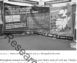
In July 2010, one bookseller at Guatemala’s annual book fair covered its stalls for the night with a banner by a group called “Convergence for Human Rights” (fig. 4.1). The banner called for the military to follow President Alvaro Colom’s order to open its archives and to end government impunity and cover- ups of genocide. The “Massacres” map of Guatemala accompanying the text on a blood- red background locates sites and tallies a dozen killings perpetrated
Research
Use
throughout national territory during over thirty years of civil war. Clearly, a Guatemalan at the book fair would see that the map shows the state acting against its people in communities located throughout the country, with both internal, departmental boundaries and external, international frontiers clearly marking the Guatemalan spaces affected by the conflict.
This map, then, implies not only a Guatemalan territory but also a Gua-temalan people. However, territory and people are less unified than the map seems to suggest. Guatemala officially claims Belize. Its Instituto de Geografía Nacional (IGN) legally holds a monopoly on making or approving maps of the national territory. Yet Belize is not part of this map’s territory, which lacks the IGN’s seal and authorization. Further, by placing the victims of armed conflict in both indigenous and ladino (Westernized) departments, the map blurs real ethnic and even class distinctions among victim communities, and also hides the country’s urban- rural divide.
Guatemala’s Maya population is generally considered the most grievously wounded by the conflict; hundreds of thousands were displaced or disap-peared, particularly in the country’s northwest highland districts. Instead of ethnic and regional distinctions, however, the fine print tallies the number of boys and girls caught up in the military’s murderous clutches, perhaps to make the point that the victims were innocent, no matter where or in what period of the conflict the murders took place. By emphasizing child victims and eliding
figure 4.1. Banner on display at FILGUA, July 2010. Photograph by the author.
Research
Use
problems of race and class, the map draws on the past and a common under-standing of what it means to be Guatemalan— having lived through and suf-fered in the civil war— while erasing some of the most salient features behind the conflict. So while seemingly representing a “done deal” and a common violation of human rights, this map also reveals the contingent in the fixed.
As French traveler and mining engineer Philippe de la Renaudière (1781– 1845) observed in 1843, “The limits of the Guatemalan republic are not as easy to determine as one might think, when casting an eye on a map of these regions.” Then, Guatemala lacked agreed boundaries with its neighbors and had already divided internally from seven (1825) into twelve departments (now twenty- two). Today, the comment still rings true. Guatemala has two geo- bodies, or national territories, the official and unofficial.1 Since the 1860s, the
most visible toggle has been with land: is Belize part of Guatemalan territory or not? Government and civil society have created both maps. Yet, as the 2010 book fair map shows, inclusion and exclusion of different Guatemalan popu-lations, particularly the indigenous majority, has been equally complicated. Language spoken is one of several strategies used to show and hide distinct na-tional and subnana-tional peoples.
This essay explores the long and complex process of establishing Guatema-la’s national geo- body and map, and the equally long experience of present-ing and teachpresent-ing them. It begins with the establishment of the state in 1825, follows a long nineteenth century of establishing and marking international boundaries and internal political and administrative divisions, and concludes in the twenty- first century as different groups adopt the competing geo- body territories and peoples, seemingly unconsciously, to establish their own claims to belong to and participate in Guatemalan debate and development.
I argue that over these two hundred years, a two- step process of “decol-onization” and “democratization” shaped the national territorial map. For Guatemala, decolonization occurred in two phases as the government iden-tified land and people over which it claimed sovereignty, representing that claim cartographically, and then successfully administering it. For the map to be fully decolonized, I suggest, the government must not only create na-tional maps, but also employ nana-tional agents and institutions to create maps considered “accurate” or correct both internally and externally. In Guatema-la’s case, the first national map based on work of a Guatemalan mapmaker and printed in Guatemala dates to 1832. However, full decolonization of the map happened in the early twentieth century, when the government developed a permanent and recognizable geo- body— “decolonizing” the land from an undefined shape whose internal districting slowly abandoned colonial
divi-Research
Use
sions to the wounded land seen in figure 4.1 with clear national and district boundaries— and assigned mapping to state- run cartography institutions. The second process, which I call “democratization” and Sarah Radcliffe considers “re- mapping the nation,” occurs when the tools of map reading and mapmak-ing become sufficiently widespread such that the government, regardless of any claim to hold an absolute monopoly on public mapmaking and consump-tion, is only one of many cartographic producers, and the nation also partici-pates in map production as well as consumption.2
The evidence is the map of the full national “geo- body” of Guatemala as it evolved from the nineteenth century to the early twenty- first century, including representation of Guatemalan citizens on that national space. For “decolonized” maps, the study relies on private and national archival sources. I supplement such sources for “democratized” maps with maps found through eBay and Internet browsing, and cameras of itinerant colleagues Karl Offen and Matthew Taylor, to offer a sense, however incomplete, of how private citizens have adapted the national geo- body for their own purposes. The evi-dence shows that the adoption of cartographic techniques and the internally divided geo- body by a range of actors in civil society, from authors of text-books to professional associations to telephone companies to indigenous labor movements to newspapers, reflects an active and effective appropriation of the geo- body for national as well as state purposes that had begun by the mid- nineteenth century and became increasingly widespread.
This argument owes much to Benedict Anderson’s understanding of mapmaking as a tool deployed by modern states— along with censuses and museums— not just to claim but also to demonstrate sovereignty over specific territories and peoples as part of a single imagined community.3 Beyond that, I
adopt Michel- Rolph Trouillot’s approach to underline the importance of dis-tinguishing between state and nation when talking about a truly “indigenous” map. Although Trouillot frames an argument about government acting against society in twentieth- century Haiti, the parallels he finds in a small country whose ethnic, racial, and economic divisions are arguably an extreme are a relevant model for Guatemala.4
Put in cartographic terms, for a map to be of the nation and not just of the state, I argue that the “imagined communities” themselves must accept the geo- body and use it in their own representations. This analysis concurs with Thongchai Winichakul’s insight that a map caricature or logo can “arouse nationalism, royalism, or other serious sentimental responses” even when it becomes a floating map (an outline on a blank background divorced from ter-ritoriality).5 It resonates with recent scholarship about the development of
Research
Use
nineteenth- century North and Spanish American national mapping, rise of national cartographic missions and later institutes, and development of school-book geographies with national maps.6 It also resonates with work of
geog-raphers like Sarah Radcliffe and Karl Offen on adoption and adaptation of national maps by “nonstate” actors, generally meaning disadvantaged popula-tions, through formal organizations like CONAIE in Ecuador and the Process of Black Communities in Colombia.7
There is no scholarly study of Guatemalan cartography from independence in 1821 to the present.8 However, there is increasing interest in both the historical
territory and its representation. Two informative twentieth- century govern-ment compilations, one prepared by the 1929 Limits Commission and the other engineer Florencio Santiso’s 1944 report to the second Pan- American meeting on geography and cartography, offer a chronological overview of cartographic development from codices to aerial surveys.9 More recently, Arturo Taracena’s
2002 analysis of Guatemala’s territorial formation traces the development of the national territory (and indirectly the geo- body) from 1821 and 1935.10
Fol-lowing cartographic and territorial development, this paper evaluates Guate-mala’s cartographic decolonization and democratization as taking place within three broad periods: forming the national body (1821– 1900), establishing na-tional cartographic institutions and the public presentation of the geo- body (1900– 1935), and proliferating and diversifying cartographic representations of the geo- body by both citizens and national agencies (1935– 2010).
MAPPING THE STATE OF GUATEMALA: HYBRID MAPS AND CARTOGR APHIC INDEPENDENCE (1821– 32)
Guatemala’s current geo- body has a distinctive shape with borders defined both by the jagged lines of natural features including oceans, rivers, and moun-tain ranges and carefully plotted straight lines and angles reflecting the mea-surements of boundary commissions (see fig. 4.1). That shape is neither nat-ural nor predestined. The fixing of national borders seems, today, to be an inevitable consequence of establishing sovereign societies, but as Alexander Diener argues, there is really nothing natural about a border or its features.11
Guatemala’s complex establishment of both internal and external borders is a case in point. Guatemalan governments spent much of the country’s first hundred years working with and against foreign powers to claim and mark international boundaries, largely through the work of border commissions and treaties. Concurrently, governments legislated to divide the country internally
Research
Use
to favor central control, rewarding regions that supported the national govern-ment while dividing and weakening districts, such as the western highlands, with breakaway movements or popular uprisings that tried to overthrow the central leadership.12 Cartographically, we can see the transition starkly by
com-paring a map showing the colonial divisions of Central America right before independence, which offers no preexisting shapes recognizable as the contem-porary national territory, with a twentieth- century silver charm whose outline is fully formed and instantly identifiable (figs. 4.2 and 4.3).
Within a decade Guatemala achieved first political independence from Spain and then initial cartographic independence, a two- map and one- geography process when it was a state in the short- lived Central American Federal Republic (1825– 39). The first map, by British envoy George A. Thompson, showed the overall shape of the country within the federation. A few years later, the geographic essays by Honduran- born statesman José Cecilio del Valle inspired Guatemala’s president to commission the first Guatemalan- made and Guatemalan- printed map from naturalized citizen Miguel Rivera Maestre. Together, these maps displayed Guatemala’s initial territorial shape and con-tent, both far from the iconic form that emerges at the end of the century.
By 1825, Guatemala was one of five federal states in the fledging repub-lic, forged from a half- dozen districts surrounding Guatemala City, Central America’s colonial capital.13 Guatemala’s initial seven “departments” are named
on the map produced in 1829 for diplomat Thompson’s travel narrative; it was the first map of both the state and the federation. Thompson credits Valle, a federal official, with helping trace the original map onto British cartographer Aaron Arrowsmith’s colonial map (probably fig. 4.2).14 Thompson’s map was a
hybrid of an imperial and a “decolonized” map: produced by foreigners who used local knowledge. Intended for an English- speaking public, Thompson’s map helped Europeans and Anglo- Americans visualize the outlines of Central America’s fledgling states, with brightly colored lines drawing attention to the new nation’s representation of international and state boundaries. Although the map’s subject is independent Central America, this map takes the pulse of Guatemalan geographic, commercial, and ethnographic understanding of na-tional territory and limits in 1826, as well as the already- extant focus on inter-nal divisions and the representation of Guatemala not just as an independent polity but also as situated within and as part of a Central American region.
On this map, Guatemala’s territory bears little resemblance to its twentieth- century geo- body. In the Petén area, not a single straight, surveyed line sep-arates Guatemalan from Mexican districts (resolved by treaty and survey in 1882) or from the British “establishment” of Belize (not resolved as of 2016).15
Research
Use
Guatemala’s internal divisions are named although not drawn by area; the miss-ing departmental lines suggest the limits to local knowledge or Thompson’s interest at that time; his local informant, José Cecilio del Valle, later claimed to have offered “negligible” input.16 Externally, two disputed districts, Sonsonate
and Chiapas, are drawn as separate from Guatemala but not yet part of Mexico. Perhaps most important for both Thompson’s intended British audience and Central American cartography, Belize’s territory is limited to the area autho-rized for logging in the 1786 treaty between Spain and the United Kingdom; later nineteenth- century maps by Guatemalan, Mexican, and British cartog-raphers all show Belize extending further south. In addition, the map empha-sized the outsider’s signal preoccupation with the Central American isthmus as a transit point for world commerce and a potential trading hub, a cartographic theme that Central American governments would soon pick up in their own cartography. Perhaps for that reason, the only indigenous peoples to appear on the map are the Caribbean Miskitu peoples who controlled territory not yet claimed by Honduras and Nicaragua.17 The Maya absence, whether by choice
figure 4.2. A. Arrowsmith, Map of Guatemala, London, 1826 (detail). Courtesy of the Library of Congress, Geography and Maps Division.
Research
Use
or oversight, tends to corroborate Valle’s disclaimer, since their presence was an integral element in his description of Guatemala’s cartographic past, present, and future.
In 1830, Valle’s detailed “geographic description” was serialized in the monthly bulletin of the country’s Sociedad Económica, an institution of mod-ernizing elites pushing development of Guatemala’s peoples and commerce. Valle’s chapters itemized the geographic position and elevation of each of Gua-temala’s seven departments alongside information on topography, languages, climate, population, agricultural production, and principal institutions and buildings.18 Valle highlighted Guatemala’s indigenous populations through
lin-guistics and history. Demographically, he discussed ethnic diversity through the thirteen indigenous languages spoken by people making up two- thirds of the country’s population. However, much like later reformers, he viewed native languages as “an obstacle opposed to the indios’ civilization, a wall of separation” distancing them from “cultured and enlightened men.”19 Not
inci-dentally, Valle insisted the country needed not one, but three maps, one for each stage of its history— pre- Columbian, colonial, and independent— each showing internal divisions of (respectively) kingdoms, provinces, and
depart-figure 4.3. Guatemala, 1951. Gua-temala’s national bird, the Quetzal, affirms the nationalist message in this map, as does inclusion of Belize, albeit with a line indicating division from the rest of the country. Private Collection.
Research
Use
ments. It seems likely that he wanted his data and view of indigenous history as Guatemalan history used for a map of “our actual state [and] the real location of the pueblos,” which, he argued, “should be brought to view to legislate and govern.”20 Valle anticipated historian Raymond Craib’s argument for mid-
nineteenth- century Mexico that without “a reliable national map,” a new gov-ernment “could hardly begin to conceive of, let alone carry out, any political reorganization of the territory.”21
Between them, Thompson and Valle created an agenda that Guatemalan governments would promote for official and popular maps. Although no nineteenth- century Guatemalan government created all three of Valle’s pro-posed maps, interest in geographic, historical, and ethnographic Guatemala became integral to subsequent official geographies and cartographies, as did the commercial and economic agenda seen in Thompson’s map and embedded in the extensive lists of departmental production in Valle’s geography text.
Shortly after Thompson’s visit and Valle’s geography, Guatemalan president Mariano Gálvez (1831– 38) essentially adopted Valle’s cartographic program. He commissioned histories of colonial and independent Central America from Francisco de Paula García Peláez and Alejandro Marure, respectively, and a Gua-temalan atlas by surveyor Miguel Rivera Maestre (1783– 1856), who apparently was already preparing a map for the Sociedad Económica.22 For most scholars,
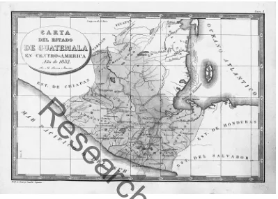
this 1832 Atlas guatemalteco, not Thompson’s collaboration, initiates Guatemala’s postcolonial cartography. It certainly achieves its cartographic independence.
The atlas was an ambitious first project, with one map of the state (fig. 4.4) and one of each of Guatemala’s seven departments filling in mountain-ous terrain. Although the initial atlas did not include maps depicting pre- Columbian and colonial territories, some copies add Rivera Maestre’s later state- commissioned maps of Maya archaeological sites.23 Lacking formal
car-tographic training, Rivera Maestre probably relied on existing maps of Central America and Valle’s “Descripción Geográfica” as well as other government- compiled statistics. Long- time residents José Casildo España and Francisco Cabrera engraved the atlas maps, which were printed in Guatemala.24
Focused on Guatemala’s internal divisions, Rivera Maestre’s department maps rendered mountains, cities, roads, and rivers visible; his state map showed the government its sovereign territory and reflected Guatemala’s tacit accep-tance of the loss of Sonsonate to El Salvador in 1824. The atlas was less success-ful in other areas, including technical proficiency and fixing external bound-aries. Historian Roger Claxton points to distortions from drawing equidistant parallels and meridians, misalignment of mountains in the department maps, and a host of other smaller errors.25
Research
Use
Guatemala’s lack of settled international boundaries is both visible and invis-ible. The line denoting the border with Honduras and El Salvador to the south seems firm, but there was no discussion of, let alone agreement on, the exact limits during the conflict- ridden federal period (1824– 39). Indeed, Honduras and Guatemala disputed the exact path of their borders for almost a hundred years.
The map, with a tentative and incomplete northern border, better captured ongoing uncertainty about Guatemala’s limits with Mexico, and the role the Maya played there, and with Belize. Chiapas effectively joined Mexico in 1823, rejecting Central American overtures to be the federation’s sixth state. Yet the map names it a “state” alongside El Salvador and Honduras. It is a subtle dig, since that identifier alone distinguishes Chiapas from the Mexican districts of Tabasco and Yucatán. Further, the map presents an “undefined boundary” with Yucatán, home of the “Lacandones” (a Maya people), and land south of the Tabasco boundary in the hands of “Los Mayas.” In other words, Rivera
figure 4.4. Miguel Rivera Maestre, Carta del Estado de Guatemala en Centro- América, Año de 1832. In
Atlas guatemalteco en ocho cartas formadas y grabadas en Guatemala. Engraved by José Casildo España (1778– 1848). Bibliothèque Nationale de France, Manuscrits Orientaux, MS Angrand- 12, p. 3.
Research
Use
Maestre consigns substantial territory between Totonicapán and Verapaz to peoples and areas seemingly beyond either country’s control.26 Valle’s
pre-occupation with indigenous people as not civilized, and speaking different languages, is presented by Rivera Maestre as a political rather than cultural or linguistic problem.
The map does suggest the beginning of a northern boundary with Belize in an incomplete line that shows Belize topographically united with Guatemala by river systems and roads. The name “Belize” hovers only to the north of the Sibún River, rendering invisible or ambiguous both British and Guatemalan claims to the area between the Sibún (northern) and Sarstún (southern) rivers with their British settlements.27 Overall, the map presents an amorphous
na-tional shape, which helps explain its importance both in 1832 and for govern-ments and scholars since; Rivera mapped what the government claimed, and left unsettled or ambiguous what was not clear.
Rivera Maestre’s atlas and map offered the first official cartography of inde-pendent Guatemala and fulfilled Valle’s agenda of showing the political divi-sions of the “actual state,” although without addressing the pre- Columbian or colonial cartographic content laid out in Valle’s treatise. The country map was the first national map published in Guatemala. Prepared by a (naturalized) Guatemalan, it reflected a governmental claim to a national territory that was adamant about internal authority, as demonstrated in the lines and words that identified and placed the country’s departments on the national territory, and by the decision to leave out the mountain elevations that figured prominently on the atlas’s departmental maps. Yet the map also showed awareness of lim-ited control over certain Maya peoples and lands and honestly depicted exter-nal, “undefined” limits with neighbors. Depicting political authority in a map designed to “be brought to view to legislate and govern” was the map’s prin-cipal claim, and it gave graphic form to state assertions of the right not only to defend a certain territory from external claims but also to divide the new state based on national interests. That is, Rivera Maestre’s atlas declared Guatemala’s cartographic independence.28
MAPPING THE REPUBLIC OF GUATEMALA (1850– 1900): FOREIGN EXPERTISE AND NATIONAL TEXTBOOKS
Within a decade after publication, the Rivera Maestre map, made for a fed-eral state and a compilation of others’ data, was out of date and outmoded, reduced to a point of departure. The federation dissolved in 1839, and
Guate-Research
Use
mala proclaimed itself a sovereign republic in 1847. The national government commissioned a new territorial map based on the mapmaker’s own on- the- ground travels to verify and measure with modern instruments the latitude and longitude of cities, rivers, and mountains. At first, this meant partial recol-onization and reliance on foreign expertise to collect, analyze, and print data in cartographic form. The late nineteenth century, in addition to recolonizing the Guatemalan map, also initiated its democratization, as semiofficial school geographies began to put the increasingly well- defined and delimited geo- body in the hands of citizens and schoolchildren. These official and semi official maps reflected also political developments, including decrees increasing the number of departments and treaties with Great Britain (1859) and Mexico (1882) fixing international boundaries.
Notable among these partially “decolonized,” nineteenth- century official maps are maps by two German surveyors: the 1859 map produced for conser-vative president Rafael Carrera by Maximiliano von Sonnenstern, who also drew El Salvador and Nicaragua’s first official national maps, and the 1876 map by Herman Aú for liberal president Justo Rufino Barrios.29 The New York–
engraved Sonnenstern map used extensive measurements made by Belgian would- be colonist and engineer Agustin van de Gehüchte and received the encomium of “well detailed, and one of the best from the time” eighty years later.30 That praise was probably well earned. As Van de Gehüchte wrote in a
letter to London’s Royal Geographic Society, he had spent eight years making measurements, checking others’ facts, and recalculating locations after his first explorations in the “interior” showed “that all the maps of the country were bad” because “they were not the results of measurement as they ought to be, but compilations made in offices, from a mass of false data, and from those, each more incorrect than the other.”31 Sonnenstern’s map married his drafting
capabilities to the Belgian’s impressive data to depict a clear, contiguous shape and greatly improved information on departmental areas, mountain ranges and rivers. The topographical features highlighted Belize as a natural extension to Guatemalan territory, fixing the government’s claims to that territory on paper.32 This map, based on extensive fieldwork, brought respected methods
to Guatemalan official cartography.
Almost twenty years later, Herman Aú’s 1876 map “drawn and published by order of the government” was printed in Hamburg and reflected the focus of a liberal state on its political claims and increasingly economic aims. As Ste-fania Gallini has shown, this map contributed to Guatemala’s cartography by naming the “Costa Cuca,” highlighting features that promoted investment in the country’s nascent coffee industry, and minimizing problematic features,
Research
Use
including slopes and rivers, that suggested a difficult trip from farm to port.33
Brightly colored border lines seem to reduce the increasingly accurate topo-graphic representation to backdrop of a country whose man- made divisions are more eye- catching than natural features. Aú uses blue for international bor-ders, bright red to show departmental limits, and yellow to mark economically important telegraph lines. The Maya— so prominent as territorial claimants within Guatemala in Rivera Maestre’s map— disappear, and the state seems increasingly in control and in communication across its territory.
The northern international border problem also seems headed for resolu-tion. By 1876, the Guatemala- Belize border seemed settled, although the issue continued to surface, most notably in the 1930s, as Guatemala argued that Brit-ain had failed to fulfill obligations in the 1859 Aycinena- Wykes Treaty to build a road.34 In contrast with the very visible Belize border that reflected the
(tem-porary) resolution, both maps seemed to indicate Guatemala’s northern lands extending to infinity— or at least off the map— abdicating responsibility for showing a northern boundary. The “Lacandon tribe” placed by Sonnenstern in some areas is shown by Aú as “independent Lacandon Indians,” hinting perhaps that the problem in resolving Guatemala’s northern border seen in Rivera’s 1832 atlas might have less to do with Mexico than with the forested area’s residents. Aú’s map does suggest the growing certainty of the western Guatemala- Mexico Border, dropping claims to Soconusco and connecting the Usumacinta River to a straight line of a frontier “traced” in 1811; this general outline, not yet mapped by Sonnenstern in 1859, laid the foundations for the final border agreed in 1882, although Mexico succeeded in incorporating terri-tory substantially east of the river.
The Sonnenstern and Aú maps offer the best official hybrid “decolonized” cartography of the third quarter of the nineteenth century; foreigners drew and printed the maps but used significant local information and advanced gov-ernment aims. Interior divisions received as much attention as international boundaries, and the areas identified as belonging to the Maya were slowly being reduced to a particular group, the Lacandon, who had never been under Spanish control and whose problematic status was increasingly located on the Mexican side of the border. If the geo- body was still amorphous in the north, interior space was increasingly under state control, and problematic peoples moved off the map.
While the Guatemalan government sought to fix the state’s territorial shape on the map and display that geo- body in officially sponsored cartog-raphy, decolonizing it, a parallel process by private individuals pushed maps of Guatemala into schoolrooms and the popular imagination through geography
Research
Use
textbooks and foreign commercial and travel accounts, making the map the work of the nation as well as the state. This was the first step in democratiz-ing the Guatemalan geo- body, or gettdemocratiz-ing it into citizen and children’s hands and minds.35 The Guatemalan government first promoted and mandated
geo-graphic instruction, “principally that of the republic,” in 1836.36 However,
rather than commission textbooks, it purchased them after publication for use in classrooms.37 By the 1860s, early school geographies’ maps were a first
ele-ment of the democratization of Guatemalan mapmaking, for Guatemalan edu-cators drew and printed their maps in the country. By century’s end, however, the same demands for accuracy and better printing technology sent school geography maps, like official maps, to Europe for engraving and printing.38
The most notable case of cartographic development is that of Francisco Gavar-rete, whose Geografía de Guatemala, with accompanying foldout map, went through three editions (1860, 1868, and 1874).39 The maps followed the same arc
in terms of shape and production seen in the transition from Rivera Maestre to Sonnenstern and Aú. Gavarrete— who headed the Guatemalan archives in the 1840s, was a member of the Sociedad Económica in the 1860s and served later as archivist and librarian of Guatemala’s archbishopric— prepared his own rudi-mentary maps, and, for the first two editions, had them engraved and printed in Guatemala as black- and- white foldouts in the textbook; the third edition’s more sophisticated foldout map was printed in Paris and published by Emile Goubaud, a French- born Guatemalan coffee grower and bookseller. Juan ( Justo) Gavarrete took the project to its final stage, with a colored wall map, from approximately 1880 and also engraved in Paris, that brought the map out of the textbook (fig. 4.5).
In many ways, the schoolbook cartography shared the same goals and trajec-tory as the official maps. Each national map demonstrated the official geo- body with national borders and demarcations revealing internal political, economic, and cultural divisions. Still, perhaps because they were aimed at children and citizens, there were differences. Nineteenth- century “official” maps priori-tized accurate topography and placement of roads, rivers, cities, and inter-national boundaries. Department capitals and borderlines were present but, excepting Aú’s 1876 map, difficult to see. Schoolbook geographies, however, inked thicker lines, colored departments, or subtracted topographical infor-mation to highlight internal political divisions. Further, while many reflected ambivalence about national borders by following Rivera Maestre and Aú’s ex-ample and leaving out or minimizing international boundary lines, Gavarrete’s
Research
Use
maps of Guatemala gave the Petén a clear triangular (1874) and then horizontal (ca. 1880) northern border with Mexico.40
Gavarrete’s textbook sequence also brings into focus the three options used by later Guatemalan mapmakers to address the evolving but still unresolved status of the boundary with Belize: showing Belize fully merged with Guate-mala, merging Belize but showing a fixed or tentative border line, or marking Belize as a separate entity. Gavarrete’s first map showed no boundary line, but the 1868 and 1874 maps included a tentative line separating Belize from Guate-mala that reflected 1859 treaty terms. By 1874 Belize was topographically Gua-temalan as well. In terms of economics and indigenous peoples, Gavarrete’s map treated ports like other towns and identified no specific commercial ven-tures. The “Lacandones” appeared in the 1874 schoolbook edition in north-west Petén; the only indigenous group on the map seemed situated outside Guatemalan territory. This map did introduce one new element to the public:
figure 4.5. Juan Justo Gavarrete, Carta de la República de Guatemala en la América Central (Paris: Ernard, n.d.), G4810.1880.G3. Note Soconusco’s incorporation into Mexican national territory and inset maps showing Guatemala’s language and telegraph lines. The Bancroft Library, University of California, Berkeley.
Research
Use
elevation. For the first time, the map named Guatemala’s principal volcanoes, topographic features that interested scientists, travelers, and residents alike and made their way onto most subsequent topographical maps. Although these maps showed the geo- body as it was understood at the time, the detail empha-sizing internal rather than external structures hinted that the decolonized Gua-temalan citizen and GuaGua-temalan map should be less concerned with where the country stopped and more engaged with its internal makeup.
Juan Justo Gavarrete completed the sequence and incorporated substan-tially more information. His wall map became a foundation for twentieth- century maps.41 Geographically, it followed Valle’s approach of more is more;
more cities, rivers, and very clear internal boundaries connected Guatemalan cartography with the 1830 textual description. Valle’s 1830 sensitivity to inter-nal administrative divisions appeared graphically in a map that distinguished parish and departmental capitals, “dependent villages,” and even rural dis-tricts, including plantations. The map and its legend highlighted not only sites of ruins and battles, or Guatemala’s history, but also economic and commer-cial projects, including existing and projected roads, mines, and ports. The map touted past, present, and future. In addition, this wall map also addressed Valle’s demographic and commercial agendas in inset thematic maps: telegraph routes and the “distribution of aboriginal languages in the Republic” notably characterizing the southern half of the country, a shape that more commonly was used to show railroads and other land- based transportation, which were concentrated in this region.42 Not only were the Petén’s independent Lacandon
peoples, of such concern to earlier governments and cartographers, not on the map, but no indigenous peoples seemed to populate the area.
The idea of representing indigenous language groups rather than indigenous
peoples continued Valle’s initial categorization but here seems to have served a double purpose. Guatemala’s indigenous population could be recognized not as historic or politically autonomous, but as linguistically and spatially dis-tinct from Spanish speakers. The latter’s location needed no map, presumably because they lived throughout the country. Where Valle criticized indigenous languages, Gavarrete’s map seems to celebrate them. Conceptually, Gavarrete’s approach included the majority population within the national territory and community while it marked its members as culturally separate. For this, as the legend noted, Gavarrete could draw on scientific (foreign) expertise (the information came from “Dr. H. Berendt”), suggesting international approval. In marrying geographic knowledge with Valle’s original agenda of incorpo-rating the country’s past, people, resources, and commercial opportunities on a single sheet, this map set the stage for Guatemala’s twentieth- century
offi-Research
Use
cial and popular cartography. The late nineteenth- century Guatemalan geo- body based on successive legislation and the 1859 and 1882 treaties that would become the national form was already being adopted by popular cartography, transformed into a map- as- logo in a Peruvian cigar card during the presidency of Manuel Estrada Cabrera (1898– 1920) (fig. 4.6).
Guatemala completed its nineteenth century with strengthened cartographic expertise, yet the century’s final map remained a joint effort. Interestingly, the mapping of Guatemala’s Mexican border by foreign experts working along-side graduates of new engineering and military schools revealed the country’s political weakness. Despite the boundary agreement of 1882 and “scientific commissions” appointed by both countries “to properly trace the boundary line on trustworthy maps and to erect upon the territory monuments which will show the limits of both Republics,”43 the map both countries accepted in
1899, which largely resembles today’s geo- body, yielded to Mexican pressure rather than treaty imperatives. Implementing the treaty as written would have substantially reduced Guatemala’s northern territory, but the country lost a little more territory around the waist to post- treaty Mexican interventions (areas 1 and 2 in fig. 4.7).
Miles Rock, the North American civil engineer who headed Guatemala’s team, opposed the decision. His sketch map documenting multiple violations curved the word “Guatemala” determinedly across the areas claimed by Mex-ico, with the final “LA” firmly in the triangular northern territory reaching into the Yucatán. This map, and the 1895 published version,44 pointedly
sup-figure 4.6. “Guatemala,” tobacco card, ca. 1900– 1920 (El Perú: Fábrica de Cigarrillos de Roldán y Ca., Lima). Private Collection.
Research
Use
figure 4.7. [Miles Rock], manuscript copy of a sketch map of Guatemala, showing areas (1– 5) that he considered should by law be part of Guatemala; of these, Mexico only gave up the area in 3. Private collection.
Research
Use
ported the nation’s claims, showing that Guatemala lost territory principally in the Lacandon jungle shown as “los Mayas” in Rivera Maestre and “Lacan-dones” in Gavarrete and Sonnenstern.45 This area to the south and east of the
Usumacinta River had been visible cartographically as Guatemalan even in renowned Mexican cartographer Antonio García Cubas’s atlases and national maps in the 1850s and 1860s.46 In one way, however, Rock’s map did reflect
the Guatemalan state’s growing authority; the Petén showed “milpas,” sub-sistence agriculture plots, where the Maya and Lacandon had previously been named. By 1895, if Guatemala was losing territory and finally assuming a per-manent geo- body, the state could at least show clear administrative authority and subsume indigenous groups into productive agriculture, even if not cash crop production. A 1902 catalog of the country’s settlements by the statistics bureau charged with the national census included a plan to demarcate interior divisions, suggesting the state’s inwardly turning attention.47
As the nineteenth century closed, the decolonization of Guatemala’s ter-ritory and cartography and the formation of its geo- body were thus largely accomplished. The country was no longer a collection of amorphous prov-inces whose national territory and shape were hard to define or recognize, whose maps and histories had yet to be written. From the work of the Mexico- Guatemala boundary commission, the current shape— perhaps fanci-fully imaginable as the silhouette of a round- bottomed ship— had largely emerged. The state by 1895 had a specific territory and could represent it, with Guatemalan- trained engineers like Claudio Urrutia, who replaced Rock, working alongside foreigners who made Guatemala their home and applying modern techniques and team- based mapping of complex projects. In the next century, the only significant variation in the shape would come as the govern-ment’s interest in publicizing its claim to Belize waxed and waned. The final stage of a decolonized and democratic map— one produced by a Guatemalan engineer for a public audience and made in Guatemala— arrived with the new century.
MAPPING GUATEMALA FOR AND WITH THE PUBLIC: THE TWENTIETH- CENTURY GEO- BODY IN CONCRETE AND ON PAPER
The public cartography of engineer Claudio Urrutia (1857– 1934) at the turn of the twentieth century offers insight into the public acceptance of Guatemala’s (almost finalized) geo- body and the government’s engagement with the public on representations of national territory. One of Guatemala’s most prolific and
Research
Use
published cartographers, Urrutia participated in and later headed the Guate-malan boundary commission team; later still, he headed similar commissions to finalize borders with El Salvador and Honduras. Urrutia’s contributions to the 1905 relief map constructed in Guatemala City and to 1916 and 1923 printed maps of Guatemala show the evolution of the Belize issue under the Estrada Cabrera dictatorship, and the transformation of the geo- body from the prop-erty of state mapmakers and textbook geographies to documents and monu-ments for public consumption and debate. Urrutia’s cartography targeted both state and nation and paved the way for decolonization of the map and democra-tization as, for the rest of the twentieth century, multiple groups adopted and adapted the national map for their own purposes.
Urrutia was born in Costa Rica to Spanish parents but spent most of his life in Guatemala. He worked as an engineer and later chief of the border com-missions for Mexico (1889– ), Honduras (1912– ), and Belize (1927– ), while also serving as dean of the University of San Carlos’s engineering faculty from 1891. Yet while he was an official surveyor for the state, Urrutia’s public cartography generated sufficient controversy to demonstrate that, even in the early twenti-eth century, Guatemalan citizens were coming to feel as proprietary about the national geo- body, and its portrayal in influential maps, as the government.
Urrutia won a larger audience for his cartography than Rivera Maestre or even Gavarrete. Greater literacy, particularly in the country’s growing cities, and improved printing technology brought venues and platforms for map display and distribution out of government offices and schoolrooms. Urru-tia participated in Guatemala’s most notable and unique public cartography project, the relief map, a three-dimensional concrete map built on the outskirts of Guatemala City at a 1:10,000 (horizontal) × 1:2,000 (vertical) scale inaugu-rated by President Estrada Cabrera in October 1905 (fig. 4.8). Estrada Cabrera commissioned the work from engineer Francisco Vela, who in turn contracted Urrutia in 1904 to undertake the relief map’s design, projection, and building in Zone 2, just north of the city’s original center.48
In essence, the relief map was Guatemala’s first “logo map,” consciously constructed to conflate geo- body with patria, or homeland, and the map suc-ceeded admirably. Urrutia himself considered it “an artwork constructed with great care and precision, that attracts the eye and engraves the country’s config-uration easily in memory . . . in short, a synoptic painting of Guatemala.”49 He
understood the map’s purpose as both didactic and celebratory, teaching not just accurate information about specific mountains or rivers but “engraving” the geo- body in visitors’ memory, instructing them to identify the country with its shape. Although state sponsored, this construct quickly became, as
Research
Use
intended, a national icon. The 1908 Pan American Magazine complimented a “work that merits a visit from every traveler arriving in Guatemala, what-ever may be the object of his expedition.”50 Still an obligatory visit for today’s
schoolchildren and one of the few sites to attract foreign visitors to downtown Guatemala City, the relief map laid out the nation’s topography, departments, and international frontiers in concrete. Standing above in wooden viewing stations, the visitor or citizen would instantly see the territory that accepted the loss of Chiapas and Soconusco but still claimed Belize. Just as the nine-teenth century saw the transition from Valle’s “geographic description” of 1830 aimed at literate adults to the promulgation of school geographies for children, twentieth- century citizens used the Relief Map for their own purposes. To name just one later example, in 1983, Guatemala’s Club Andino (a mountain-eering club) published a guide to the country’s volcanoes, inviting readers to visit the Relief Map to see “in one view the entirety of Guatemalan soil in its different features . . . [and] the geography of our country.”51
Although few seem aware of it, this nationalist map was not, in its creator’s view, complete. Urrutia, like Valle in 1830, connected Guatemala’s physical geography with its economic and commercial development. He unsuccessfully proposed building a twin “agricultural and commercial” map to highlight the country’s products and road systems, even as he emphasized that the map was more than just “an Orographic and Hydrographic Map,” or geographic
rep-figure 4.8. M.M.S., Race Track and Relief Map, Guatemala City. ca. 1910. Postcard. Private collec-tion.
Research
Use
resentation.52 And while Guatemala’s indigenous people did not appear on the
map, nor did Urrutia suggest a demographic map to complete the project, Urrutia identified the manual workers on the project as “of indigenous race,” perhaps to find a way to include the majority population as creators as well as receivers of the map. At a time when the nation’s body was selling the Positivist “order and progress” notion of the age, this national and nationalistic map had no room for separate groups or agenda and signaled a unity of purpose import-ant in an age of nationalism.53
After the 1905 public project, Urrutia’s government- sponsored cartography served traditional map consumers. He produced a basic black- and- white geo-graphic map for government use (1916) and a colored wall map for school-room and perhaps office use (1923, reissued 1934). Urrutia’s 1916 national map showed basic geography, topography, and road networks and a clear inter-national border with Belize as a separate territory.54 This map seems to have
served as a base map for both military and civilian government cartography for the next twenty years, an outline national and departmental map with only the major mountains and rivers as topographical features. Seven years later, Urrutia published a commercial color wall map, printed in Germany and based on cartographic data prepared for the government, with gradient tint for relief (fig. 4.9).55 While “compiled by disposition of the superior government,” this
was not an official map. Like the school geography maps, it meant to bring the latest information to national and international public audiences, and was a successor to Juan Justo Gavarrete’s 1878 wall map.
While Urrutia’s 1916 map is arguably a fully decolonized Guatemalan map, it is the public discussion of the 1923 map that demonstrates the democrati-zation of cartography of the ongoing formation of the geo- body, which had become a sensitive national issue not just to the government but also to citizens. In territorial terms, the map remains ambiguous about Guatemala’s claims to Belize; the font used to show the name is the same size and shape as that of Mexico, El Salvador, and Honduras, but the topographical features and color schemes used for Guatemala continue into Belize alone among the country’s neighbors. The public reaction to the map was strong, but not because of Belize. Instead, a May 1928 article in the Diario de Guatemala heatedly rejected the map as “not appropriate for the country” for its “misrepresentation” of the Guatemalan- Honduran border. Urrutia promptly penned a letter to the editor to defend his work, noting that the Guatemalan representative in the ongoing border discussions had used and praised the map. Experts had asked to consider a smaller version for school use and told him that the map “seems perfect to us,” asking only that the frontier with Honduras not be drawn as a finalized
Research
Use
line to avoid giving Honduras an argument to use in negotiations.56 Urrutia
seemed to have followed the reviewers’ suggestion to note “frontier not fixed” over the relevant mountain ranges and used color through the disputed area and to label disputed territory.57
The popular reaction to Urrutia’s map— even comments in a national news-paper that might have been shaped by official political interests— and his own defense of it suggest that by the 1920s, Guatemala’s geo- body really had been adopted by some citizens as well as the state. By this time, academics were including the national map without Belize in their published work.58 That is,
the map had been democratized to the point that adults could argue publicly about its merits rather than have official engineers or bureaucrats make exec-utive decisions about how to show territory both permanent and still
“unde-figure 4.9. Claudio Urrutia, Mapa del Estado de Guatemala, República de Centroamérica (Hamburg: L. Friedrichsen & Co., 1923). Scale: 1:400,000. Courtesy of the Mapoteca Manuel Orozco y Berra, Ser-vicio de Información Agroalimentaria y Pesquera, SAGARPA, Mexico City, CGCAV2– 10- CGE- O- A.
Research
Use
fined” to meet only state interests. The reaction also reveals that in the first quarter of the twentieth century, Belize— included or excluded, ambiguous or not— was not naturally a flash point for either government or people. After one hundred years of living with an uncertain border and fluctuating Guate-malan and British interest in resolving its location, Belize could appear both on and off the map; Guatemalans recognized and accepted either geo- body depicted.
The multiple insets on Urrutia’s map make it a protoatlas. They show the national territory as sufficient for the geographic, scientific, and political understanding of Guatemala, but only a partial base for a full demographic and historical story. Urrutia inserted maps of the country’s spoken languages in the upper left, the historical territory and peoples of what became the Kingdom of Guatemala (1521– 1821) at the time of “discovery and conquest” in the lower right, and mapped mountain and volcano elevations in the lower left- hand cor-ner. In addition, he filled oceans and neighboring countries with tables identi-fying the geographic position of “principal limit points,” the height at which plants such as wheat and coffee grew, statistics about the area, capital, height, and population of each department, and monthly averages of national rainfall and temperature in Guatemala, Quetzaltenango, Salamá, and Puerto Barrios. These geographic, political, and environmental features address only the na-tional territory. The conquest- era map and the map’s name, however, maintain the country’s isthmian context. The language map shows contemporary Gua-temala, with the languages occupying not just different departments, but also the spaces lost to Mexico and Belize, as if the nation (if not the territory) were not only rooted in the contemporary political structure but also more ample than the geographic map can accommodate.
Juan Justo Gavarrete’s 1878 map initiated this multimap or map- as- atlas pre-sentation of Guatemala; Urrutia updated and expanded the topics. This map essentially achieves Valle’s 1830 agenda of three maps to represent Guatemala. Although it does not show territorial divisions of Guatemala’s pre- Columbian or colonial kingdoms, it situates contemporary and pre- Columbian indige-nous peoples on separate maps and presents the colonial area “at the time of conquest” as a space with native peoples hovering over undemarcated territory and colored lines tracking the routes of the conquerors which the modern country, with interior divisions, has occupied and defined.59 The irrelevance
of the colonial provinces (which are not mapped) to the contemporary state is the one way in which this map takes issue with Valle; modern Guatemala needs its indigenous past and present, but its Spanish colonial past fades except as a regional area in which several countries were founded. From his work on
Research
Use
the national commission, to authorship of “official” maps for government and public use, Urrutia was the Guatemalan cartographer who set the stage for subsequent Guatemalan national mapping and Guatemala’s twentieth- century achievement of lasting cartographic independence.
FROM BASE MAPS TO FLOATING MAPS: DISSEMINATING AND ADOPTING THE GEO- BODY, 1930– 2010
Guatemala’s nineteenth- century cartographers decolonized the national map, mastering the shape and contours of the consolidating geo- body. Their early twentieth- century successors, Guatemalan engineers and cartographers, engaged with Guatemalan citizens feeling confident and (responsible) enough to challenge or discuss cartographic decisions in the press. The 1930s trans-formed the national map and geo- body into a standard base map and subse-quent logo- map, “floating” unanchored to its neighbors. Three important changes took the map into its final stage: lithographic printers, institutional-ization of a cartographic bureaucracy, and increased literacy combined with the spread of print media. These changes made the map of Guatemala’s geo- body, with and without coordinates or other technical details, accessible to nonspecialists as well as professional and official cartographers. Although it is not within the scope of this essay to offer a comprehensive treatment of this increasingly decentralized process, this section shows how democratization of the map has led, perhaps paradoxically, perhaps obviously, to a ubiquitous emptied- out logo- form that is recognizably Guatemala and employed broadly, with either a blank interior or one showing departmental markers or national symbols.
Before considering these elements it is worth noting that Guatemala’s case is unusual. Most countries have a single geo- body. Guatemala’s “recognizable” geo- body may include and exclude Belize in official and popular representation without provoking or confusing Guatemala’s people. They use logos with and without that part of the silhouette in everything from professional associations to advertising illustrations. Perhaps the most striking example of the incon-sistency of the government position is the country’s five- cent stamp, which in 1935– 36 separated Belize only to redraw it in 1948 as part of the national territory (figs. 4.10 and 4.11). The stamps also show the government using the geo- body to project its message into any household posting or receiving let-ters, at home and abroad. In the era when government news probably reached most homes by radio rather than print media, letting the people know which
Research
Use
geo- body the government supported on postage stamps was clever. Ironically, the first stamp was issued during the dictatorship of Jorge Ubico, who insisted Belize belonged to Guatemala and incited nationalist passions.60 The second
appeared during the progressive presidency of Juan José Arévalo (1945– 51), whose own 1936 atlas did not include Belize as national territory. Did the direc-tor of the post office feel free to ignore presidential policy?
Also starting in the 1930s, government offices drew on Guatemala- educated engineers and experts to produce their own thematic maps, several of which were printed by Byron Zadik’s Guatemala City lithographic printing shop (opened in 1930). Zadik made quality, color map printing available in Guate-mala for both public and private projects, marking the return to cartographic independence experienced briefly in 1832. Zadik published (among others) maps of transportation networks from the Ministry of Public Works and Roads and the Ministry of Agriculture’s 1933 map promoting “the best coffee in the world.”61 Using Urrutia’s 1916 black- and- white outline map (or similar), the
miltiary imposed multiple themes on the national territory, especially trans-portation and communication (from road and air routes to telegraph lines).
The final stages in decolonizing the map began when Guatemala founded its first official mapmaking institution, the Dirección General de Cartografía (DGC), in 1934 and when, in 1964, its successor, the Instituto de Geografía
figures 4.10 anD 4.11. These two five- cent Guatemalan postage stamps are from 1935– 36 and 1948. Private Collection.
Research
Use
Nacional (IGN), began lithographic printing.62 Even though the US provided
the IGN with substantial support as part of a hemispheric initiatve, the Gua-temalans saw the base map as an important national project and achievement, and also as part of a regional initiative; starting in 1956, Central America’s sis-ter institutes began meeting for “cartographic weeks” to coordinate policy.63
The IGN produced Guatemala’s first map with data from modern geodesy and triangulation, a 1- sheet and later 12- sheet “preliminary” map at 1:200,000 (1945, 1958), and later a 197- sheet set of 1:50,000- scale photogrammetry maps. On top of these “basic” maps, the IGN published Guatemala’s second atlas (1964 [preliminary], 1972) over a hundred years after the first, and several the-matic maps. One of the first, in 1962, mapped Guatemala’s indigenous lan-guages using the familiar style of shading language families onto the backdrop of departmental outlines. But instead of using foreign scientists’ data, the IGN drew information from the country’s Instituto Indigenista Nacional, run by Antonio Goubaud Carrera, a US- trained anthropologist and grandson of the bookseller Emile Goubaud, who had printed Gavarrete’s maps.64 The stand-
alone theme maps that followed included geologic, hypsometric, climate, for-est, and land use maps (1964– 66), folk crafts (1966), a 4- sheet map for school use (1971/6), and a national road map for tourists (1980). As a military office from 1983 to 1996, the Instituto Geográfico Militar (IGM) updated the road maps (1983– 97) and added a map to archaeological sites (1991). Once merely insets on a larger map, theme maps became separate and powerful displays of state interest and knowledge.
Those maps could be and were put to multiple uses by residents, reach-ing and influencreach-ing a broader audience than nineteenth- century official maps, which seem targeted at foreign investors as much as for national use. Whatever the focus, by the late 1960s, the Instituto ledgers document substantial popular interest in its output. There were bulk sales of maps to national agencies, inter-national petroleum companies working in the Petén, and US AID, plus smaller quantities purchased by Guatemalan engineers, architects, companies, schools, individuals, and clubs, including the Club Andino, which drew on DGC and IGN materials for its 1983 guide to the country’s volcanos.65
Zadik’s lithography also supported a 1930s revolution in schoolbook geogra-phies, when Juan José Arévalo’s Geografía elemental de Guatemala (1936) echoed the government’s message of national pride. Arévalo, a schoolteacher who as Guatemalan president in the 1940s promoted progressive policies favoring workers, land reform, and industrialization, takes the Guatemalan geo- body as
Research
Use
a container limited by neighboring countries and filled by its own depart-ments and uses color to layer themes on floating outline maps, including population centers, communications, department capitals, forests, climates, and mountain ranges. Unlike its nineteenth- century predecessors, this anti- rote- learning geography rarely used words in the images— schoolchildren received what Arévalo called “mute” maps next to brief explanations, requir-ing engagement and application of geographic knowledge. To help teachers adopt interactive learning, one exercise invites students to plan trips within the country from their home department. Another asks them to identify the departments on the border with Guatemala’s neighbors (including Belize, not shown as part of the geo- body) and then to describe their size and shape and other characteristics.
Further democratizing the map, Arévalo emphasized not just map reading and geographic knowledge, but also mapmaking as something children should do. Arévalo’s instructions for a teacher’s use of the Geografía Elemental included instructions for the child to draw the plan of the classroom, the town, and then the department, and only then a map of the republic, at which point the stu-dent would be ready for the geography lessons. For lessons with maps, Arévalo recommended that teachers draw the maps on the blackboard during the lesson for maximum “educative and solid” impact and urged teachers away from rote learning and overemphasis on details and toward having students understand and interpret what they see. Finally, Arévalo recommended that if materials were available, the child should make his own map for each lession, collecting them in his own atlas, as the most rewarding manual and intellectual experi-ence “to know the general map of Guatemala.”66
The only themes Arévalo did not map were Guatemala’s cultures and lan-guages, relegating Guatemala’s heterogeneity to a few paragraphs and a pho-tograph at the end of a 120- page book. This approach, which incidentally dis-missed Afro- Guatemalan presence and contributions and considered native languages primitive, might have reflected the author’s focus on class and com-merce over race as the way to develop the country.67
However, schoolchildren, scholars, and government agencies soon had access to maps of Guatemala’s indigenous languages prepared by Goubaud Carrera, who not only worked with the IGN, as discussed above, but also authored a 1946 map of “present- day indigenous languages” that has been reproduced in school geographies,68 numerous academic studies, and in 1964 in an IGN
edi-tion published for the Seminario de Integración Social. The Seminar’s secre-tary general indicated in a statement printed on the map that part of the print run was intended as a teaching instrument for schoolchildren to “better know
Research
Use
the human makeup of their country.” Achieving this result, or “positive real-ity,” would require “the active cooperation of Guatemalan schoolteachers.”69
A few years later, Goubaud Carrera adapted this map into a pamphlet published by Guatemala’s Instituto de Antropología e Historia (IAH), Idio-mas Indígenas de Guatemala (1st ed., 1949; 2nd ed., 1984), to help young read-ers know and thus love the homeland’s “historical and cultural treasure,” put “intelligence” and “sentiments” at its service, and “with pride call yourself a GUATEMALAN (sic).”70 The text is a conversation between a student
sur-prised to hear indigenous languages on the street and his teacher, who explains that the twenty- three Maya languages in Guatemala are part of a rich heri-tage and should inspire pride. When the student asks where each language is spoken, the teacher consults maps of the “general regions” for each, shown as shaded areas in sections of the country’s departments— essentially Goubaud Carrera’s national map broken into regions. Like Arévalo, the IAH and Gou-baud Carrera wanted readers to learn by doing, although here the emphasis is on learning to respect Guatemala’s living peoples, not how to make maps. Exercises include visiting local markets to ask the indigenous there where they are from; when visiting indigenous areas, to take notes about language, economic activity, buildings, and so forth; and to use color to paint the areas shown for each group on a national map.71
Arévalo’s geography is now hard to find. It had only one print edition, perhaps because its glossy, colored, lithographed pages made it prohibitively expensive. Even Arévalo’s descendants today apparently don’t own a copy.72
Fortunately, Arévalo’s geography was soon joined on the shelves by more ac-cessible maps.
Julio Piedra Santa, from Quezaltenango, founded the press Editorial Piedra Santa with his wife Oralia Díaz in 1947. Both were teachers imbued with the revolutionary ideals of the era, and they shared the goal of providing useful and affordable cartographic and other didactic materials to Guatemalan and other Central American schoolchildren. Unlike Arévalo’s hardcover, big- format, heavy- paper geography, Piedra Santa’s small, paperback, newsprint textbooks have gone through numerous editions and can be found throughout Guate-mala. The first edition covered all of the Americas (1976), the second narrowed to Central America (1980), and, finally, the third concentrated on Guatemala (2001– present; see fig. 4.12).73 In many ways, Piedra Santa shared the
motiva-tions of Arévalo and their nineteenth- century predecessors. His principal audi-ence was “professors and students,” whom he expected to find the work “of much utility as much for its clarity and exactness as for its rigorous updating.”74
Starting in 1976, the Geografía Visualizada series of geography textbooks was
Research
Use
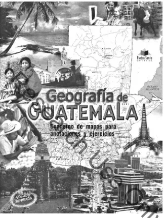
figure 4.12. Cover of the 2007 Geografia de Guatemala: Cuaderno de mapas . . . Note the map’s empha-sis on physical features and political divisions, the use of Piedra Santa’s logo where one might expect to see the word Belize, and the mix of historical and contemporary architecture and peoples on the map, with a reflection on urban and rural life. Courtesy of Irene Piedra Santa.
![figure 4.7. [Miles Rock], manuscript copy of a sketch map of Guatemala, showing areas (1– 5) that he considered should by law be part of Guatemala; of these, Mexico only gave up the area in 3](https://thumb-ap.123doks.com/thumbv2/123dok/4026426.1969846/22.504.81.400.62.552/figure-miles-manuscript-guatemala-showing-considered-guatemala-mexico.webp)